Andy White Anthropology
  • Home
  • Research Interests
    • Complexity Science
    • Prehistoric Social Networks
    • Eastern Woodlands Prehistory
    • Ancient Giants
  • Blog
  • Work in Progress
    • The Kirk Project >
      • Kirk 3D Models list
      • Kirk 3D Models embedded
      • Kirk 2D images >
        • Indiana
        • Kentucky
        • Michigan
        • Ontario
      • Kirk Project Datasets
    • Computational Modeling >
      • FN3D_V3
    • Radiocarbon Compilation
    • Fake Hercules Swords
    • Wild Carolina >
      • Plants >
        • Mosses
        • Ferns
        • Conifers
        • Flowering Plants >
          • Grasses
          • Trees
          • Other Flowering Plants
      • Animals >
        • Birds
        • Mammals
        • Crustaceans
        • Insects
        • Arachnids
        • Millipedes and Centipedes
        • Reptiles and Amphibians
      • Fungi
  • Annotated Publications
    • Journal Articles
    • Technical Reports
    • Doctoral Dissertation
  • Bibliography
  • Data

The Kirk Project: An Update

3/17/2016

3 Comments

 
Picture
I had some time today to upload some current Kirk Project files and do a little re-organization of the pages.  The main page is still located here, but I've split off some of the content that used to be on that page and created separate pages for datasets, a list of 3D models organized by state (so far they're all from South Carolina), embedded links to 3D models organized by ID number, and 2D images. There is nothing on the 2D image page yet, but my plan is to start adding images as I have time.

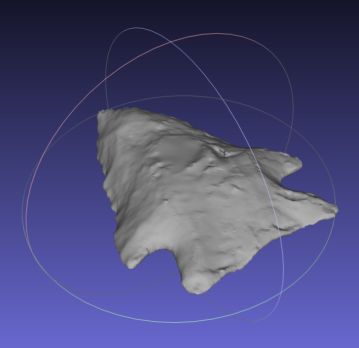
I've been steadily accumulating 3D models (there are 22 now that I've uploaded to Sketchfab). I still haven't started wrestling with them to extract usable morphometric data, but I've got a plan for a paper that will compare variability in the large, surface collected sample from Allendale County (South Carolina) to the variability present in smaller assemblages from excavated contexts (and shorter windows of time). One of those assemblages will be the Nipper Creek cache. Another (hopefully) will be the Kirk material from G. S. Lewis-East.  Hopefully I'll be able to get one or two more "narrow time window" assemblages.

Picture
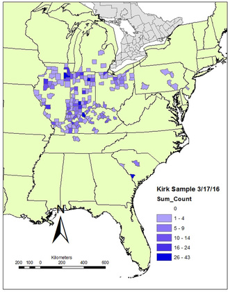
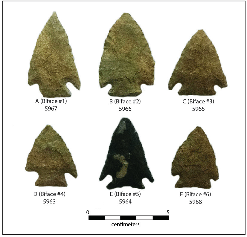
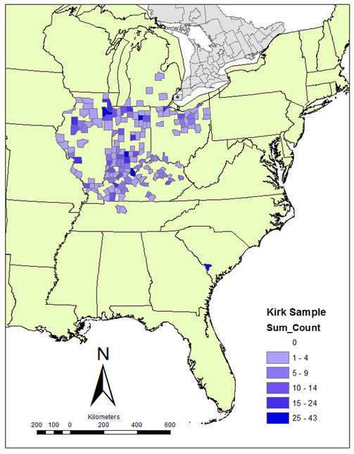
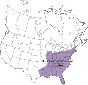
In terms of data, I've produced an updated GIS map of the current sample (n=905). It now includes several points from Pennsylvania (donated by Bill Wagner). I've also provided a file of the metric data that I have for 699 of those points. As explained on the data page, the sample of points for which metric data are available is smaller than the larger Kirk sample because I did not measure all of the points during my dissertation work (some were too fragmentary) and I have not started generating linear measurements of the points I'm adding now.  

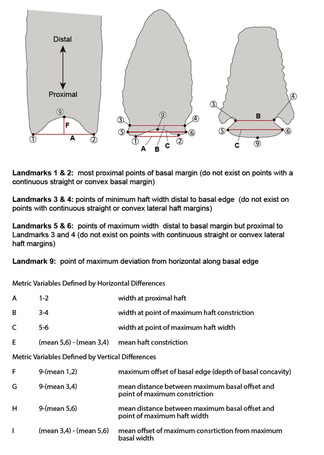
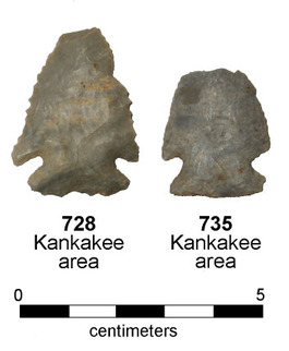
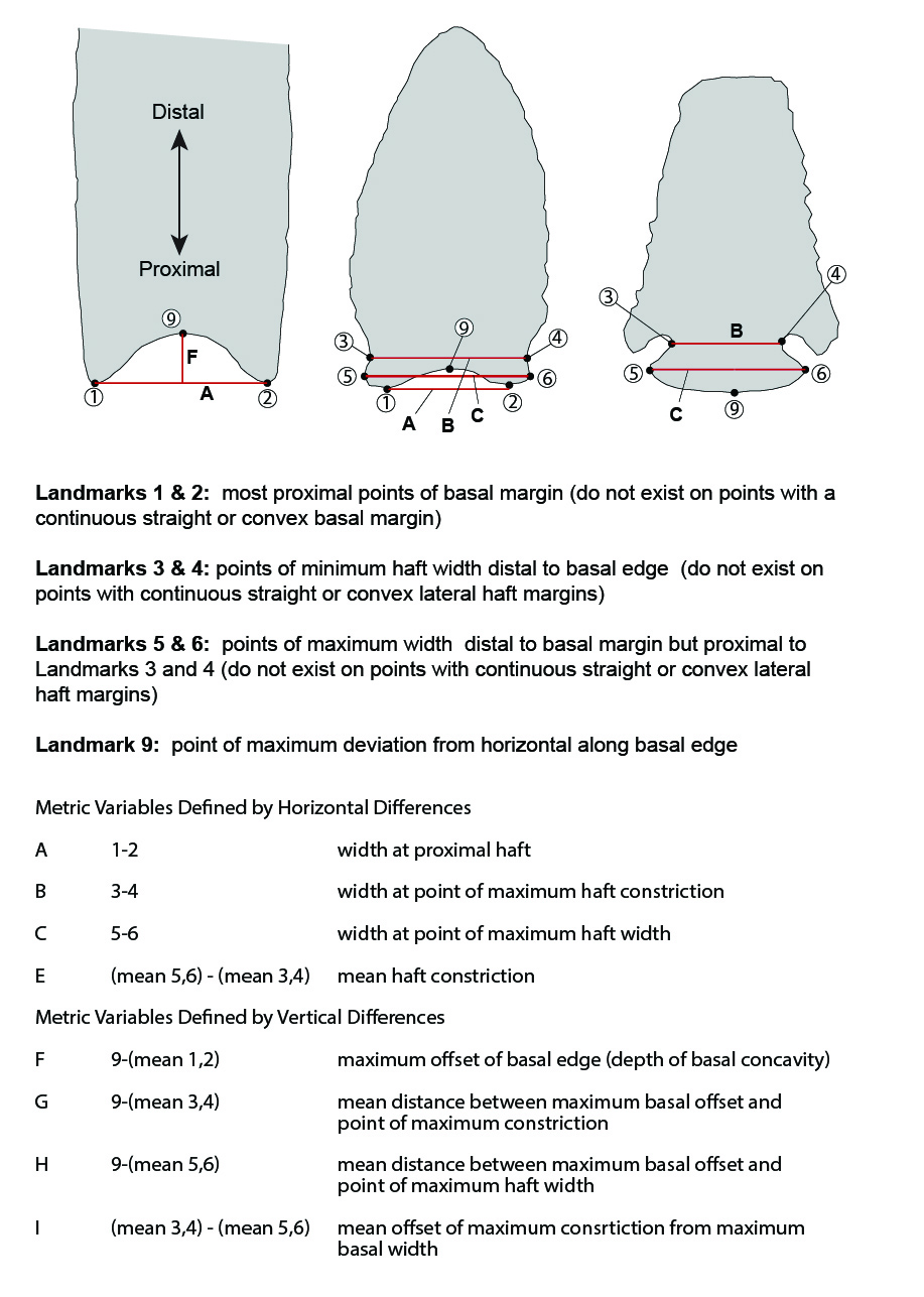
The linear measurements have alphabetic designations (A through I, as defined in this figure). I calculated them by digitizing landmarks using a freeware package, and it was kind of a pain in the butt.  I'm hoping to find a better software package than I used before, and I plan on adding some additional 2D dimensions/angles since I won't also be dealing with lanceolate points.

I did not produce 3D models of any of the points in my dissertation dataset, as I did not have access to the equipment to do that at the time. ​

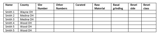
I plan on adding a "Contributors" page soon. And I hope to start incorporating more data from external sources in the dataset. I've got lines on some data from Ohio, Tennessee, and a few other areas. I would love to start filling in Florida, Georgia, and North Carolina.

3 Comments

Kirk Project Presentation at the ASSC Meeting

2/20/2016

4 Comments

 
Picture
Today I'll be giving a short presentation at the annual meeting of the Archaeological Society of South Carolina. Being a new transplant to South Carolina, this will be my first time attending the meeting. I'm looking forward to meeting my new colleagues from around the state and hearing about what they're working on.

I decided to talk about the Kirk Project at today's meeting. Although I've been working on it steadily over the last few weeks, my energies so far have been channeled into prepping the database and streamlining the process for producing 3D models.  So, unfortunately, I don't yet have any coherent data or analysis to present. My presentation is an informal discussion of the question of the Kirk Horizon and what we can do to address it.

Here's a pdf of the slides I'll be talking from today.  Unfortunately I ran out of time to provide complete citations for the parenthetical references.  I'll fill those in and provide a complete version later. 

4 Comments

Submitting Data to the Kirk Project

2/12/2016

5 Comments

 
I've been working on laying the groundwork for the Kirk Project.  I've created a new "Kirk Project" page to organize my various blog posts on the subject as well as house a list of the 3D models I've created and the the current distribution map of the sample (I've also created a sub-page just for the models).  I've also prepared some guidelines for submitting data.  Here they are (and here is a pdf file of the same information):
The Kirk Project
Data Submission Guidelines (2/12/2016)
The Kirk Project is an online initiative to assemble a pan-Eastern dataset of primary data about projectile points associated with the Early Archaic “Kirk Horizon” (dating to about 8,800-6,600 BC).  The Kirk Horizon is marked by a distribution of Kirk Corner Notched points that extends across a huge area, from the lower Great Lakes to the Florida Keys. Its existence has been noted for over four decades (i.e., at least since James Tuck’s 1974 paper “Early Archaic Horizons in Eastern North America”).  There has never been a concerted effort to assemble a dataset of sufficient detail and spatial scope to allow us to characterize and analyze the kinds, amounts, and spatial components of variability among these points. The goal of the Kirk Project is assemble such a dataset.

What Information is Useful?

In order to be useful to the project, information about Kirk points must have at least two components:
​
  • at least a county-level provenience;

  • scaled visual or virtual representation (i.e., a scaled photograph or a 3D model).

If we don’t know where it came from and/or we can’t pull size/shape data from it, the information will be of very limited usefulness to the project and, in my judgement, not worth including. 

The presence of a third piece of information (lithic raw material) is highly desirable but not necessary for inclusion.

NOTE: incomplete/broken points are still useful as long as they retain enough diagnostic characteristics to be lumped into a broad “Kirk” category. If you can tell it’s a Kirk and you know where it came from, chances are that it retains some measurable/classifiable features that would be useful to know about.

A Brief Description of the Database

The main database for the Kirk Project will be a continuation of the relational database I used to record points in northern Indiana and, later, for my dissertation.  Each point in the database (Kirk or otherwise) gets a unique ID number that makes it distinct from all other points. 

The database includes a variety of tables that are linked together (see figure). The main table is “Artifact_Data_Non_metric.”  This table stores the basic information about the point including ID number, other associated “external” numbers (i.e., assigned in collections or publications), general typological classification, raw material, county-level provenience, and some basic non-metric attributes (presence/absence of basal grinding; presence/absence of beveled blade edges, etc.).

As shown in the diagram, several of the fields in “Artifact_Data_Non_metric” link to other tables.  The field “County” links to a table containing the approximate UTM coordinates of the center of the county. The field “ID_No” links to a table containing metric data that I derived from artifact images (for my dissertation).  The structure of the database will undoubtedly change as the project develops.
Picture
The full database contains some information (such as site-level coordinates and information about personal collections) that will not be made publicly available. 

To make the primary data accessible and usable, I will design a query to produce a dataset containing all the Kirk points in the database by unique ID number. Information for each point will include, minimally, other identifying numbers, county-level provenience (and associated UTM coordinates), raw material information, non-metric attributes, available metric data, and links to 3D models if available. I’ll have to figure out how to store and make accessible online all the images that will accompany a spreadsheet of the data.

How Do I Submit Data?

2D Image submission: Each point submitted must be represented by a good-quality, plan view photograph of the point accompanied by a metric scale. Please name the image files with your last name and unique, sequential numbers (for example, Joan Smith submits images of three Kirk points and labels them “Smith 1,” “Smith 2,” and “Smith 3”). 

3D model submission: Points submitted as 3D models should be numbered the same as images (for example, Joan Smith submits models of three Kirk points that are different than those in the images she submitted and labels them “Smith 4,” “Smith 5,” and “Smith 6”).  Save models in STL format.

Both regular 2D images and 3D models should be accompanied by a spreadsheet or table that lists the images/models by their filenames and provides the following information:
Picture
  • Image Name: the file name of the image.
  • County: The county with two-letter state/province abbreviation appended.
  • Site Number: Smithsonian trinomial site designation or Canadian site number.
  • Other Numbers: Numbers assigned for museum curation, other analyses, publication, etc.  Knowing these numbers will help us avoid including the same point more than once.
  • Curated: Where is the point currently kept?
  • Raw Material:  The lithic raw material of the point, if known with a high degree of confidence. If you suspect a certain raw material but have doubts, add a “?” at the end.
  • Basal Grinding:  Score the presence of grinding along the basal edge as “present” or “absent.”
  • Bevel side: Does the point have beveled blade edges?  If so, indicate if the bevel is visible on the left-hand side (LHB) or right-hand side (RHB) when you look at the point with the tip pointed up. If the point is not beveled, leave blank.
  • Bevel class: If the point is beveled, classify the degree of beveling as either “bevel” (there is a strong boundary line between the resharpened edge and the original blade surface that creates a diamond-shaped cross-section) or “twist” (asymmetrically resharpened, but no strong boundary line).
 
Where Do I Send Data?
​

Email your 2D images and spreadsheets to Andy White: aawhite@mailbox.sc.edu.

To transfer 3D models, use an upload/display/download service like Sketchfab (www.sketchfab.com). Sketchfab lets you upload models < 50 MB for free.
5 Comments

A Test 3D Model of a Kirk Corner Notched Point

2/8/2016

6 Comments

 
Okay . . . I'm making some headway. Some of my 3D model creation issues are beginning to yield to good old-fashioned trial-and-error, and I've uploaded a test model to Sketchfab.  The original is a Kirk Point from Allendale County, South Carolina.  I didn't do full color capture on it, but I'll try one of those next.  Take a look at the model and see what you think.

Kirk 5947 (Allendale SC) by aawhite on Sketchfab

6 Comments

The Kirk Project: The Nipper Creek Cache

2/5/2016

14 Comments

 
Don't worry -- I'm not planning on writing about every Kirk point I look at. I've gained some new readers with the whole "Roman sword" debacle, and I hope to not lose all of them as I transition back into writing more about real archaeology and anthropology. Neither the real science nor the stupid ever stops, but I'll try to mix it up somewhat.
I wanted to write a quick post about a small (n = 6) assemblage of Kirk points from the Nipper Creek site (38-RD-18) in Richland County, South Carolina.  The six points were part of a cache that was exposed during a 1986 archaeological field school directed by Albert Goodyear and Ruth Wetmore. (For those unfamiliar with the archaeological use of the term, a "cache" is a group of objects that were hidden or stored for future use.)  The six points were found within a small horizontal area (about 264 square cm, a little over a quarter of a square foot) and within about 5-10 cm vertically.  It is likely that the points were originally placed in a pit (no outline of a pit was discerned) or on a common surface.

Goodyear et al. described the Nipper Creek cache in a short 2004 paper in Current Research in the Pleistocene (see reference below).  I took the opportunity to take a quick color photo of the points as I was scanning them so I could have a visual record cross-referencing the alphabetic designations used in the Goodyear et al. paper with the numeric designations on the bags and the unique ID numbers assigned to the points in my database. 
Picture
Kirk points in the Nipper Creek cache. All except E were made from metavolcanic stone from North Carolina. Point E was made from Ridge and Valley chert, probably obtained in eastern Tennessee.
One really useful thing about an assemblage like the Nipper Creek cache is that it gives us a "snapshot" view of tools from a narrow window of time. Because these six tools all entered the archaeological record together, transferred from a "dynamic" human behavioral context to a "static" archaeological context in a single act, they can potentially tell us something about synchronic variability in Kirk Points that "broad time" surface assemblages cannot. At least some of the variability in Kirk has to be related to change through time -- how do we pin that down? With the aid of stratified deposits and discrete features that provide context.  "Narrow time" deposits like the Nipper Creek cache are potentially of great utility in interpreting the variability that will be present in a "broad time" assemblage of Kirks from across the Eastern Woodlands.

Goodyear, Albert C., William Radisch, Ruth Wetmore, and V. Ann Tippitt.  2004.  A Kirk Corner-Notched Point Cache from the Nipper Creek Site (38RD18), South Carolina.  Current Research in the Pleistocene 21:42-44.

Update (2/11/2016): 3D model of Biface 3 (5965) completed.
​Update (2/12/2016): 3D model of Biface 2 (5966) completed.
Update (2/15/2016): 3D model of Biface 5 (5964) completed.
Update (2/16/2016): 3D model of Biface 4 (5963) completed.
​Update (2/18/2016): 3D model of Biface 1 (5967) completed.
Update (2/19/2016): 3D model of Biface 6 (5968) completed.
14 Comments

The Kirk Project

2/4/2016

23 Comments

 
PictureDistribution of Kirk Corner Notched cluster projectile points (adapted from Justice 1987).
Last Thanksgiving break, I wrote this post about the Early Archaic corner-notched point horizon in the Eastern Woodlands, discussing some of the things we know and pondering some of the questions we can't currently answer. As a refresher, the “Kirk Horizon” (dating to about 8,800-6,600 BC) is marked by a distribution of Kirk Corner Notched points that extends across a huge area, from the lower Great Lakes to the Florida Keys. Its existence has been noted for over four decades (i.e., at least since James Tuck’s 1974 paper “Early Archaic Horizons in Eastern North America”).  

Although many authors have remarked on the striking similarity of Kirk Corner Notched projectile points from across the east, as far as I know there has never been a concerted effort to assemble a dataset of sufficient detail and spatial scope to allow us to characterize and analyze the kinds, amounts, and spatial components of variability among these points. Given how widespread Kirk is, that's a big job.

I assembled a relatively large dataset of Kirk points from the Midwest as part of my 
dissertation work, and have used that information in a couple of publications (e.g., this one and this one).  I've now started the process of adding to that dataset, beginning with information from Kirk points in large collection from Allendale County, South Carolina, that was donated to SCIAA in the 1990's.  I'm working my way through the Kirk Cluster points in that collection, adding them to my existing database and producing 3D digital models. 

Picture
A 3D model of a Kirk point from Allendale County, South Carolina. You can see the smooth facet in the middle of the blade - that's created by the hole left by the little gripper doo-dad I'm using to hold the point for scanning. Holding the points in the middle exposes all the edges which are important for measurements. The smooth spot is annoying, however.
Second, I need to work up a battery of replicable measurements that I can take on the 3D models that will capture aspects of functional and/or stylistic variation. That's going to require learning new software (I'm currently looking at MeshLab, a free product) and doing some thinking about what makes sense.  Using 3D models gives you the opportunity to do things you can't do with calipers, such as examine size/shape of a cross-section positioned anywhere on the point, accurately calculate volume and surface area of portions of the point (just the haft portion, for example), quantify arcs and curves, etc. Figuring out what information I want to extract and how I can extract it will be an iterative process. 
PictureSpatial distribution of Kirk sample by county as it currently sits in my database (889 points total).
The Eastern Woodlands is big. It took me years of intermittent work with both private and institutional collections to assemble my Kirk dataset from the Midwest.  It's going to take me a while to build a dataset of similar size in the South Carolina and the adjacent Atlantic Coast states.  As you can see from the map, I have no data from the deep south or the Northeast.  

If you're like me and are interested in questions about Kirk (including where it comes from and what it can tell us about the Early Archaic societies of the Eastern Woodlands), I ask you to think about the idea of producing the largest-ever Kirk dataset ever assembled. How similar are Kirks, really, across this large area? How does variability within Kirk break down according to space? Can we identify regional differences in "stylistic" variation?  Are there discontinuities or is variability clinal? What about regional differences in the scales of raw material transport? Is morphometric variability isomorphic with lithic raw materials? Can we identify regional variation in "functional" attributes such as resharpening patterns, haft size, blade configuration, etc.?  Just from looking about the first 30-40 Kirk points I've examined from South Carolina, I'm guessing there might be a higher incidence of beveling (all left hand beveling so far) here than in the Midwest.

Anyway, this post isn't supposed to be high pressure. I won't necessarily be able to devote a great deal of time to this on any given day. I'm just letting you know that if you're interested in Kirk and want to think big, I'm right there with you. Let me know if you want to participate in an effort to create a massive Kirk dataset that we can use to address all kind of potentially interesting questions about early Holocene hunter-gatherers in the Eastern Woodlands. Please pass it on to anyone you think might be interested.


Update (2/12/2016): Guidelines for contributing data to the Kirk Project.
23 Comments

Early Eastern Hunter-Gatherers and Holiday Travel

11/24/2015

0 Comments

 
If you’re like me, there’s always some part of your brain that is thinking about hunter-gatherers.  Sometimes when I’m at work the percentage can get as high as 95 percent.  Most of the time it’s lower, of course, but it never gets down to zero. I’m always on duty.

Yes, I just said that with a straight face. And yet I'm a surprisingly poor poker player.
Picture
Columbia, South Carolina, November 2015.
Picture
Ann Arbor, Michigan, November 2015.
Over the last few days, I’ve travelled by car, air, and then car again to get from South Carolina to northern Georgia, Georgia to central Indiana (that was the air leg), then central Indiana to southeast Michigan.  The purpose of the trip is to see family over the Thanksgiving break.  But it also served up a reminder of the nature of seasonal differences in environment across the Eastern Woodlands.  As a recent transplant from the Midwest to South Carolina, my seasonal clock is still adjusting: how can the semester be coming to a close when I’m still gardening in a short sleeve shirt?  Seeing my breath on the jetway after landing in Indianapolis nudged my seasonal clock forward; the drive north to an Ann Arbor blanketed in snow finished off the reboot.  

The quick transplantation back to Ann Arbor made me ponder how hunter-gatherer societies would have handled regions of the Eastern Woodlands with such contrasts in the character, severity, and potential suddenness of seasonal changes.  Just as Midwesterners today have to employ a set of behavioral and cultural strategies to deal with winter that is quite different from those necessary to survive the occasional day in Columbia when the temperature dips below freezing, there is no way that hunter-gatherers in the temperate Great Lakes could spend the winter doing the same things as hunter-gatherers in the sub-tropical Carolinas.   This is not a profound idea, of course:  hunter-gatherers have to deal with the characteristics of their environments in very direct ways, and whatever the particular social, cultural, and behavioral characteristics of a hunter-gatherer system, those characteristics have to allow the system to “fit” within its environment.  Environment isn’t everything, but it’s important.
One of the interesting things about the hunter-gatherer archaeology of the Eastern Woodlands is that, for some chunks of early Holocene prehistory, some aspects of material culture appear to be amazingly uniform across vast regions of space.  An Early Archaic “Kirk Horizon” (dating to about 8,800-6,600 BC) is marked by a distribution of Kirk Corner Notched points that extends north-south from the southern Great Lakes to the Gulf Coast and east-west from the Mississippi corridor to the Atlantic.  That's a big area.  
PictureDistribution of Kirk Corner Notched cluster projectile points (adapted from Justice 1987).
And not only does this initial "horizon" emerge in the context of what by all appearances are very thinly distributed, highly mobile hunter-gatherer populations, but projectile points styles seem to change in lockstep across this same region of North America for at least some time after.  How can we explain this?  Although lithic raw material data suggest that Kirk groups were highly mobile (e.g., see this paper) the area of the "horizon" is much too large for it to be the product of a single group of people: the hunter-gatherers discarding Kirk points in Ontario are not the same individuals as those discarding Kirk points in Florida.

But that doesn't mean they weren't part of the same society.  We can define a "society" as a population defined by the existence of social ties among and between groups and individuals.  Ethnographic hunter-gatherers have numerous mechanisms for creating and maintaining social ties (e.g., marriage, exchange, group flux, periodic aggregation), and there is no reason to suspect that all of those same behaviors were not utilized to knit together the social fabric of early Holocene hunter-gatherers in the Eastern Woodlands.  Maintaining social ties that extend beyond "over the horizon" may be especially important to high mobility hunter-gatherers operating at low population densities, as such ties allow local populations to gather information about large areas of the landscape.

PictureA couple of Kirk cluster points from northwest Indiana.
So maybe the apparent uniformity of lithic style that we recognize as the Kirk "horizon" emerged as simply the unintentional product of the presence of a continuous, "open" social network that stretched across the Eastern Woodlands. That's a logical possibility. Demonstrating that such an explanation is plausible, however, is a multi-faceted problem.  

First, you need data that actually let you characterize the degree of variability in the Kirk Corner Notched cluster and how that variability breaks down with regard to space (and raw material use). Given how widespread Kirk is, that's a big job.  But it's a doable job with the right commitment: Kirk points are common and fairly easy to recognize (they really are remarkably similar in different parts of the east, at least the ones I've looked at). I started working on assembling a Kirk dataset from the Midwest as part of my dissertation work and grant work while I was at IPFW.  I'm going to continue that work down south: I've applied for some grant money to start working on inventorying and collecting data from a large collection of points from Allendale County, South Carolina, and there are numerous other existing collections available.  My plan is to create 3D models of the points as I analyze them, which will aid in both morphometric analysis and data sharing. I don't think I'll have to create the whole Kirk database myself (see this post about 3D modeling of points from the Hardaway site in North Carolina). 

Second, it's a modeling problem.  How much interaction across a social landscape the size of the eastern United States would be required to produce and maintain the degree of stylistic uniformity that we see? You can't answer that without a model that lets you understand how patterns of social interaction might affect patterns of artifact variability (run-of-the-mill equation-based cultural transmission models won't cut it, either, because they typically don't take spatially-structured interaction into account).  I started to try to tackle that question in my dissertation and with some other modeling work. The simple assumption that the degree of homogeneity would be proportional to the degree of interaction is probably wrong: network theory suggests to me that a nonlinear relationship is more likely (a small degree of interaction can produce a large degree of homogeneity).

Picture
Finally, circling back to the beginning of the post, we need to have some understanding of environmental variability across the Eastern Woodlands and the implications of that variability in terms of the hunter-gatherer societies that dealt with it. While there are some environmental commonalities in terms of plants and animals that help unify the Eastern Woodlands as a single macro region (and a “culture area” throughout prehistory), it's obviously not all the same.  Seasonal differences in the weather would not only affect human behaviors directly, but indirectly through their effects on primary game species such as white-tailed deer. I'm not a deer hunter or a wildlife biologist, but the contrasts between the modern deer-hunting practices and laws in Midwestern states (e.g., Ohio, Michigan, Indiana) and in South Carolina are striking in terms of the length of season, the bag limits, etc. While I'm sure that modern history, culture, and land-use play some role in these differences, I would be very surprised to find that environmental differences don't contribute significantly to the amount of hunting that deer populations can bear in these different regions.

Significant differences in the density and behaviors of deer populations would have had implications for the hunter-gatherer populations that exploited them, perhaps especially during the Fall and Winter.  I would guess that variability in deer populations and behavior vary continuously across the Eastern Woodlands along with other aspects of environment (temperature, mast production, etc.). Different strategies, perhaps involving patterns of seasonal mobility and aggregation, would have surely been required in the far north and far south of the region. Whatever the components of those differences, however, they were apparently not sufficient to produce hunter-gatherer societies that were disconnected on the macro level during the Early Archaic period. It may be the case, in fact, that differences in seasonality across the region, in a context of low population densities, actually encouraged rather than discouraged the creation of an "open" social network that resulted in the emergence of the Kirk Horizon. Later on in the Archaic we do indeed see a regionalization of material culture that makes the Midwest look different from the Southeast.

Whatever the characteristics of their larger social networks (and smaller social units within those networks), those Early Archaic societies provided a foundation for much of the Eastern Woodlands prehistory that follows. It's going to require theory-building and a lot of data from a large area to understand it. We need some kind of Kirk Manhattan Project.

0 Comments
Forward>>

    All views expressed in my blog posts are my own. The views of those that comment are their own. That's how it works.

    I reserve the right to take down comments that I deem to be defamatory or harassing. 

    Andy White

    Follow me on Twitter: @Andrew_A_White

    Email me: andy.white.zpm@gmail.com

    Enter your email address:

    Delivered by FeedBurner


    Picture

    Sick of the woo?  Want to help keep honest and open dialogue about pseudo-archaeology on the internet? Please consider contributing to Woo War Two.
    Picture

    Follow updates on posts related to giants on the Modern Mythology of Giants page on Facebook.

    Archives

    January 2023
    January 2022
    November 2021
    September 2021
    August 2021
    March 2021
    June 2020
    April 2020
    March 2020
    January 2020
    December 2019
    November 2019
    October 2019
    September 2019
    May 2019
    April 2019
    January 2019
    December 2018
    November 2018
    October 2018
    September 2018
    August 2018
    July 2018
    June 2018
    May 2018
    April 2018
    March 2018
    February 2018
    January 2018
    December 2017
    November 2017
    October 2017
    September 2017
    August 2017
    July 2017
    June 2017
    May 2017
    April 2017
    March 2017
    February 2017
    January 2017
    December 2016
    November 2016
    October 2016
    September 2016
    August 2016
    July 2016
    June 2016
    May 2016
    April 2016
    March 2016
    February 2016
    January 2016
    December 2015
    November 2015
    October 2015
    September 2015
    August 2015
    July 2015
    June 2015
    May 2015
    April 2015
    March 2015
    February 2015
    January 2015
    December 2014
    November 2014
    September 2014
    August 2014
    June 2014
    May 2014
    April 2014
    March 2014

    Categories

    All
    3D Models
    AAA
    Adena
    Afrocentrism
    Agent Based Modeling
    Agent-based Modeling
    Aircraft
    Alabama
    Aliens
    Ancient Artifact Preservation Society
    Androgynous Fish Gods
    ANTH 227
    ANTH 291
    ANTH 322
    Anthropology History
    Anunnaki
    Appalachia
    Archaeology
    Ardipithecus
    Art
    Atlantis
    Australia
    Australopithecines
    Aviation History
    Bigfoot
    Birds
    Boas
    Book Of Mormon
    Broad River Archaeological Field School
    Bronze Age
    Caribou
    Carolina Bays
    Ceramics
    China
    Clovis
    Complexity
    Copper Culture
    Cotton Mather
    COVID-19
    Creationism
    Croatia
    Crow
    Demography
    Denisovans
    Diffusionism
    DINAA
    Dinosaurs
    Dirt Dance Floor
    Double Rows Of Teeth
    Dragonflies
    Early Archaic
    Early Woodland
    Earthworks
    Eastern Woodlands
    Eastern Woodlands Household Archaeology Data Project
    Education
    Egypt
    Europe
    Evolution
    Ewhadp
    Fake Hercules Swords
    Fetal Head Molding
    Field School
    Film
    Florida
    Forbidden Archaeology
    Forbidden History
    Four Field Anthropology
    Four-field Anthropology
    France
    Genetics
    Genus Homo
    Geology
    Geometry
    Geophysics
    Georgia
    Giants
    Giants Of Olden Times
    Gigantism
    Gigantopithecus
    Graham Hancock
    Grand Valley State
    Great Lakes
    Hollow Earth
    Homo Erectus
    Hunter Gatherers
    Hunter-gatherers
    Illinois
    India
    Indiana
    Indonesia
    Iowa
    Iraq
    Israel
    Jim Vieira
    Jobs
    Kensington Rune Stone
    Kentucky
    Kirk Project
    Late Archaic
    Lemuria
    Lithic Raw Materials
    Lithics
    Lizard Man
    Lomekwi
    Lost Continents
    Mack
    Mammoths
    Mastodons
    Maya
    Megafauna
    Megaliths
    Mesolithic
    Michigan
    Middle Archaic
    Middle Pleistocene
    Middle Woodland
    Midwest
    Minnesota
    Mississippi
    Mississippian
    Missouri
    Modeling
    Morphometric
    Mound Builder Myth
    Mu
    Music
    Nazis
    Neandertals
    Near East
    Nephilim
    Nevada
    New Mexico
    Newspapers
    New York
    North Carolina
    Oahspe
    Oak Island
    Obstetrics
    Ohio
    Ohio Valley
    Oldowan
    Olmec
    Open Data
    Paleoindian
    Paleolithic
    Pilumgate
    Pleistocene
    Pliocene
    Pre Clovis
    Pre-Clovis
    Prehistoric Families
    Pseudo Science
    Pseudo-science
    Radiocarbon
    Reality Check
    Rome
    Russia
    SAA
    Sardinia
    SCIAA
    Science
    Scientific Racism
    Sculpture
    SEAC
    Search For The Lost Giants
    Sexual Dimorphism
    Sitchin
    Social Complexity
    Social Networks
    Solutrean Hypothesis
    South Africa
    South America
    South Carolina
    Southeast
    Stone Holes
    Subsistence
    Swordgate
    Teaching
    Technology
    Teeth
    Television
    Tennessee
    Texas
    Topper
    Travel
    Travel Diaries
    Vaccines
    Washington
    Whatzit
    White Supremacists
    Wisconsin
    Woo War Two
    World War I
    World War II
    Writing
    Younger Dryas

    RSS Feed

    Picture
Proudly powered by Weebly