Data Submission Guidelines (2/12/2016)
What Information is Useful?
In order to be useful to the project, information about Kirk points must have at least two components:
- at least a county-level provenience;
- scaled visual or virtual representation (i.e., a scaled photograph or a 3D model).
If we don’t know where it came from and/or we can’t pull size/shape data from it, the information will be of very limited usefulness to the project and, in my judgement, not worth including.
The presence of a third piece of information (lithic raw material) is highly desirable but not necessary for inclusion.
NOTE: incomplete/broken points are still useful as long as they retain enough diagnostic characteristics to be lumped into a broad “Kirk” category. If you can tell it’s a Kirk and you know where it came from, chances are that it retains some measurable/classifiable features that would be useful to know about.
A Brief Description of the Database
The main database for the Kirk Project will be a continuation of the relational database I used to record points in northern Indiana and, later, for my dissertation. Each point in the database (Kirk or otherwise) gets a unique ID number that makes it distinct from all other points.
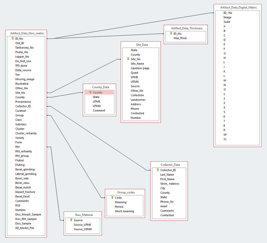
The database includes a variety of tables that are linked together (see figure). The main table is “Artifact_Data_Non_metric.” This table stores the basic information about the point including ID number, other associated “external” numbers (i.e., assigned in collections or publications), general typological classification, raw material, county-level provenience, and some basic non-metric attributes (presence/absence of basal grinding; presence/absence of beveled blade edges, etc.).
As shown in the diagram, several of the fields in “Artifact_Data_Non_metric” link to other tables. The field “County” links to a table containing the approximate UTM coordinates of the center of the county. The field “ID_No” links to a table containing metric data that I derived from artifact images (for my dissertation). The structure of the database will undoubtedly change as the project develops.
To make the primary data accessible and usable, I will design a query to produce a dataset containing all the Kirk points in the database by unique ID number. Information for each point will include, minimally, other identifying numbers, county-level provenience (and associated UTM coordinates), raw material information, non-metric attributes, available metric data, and links to 3D models if available. I’ll have to figure out how to store and make accessible online all the images that will accompany a spreadsheet of the data.
How Do I Submit Data?
2D Image submission: Each point submitted must be represented by a good-quality, plan view photograph of the point accompanied by a metric scale. Please name the image files with your last name and unique, sequential numbers (for example, Joan Smith submits images of three Kirk points and labels them “Smith 1,” “Smith 2,” and “Smith 3”).
3D model submission: Points submitted as 3D models should be numbered the same as images (for example, Joan Smith submits models of three Kirk points that are different than those in the images she submitted and labels them “Smith 4,” “Smith 5,” and “Smith 6”). Save models in STL format.
Both regular 2D images and 3D models should be accompanied by a spreadsheet or table that lists the images/models by their filenames and provides the following information:
- Image Name: the file name of the image.
- County: The county with two-letter state/province abbreviation appended.
- Site Number: Smithsonian trinomial site designation or Canadian site number.
- Other Numbers: Numbers assigned for museum curation, other analyses, publication, etc. Knowing these numbers will help us avoid including the same point more than once.
- Curated: Where is the point currently kept?
- Raw Material: The lithic raw material of the point, if known with a high degree of confidence. If you suspect a certain raw material but have doubts, add a “?” at the end.
- Basal Grinding: Score the presence of grinding along the basal edge as “present” or “absent.”
- Bevel side: Does the point have beveled blade edges? If so, indicate if the bevel is visible on the left-hand side (LHB) or right-hand side (RHB) when you look at the point with the tip pointed up. If the point is not beveled, leave blank.
- Bevel class: If the point is beveled, classify the degree of beveling as either “bevel” (there is a strong boundary line between the resharpened edge and the original blade surface that creates a diamond-shaped cross-section) or “twist” (asymmetrically resharpened, but no strong boundary line).
Where Do I Send Data?
Email your 2D images and spreadsheets to Andy White: [email protected].
To transfer 3D models, use an upload/display/download service like Sketchfab (www.sketchfab.com). Sketchfab lets you upload models < 50 MB for free.


 RSS Feed
