A desire to find intact deposits and the contextual information they offer underlies a lot of archaeology. You can do plenty of interesting and useful things with artifacts and sites that don't have that kind of information, of course, but there are some questions that you really can't ask of surface assemblages of projectile points or flake scatters that are contained completely within the plowzone.
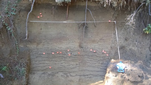
The landowner, generous enough to let us on the property to begin with, was excited about what we saw and agreed that I could go back and do some work to clean and document the profile. I returned to the site last week and worked on the 2 m section shown in the photo. The pieces of orange flagging tape mark the locations of in situ cultural materials in the wall. The deep zone with most of the artifacts (most of which are quartz debris) is slightly darker than the sediment above and was (I think) probably formed during an occupation of the levee some 6000-5000 years ago. That guesstimated date comes from the single diagnostic artifact recovered so far: a Middle Archaic Guilford point. The point, also of quartz, wasn't found in the wall but came out of the slump (screened) immediately in front of the wall. I think it probably came out of the artifact zone and therefore probably dates that zone to the Middle Archaic. If the point fell out of the wall from higher up, however, that means that the artifact zone pre-dates the Middle Archaic (which would also be awesome). It's a win no matter how you slice it. And the whole deposit is sand. That's a win-win. Or maybe even a win-win-win.
Weather permitting, I'll be back out at the site tomorrow to try to grab another 2-3 meters of profile.
I think there are tremendous and varied possibilities for excellent research at places like this, and I'm pretty happy to have been directed to a site with such obvious potential so soon after I got here. I owe a big thanks to Al and to the landowner for making it happen. Stay tuned!






 RSS Feed
