Andy White Anthropology
  • Home
  • Research Interests
    • Complexity Science
    • Prehistoric Social Networks
    • Eastern Woodlands Prehistory
    • Ancient Giants
  • Blog
  • Work in Progress
    • The Kirk Project >
      • Kirk 3D Models list
      • Kirk 3D Models embedded
      • Kirk 2D images >
        • Indiana
        • Kentucky
        • Michigan
        • Ontario
      • Kirk Project Datasets
    • Computational Modeling >
      • FN3D_V3
    • Radiocarbon Compilation
    • Fake Hercules Swords
    • Wild Carolina >
      • Plants >
        • Mosses
        • Ferns
        • Conifers
        • Flowering Plants >
          • Grasses
          • Trees
          • Other Flowering Plants
      • Animals >
        • Birds
        • Mammals
        • Crustaceans
        • Insects
        • Arachnids
        • Millipedes and Centipedes
        • Reptiles and Amphibians
      • Fungi
  • Annotated Publications
    • Journal Articles
    • Technical Reports
    • Doctoral Dissertation
  • Bibliography
  • Data

Broad River Archaeological Field School: 2018, Week 2

1/30/2018

6 Comments

 
Last Friday was our second day in the field. We had another sunny day with temperatures starting around freezing but warming up to the mid-60's by the afternoon. As far an January working weather goes, I'll take it.

Other than educating students and directing the excavation, I had one main job: bring ground coffee and filters. I botched it. I won't fail again. I promise.

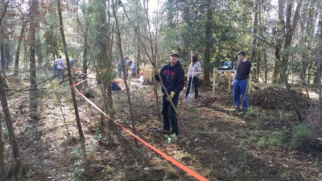
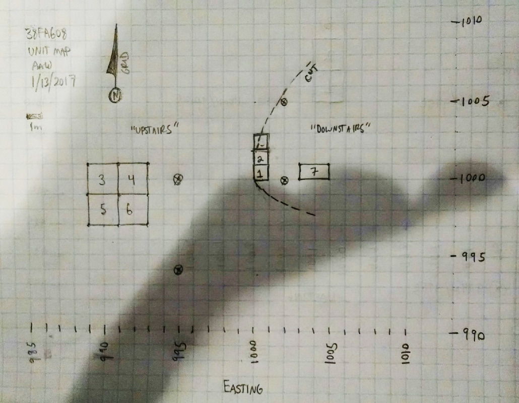
We started the day going over the basic components of our record-keeping system: the Field Specimen (FS) log, the unit/level forms, bag labels, and individual notebooks. I explained to the students how all of these things work together to match the materials we collect to the contexts from which we have removed those materials. The FS system I use is a kind of single context recording system that assigns unique numbers to unique proveniences of artifacts and samples. Redundancies built into the information that goes in the FS log, on the forms, and on the bags provide a way to catch and fix errors.

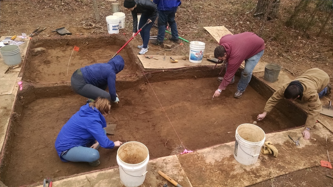
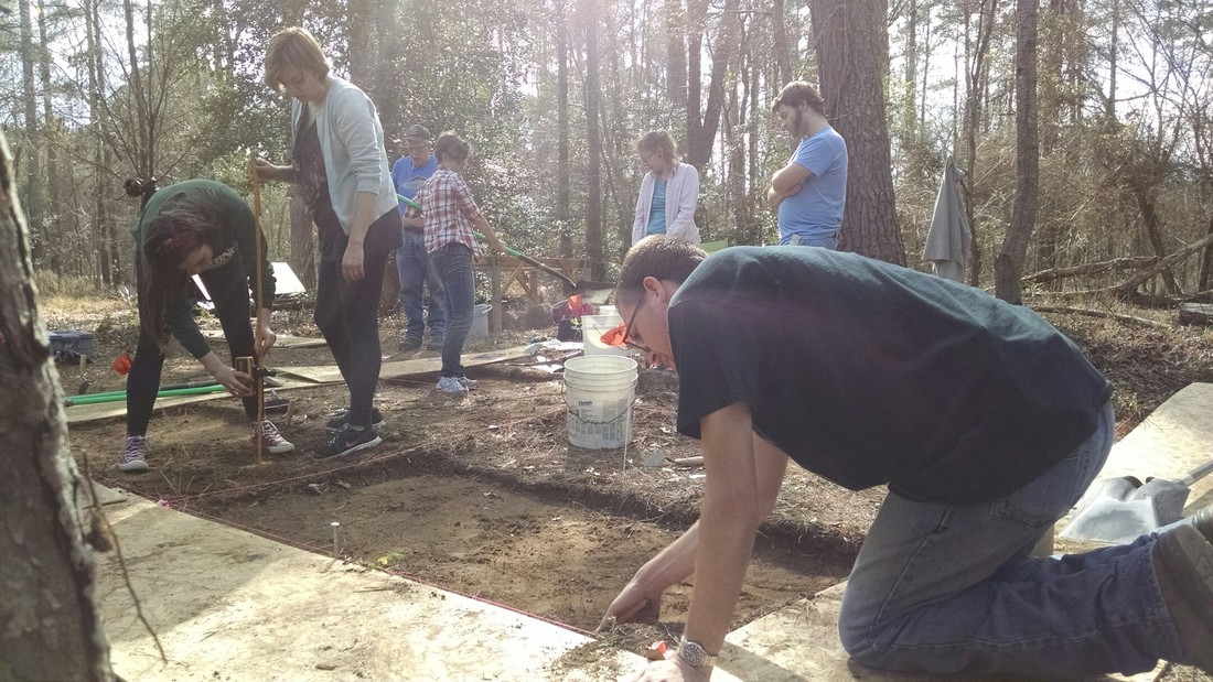
There was a little bit of water in the block that we bailed while removing the plastic. The main activities for the day were resuming excavation in Unit 5 and getting started on a unit extending the block to the north (Unit 12). 

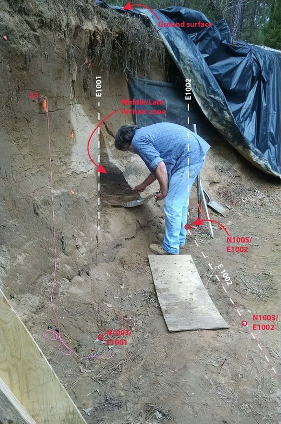
At the end of last year's excavation, the floor of Unit 5 was 20 cm higher than the floor of Units 4 and 6. Unit 5 was the only unit in the block where we maintained a consistent piece-plot strategy all the way down after the first plowzone. That, along with a large number of roots, slowed things down. My plan is to maintain the piece-plot methodology in Unit 5 in perpetuity, as it will provide us with a consistent column of high resolution data down through the deposits.

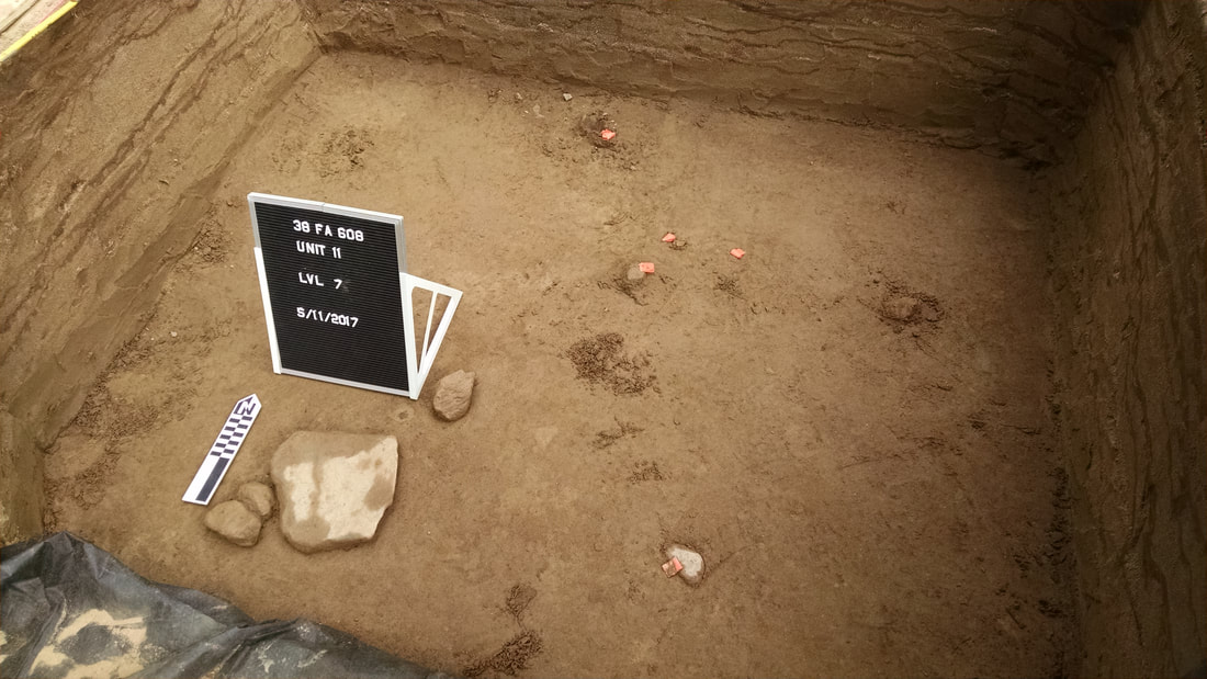
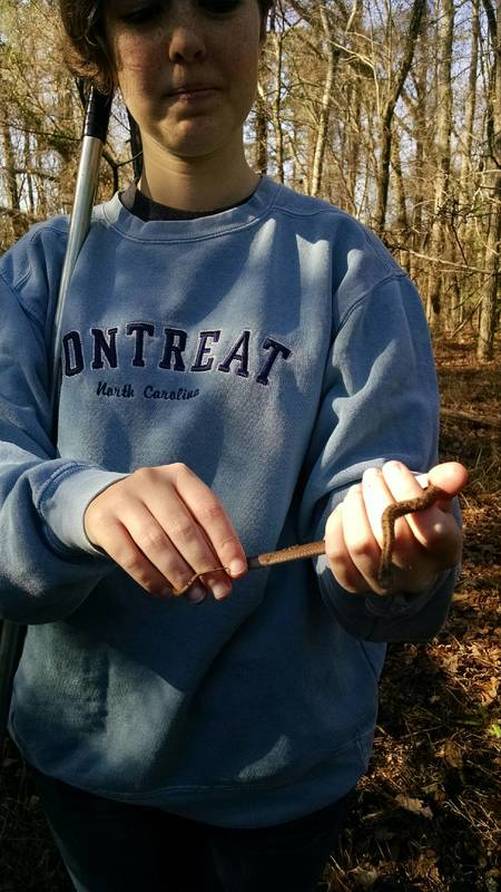
Removing the landscape fabric from the floor of Unit 5 revealed some minor damage from ant tunnels. Sam and a crew of two students got to work cleaning the surface with trowels and beginning excavation of level 7.
Picture
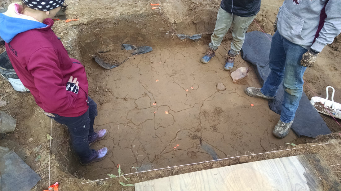
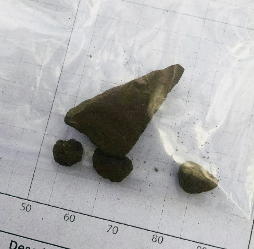
Ant tunnels beneath the landscape fabric in Unit 5. The pieces of orange flagging tape mark the locations of artifacts in the floor, identified but left in place last season.
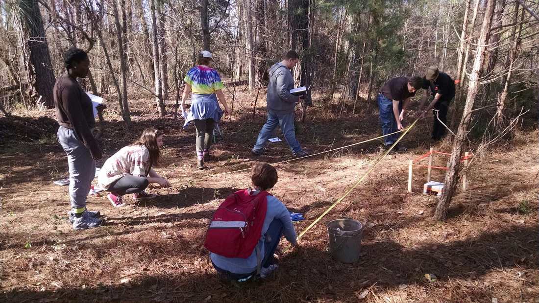
Unit 12 is a 2m x 2m unit abutting the north edge of Unit 4. My goal in opening and excavating this unit is to get it down to the level of the floor in Units 4 and 6, exposing the northern portion of a cultural feature (probably a Late Archaic pit feature) that extends outside of Unit 4. As in the first unit/levels last year, we started Unit 12 by excavating arbitrary levels in 1m x 1m quadrants of the unit. This gives the students a chance to get some experience with controlled excavation while we're still up in the plowzone, where mistakes don't actually cost you any data.
Picture
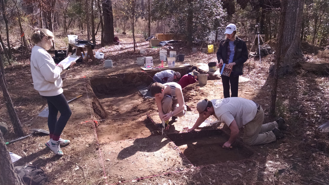
Completion of the first levels in the NW (right) and SE (left) quadrants of Unit 12.
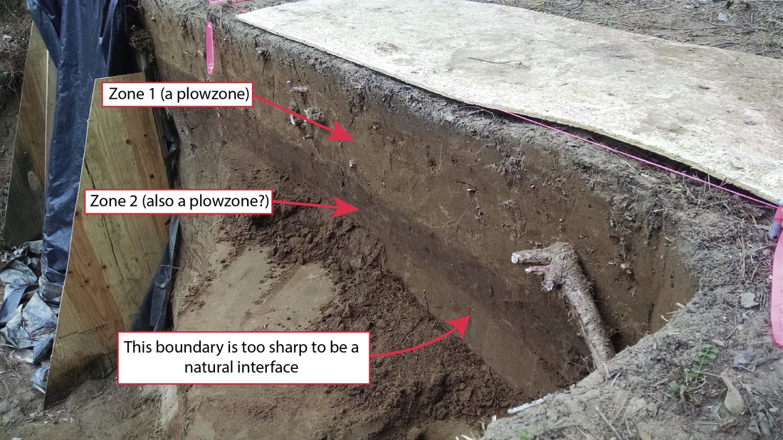
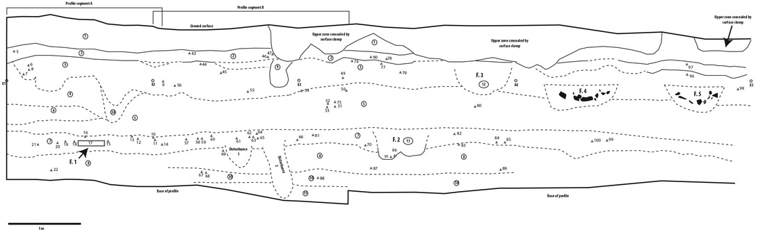
.After the students get some reps digging arbitrary levels in near-surface contexts, we'll strip the remainder of the plowzones (there are two plowzones, remember) as natural levels and get down into what's underneath. In some places in the block and the machine profile, there appeared to be lenses of unplowed sheet midden and/or a natural A horizon beneath the lower plowzone (Zone 2). We'll be on the lookout for those as well as for truncated features extending from base of the second plowzone.

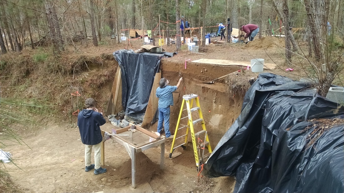
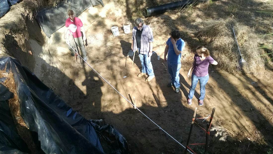
The floor and walls of Units 4 and 6 remain covered by backfill for now. While having that dirt in there makes for some ugly pictures, its presence protects the unexcavated deposits from our feet and from the water that will get in the block (and the bailing to remove the water). It also provides support to the fragile cut wall between Unit 5 and Unit 6, and allows us to have a ramp to get in and out of the block. It's better to have some ugly photos than to lose the archaeology through weeks of trampling.

​As promised, I made a video of our activities in Week 2. Enjoy!
6 Comments

Broad River Archaeological Field School: 2018, Week 1

1/22/2018

0 Comments

 
Last year, I wrote a blog post after every day of field school. This year I'm going to try something different. My plan is to create a short (5-10 minute) video that shows and describes our activities each day in the field. While the blog posts were useful for both research and public communication (and I plan to write when I need to talk about particular things in more detail), I think I might be able to expand my audience by making our work accessible through video. 

I hope to have a video from each Friday posted by the following Monday on my YouTube channel. Here's the first installment. Enjoy!
0 Comments

Radiocarbon Dates from 38FA608 Published in "Legacy"

12/14/2017

5 Comments

 
Picture
I wrote a short article for the December 2017 edition of Legacy (Vol. 21, No. 2, available here) about the radiocarbon dates from 38FA608. I wanted to make the dates available (in a way that they can be cited) sooner rather than later. I'll probably wait until after the next season of fieldwork to produce a more formal, peer-reviewed article about the site. 

As pointed out by Stuart Fiedel in the comments on my initial blog post about these dates, the date from 38FA608 is apparently only the second radiocarbon date associated with Guilford points.  This is despite the fact that the distribution of Guilford stretches from southern Maryland to northern Georgia. Gunn and Foss (1992) reported the first date of 5350 +/- 60 from a Guilford feature at the Copperhead Hollow site (38CT58) in Chesterfield County, South Carolina. The scarcity of Guilford dates presumably reflects the rarity of intact deposits that date to this time period. It is clear that Zone 7 of 38FA608 has the potential to provide significant new information about the late Middle Archaic in the Carolina Piedmont in particular and in the Eastern Woodlands in general. 


Season 2 of the field school will be starting up in late January. Watch this space.
5 Comments

38FA608: The First Radiocarbon Dates

10/20/2017

3 Comments

 
I recently announced the return of the Broad River Archaeological Field School for the spring semester of 2018.  Student registration begins in November, and the logistical and strategic wheels are in motion.

This week I received radiocarbon dating results from two samples I submitted to Beta Analytic. Radiocarbon dates are not cheap (about $600 for an AMS analysis that returns an age estimate from a very small sample), and I am grateful to a private donor who supplied funds to date one of the samples from 38FA608.

Here are the date results on a generalized figure of the stratigraphy at 38FA608 as I currently understand it (based on profiles of Units 1, 2, 9, 11, and the original machine cut):​ 
Picture
Generalized stratigraphy at 38FA608.
The date for Zone 7 -- from a single piece of charcoal that Jim Legg picked out of the profile of Unit 9 -- came back right at the Middle/Late Archaic transition. It's a date that's consistent with Zone 7 being related to the Guilford point fragments that we've gotten from the site (only one of which has actually been found in situ).  Thus my original suspicion of a Middle Archaic age for Zone 7 is supported.

The date for the Zone 19 sample, however . . . was a bit of a surprise. It also came back as Middle Archaic in age, about 700-800 calendar years older than Zone 7.

I only wrote briefly about Unit 11, which I and several volunteers put in after field school to get our first good look at what is beneath the deposits exposed by the original machine cut.  There wasn't much material until we neared the boundary of a seasonal water table. Right above that, there were some large cobbles and a very light scattering of small, angular quartz fragments. As I wrote back in May, none of the cobbles appears to have been modified (at least based on a macro inspection), and none of the pieces of angular quartz is a slam dunk for a human-made stone tool. Other than human deposition, however, I can't think of a good explanation for how that material got there -- it is so unlike its sandy matrix in terms of size that it could not have been transported by the same mechanism.
Picture
Excavation of Unit 11 in progress. Large rocks are sitting at the boundary between Zones 15 and 16 as shown in the profile below.
Picture
Annotated profile photo of north wall of Unit 11. Dated charcoal sample (FS 1318) shown in situ in Zone 19.
I dated a single piece of charcoal plucked from the wall of Unit 11 (FS 1318) from a zone beneath the "cultural" material in an attempt to learn something about where those deposits might be in time. Given what seemed to be a fairly regular accumulation of the sand from the Middle Archaic though the Woodland period, I was expecting an Early Holocene rather than a Middle Holocene age -- I thought we might be looking at the edge of an Early Archaic deposit. 

​There are two main possibilities for the date: (1) it accurately dates the age of Zone 19; or (2) it doesn't.

It's possible that that piece of charcoal worked it's way down through the sand from a higher elevation, perhaps through bioturbation (movement by animals or roots). There's no obvious signs of intrusion from where the sample was taken, but that doesn't mean much in these old sands: we wouldn't necessarily expect that subtle signs of intrusion would be discernible in these kinds of sediments after 6000 years. 

So the date could be "bad" in the sense that it isn't giving us the age of the deposit. I think it's entirely possible, however, that it is accurate. While the idea of a slow and steady accumulation of sand over the course of the Archaic is appealing, there's no reason to assume that that's how it went down. It's possible that rates of deposition varied. The levee could have aggraded more rapidly during the Middle Holocene, perhaps as a function of both Middle Holocene climate and the lower elevation of the existing surface at that time (making it easier for the landform to be over-topped by flood waters). 

If Zone 19 really dates to around 4700 BC, the deposits in Zone 15 could be related to a deeply-buried Morrow Mountain occupation. 

Investigating the deep deposits at 38FA608 is a top priority for excavations in the spring. Stay tuned!
3 Comments

The Broad River Archaeological Field School, Round 2

10/11/2017

1 Comment

 
I'm happy to announce that I'll be teaching an archaeological field school again during the Spring semester. We'll be returning to site 38FA608 in Fairfield County, South Carolina, for a second season of fieldwork.  The course will be listed as ANTH 322 (722 for graduate students) and the basic details will remain the same: every Friday from 8:00-4:00, transportation provided.  You can learn all about last year's adventures through blog posts on the Broad River Archaeological Field School website and through a summary article in Legacy.
Picture
The Spring 2017 field season helped us learn a tremendous amount about the natural and cultural deposits at 38FA608. The discovery of a buried Mack (Late Archaic/Early Woodland, ca. 2000 BC) component was one of the big surprises. There is also evidence of a slightly earlier Savannah River component (perhaps represented by several intact pit features). There are tantalizing suggestions of a deeply-buried component that could date to the Early Archaic period.  The basic laboratory processing of the materials from 2017 has been completed, and I'm working on an analysis as time permits. I sent to radiocarbon samples off to Beta Analytic last week (one from the deeply buried zone that I'm betting is Middle Archaic in age, and one from the lowest zone exposed in our post-field school Unit 11 excavations last May).

The 2017 field season has set us up very nicely for work in 2018.  My two main goals are to: (1) excavate several of the pit features that almost certainly belong to the Mack and/or Savannah River components; and (2) make a more extensive exploration of the deep deposits.  The feature excavations will involve both re-opening and expanding the "upstairs" block as well as working along the profile wall to salvage the features that were exposed by the old machine cut.  Investigating the deep component will require some engineering to protect ongoing work from water, both from above and flowing into the air. I've got a plan for that and it involves sandbags.  We are, after all, not lacking in sand.  

I've got some strategic, monetary, and logistical issues to work out before January. I'll keep you posted as my plans develop and as analysis of the 2017 materials moves along.  In the meantime, here's a quick diagram illustrating what I have in mind.
Picture
1 Comment

An Update on Recent and Future Research Presentations

9/8/2017

2 Comments

 
The blog has been on the back burner while I deal with the beginning-of-the-semester crunch. I've got a lot going on this year, so I'll probably have less time to write than I did in years past. Keeping all the parts of my three-headed monster of a research agenda moving is more than a full time job.

I wanted to write a quick post about the presentations I've committed to for the fall (SEAC) and spring (SAA) conferences, as they give you a pretty good idea on what's going on with some of my "big picture" work.  I gave a presentation about my work on understanding the Kirk Horizon to the Augusta Archaeological Society at the end of August, and I'll be giving an informal presentation to SCIAA next week synthesizing what we know so far about the natural/cultural deposits at 38FA608 (site of last spring's Broad River Archaeological Field School). Here's what I'll be doing at the regional and national conferences:

Picture
SEAC (November 2017, Tulsa, OK)

David Anderson and I are teaming up to give a paper titled "Structure, Density, and Movement: Large-Scale Datasets and Basic Questions about Early Foraging Societies in the Eastern Woodlands." The paper will part of a symposium organized by Shane Miller, Ashley Smallwood, and Jesse Tune titled The Paleoindian and Early Archaic Southeast: The Last 20 Years, 1996-2016. Here is the abstract of our paper:

"Distributions of diagnostic projectile points show that the Paleoindian and Early Archaic societies of the Eastern Woodlands were spatially-extensive, occupying vast and varied landscapes stretching from the Great Lakes to the Florida Peninsula. The scales of these societies present analytical challenges to understanding both (1) their organization and (2) how and why the densities and distributions of population changed during the Late Pleistocene and Early Holocene. We integrate several large datasets – point distributions, site locations, and radiocarbon dates – to address basic questions about the structure and demography of the Paleoindian and Early Archaic societies of the Eastern Woodlands."  

We'll be integrating data from PIDBA, DINAA, and my ongoing radiocarbon compilation. There will be some significant work involved in meshing all this stuff together in a GIS framework that we can use analytically, so that will be one of the main things on fire for me in the coming month.


Picture
SAA Meeting (April 2018, Washington, D.C.)

​
At this year's SAA meetings, I'll be contributing to Scott Jones' symposium titled Forager Lifeways at the Pleistocene-Holocene Transition. My paper is titled "Patterns of Artifact Variability and Changes in the Social Networks of Paleoindian and Early Archaic Hunter-Gatherers in the Eastern Woodlands: A Critical Appraisal and Call for a Reboot." Here is the abstract:

"Inferences about the social networks of Paleoindian and Early Archaic hunter-gatherer societies in the Eastern Woodlands are generally underlain by the assumption that there are simple, logical relationships between (1) patterns of social interaction within and between those societies and (2) patterns of variability in their material culture. Formalized bifacial projectile points are certainly the residues of systems of social interaction, and therefore have the potential to tell us something about social networks. The idea that relationships between artifact variability and social networks are simple, however, can be challenged on both theoretical and empirical grounds: complex systems science and ethnographic data strongly suggest that patterns of person-level interaction do not directly correspond to patterns of material culture visible at archaeological scales. A model-based approach can be used to better understand how changes in human-level behaviors “map up” to changes in both the system-level characteristics of social networks and the patterns of artifact variable that we can describe using archaeological data. Such an approach will allow us to more confidently interpret changes in patterns of artifact variability in terms of changes in the characteristics and spatial continuity/discontinuity of social networks during the Pleistocene-Holocene transition in the Eastern Woodlands."  

This is a basket of questions that was the main focus of my dissertation work. My goal is to lay out the case for why we really need to be doing things differently than we are in order to get at questions about social networks and social interaction. With the SAA meetings still months away, I plan to do new modeling work to support my argument. If I'm to do that, I'll have to ramp up my modeling efforts and deal with some issues around adding space back into the main models I've been working with. It needs to be done, so committing to a paper is a way to make sure I prioritize it.

I'll also be participating in a "Lightning Round" about engaging pseudoarchaeology. In this session (organized by Khori Newlander), the participants will each get just three minutes. No abstract is required for this one. As of now, I plan to use my time for "Swordgate: How to Win Friends and Influence People." 


2 Comments

Broad River Archaeological Field School: First Season Summary Article

8/5/2017

0 Comments

 
I've spent the last couple of weeks on a family vacation to northeast Ohio, southeast Michigan, and the Upper Peninsula. I'm back in Columbia now, armed with a long mental list of things I'd like to do and talk about over the next few months. As I know from past experience that my eyes are often bigger than my stomach, I'll keep the specific list to myself for now. I'll just say it includes some real archaeology, some fake "archaeology," some ecological observations, some politics, some music, some art stuff, and possibly some ponderings about a spaceship cult.

Here's some real archaeology to start.
Picture
The June issue of Legacy (a biannual publication of the South Carolina Institute of Archaeology and Anthropology) contains a summary article about the archaeological field school that I directed last spring at 38FA608, a stratified site on the Broad River north of Columbia. ​

Laboratory processing of the materials from the field school has been proceeding all summer. The artifacts have been washed and most have been cataloged. The next steps will be to consolidate the basic artifact information in a database, label many of the individual lithic and ceramic artifacts, and develop plans for analysis.

The information and materials we recovered provide numerous threads to pull on. My first questions will be basic ones, aimed at building our understanding of the natural and cultural stratigraphy at the site. I'll submit multiple, strategically-selected carbon samples for dating to aid in that regard. We've certainly got enough material from the buried Mack component to start asking interesting questions about that period of the site's occupation. Stay tuned. 
0 Comments

Broad River Archaeological Field School: Day 4 (2/3/2017)

2/4/2017

5 Comments

 
If I was subtitling these posts, I'd call this one "A Tale of Two Plowzones?"

One of the main things we learned last week is that the upper sediment zone at the site is, indeed, a plowzone. Clear plow scars were present at the interface of zones 1 and 2 at the base of zone 1 in Unit 9 (the 1m x 3m unit being excavated to create a straight profile wall). In Unit 9, the plowzone was about 28 cm thick. 

With information from Unit 9 in hand, I hoped we'd be able to easily identify the same light-to-dark interface marking the base of the plowzone in the block units. Level 2 in Units 4 an 6 was targted to end at 50 cm below datum (cmbd), still within the upper zone. For level 3 in both of those units, we were able to easily discern the darker sediments immediately beneath the plowzone and excavate level 3 as a natural level, using trowels and shovels to remove the lighter plowzone sediment. I had the students in Units 4 and 6 finish off level 3 within the transition so that we could see the plow scars. Then they used trowels to remove the remaining light pockets of plowzone as level 4.
Picture
Cleaning up at the base of plowzone in Units 4 (right) and 6 (left front). Shovel excavation of Unit 5 (left rear) in progress.
In Unit 5, level 2 will proceed to the base of plowzone rather than stop at 50 cmbd. It was almost complete by the end of the day. We'll be able to get into the sub-plowzone deposits in all three units on our next day in the field.

​While the presence of a plowzone is clear, the status of the zone beneath the plowzone is not. When I first began working on the machine-exposed profile, I thought the buried dark zone (zone 2) was a buried plowzone. As I worked on the profile more, however, I began to think it was actually, perhaps, a remnant of intact prehistoric deposit. That was still my guess as of last week. We've now gotten a new, closer look at the zone in the straight profile being produced by the excavation of Unit 9, however, and I'm back to thinking it's more likely it might be a buried plowzone. The main detail affecting my thinking is the very crisp interface between the base of zone 2 and the sediment beneath it.
Picture
So far, we have no evidence of any intact cultural features in zone 2. As of now, my plan is to excavate through this zone in the block units by shovel skimming. That will give us the opportunity to keep our eyes open for cultural features originating within or immediately beneath zone 2, and will also allow us to piece-plot artifacts that are encountered if it makes sense to do so. Shovel skimming and piece-plotting will be new methods for the students, so they'll learn something by doing it even if it turns out that zone 2 actually is a buried plowzone rather than an intact cultural zone.

Jim Legg's fantastic adventure continues in the "downstairs" portion of the site as the excavation of Unit 9 plumbs the profile wall. After excavating the plowzone as a natural level, Jim and his students have begun excavating the remainder of the unit in 20 cm levels. They're now below zone 2, so they're into sediments that unquestionably contain intact prehistoric deposits.  I've got my fingers crossed that they'll hit a feature or two as Unit 9 is excavated, as a couple of absolute dates would be of great help in understanding the deposits. If there's a big feature in there, however, it could really slow down the production of the profile wall. We'll see.
Picture
Excavations in progress in Unit 9. Block excavation area visible in background.
5 Comments

Broad River Archaeological Field School: Day 2 (1/20/2017)

1/21/2017

3 Comments

 
After getting our excavation areas cleared and our units set up on Day 1, we were in good shape to start excavating first thing on Friday morning. I gave the students a brief tour of the unit excavation forms we'll be using and explained how redundancies in the information recorded on their forms, in the field specimen (FS) log, on the bags, and in their notes help catch paperwork/provenience errors early in the process. Each student was issued two Sharpies with the challenge of keeping track of them for the duration of the field school.  The first one is free, but replacement Sharpies cost $100/each.

Most of the students worked with me and DuVal Lawrence in the "upstairs" part of the site, excavating the first levels of the units in the 4m x 4m block. Jim Legg and one student worked "downstairs," beginning excavations with the goal of creating a 5m profile wall along the 1000E line. Here is the updated unit map showing the placement of Unit 8 in the "downstairs" portion of the site:
Picture
Unit 8 is a 1m x 2m unit, the east side of which is on the floor of the "downstairs" and the northwest corner of which cuts into the existing vertical wall. Legg established the unit outlines using the two permanent datums that I put in downstairs (designated by the circled x's in the map above). He excavated through the deposits in 20 cm levels, screening the sediments that were removed. The darker zone associated with the presumed Middle/Late Archaic component is clearly visible in the freshly-excavated wall.
Picture
Excavation of Unit 8 in progress (photograph taken facing grid north).
As you can see in the photograph of the Unit 8 excavation, the profile is capped by a sediment zone that contains abundant roots. That zone provided the students with their first "shovels in the ground" excavation experience as we began excavation of three of the units (Units 4, 5, and 6) in the 4m x 4m block that we laid out on Day 1.

I split the students into three groups and gave each group the task of excavating the southeastern 1m x 1m quadrant of their 2m x 2m unit. We went over the basic procedures of getting paperwork set up, labeling bags, double checking coordinates, and taking beginning depths. For the block excavation, we're controlling elevation using a rotating laser level sitting on a concrete block of known elevation (designated Datum 2017A).  Level 1 of Units 4, 5, and 6, will end at 40 cm below datum. I chose that depth to produce a level surface across the block that is still within the upper zone at the site -- these were the first ever levels excavated by these students and it's important to give them some experience with basic unit/level excavation techniques before we get into the intact deposits that (I think) will begin pretty close to the surface.
Picture
First levels in progress in the 4m x 4m block. I anticipate that the greatest technical challenge of this project will be keeping the profile walls intact as the units get deeper. We've laid down plywood on the edge to start providing support, and we'll need to set some guidelines for foot traffic and entry/exit points.
As of now, my plan is to concentrate our efforts on Units 4, 5, and 6 for the time being. With two sides exposed in profile, Unit 3 could then be excavated by natural/cultural sediment zone rather than in arbitrary levels, and could also serve as a "step" to get down into the other units. This would let us avoid putting stress on the southern and eastern sides of the block, preserving those walls for profiling.

In terms of artifacts, the first levels in block yielded low quantities of historic-period debris (a shotgun shell, a couple of pieces of iron, etc.). The first level of the NW 1/4 of Unit 4 did produce a prehistoric body sherd, however, which was a bit of a surprise. Based on the profile revealed in the vertical cut, I didn't expect to encounter prehistoric material until we penetrated what appeared to be a recently-deposited "cap" of lighter-colored sediment. I really don't understand the upper zones of the site yet, so these first levels will be interesting. It's possible that there's a well-preserved Mississippian or Woodland component near the surface, and it's also possible that material from deeper has been brought closer to the surface through natural mechanisms (animal burrows, tree falls, etc.). I hope to be at least starting level 2 in the block units by the end of next Friday. 
Picture
A very poor photograph I snapped of a prehistoric body sherd recovered from level 1 of the NW 1/4 of Unit 4.
3 Comments

Broad River Archaeological Field School: Day 1 (1/13/2017)

1/13/2017

4 Comments

 
The first day in the field went pretty well. We accomplished all the goals I had for Day 1: getting the screens put together, clearing brush and leaf litter from the excavation areas, laying out the units, and getting everyone acquainted with the site and each other. As a native Midwesterner, it was a truly bizarre feeling to be starting an excavation on a 75 degree day in mid-January. The winter weather here is amazing.

After a few preliminaries at SCIAA ("be here on time, don't be a jerk, everything you do matters") we headed out to the site, arriving before 10:30. As I've briefly discussed previously (e.g., here and here), the portion of the site we're working on contains at least 2 m of prehistoric archaeological deposits stratified within in a natural levee along the Broad River. What we know about the site so far is limited to the information I've gathered by documenting deposits exposed in the existing vertical cut (produced by mechanical excavation at some point in the past presumably to borrow sediment) and excavation of two partial units that I placed to start to produce a straight profile and document the buried (Middle Archaic?) deposit of chipping debris that constitutes Feature 1.  
Picture
Drawing of the deposits exposed in the irregular, machine-cut profile. The numbers in the image are too small to read, but the (presumably) Middle Archaic zone is the second from the bottom if you look at the left edge of the drawing. Woodland/Mississippian pit features are also exposed in the profile nearer the current ground surface.
After a brief tour of the site, I broke the students into groups and had most of them assemble screens. Jim Legg and one student worked on cleaning up the lower area of the site within the machine cut (which I have started calling the "downstairs") in preparation for work on the profile and the excavation of a 1 m x 2 m unit to give us a look below the profile. We cleared small trees, brush, and leaf litter from the "upstairs" area on the top of the levee in preparation for laying out a block of units to expose some of the deposits in plan.
Picture
Clearing vegetation from the "upstairs" in preparation for laying out a 4 m x 4m block of units.
Picture
And the award for first serpent of the field school goes to . . .
Picture
View of "downstairs" from "upstairs." Jim Legg and several students are laying out a 1 m x 2 m unit (Unit 7 in the map below) that will give us a window into what, if anything, is located below the presumed Middle/Late Archaic zone. The vertical cut is visible curving around on the left.
For the 4 m x 4 m block on the "upstairs" (Units 3, 4, 5, and 6 in the diagram below) I gave the students the task of trying to figure out how to find the unit corners using two permanent datum points (N 1000 / E 995 and N 995 / E 995) that DuVal Lawrence and I installed earlier in the week. Locating and marking the corners accurately requires several steps, so I wanted them to go through the thought process of figuring out how to do it (and check it) using multiple triangulations. That was fun.
Picture
Students working on locating the corners of the 4 m x 4 m block.
The following image is just a photograph of my basic map showing the locations of the units we've laid out. The profile drawing shown above curves along the line labeled "cut." I excavated Units 1 and 2 last spring to start the process of producing a straight north-south profile. Jim Legg will continue those excavations with a series of units to the north of Unit 2, establishing a plumb profile wall along the 1000 E line. Units 3, 4, 5, and 6 will be used to expose the deposits in plan, coming down from the apex of the levee.  Unit 7 will be used to investigate what, if anything, is below the deposits visible in the exposed vertical cut. 
Picture
Weather permitting, next Friday we'll be putting shovels in the ground. Stay tuned!
4 Comments
<<Previous
Forward>>

    All views expressed in my blog posts are my own. The views of those that comment are their own. That's how it works.

    I reserve the right to take down comments that I deem to be defamatory or harassing. 

    Andy White

    Follow me on Twitter: @Andrew_A_White

    Email me: andy.white.zpm@gmail.com

    Enter your email address:

    Delivered by FeedBurner


    Picture

    Sick of the woo?  Want to help keep honest and open dialogue about pseudo-archaeology on the internet? Please consider contributing to Woo War Two.
    Picture

    Follow updates on posts related to giants on the Modern Mythology of Giants page on Facebook.

    Archives

    January 2023
    January 2022
    November 2021
    September 2021
    August 2021
    March 2021
    June 2020
    April 2020
    March 2020
    January 2020
    December 2019
    November 2019
    October 2019
    September 2019
    May 2019
    April 2019
    January 2019
    December 2018
    November 2018
    October 2018
    September 2018
    August 2018
    July 2018
    June 2018
    May 2018
    April 2018
    March 2018
    February 2018
    January 2018
    December 2017
    November 2017
    October 2017
    September 2017
    August 2017
    July 2017
    June 2017
    May 2017
    April 2017
    March 2017
    February 2017
    January 2017
    December 2016
    November 2016
    October 2016
    September 2016
    August 2016
    July 2016
    June 2016
    May 2016
    April 2016
    March 2016
    February 2016
    January 2016
    December 2015
    November 2015
    October 2015
    September 2015
    August 2015
    July 2015
    June 2015
    May 2015
    April 2015
    March 2015
    February 2015
    January 2015
    December 2014
    November 2014
    September 2014
    August 2014
    June 2014
    May 2014
    April 2014
    March 2014

    Categories

    All
    3D Models
    AAA
    Adena
    Afrocentrism
    Agent Based Modeling
    Agent-based Modeling
    Aircraft
    Alabama
    Aliens
    Ancient Artifact Preservation Society
    Androgynous Fish Gods
    ANTH 227
    ANTH 291
    ANTH 322
    Anthropology History
    Anunnaki
    Appalachia
    Archaeology
    Ardipithecus
    Art
    Atlantis
    Australia
    Australopithecines
    Aviation History
    Bigfoot
    Birds
    Boas
    Book Of Mormon
    Broad River Archaeological Field School
    Bronze Age
    Caribou
    Carolina Bays
    Ceramics
    China
    Clovis
    Complexity
    Copper Culture
    Cotton Mather
    COVID-19
    Creationism
    Croatia
    Crow
    Demography
    Denisovans
    Diffusionism
    DINAA
    Dinosaurs
    Dirt Dance Floor
    Double Rows Of Teeth
    Dragonflies
    Early Archaic
    Early Woodland
    Earthworks
    Eastern Woodlands
    Eastern Woodlands Household Archaeology Data Project
    Education
    Egypt
    Europe
    Evolution
    Ewhadp
    Fake Hercules Swords
    Fetal Head Molding
    Field School
    Film
    Florida
    Forbidden Archaeology
    Forbidden History
    Four Field Anthropology
    Four-field Anthropology
    France
    Genetics
    Genus Homo
    Geology
    Geometry
    Geophysics
    Georgia
    Giants
    Giants Of Olden Times
    Gigantism
    Gigantopithecus
    Graham Hancock
    Grand Valley State
    Great Lakes
    Hollow Earth
    Homo Erectus
    Hunter Gatherers
    Hunter-gatherers
    Illinois
    India
    Indiana
    Indonesia
    Iowa
    Iraq
    Israel
    Jim Vieira
    Jobs
    Kensington Rune Stone
    Kentucky
    Kirk Project
    Late Archaic
    Lemuria
    Lithic Raw Materials
    Lithics
    Lizard Man
    Lomekwi
    Lost Continents
    Mack
    Mammoths
    Mastodons
    Maya
    Megafauna
    Megaliths
    Mesolithic
    Michigan
    Middle Archaic
    Middle Pleistocene
    Middle Woodland
    Midwest
    Minnesota
    Mississippi
    Mississippian
    Missouri
    Modeling
    Morphometric
    Mound Builder Myth
    Mu
    Music
    Nazis
    Neandertals
    Near East
    Nephilim
    Nevada
    New Mexico
    Newspapers
    New York
    North Carolina
    Oahspe
    Oak Island
    Obstetrics
    Ohio
    Ohio Valley
    Oldowan
    Olmec
    Open Data
    Paleoindian
    Paleolithic
    Pilumgate
    Pleistocene
    Pliocene
    Pre Clovis
    Pre-Clovis
    Prehistoric Families
    Pseudo Science
    Pseudo-science
    Radiocarbon
    Reality Check
    Rome
    Russia
    SAA
    Sardinia
    SCIAA
    Science
    Scientific Racism
    Sculpture
    SEAC
    Search For The Lost Giants
    Sexual Dimorphism
    Sitchin
    Social Complexity
    Social Networks
    Solutrean Hypothesis
    South Africa
    South America
    South Carolina
    Southeast
    Stone Holes
    Subsistence
    Swordgate
    Teaching
    Technology
    Teeth
    Television
    Tennessee
    Texas
    Topper
    Travel
    Travel Diaries
    Vaccines
    Washington
    Whatzit
    White Supremacists
    Wisconsin
    Woo War Two
    World War I
    World War II
    Writing
    Younger Dryas

    RSS Feed

    Picture
Proudly powered by Weebly