Andy White Anthropology
  • Home
  • Research Interests
    • Complexity Science
    • Prehistoric Social Networks
    • Eastern Woodlands Prehistory
    • Ancient Giants
  • Blog
  • Work in Progress
    • The Kirk Project >
      • Kirk 3D Models list
      • Kirk 3D Models embedded
      • Kirk 2D images >
        • Indiana
        • Kentucky
        • Michigan
        • Ontario
      • Kirk Project Datasets
    • Computational Modeling >
      • FN3D_V3
    • Radiocarbon Compilation
    • Fake Hercules Swords
    • Wild Carolina >
      • Plants >
        • Mosses
        • Ferns
        • Conifers
        • Flowering Plants >
          • Grasses
          • Trees
          • Other Flowering Plants
      • Animals >
        • Birds
        • Mammals
        • Crustaceans
        • Insects
        • Arachnids
        • Millipedes and Centipedes
        • Reptiles and Amphibians
      • Fungi
  • Annotated Publications
    • Journal Articles
    • Technical Reports
    • Doctoral Dissertation
  • Bibliography
  • Data

The Kensington Rune Stone as an Encrypted Survey Marker

6/18/2016

16 Comments

 
A comment by Arthur Faram on my last post about the Kensington Rune Stone led me to the website of the Faram Research Foundation.  On his site, Faram provides a list of archaeological/historical "mysteries" that he claims to have solved through the application of "geoglyphology."  The Kensington Rune Stone (KRS) is one of them. Here is what Faram wrote on my blog: 
Picture
The KRS has it's own section on Faram's site. `The short version of Faram's claim is that the KRS is an encrypted survey document that describes a pre-Columbian European claim to North America. Faram keys in on the numbers in the stone's text, interpreting them in terms of distances and orientations to various important locations. I'm not sure if/how he attempts to justify his assumptions about what the numbers mean (in one stanza, for example, the phrase "10 men" is decoded as '10 miles,' and in another it's decoded as "a 110 degree radial"). 

Two parts of the claim interested me.  One was Faram's suggestion that the runes on the stone were carved by two different people:
"Upon submitting the runestone to a handwriting analysis it was determined that the writing had been done by two different persons. The first five rows were done by one person and the last four rows, and side, were done by a second person. The first tip off is the slant of the work. If you will check the slant in the pictures above you will notice a distinct difference from one persons writing to the other. Another tip off is the way the letters are formed. For example; the first person brings the right leg of his "R" all the way down to the baseline, the second person stops short of the baseline. As is common when someone is attempting to copy another person’s writing, the first half of the sixth line is similar to the first five lines. But as is always the case, the copier gets tired of trying to copy the other person’s style and towards the end of the first line and thereafter he reverts back to his own style." 
My knowledge of the KRS and the main claims about it is not exhaustive, so I don't know if this is an original idea or not. Knowing if the stone was carved by two different people could be relevant to understanding the circumstances under which the stone was created. If the two parts of the text were created at two different times hundreds of years apart (as Faram claims), for example, one would expect the time difference would be detectable based on differences in the physical weathering of the carvings. If there were two carvers roughly contemporary, however, and the stone can be shown to be a nineteenth century creation, then we're looking for at least two hoaxers rather than one (Update 6/18/2016: this short post discusses the issue of right- and left-handed carvers discussed in a 1976 Minnesota History article about the Gran tapes).
Although I can't claim to follow Faram's logic in decoding the stone in terms of distance and orientation directions, it was simple enough to evaluate his central claim that the KRS describes "new boundaries for the North American Territory for which Inspiration Peak is the central survey marker." Faram states that the number "1362" on the stone, in addition to recording the year the stone was carved, indicates that "Inspiration Peak [Minnesota] was exactly 1362 miles from the three corners of what would later become the United States." 
Picture
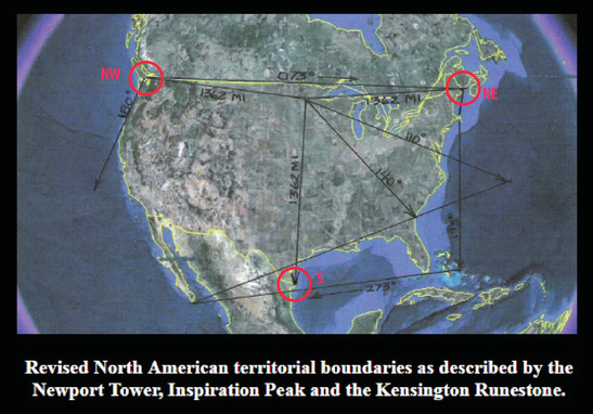
Faram's figure showing 1362 mile distances from Inspiration Peak, MN, to the boundaries of the United States; markers for the NW, NE, and S corners added (original from www.thekensingtonrunestone.com)
Faram provides latitudes and longitudes for both Inspiration Peak and the "three corners," making it simple enough to perform distance calculations. Here are the results that I got using this online tool: ​
Picture
Picture
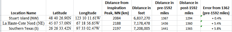
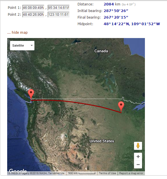
The distance from Inspiration Peak, MN, to the Stuart Island coordinates provided by Faram is 1367 pre-1592 miles.
Picture
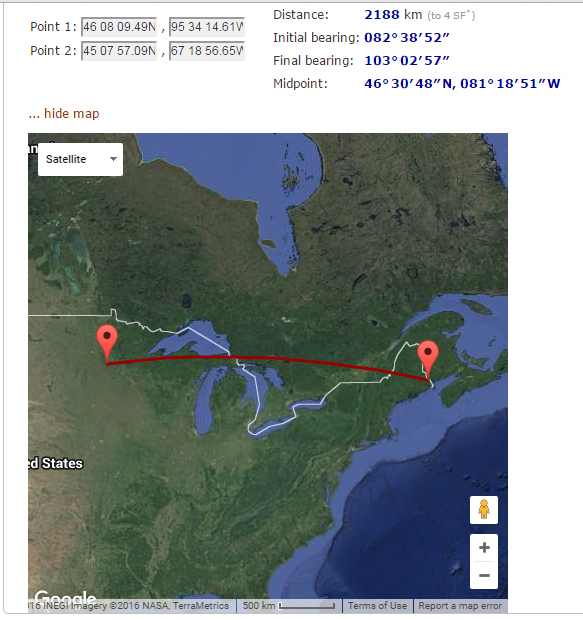
The distance from Inspiration Peak, MN, to the La Haute-Cote Nord coordinates provided by Faram is 1436 pre-1592 miles.
Picture
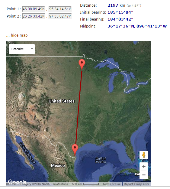
The distance from Inspiration Peak, MN, to the South Texas coordinates provided by Faram is 1441 pre-1592 miles
None of the distances between the pairs of coordinates he provides is "exactly" 1362 miles, and the distances to the NE and S points aren't even close in pre-1592 miles (i.e., when a mile was defined as 5,000 feet rather than 5,280 feet).  The claim that Inspiration Peak, MN, is an equidistant 1362 miles from those three boundaries of the United States is demonstrably false.

The issue of why the length of the mile was changed from 5,000 feet to 5,280 feet in the late 1500's is an interesting one (you can read one take on it here and another here). Faram asks if the change was made "to mask all the measurements done before" 1592, hinting at a mapping conspiracy that could be easily overcome by a change in division.

One of the strangest ideas embedded in Faram's treatment of the KRS is that the number "1362" stands for both the year the stone was created and the distance measurement to each of the three corners of of the territory. Peculiar on its own (in 1362 a party journeyed to a point 1362 miles equidistant from opposing coasts and carved on a rock?), it becomes bizarre when you factor in Faram's claim that the lower portion of the writing, including the number "1362," was an amendment to the stone that was actually added after 1519.  So the original stone was placed 1362 miles from the opposing coasts in 1362, but the number "1362" was not added until much later? And, coincidentally, the third (southern) point that was added to the claim was also 1362 miles from Inspiration Peak, even though it was an amendment?  What good would the original marker have been without the date/distance recorded on it? And how would the carvers in 1362 have known that they needed to place the stone in a location 1362 miles from a point on the southern boundary of the territory which had not yet been defined? You almost need to invoke time travel to make the claim reasonable.

But these gymnastics don't matter, of course, since Inspiration Peak is not actually 1362 miles from the points that Faram specifies.

As usual, let me know if I've gotten anything wrong. I'm happy to fix errors.
16 Comments
Joe Scales link
6/18/2016 08:47:23 am

Two rune carvers for the KRS is not a new, nor original allegation. When the "Gran tapes" came about, it was alleged that Ohman and his neighbor Gran together carved the stone and then buried it to later perfect their prank. This version you can find on the Viking Answer Lady's page: http://www.vikinganswerlady.com/Kensington.shtml

I'd also read... but forgive me, I don't have the source at this time... that at least one investigator found two distinct styles of carving in the runes, and further concluded that one was right handed and the other left handed. Like Ohman and Gran. Allegedly...

Reply
Andy White
6/18/2016 11:37:06 am

Thanks for the references, Joe. I'm looking at them now.

Reply
Andy White
6/18/2016 12:50:41 pm

I've added a link to a follow-up post:

http://www.andywhiteanthropology.com/blog/right-and-left-handed-rune-carvers

Reply
Ed Tillman
8/6/2022 04:23:00 pm

I to believe that the KRS is a survey marker but its location is off because it was moved from where it was originally placed. It,s my believe it was placed near a 45 degree north location to set claim to the entire northern half of the western hemisphere.
This is one stone there was another that was cut from the bottom of the KRS that was set at 100deg 19 min W that set Pierre S.Dakota and it too was found in 1738 by V'erendry father and son team. Come to be known as the V'erendry Rune Stone VRS that sone gave geographic locaton to where the KRS was place and the KRS did the same for the VRS. Two stones one for center longitude and the other for center latitude both telling where the other was place.
The VRS location was mention on the following rune stone other then the KRS. They are the Narragansett Rune Stone NRS, The Heavener Rune Stone HRS and the Independence Rune Stone IRS
for those coming from different direction I also believe there to be another one in the state of Washington.
The IRS gives location of another most interesting place the Adem-ondi-Ahman AOA. That's right all these stones are connected to the Mormons and the Church of the Ladder Day Saints. The AOA was to be the original longitude reading but was change after the Treaty of 1494 with Spain and Portugal moving the extremities of the Atlantic part of the claim to 30 Degrees W.,that originally took in the Azores Islands at 24.5-31.5 deg.West. moving the AOA reading of 94 deg. to the area of VRS at 100 deg 19 min. these two stones was to mark the center of Zion the New Jerusalem.
It is also interesting to note that this event was to take place right before Rogation Day. Under a sign from God a spectacular comet whose vapors cross the heavens that started on March 5 1362 this comet is called Swift-Tuttle.
This one comet appeared over and over again in the life of the Jews in their Quest to come to the Promise Land From the time of the destruction of Solomon's Temple in 587 BC. to the forming of James Town 1607 AD.
Other dates that they showed up was in 459 BC when The prophet Nedemiah rebuilds walls and people leave Babylon,332 when Alexander the great takes control of Jerusalem,200 the Seleucid Empire takes Jerusalem and Judah people heads to Europe,69 BC second temple destroyed,66-67 AD James the Just killed and Jewish revolt starts, Roman Empiror Decius persecute Christians, 312 AD Constain sees cross,China people starts migration the start of the end of the Hopewell Nation (Jaredites),451 Attila attacts Rome Empire some leads here head back to Europe,573 AD Mayans starts new calendar, 700 Newcomers meets in S.west area of Tucson Artifacts, 838 war starts with the Mound Builders,972 Aztecs, 1090 Crusader monks leave for Rome,1226 Great Tempest dated 34 AD in Book of Mormons,1362 Kensington Rune Stone set carved the prior year,1492 Columbus and Full Venus Cycle,1607 Jamestown and Moroni buries plates this is a converted date that is 415 AD in the Book of Mormons.
This information comes from my book called Heaven Holds the Answer by E.G.Tillman that can be bought at Amizon paper or E-Book or by me paper only 1-660-258-3951.

Reply
Ed Tillman
8/6/2022 06:52:38 pm

Correction on the prior post. Toward the bottom of 3rd par. it says "after the treaty of 1494 with Spain and Portugal" it should have said "after Greenland,Iceland,England and other islands became a part of Europe in 1300 AD"

Peter Geuzen
6/18/2016 09:06:53 am

"Upon submitting the runestone to a handwriting analysis...."

I know that all of my runestone carving matches my handwriting exactly. It was the way I was taught, so he might be on to something IMHO.

Reply
Uncle Ron
6/18/2016 11:14:33 am

So now the carvers of the KRS didn't just make it to Minnesota, they traveled (and apparently surveyed) the entire area of what would become the United States and part of Mexico? This is just high-tech numerology. SOMETHING is 1362 miles from everything.

Reply
Ryan Howell
6/18/2016 12:04:27 pm

The Kensington Runestone is Minnesota's historical who-dunnit. Probably the best, open-minded and yet scientific text is that written by Alice Kehoe a grande-dame of Wisconsin Archaeology. https://www.waveland.com/browse.php?t=117

Reply
Joe Scales
6/20/2016 07:52:37 am

Unfortunately, Kehoe accepted Wolter's self-published work as "hard data", when you're not even going to find another living geologist with a PhD to concur with same. Kehoe actually wrote suggestions to Wolter when he was self-editing his book and implored upon him to avoid the Dan Brown garbage so as not to discredit his other findings. He of course ignored her.

Reply
Jean Stone
6/18/2016 12:16:28 pm

Here's where our good friend Occam is of great assistance. What explanation makes more sense: That the stone is a hoax and any and all oddities can be explained as such, or that it's a coded document that's supposedly establishing an important claim, but in the most roundabout fashion which can be read in whatever way the reader wants to (look at the different ways people interpret it) and in the end the numbers still don't add up...

Reply
Mike Morgan
6/18/2016 10:33:46 pm

Arthur Faram isn't alone in a having a "1362 mile" theory, Paul Stewart does also. I have not looked into his theory beyond his posts and comments in your "Fraudulent Archaeology" group made on and after May 25th, but from those I have gathered that he absolves Olaf Ohman of the carving of the runestone and believes that it was carved by a group of "Cryptic" Masons/Freemasons sometime in the mid to late 1800's.

Some of Paul Stewart's comments:

"Using 19th century maps, extend a protractor 1362 miles and trace a circle using the location of the KRS as the needlepoint, and you see that it too is located in the "center" of continental America, if one is measuring to its "cardinal" points (again, see earlier attached)."

"If I take maps from the 1800s and place the point of my protractor at the site of the Runestone founding and extend the protractor outwards 1362 miles, it produces a circle which touches the western, southern and eastern points of the continental USA; a boundary not determined until the 1840s...and a measurement made in miles."

https://lookaside.fbsbx.com/file/1800s%20Maps%20of%20USA%20with%20text.pdf?token=AWydYJxI89r9A2VF2DbhPtMnTzDNGrzhrGf7naacENo5FV8MSFWjMrqn19pg7l_BdOHjv9oEWjfpviccScl3F_U78Ieyr73j0NnO64P2Q52CfboCg56j9nVna3xZoprWvmv16SjMt3yVQC1wPjyj5KgL

"Thus, I believe the Kensington Rune Stone, located in the "center" of the US, was a secret and enigmatic way to claim a cryptic hegemony over the country (a message intended for other Masons)."

I have a feeling you may have missed the rather lengthy discussion. On May 27th, someone posted:
"So I am going to have a go at Protractor Archaeology later. I can not find anything in my text books, nor have I heard anything in my lectures." and you replied:
"What is "protractor archaeology"?"

If interested in finding more about his theory, you may want to read Mr. Stewart's book, "The Enigmatist: Book I - The Runic Mysteries". Or just see our friend, Jason Colavito's review: http://www.jasoncolavito.com/blog/new-book-claims-kensington-rune-stone-is-part-of-an-elaborate-freemason-numerological-code-and-hoax

Reply
Tom Rent
6/20/2016 04:27:18 am

Paul Stewart is on the right track. For a Century researchers claimed it was Ohman or it was authentic Norse. Paul and a few others felt it more likely was done in the settlement period (late 1800s) and for another purpose entirely (not a hoax). After looking at many possibilities it was the excessive use of numbers on the stone that started to stand out. It was as if the numbers were what was important and the odd/ridiculous story was just filler. A huge spreadsheet was created of possible culprits and over the course of 2 years only one person was identified who fit the evidence - he was a land surveyor, the head of the MN Cryptic Rite Masons, and a Masonic "numbers" nut. By adding up all the numbers as individual digits on the KRS, the value is 33. The number of runes on the KRS is 222, a sacred Masonic number. 666 and 696 are sacred Masonic numbers ... add them up it comes to 1362. With a flat map of the USA in 1870, Kensington is located exactly 1362 miles from the 3 corner border points of the lower 48 in Washington, Maine, and Texas, so this location was "sacred" to the Masons and, at least this local Masonic group, wanted to place a encoded stone that would intrigue the locals if found and be preserved, when in fact it had a secret Masonic purpose of "claiming" a Masonic origin of the USA, similar to Masonic symbols used in the layout of Washington DC. Most of the USA's early founders were Freemasons. This is just a small sample of the Masonic origin of the KRS, much more is in Paul's book. The most recent discovery is the 1885 Beale Papers that talked about a huge buried Treasure in Virginia uses the same number sequences as the KRS and has now been linked to the Virginia Cryptic Rite Masons. They "entertained" themselves or challenged each other with numeric and textural material that the average person would not "see" when they read them. They would fall for the story, when in fact it was the numbers that told the real story. Masons have a saying "We hide the real truth in plain site." It's amazing it took until recently for this Masonic origin to be researched. That said, the evidence is still circumstantial. We haven't found a clear smoking gun as Masons even today are pretty good at keeping their activities secret. The practices in Freemasonry are complex and go back many centuries. Only through studying and understanding these does the late 1800s origin of the KRS (and the other American runestones) become clear as being the work of the Cryptic Rite and possible just one person in that Rite - Minnesota's Cryptic Rite leader George W. Cooley. Before you dismiss the idea, read Paul's book and you'll appreciate the thought process and discoveries leading up to the hypothesis. As an Art major who has chiseled in rock, the left/hand right-hand aspect is easily explained.by Paul.

Reply
mangarockapk.info link
9/11/2018 03:30:50 am

This is the right blog for anyone who wants to find out about this topic. You realize so much its almost hard to argue with you (not that I actually would want?HaHa) Great stuff..

Reply
192.168.l.l link
5/20/2020 02:42:33 am

This is my first time pay a quick visit at here and i am actually pleassant to read everthing at single place.

Reply
Ed Tillman
9/29/2022 12:25:36 am

The date of 1362 is a bit deceiving. In 1585 or about we was introduce to the calendar reform, that made Jan 1st the new New Years Day. In 1362 New Years Day was March 1st. The KRS was carved for 1362 in 1361.
Its my beliefe that the bottom of the KRS produce the rune stone that would be known as the V'erendry's Rune Stone VRS that was sent to France. It too was carved for 1362 in 1361. Although we do not have this stone because it was loss in a WW II bombing raid. This stones measage may have been the same as it's possible mock-up, the Spirit Pond Rune Stone SPRS. Both stones KRS & SPRS have geograghic readings with-in the runes that tells where the other stone was set..
Their counter part rune stones even though they are made up of different types of runes, are done so, to give clues on what system of decipherment is needed for that one stone.
Therefor the Heavener HRS,Narragansett and the Independence Rune Stone thats believed to have been carved in 1888 was not, they was all carved for 1362. Under the sign of God the 1362 Swift-Tuttle Comet whose "curved vaper cross the heavens" on March 5 1362. This comet was seen for several months before this. The name Heavener may have came from this event.
The bottom of the KRS has a dimension that appears to match the dimensions of the VRS from the reports. 4"X13"X5".
These stones was all carved around the same time. To set claim to the northern half of the western hemisphere from pole to equator in the name of God under his all seeing eye, Swift-Tuttle Comet.
The given hidden date on the HRS has a date 1362 on it and the SPRS occording to Runologist Richard Nielsen it has an amalgamation of two diverse rune rows, one with date 1362
In Norway two things happend, one King Hakkon is crowned in Feb, the last month of the year witch places him here in March, and Norway gives up Vinland (Americas) as loss. They became the property of God.
Those that was envolved in this was later called the Mormons.

Reply
Ed Tillman
9/29/2022 04:07:21 pm

I failed to show how the Narragansett rune stone fell in to play with the possible date 1362. This stone also has a geographic reading in its scrip that leads to the VRS placement. And the date may have been found to the left of the rune for "S". This area of the rune stone is damaged. But there is still some evidence on what it might have been.
Those Runeologist that look at the stone after it came out of the water and for the first time was able to study this rock in a dry and clean condition. Notice some marks that extended out from the damage area, and came to the conclusion that it was once a possible "asterisks" a star.
Runoligist James Frankki stated;"Each rune could have stood for just a letter, a number, an entire word, or a concept. They were rich with symbolism, and interpretation of each symbol usually depended on some of the symbols around it."
With that I wanted to look at the second rune in the Narrigansett Rune Stone that follows the rune for "S". This rune looks like an anterisk on steroids. The diagonal lines are on the wrong angel for a final finish "H" and they are not long enough for a final finish "G" those lines are to come to the same elevation as the top and bottom
of the vertical line that they intersects. So what is it? How about an asterisk another star. In the name Americas there is a name of a star or planet whose name is Merica aka Venus. Merica was also known as The Promise Land. The old European spelling for Americas was Amerikas. The rune that I call the sacred X that Scott Wolter call the Hooked X can stand for God in the Futhark method of translation. God's Promise Land, God's Merikas- A-Merikas-Amerikas. So the
steriod asterisk after the "S" could stood for "E" the second letter in Merika to be the second letter in the rune stone to spell out its own name in its anagram form.
So it also possible that the symbol asterisk before the "S" could also be a "star" but only a star but a special star, a travelling star that they held sacred. The comet of 1362 Swift-Tuttle whose "curved vapers cross the heavens" it was overhead and been seen for months before this.
The Narrigansett Rune Stone also has Gods sacred X the same as the KRS and the SPRS. I beleive that this Sacred X was used to tell what method of decipherment was used on those stones to show claim to the northern half of the western hemisphere in the name of God.

Reply


Leave a Reply.


    All views expressed in my blog posts are my own. The views of those that comment are their own. That's how it works.

    I reserve the right to take down comments that I deem to be defamatory or harassing. 

    Andy White

    Follow me on Twitter: @Andrew_A_White

    Email me: andy.white.zpm@gmail.com

    Enter your email address:

    Delivered by FeedBurner


    Picture

    Sick of the woo?  Want to help keep honest and open dialogue about pseudo-archaeology on the internet? Please consider contributing to Woo War Two.
    Picture

    Follow updates on posts related to giants on the Modern Mythology of Giants page on Facebook.

    Archives

    January 2023
    January 2022
    November 2021
    September 2021
    August 2021
    March 2021
    June 2020
    April 2020
    March 2020
    January 2020
    December 2019
    November 2019
    October 2019
    September 2019
    May 2019
    April 2019
    January 2019
    December 2018
    November 2018
    October 2018
    September 2018
    August 2018
    July 2018
    June 2018
    May 2018
    April 2018
    March 2018
    February 2018
    January 2018
    December 2017
    November 2017
    October 2017
    September 2017
    August 2017
    July 2017
    June 2017
    May 2017
    April 2017
    March 2017
    February 2017
    January 2017
    December 2016
    November 2016
    October 2016
    September 2016
    August 2016
    July 2016
    June 2016
    May 2016
    April 2016
    March 2016
    February 2016
    January 2016
    December 2015
    November 2015
    October 2015
    September 2015
    August 2015
    July 2015
    June 2015
    May 2015
    April 2015
    March 2015
    February 2015
    January 2015
    December 2014
    November 2014
    September 2014
    August 2014
    June 2014
    May 2014
    April 2014
    March 2014

    Categories

    All
    3D Models
    AAA
    Adena
    Afrocentrism
    Agent Based Modeling
    Agent-based Modeling
    Aircraft
    Alabama
    Aliens
    Ancient Artifact Preservation Society
    Androgynous Fish Gods
    ANTH 227
    ANTH 291
    ANTH 322
    Anthropology History
    Anunnaki
    Appalachia
    Archaeology
    Ardipithecus
    Art
    Atlantis
    Australia
    Australopithecines
    Aviation History
    Bigfoot
    Birds
    Boas
    Book Of Mormon
    Broad River Archaeological Field School
    Bronze Age
    Caribou
    Carolina Bays
    Ceramics
    China
    Clovis
    Complexity
    Copper Culture
    Cotton Mather
    COVID-19
    Creationism
    Croatia
    Crow
    Demography
    Denisovans
    Diffusionism
    DINAA
    Dinosaurs
    Dirt Dance Floor
    Double Rows Of Teeth
    Dragonflies
    Early Archaic
    Early Woodland
    Earthworks
    Eastern Woodlands
    Eastern Woodlands Household Archaeology Data Project
    Education
    Egypt
    Europe
    Evolution
    Ewhadp
    Fake Hercules Swords
    Fetal Head Molding
    Field School
    Film
    Florida
    Forbidden Archaeology
    Forbidden History
    Four Field Anthropology
    Four-field Anthropology
    France
    Genetics
    Genus Homo
    Geology
    Geometry
    Geophysics
    Georgia
    Giants
    Giants Of Olden Times
    Gigantism
    Gigantopithecus
    Graham Hancock
    Grand Valley State
    Great Lakes
    Hollow Earth
    Homo Erectus
    Hunter Gatherers
    Hunter-gatherers
    Illinois
    India
    Indiana
    Indonesia
    Iowa
    Iraq
    Israel
    Jim Vieira
    Jobs
    Kensington Rune Stone
    Kentucky
    Kirk Project
    Late Archaic
    Lemuria
    Lithic Raw Materials
    Lithics
    Lizard Man
    Lomekwi
    Lost Continents
    Mack
    Mammoths
    Mastodons
    Maya
    Megafauna
    Megaliths
    Mesolithic
    Michigan
    Middle Archaic
    Middle Pleistocene
    Middle Woodland
    Midwest
    Minnesota
    Mississippi
    Mississippian
    Missouri
    Modeling
    Morphometric
    Mound Builder Myth
    Mu
    Music
    Nazis
    Neandertals
    Near East
    Nephilim
    Nevada
    New Mexico
    Newspapers
    New York
    North Carolina
    Oahspe
    Oak Island
    Obstetrics
    Ohio
    Ohio Valley
    Oldowan
    Olmec
    Open Data
    Paleoindian
    Paleolithic
    Pilumgate
    Pleistocene
    Pliocene
    Pre Clovis
    Pre-Clovis
    Prehistoric Families
    Pseudo Science
    Pseudo-science
    Radiocarbon
    Reality Check
    Rome
    Russia
    SAA
    Sardinia
    SCIAA
    Science
    Scientific Racism
    Sculpture
    SEAC
    Search For The Lost Giants
    Sexual Dimorphism
    Sitchin
    Social Complexity
    Social Networks
    Solutrean Hypothesis
    South Africa
    South America
    South Carolina
    Southeast
    Stone Holes
    Subsistence
    Swordgate
    Teaching
    Technology
    Teeth
    Television
    Tennessee
    Texas
    Topper
    Travel
    Travel Diaries
    Vaccines
    Washington
    Whatzit
    White Supremacists
    Wisconsin
    Woo War Two
    World War I
    World War II
    Writing
    Younger Dryas

    RSS Feed

    Picture
Proudly powered by Weebly