I've been working on compiling a database of radiocarbon dates from the Eastern Woodlands. While my interest in doing this is mainly driven by my own research goals (the driving force right now is my desire to be able to discuss the possible abandonment of portions of the Southeast at the end of the Early Archaic period in a symposium I'm pulling together for the 2016 SEAC meetings this fall), I know these data will be useful to others as well.
Here is a GIS map showing the counts by county of the first 4,870 dates that I've gotten plugged in:
Here is a GIS map showing the counts by county of the first 4,870 dates that I've gotten plugged in:
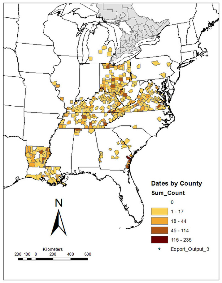
I started with a spreadsheet sent to me by Shane Miller and combined it with data available online from PIDBA (both of those sources were focused on dates from early sites across the east), the Louisiana Division of Archaeology, the Virginia Department of Historic Resources, the Kentucky, Ohio and West Virginia Radiocarbon Database (Cultural Resource Analysts, Inc.), a list of Tennessee radiocarbon dates (Tennessee Archaeology Network), and A Comprehensive Radiocarbon Date Database from Archaeological Contexts on the Coastal Plain of Georgia by John A. Turck, and Victor Thompson. After combining these datasets into a single database (which took some effort), I did a sweep to eliminate redundancies and flag obvious errors. I added a column for county and linked that to a separate table of county names attached to UTM coordinates of the approximate center of the county. That lets me query the database to spit out a table containing a listing of dates and associated UTMs. I imported that into GIS and then did a "join" to count the number of points per county. Voila.
There are still numerous errors and omissions in the database as it currently stands, which is why I'm not prepared to supply the raw data at this point. I've got many dates that are missing key pieces of information (error, site number, county, etc.), and the columns for references are a total mess at this point. As I work through the process of cleaning all that up and trying to fill in blanks, I'll be adding new data. I know of some print publications that will help me fill in some of the large blank areas, and I suspect there are other online or electronic sources of data out there. I've got the UTM coordinates for the counties in most of the Midwest and Southeast (I still haven't done Mississippi and Florida), but I haven't yet started on the tier of states immediately west of the Mississippi River (Arkansas, Missouri, Iowa, and Minnesota) or the Northeast and New England.
There are still numerous errors and omissions in the database as it currently stands, which is why I'm not prepared to supply the raw data at this point. I've got many dates that are missing key pieces of information (error, site number, county, etc.), and the columns for references are a total mess at this point. As I work through the process of cleaning all that up and trying to fill in blanks, I'll be adding new data. I know of some print publications that will help me fill in some of the large blank areas, and I suspect there are other online or electronic sources of data out there. I've got the UTM coordinates for the counties in most of the Midwest and Southeast (I still haven't done Mississippi and Florida), but I haven't yet started on the tier of states immediately west of the Mississippi River (Arkansas, Missouri, Iowa, and Minnesota) or the Northeast and New England.


 RSS Feed