Andy White Anthropology
  • Home
  • Research Interests
    • Complexity Science
    • Prehistoric Social Networks
    • Eastern Woodlands Prehistory
    • Ancient Giants
  • Blog
  • Work in Progress
    • The Kirk Project >
      • Kirk 3D Models list
      • Kirk 3D Models embedded
      • Kirk 2D images >
        • Indiana
        • Kentucky
        • Michigan
        • Ontario
      • Kirk Project Datasets
    • Computational Modeling >
      • FN3D_V3
    • Radiocarbon Compilation
    • Fake Hercules Swords
    • Wild Carolina >
      • Plants >
        • Mosses
        • Ferns
        • Conifers
        • Flowering Plants >
          • Grasses
          • Trees
          • Other Flowering Plants
      • Animals >
        • Birds
        • Mammals
        • Crustaceans
        • Insects
        • Arachnids
        • Millipedes and Centipedes
        • Reptiles and Amphibians
      • Fungi
  • Annotated Publications
    • Journal Articles
    • Technical Reports
    • Doctoral Dissertation
  • Bibliography
  • Data

Minnesota Stone Holes and the Boulder Field Quarry Hypothesis: I Dare You to Prove it Wrong

9/25/2016

100 Comments

 
At the risk of stepping in it (again), I'm writing another post about stone holes.

You heard me: stone holes.

My last post on the subject asked why we should assume that hand-chiseled holes (which are irregular or triangular in shape rather than perfectly round) are medieval in age. There are several pieces of information (including experiments and first-hand accounts) that leave little doubt that the hand-chiseled holes being created in Minnesota in the 1800's and early 1900's would be difficult to distinguish from any holes left by a Norse expedition hundreds of years earlier. The discussion on that post didn't convince me that there's a good positive case to be made for the medieval origin for any of the stone holes: the work to develop and apply a reliable methodology for discriminating stone holes based on their intrinsic characteristics apparently hasn't been done yet.

I thought it might be fun to approach the problem from the other direction: let's develop a falsifiable hypothesis that all of the stone holes are of modern (i.e., post-Columbus) origin. I'll call it the "Boulder Field Quarry" hypothesis. I didn't invent this explanation, of course, but considering it as a formal hypothesis will be a useful way to demonstrate how you use an explanatory model (an explanation/description of how variables fit together) to derive falsifiable expectations that you can compare to empirical data. If it's possible to prove a hypothesis wrong but you can't do it after repeated attempts, you can start to have some confidence that you might be onto something. Here it goes.

Hypothesis: All of the stone holes found on boulders in Minnesota were produced by post-Columbus Euro-American settlers for the purposes of blasting the boulders into smaller pieces. 

Glacial boulders in Minnesota were useful sources of stone for the Euro-American who populated the region in the 1800's. Holes chiseled or drilled into boulders were packed were filled with black power, gun powder, or dynamite. The explosives were ignited to break the boulders into smaller pieces which could be removed to clear fields and/or be used as building materials.

In The Art of Splitting Stone: Early Rock Quarrying Methods in Pre-Industrial New England 1630-1825 (2005), Mary Gage and James Gage discuss how this technique was used by German immigrants to New England in the late 1700's and early 1800's (pp. 24-25). Gage and Gage (pg. 25) describe round blasting holes with a diameter of about 1 3/16" (about 3 cm) and depths ranging from 4 to 20 inches (about 10-51 cm). New England blasting holes created after 1825 are slightly larger, ranging in size from 1.5-2 inches (3.8-5 cm) (pg. 25). Gage and Gage also note that "Generally, the hole was drilled into the top center of the boulder . . . Some surviving examples of blasted boulders have two or more blasting holes. The evidence indicates that an additional blast hole was drilled when the first blast was insufficient to break the whole boulder apart" (pg. 25).

Text Expectations: The placement, diameter, and depth of stone holes in Minnesota should be consistent with their creation for the purpose of blasting rocks. Based on descriptions of boulder field quarry blasting in New England discussed by Gage and Gage, the following statements should be true: 
  • Boulders with one or more stone holes are too large to easily move in one piece or too large to use in the construction of building foundations;
  • Stone holes are located on the top surfaces of boulders in locations suitable for blasting the entire boulder or removing significant pieces of the boulder;
  • Stone holes are in the range of 3-5 cm in diameter;
  • Stones holes are in the range of 10-60 cm in depth;

The test expectations are pretty simple. They can be refined if there's additional information out there about patterning in stone holes associated with boulder field quarry blasting.

​In the comments to the previous stone hole post, I mentioned repeatedly the need for a stone hole dataset that could be analyzed. This is why. The boulder field quarry model produces specific expectations for patterning in the placement, size, and depth of stone holes. In other words, it makes predictions which can potentially be shown to be false. Testing those predictions requires empirical data that can be used to quantify and characterize the stone holes. How wide are they? How deep are they? Where are they located on individual boulders? Are there any examples of small, intact boulders with stone holes? 

Can the "medieval Norse origin" stone hole model produce a set of falsifiable predictions? I don't know. If so, I have yet to see those predictions clearly articulated.

That's one reason why the boulder field quarry hypothesis should be the null hypothesis.  There are several others: it accords with multiple first-hand accounts, it's logical, and it fits with experimental, archaeological, and historical data from other areas. If you can prove that the stone holes weren't for blasting, I'm prepared to consider alternatives. But first you either have to show me why this explanation doesn't work (citing "because the Kensington Rune Stone" exists isn't going to cut it, either, for reasons I've already beat to death) or develop an alternative model that's also falsifiable. What characteristics of these stone holes indicate they weren't created for blasting rocks?
Picture
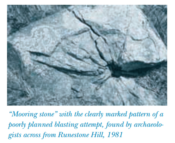
Figure from Tom Trow's "The "Mooring Stones" of Kensington" (Minnesota History, Fall 1998; http://collections.mnhs.org/MNHistoryMagazine/articles/56/v56i03p120-128.pdf)
100 Comments
GEE
9/25/2016 01:01:32 pm

I learn something new everyday from you Andy. Blasting, the boulders for other uses makes perfect sense. thank you

Reply
Judi Rudebusch
9/25/2016 03:00:55 pm

well, I am 'next door' to MN- and in one area of NE SD, there are over 70 such holed stones. Not one hole is 13/8 in diameter. Just as a suggestion Andy, can you put splitting of stone in the works, too? Many rock were split by use of a chisel, not needing to blast. In conversation with our State Archaeologist, Mike Fosha, he did bring up an interesting thought on blasting and it's effects on granite rock--blasting would -by means of the concussion- create small fissures throughout the rock. Rock broken this way would make poor building material because of the moisture that would accumulate in those fissures causing *down the road* a crumbling rock- not suitable for example- foundation stones. Blasting with dynamite is different than blasting with black powder. Historically, certain men could 'read' the veins or mineral patterns in a rock and split them by hitting them the right spot. Yes, since 1998 when I started with the holed stones- I have been campaigning for a way to do a weathering ratio analysis on these holes. What we have, that you do not have, is the 'ethno history' of the people in the community who talk to us about the area/holes.

Reply
electric scooters seats link
2/17/2020 10:38:14 pm

If you are trying to come to a decision about which type is best for you personally, it normally comes down to speed and money. If you are traveling long distances and need higher top speeds it is almost a necessity to get a gas powered scooter.

Reply
Jim
9/25/2016 03:28:30 pm

Andy, I might question this.

"Stone holes are located on the top surfaces of boulders in locations suitable for blasting the entire boulder or removing significant pieces of the boulder;"

The shape of the boulder may come into play here. For instance an exaggerated egg shape, with the narrowest part at the top would make that point a poor blast location. Also if they were blasting for building material different locations may make more sense, again taking into account the shape of the boulder.
The expertise of the blaster comes into play here as well. Did they, have any mining or other explosives experience ? We do not know this, but placement and depth of holes would surely be be hugely different depending on experience
A deeper hole might leave room for packing or a plug to be put in front of the explosive to help contain the energy inside the rock. On shallower holes a simple bladder of water would have the same effect. The difference from an open hole to a stopped hole is huge in regards to energy retention. Points to ponder.
For the record I have blown up tons (and I mean that literally) of explosives. Never blown up a rock though. You can buy "rock crushers" now from explosives companys that are shape charges, no drilling needed.

Reply
Judi Rudebusch
9/25/2016 03:51:11 pm

this is all presuming that these boulders are all up, and out of the ground- they are not. Blasting might only sheer the top portion off and the best an early farmer could do is farm over it better. One stone, for example, on a man's farm was completely covered with soil- in a side hill pasture area. In 1950's, they decided to break this pasture land up. Each year as they farmed the new breaking, they broke digger shanks on a huge boulder under ground. They called a man with a large 'cat' to come out and dig this rock out- then they put it down in the treeline out of the way....there is a hole in it on top, about 5 inches deep. We have 2 instances of a rock being taken out by Irwin Annette, put into treelines with the hole up. I called Mr. Annette after hearing the story from the land owner, and he remembered taking that rock to the treeline. He did not make the hole...who did is the question.

Reply
Andy White
9/25/2016 03:54:59 pm

Could someone earlier have tried (unsuccessfully) to fracture it so they could remove the top?

Jim
9/25/2016 04:46:33 pm

Judi, There is certainly no logic to blasting a rock you can't remove anyway. It would only make it less visible and more prone to breaking farm equipment on. So (speculation) a seat for a marker pole that could be flagged? A marker for a farmer to avoid with his machinery. Or if not the farmer, a location marker or route marker ? Certainly makes sense. Are most of these holes on the top and mainly vertical ?

Judi Rudebusch
9/25/2016 05:24:53 pm

Jim- no, they are not all vertical, as seen by photos I just sent to Andy. I have given him permission to put up any he choses. Some here think that these boulders are free standing up and above the ground- many to most are 80 percent or more under ground today. many, are on hillsides where natural prairie grass is still today- never farmed, nor farmable. One thing to remember about blasting- you better know how to use it- or you are picking up shards of razor sharp pieces of rock that could cut your hands.

Jim
9/25/2016 06:35:02 pm

Judi, Thanks, that paints a clearer picture.

Andy White
9/25/2016 03:53:18 pm

Judi and Jim,

Thanks for comments. You have both brought up things that could be incorporated into the boulder field quarry hypothesis.

I agree that the boulders could have also been reduced by controlled splitting using wedges placed in chiseled holes. My understanding is that such methods often utilize shallow holes placed in straight lines - does that line up with any of the stone hole sets you know about, Judi?

As far as breaking the rocks just by hitting them, I know that it can be done. There would surely be some kind of size threshold above which that wouldn't work, however. I have some anecdotal evidence from watching experienced workmen split rocks during a cave excavation I participated in in Montenegro. For rocks below a certain size, they would break them with sledge hammers and prybars. Above a certain size, however, they would have to drill holes to blast them with dynamite. We'd work around the big ones until we couldn't work anymore, then they'd come in with a gas-powered drill to create the holes, pack them with explosives, and blow them to pieces so they could be removed.

We certainly do have accounts of people saying they created holes to blast the rocks (such as in the Trow article), so we know it happened that way at least some of the time.

Reply
Judi Rudebusch
9/25/2016 04:19:56 pm

Andy, just emailed you some photos of what 2 moldings of holes in my area look like. You can put them up, if wanted.

Reply
Judi Rudebusch
9/25/2016 04:33:02 pm

Andy, just sent you pics of worked stone in Ohman basement. One can see many chisel marks on the stone for working the rock- I call them bevels- you are seeing what a hole in the stone looks like after it is broken open- like a sandwich. One hole is very rounded.

Judi Rudebusch
9/25/2016 04:23:51 pm

I have seen a few rock that have the plug/feathers work done on the top of the rock for a straight split. One hole, though, has in some cases, caused splits going out from the three edges, like a pie cut.

Reply
DuVal Lawrence
9/25/2016 04:46:45 pm

I have heard/seen pictures of several holes drilled in a line, the hole were plugged with water soaked pegs driven tightly. The freeze/thaw cycle then split the stone sling the line of holes. Thought that was cool when I saw it.

Reply
Gunn
9/25/2016 10:36:27 pm

Hi DuVal, at this webpage you will see two photos showing what you are talking about. These are modern (late 1800's - early 1900's) small-diameter stoneholes in a row, which were machine-made. Please overlook the great lichen display to see that the holes are "modern" and were perfectly round before a split was made. See the clear, measureable roundness of the cracked-off stonehole. Evidence of a lot of quarrying work is nearby. (Context is everything.)

http://www.hallmarkemporium.com/kensingtonrunestone/id43.html

Now, return back and notice the next two photos. These are of the proposed medieval Norse Code-stone I found last year, one photo a distance shot and one a closeup of one of the holes. Wow! Look how irregular and degraded it is, compared to the crispness of the broken off stonehole.

Thanks for bringing this up. It presented a great opportunity for expanding stonehole knowledge.

Reply
Only Me
9/25/2016 05:54:13 pm

It seems the boulder field quarry model is already getting results. Based on the comments so far, it seems there were various methods for working these stones, limited only by size and material.

This is a long shot, but I found there is one other reason boulders can have triangular holes: tourmaline crystals. The crystals form inside the boulder, creating the triangular shape. Once the surface of the boulder has experienced enough erosion, the crystals can fall out. Of course, I don't expect this occurrence to happen in sufficient numbers to account for even a fraction of the stone holes discovered, but it does occur.

Looking forward to more discussion on this model.

Reply
Tom Rent
9/25/2016 06:22:58 pm

For centuries stone masons chiseled vertical centered holes in stones and then used a split pin Lewis to lift the stone. A common practice even today for headstones too. I suggest this could have been used on farms to yank glacial erratic stones from the ground that were too hard to dig out by hand. They'd use a horse or two, chains, and a split pin Lewis. Look it up. This method might have been more effective to drag such boulders to the edge of fields with no real intent for blasting.

Reply
Andy White
9/25/2016 06:28:34 pm

I just found a cool description of some wagon/hoist device from the 1930's for pulling big stones out of fields. I'm searching through old farming journals now. Like I need one more thing to chase after.

Reply
Tom Rent
9/25/2016 06:36:38 pm

Look up stone boats.

Jim
9/25/2016 06:46:57 pm

Might be useful for moving large metal creatures.

Judi Rudebusch
9/25/2016 06:48:13 pm

Yes, stone boats would work, Tom, but not for the larger boulders. A farm tractor with loader could not lift some of these. The man I mentioned earlier, Mr Annett, came to our farm and dug boulders out of the field that were larger than a pickup by a lot. It took dozer cats to bring them up. So far, I have only one like that with hole in it.

Judi Rudebusch
9/25/2016 06:52:58 pm

dynamite in the old farm journals tells of dynamite to take care of trees, too. In one I have from the early 1900's, told of digging holes around and down beside a boulder- putting explosives down into the holes to bring the stone out.

Judi Rudebusch
9/25/2016 07:03:02 pm

will this come up for you, this looks like the one my Dad had. https://www.google.com/search?q=stone+boats&biw=1231&bih=577&tbm=isch&tbo=u&source=univ&sa=X&sqi=2&ved=0ahUKEwjciv6x96vPAhVG3IMKHQC_A3MQsAQILg&dpr=1.3#imgrc=9DOUXrCurZp8WM%3A

Judi Rudebusch
9/25/2016 06:43:09 pm

Hi Tom- as you have been out to see a small amount of the holed stones in my area- I can see that method working, but only for the loose boulders. Many I showed you were very imbedded in the ground- much like icebergs in water. Waterloo Iowa did make a horse driven rock hauler that had two huge chains on each side of it with large J hooks that grabbed onto a boulder, hoisted up then delivered to the edge of a field. These lines of stone boulders can be seen on the edge of many fields today, some are being buried.

Reply
Tom Rent
9/25/2016 07:07:23 pm

Yes, I recall seeing some holes out your way in "icebergs." We may never know why some of these holes were drilled. What caught my eye when we explored many of these stones is how perfectly centered most holes were.

Mike Morgan
2/23/2018 11:19:25 am

Tom,

Thank you. Your post of 2/23/18 in "The Kensington Rune Stone International Supporters Club" Facebook group offers clarity and support for this possible/probable reason for many of these "stoneholes".

https://www.facebook.com/groups/287262734058/permalink/10156306761354059/

Reply
Robert S Schemenauer
9/25/2016 07:45:18 pm

This seems to be a valid way to approach the topic, Andy. By setting up the null hypothesis to be that all holes were produced for the purposes of blasting the rocks in the post-European settlement period, it makes it straightforward for it to be rejected. All that is required is that one example be found which is demonstrably not for the purposes of blasting the rock.

My suggestion is that people look at a broad range of other possibilities for the drilling of the holes in the rocks beyond mooring, field markers, and aids for moving the rocks. One logical possibility is archaeoastronomy. People moving through the area in prehistoric times would logically ask two questions. Where are we? How do we get where we want to go? These would be answered through astronomical observations. If this was the use for some of the holes, then one would expect the holes to be nearly vertical within a range that allowed for ground movements over the centuries and also for shims to be used in the holes to keep a post vertical. The other thing that one would expect would be that there would be patterns created by multiple holes at a location. These patterns would have astronomical significance. Two holes aligned towards sunrise at the winter solstice in some relevant year, say 1000 A.D., would be suggestive. Five holes in a pattern that defined a central point surrounded by alignments to sunrise and sunset positions at the two solstices would be quite conclusive proof of a use that is not post-Columbus Euro-American blasting. I put this forward as something that people with precise locations for stones with holes may wish to look into, if they have not already done so.

This is an example of a testable way that an alternative can be found to the hypothesis that all holes are post-Columbus Euro-American blasting artifacts.

Reply
Jim
9/25/2016 08:42:29 pm

Robert, The problem I see with that theory is lack of iron tools for the pre Columbus Population. How did they drill the holes ?

Reply
Judi Rudebusch
9/26/2016 03:40:54 am

Jim, the statement that Pre-C;s lacked iron tools: some of the best swords were made during this time, also take a look at the burial goods found at burial sites of that time.

Jim
9/26/2016 12:02:29 pm

Sorry Judi, I guess I wasn't clear here. I meant pre Columbus North American Population

Uncle Ron
9/25/2016 08:32:20 pm


First , I would like to state unequivocally that I am on the side of the Boulder Field Quarry hypothesis. However, your first paragraph says it all. Short of a reliable method of dating a hole one hole looks pretty much like any other. Mooring holes would naturally be chiseled in boulders too large to be easily moved; would be made on the top surface of the boulder; and could be in any range of sizes (60 cm does seem a bit deep but what are the dimensions of known mooring holes). It seems to me that any data you gather will be ambiguous at best. You ask, “What characteristics of these stone holes indicate they weren't created for blasting rocks?” What possible answer(s) can there be?

It would be interesting to know what the distribution of holes is by altitude. Are all of them in locations that would have been at water level in the supposed time periods of European exploration? Do we know what the coastline looked like at those times and do holes group along the various water-level lines?

Reply
Gunn
9/25/2016 08:42:27 pm

Uncle Ron, the mooring stone theory is dead. Holand was clearly wrong in thinking the stoneholes were for mooring ships. He could have used a good geology-friend back in those days. His friend would have explained about the last glacial movement and how the surface of the earth in this region is almost as it was left by the last ice retreat. The water was not high enough in 1362 to consider floating Viking ships to Runestone hill and mooring them! This is the very history-mischief the Alex area is even today supporting, with a "mooring stone" sign at the park, describing Holand's theory.

Uncle Ron, the mooring stone theory has been dead a long time now. Think: marking land and waterways.

Reply
Andy White
9/26/2016 08:16:48 am

Yes, I think it's possible that it could come down to relative dating. From my perspective, "looks old" isn't going to cut it. There will have to be some reliable (i.e., based on clear, repeatable observations and a well-warranted system of interpretation) methodology for estimating relative ages of the holes.

Reply
Gunn
9/25/2016 08:35:06 pm

Sorry I'm coming to the discussion late. I didn't know about the blog heading until an hour or so ago, as I was out exploring the nearby beginning mountains of Colorado, my new home-state.

I think I can help in the immediate conversation, Andy and readers of this blog. You see, we can be very sure of the age of about 30 stoneholes that were created for sure in the 4th quarter of the 1800's. Here is the good news about this: we can be sure of the obvious LACK of weathering on these stoneholes. I have found verifiable proof that such exact stoneholes were used near Glenwood, MN, during the same period of time, to secure tent poles against the ridge wind...the same situation as at the site I found thirty large stoneholes. These late 1800's stoneholes were apparently used by surveying crews, sometimes probably associated with expanding railroads.

My point is that these age-verifiable stoneholes are all well over a hundred years old--about a hundred and twenty-five years old. I'm suggesting that these can be used as a control group of stoneholes for making comparisons to other stoneholes in the region. Here it is, then: the pioneering stoneholes used for blasting should appear about as aged as these thirty examples from roughly the same period of time.

I again suggest that there is an obvious difference is the degree of ageing between these modern stoneholes and the proposed medieval ones...not just a hint of difference.

Also, I notice that the size of rocks being blasted was being considered, above. I would like to point out that the several stonehole rocks I'm claiming are both Norse and used for setting up an encoding of something buried, are SMALL rocks. Each can be lifted up and carried away by two men. The other stonehole rocks in the area (the thirty mentioned from the 1800's) are in larger rocks, mostly partially buried, as Judi talked about. So, my point is that small rocks don't need to be blasted, as I think Andy pointed out.

I will shortly address another key issue brought up, which will involve the characteristics of these stoneholes, indicating that some certainly weren't created for blasting rocks. I will go in-depth into this most powerful determination that some of these stoneholes could not have been intended for blasting rocks, because of their LOCATIONS at the time found. Soon to come.

Andy, I almost can't believe my good fortune that you would set up another blog on stoneholes...already! Just so you know, I've already set up three good example sites showing what I believe are medieval Norse stoneholes. They are on my website, and I've chosen a site near Wilmot, the KRS discovery site, and the Sauk Lake Altar Rock to begin my data-collection of stoneholes for future science to study.

http://www.hallmarkemporium.com/kensingtonrunestone/id45.html

The other two sites and stoneholes are shown on the next two pages.

Reply
Andy White
9/26/2016 08:22:01 am

The boulder with the crack extending from a stone hole - isn't that exactly what we'd expect from blasting? How did the rock get cracked otherwise?

"I have found verifiable proof that such exact stoneholes were used near Glenwood, MN, during the same period of time, to secure tent poles against the ridge wind...the same situation as at the site I found thirty large stoneholes. These late 1800's stoneholes were apparently used by surveying crews, sometimes probably associated with expanding railroads."

Do you have photos of these late 1800's stone holes? What if they appear "unweathered" simply because they were created with a mechanical drill rather by hand with chisels?

Reply
Judi
9/26/2016 08:55:22 am

Andy, the "appearing" is the factor here that can not tell the age of the hole, in my opinion. From the molds made *sent you photos of* you can see that the mold that holds water is more weathered down the sides/bottom. The mold that shows two shelving demarcations, does not hold water past the lower line where I believe the water seeps out of the hole- that leaves it more dry, less weathered to the eye..Eye...that can deceive. The endoscope came in handy out in the field to visually go down into the hole. In the end, it is testing that will go along ways to answer this, but most of us out here that have done the leg work are not connected to university labs and the dollars it takes to do the work. This protocol would benefit many 'wanna be' artifacts as either true or not.

Andy White
9/26/2016 09:33:50 am

Judi, right. So we can think of a simple "tree" of factors that contribute (or might contribute) to the characteristics of stone holes as they appear today. As an example:

1. The nature of the tool(s) used to make the hole: (a) hand chisel; (b) pneumatic drill; (c) rotary drill

2. Weathering mechanisms affecting the hole: (a) freeze/thaw; (b) etc., etc.,

3. Length of time those mechanisms have been operative

If we can confidently interpret the morphology of a hole as indicated it was created by a pneumatic or rotary drill, we can safely say it isn't ancient Norse.

If a hole was created by a hand chisel, we can't use that feature alone to discriminate between ancient (i.e., pre-1492) and modern holes. So you'd have to go to something like relative wear. You'd have to make some kind of apples to apples comparisons of holes in similar situations (tops of boulders, holding water or not, etc.), and you'd have to use information from the geological sciences to develop what you're looking for.

You could certainly use weathering information from holes of known age (late 1800's mechanically-drilled holes) to understand what "new" holes look like. I think looking at the crispness (or lack thereof) around the rims of these hand-chiseled stone holes might be a dead end, since those edges might be battered incidentally during creation of the hole as the chisel wanders. I think you'll have to end up looking at something microscopic (but I can't say what because it's not my field of expertise).

Another interesting thing to do would be to compare the patterning of placement of known "modern" holes with the pattern of placement of hand-chiseled holes. Are they significantly different? If so, how could those differences be explained?

I understand what you're saying about a lack of resources, and I really do admire the effort you folks have put into tracking all of these things down and collecting information about them. It will pay off in the end.

Gunn
9/26/2016 11:48:33 am

Hi Andy. Cracks stemming from stoneholes can result from several conditions or actions, including freezing, lightening, and the weight of "unbalanced boulders" finally causing fracturing. Blasting is only one reason for boulders to exhibit cracking.

In the history of the Altar Rock, over a hundred years ago the 27' by 17' rock was intact, but then a big section broke off by gravity--from a 16" smaller-diameter stonehole.

Good questions about the late 1800's stoneholes. I will now create another page to hopefully upload photos and information related to these stoneholes. I have plenty of photos of the late 1800's stoneholes related to surveying. Keep in mind that I propose that these stoneholes are on the exact same site, intermingled, with the several proposed medieval Norse stonehole rocks on the same site.

We're dealing with surveying from two vastly different periods of time, as will soon enough be able to be discerned by further study of these enigmatic and very worthwhile stoneholes.

Coming up: Large, late-1800's machine-made stoneholes and an old black and white photo showing their use.

Gunn
9/26/2016 02:35:46 pm

Andy, a page in one of Holand's books shows a diagram with several proposed large medieval stonehole rocks, and it shows that the hole was usually not centered, but offset some...at least in these few examples he knew about.

At one point, only about ten stoneholes were known about. Holand was indefatigable in going out into the field to gather data. Though he was wrong about a few things, he is an authentic Runestone Hero to me...a great man for his times. He often slugged it out on his own, without intimidation.

Gunn
9/25/2016 09:11:55 pm

Okay, the best test-case I know of that would help dispel the all-inclusive blasting theory, which doesn't leave any room for medieval Norse stoneholes, in the known history of the Sauk Lake Altar Rock. I took photos of some pages in a book by H. Holand about the history of this huge multi-stonehole rock, and buried in the history is proof enough, I think, that this large rock could not have been the target of potential blasting...it could not have been for these reasons:

http://www.hallmarkemporium.com/kensingtonrunestone/id49.html

Holand was way off-base thinking every Norse evidence was tied in to the Paul Knutsen search party, which were dragging and sailing their boats across the landscape of MN...not the waterscape. It may be difficult to read, but please take the time to read the specific details about the rock's location and history, which will show in regional characteristics that the holes made in this rock were positively NOT for the desired purpose of blasting the rock apart.

Please take special note of the portion that describes how no farms were in the area when the rock was first known about, and rocks could be picked up in the area by the wagon-load...no shortage of smaller stones for building...plus, most all of the building at this early time consisted of using logs and boards, not rocks.

I hope readers will also take the time note that the stoneholes in the Altar rock appear to be EXTREMELY aged, compared to the thirty large, modern stoneholes from the late 1800's that show almost no apparent ageing at all. The degree in the difference of aging is readily apparent, even without sophisticated study.

Also in this continuing conversation, a database could include showing the situations where supposed medieval stoneholes have shown up in direct proximity with other apparent medieval Norse evidences. This has to mean something when it occurs over and over, though I suppose it could be easily dismissed as being merely coincidental.

When do odds become scientific at some point?

Reply
Gunn
9/25/2016 09:34:36 pm

"Hypothesis: All of the stone holes found on boulders in Minnesota were produced by post-Columbus Euro-American settlers for the purposes of blasting the boulders into smaller pieces."

Hypothesis is false. Plus, the large, modern thirty stoneholes on the ridge I described and showed in photos were definitely not made for blasting rocks...none were blasted, plus I proved through local museum research what they were for.

Andy, NONE of the two groups of stoneholes on the encoded ridge were for blasting, which is almost hilarious, because it blasts your hypothesis all apart. (Sorry.)

Reply
Gunn
9/25/2016 09:56:49 pm

I think we need to set up a hypothesis that eliminates the large, sometimes fancy, machine-made stoneholes from the late 1800's, unless you want to use them for comparison to any truly "forgotten about and unblasted" stonehole (singular) from the same pioneering period. Let's try it again, please...having fun!

Gunn
9/25/2016 11:21:15 pm

Andy, I think you may have stepped into it again, indeed.

"...the Boulder Field Quarry Hypothesis: I Dare You to Prove it Wrong."

How about a slight turnaround: "Medieval Norse Stoneholes: I dare you to explain them away."

Maybe Tom Trow or Mr. Colavito would like to publicly reverse themselves on spreading the notion that pioneering Scandinavians were inherently forgetful. Bottom Line: these stoneholes have not been explained away; they've now been better explained through this adventurous blog. Thanks again for taking a chance, Andy.

(Don't forget to wipe off your speckled shoes before reentering your home...are those, like, burn marks or....?)

Andy White
9/26/2016 08:24:12 am

You're thinking backwards. You can't prove something true, only false. So we try to set up the hypothesis in a way that it is possible to falsify it. If you say "all these holes were made by Norse explorers," what evidence would you accept to prove that wrong?

Gunn
9/26/2016 12:12:12 pm

Andy: "If you say "all these holes were made by Norse explorers," what evidence would you accept to prove that wrong?"

First, I wouldn't say "all" these holes were made by Norse explorers. Next, I would accept any evidence that proves this "fringe" viewpoint wrong. What evidence can you provide me to prove wrong, might be a good question. The bottom line is that these many stoneholes cannot be explained away by blasting, as I think I've shown.

Judi
9/26/2016 01:17:08 pm

Gunn, I have been to the Altar site. I am talking standing in front of the stone- the two just in from the left- long long bevel you can see on one--how long of a chisel do you thing that would have taken? These are round if you go by what you can see down the crack. As you said the end piece is broken from a round hole? The neighbors took us out there- at that time, it was Scott, Jewel, and myself.

Andy White
9/26/2016 01:55:48 pm

Gunn,

One of the issues is that there is nothing that proves the Norse origin of the holes that the "boulder field quarry" explanation doesn't catch. I could just as easily assert the remaining holes were made by aliens. At least by first trying to account for as many of the holes as possible as post-Columbian the "mystery set" will be winnowed down. Perhaps the remaining pattern will be explainable by some other post-Columbian behaviors, or perhaps not. But at least you'll know what you're dealing with.

Gunn
9/26/2016 02:01:24 pm

Judi, the history of the Altar Rock is well known, and it doesn't include any round, modern stoneholes. Viable written sources show that the four stoneholes were there in the very earliest of farming days, before the land was cleared. Did you read the chapter I provided by Holand about this rock?

Also, I never said the end piece was broken from a round hole, meaning a modern hole. I frankly don't know what angle you're coming from on this....

Gunn
9/26/2016 02:14:43 pm

Andy, that's a good idea to winnow down and out all the stoneholes which could be considered as being from the "modern period," which would include all the large, often star-shaped stoneholes which are now hopefully seen as obviously from the railroad/surveying days.

Next, any actual hand-chiseled stoneholes left over from intended blasting could be eliminated if it could be shown that the aging is about the same as their cousins-in-time, the railroad/surveying/tent stoneholes. We would have left proposed medieval Norse stoneholes.

Should we now set up another reverse-hypothesis scenario to zero-in on just those stoneholes thought by some, like me, to be authentic to pre-Columbus medieval times? We could include where they show up: near waterways, springs, and often in association with other Norse-appearing artifacts.

Judi
9/26/2016 02:34:12 pm

Gunn, I will also go to my notes on the altar rock...I am coming from any agenda- but I have a hard time seeing people equate Holand and the word 'truth'. He had an agenda- big time. You will also note in his books, that he believed the holes should slant away from water...I did have a question on where you said the Erdahl axe was found--Marion Dahm took us to the Paul Thronson farm and he took us to the spot where it was found... in a tree'd area where there were boulders with holes pushed from the field.. one had a 5 sided hole with chiseled lines radiating from the corners. I have only seen a picture of one other, from Ohio, like this.

Andy White
9/26/2016 02:43:07 pm

Gunn,

Your second paragraph is the important one.

First, I have yet to see a reliable way to estimate the ages of the hand-chiseled holes. I thinks it's theoretically possible to develop a methodology for doing the relative aging, but that hasn't been done yet.

Second, just because a hand-chiseled stone hole wasn't placed for blasting doesn't mean it's Norse. You yourself have given examples of holes used for tent pole holders.

Third, why not aliens? I haven't seen any independent, solid evidence of a pre-Columbian Norse occupation. You need something else to tie the "leftover" holes to the Norse rather than the KRS and wishful thinking of Scandinavian settlers.

Gunn
9/26/2016 03:06:59 pm

Judi, I wish you weren't so harsh on Holand. He was the first inexhaustible defender of the KRS. Sure he was wrong about some things, but he was a bulldog in defending its authenticity.

Here is the article I wrote about my Runestone Hero, H. Holand, in which I describe the circumstances of discovering that Davidson Lake is the mysterious "Lake with two skerries," mentioned on the KRS. (Oh, I almost forgot...you sat in on my presentation in Kensington a few years ago.) I found, thanks to Holand, the location where the Erdahl Axe was discovered back in 1894, and though he didn't know it, the location of the campsite associated with the message of the KRS, was close to where he went to visit the spot where the axe was found a foot and a half deep under a stump two feet across, according to testimony from Old Mrs. Davidson herself...like Ohman, an original owner of the land.

Here is my "Norwegian American" take on my discovery, which includes many details about the sophistication necessary to be able to locate both the finding place of the Erdahl Axe and the Lake With Two Skerries.

Note: My presentation was accepted into the ongoing KRS archives of the Minnesota Historical Society, and a copy is available from me upon request.

http://www.norwegianamerican.com/opinion/hjalmar-holand-runestone-hero/

Gunn
9/26/2016 03:27:09 pm

Andy: "You need something else to tie the "leftover" holes to the Norse rather than the KRS and wishful thinking of Scandinavian settlers."

Maybe Judi would be willing to ascribe many "leftover" stoneholes along the Whetstone River to a medieval period, along with the Norse-appearing carvings...like the deeply etched and very aged-appearing drinking horn, exactly like those seen in Swedish museums showing the same from a medieval period. Andy, luckily, I think this petroglyph is shown in one of your assigned book readings.

Please recall, Andy, that these mysterious stoneholes show up in places other than around the KRS, and in association with other perceived Norse evidences. Judi's home-turf of the Whetstone River represents the best example of Scandinavians coming into the region, marking up desirable spots for future habitation. Many stoneholes are near fresh springwater.

Andy, I'm trying my best to tie some of these "leftover" stoneholes into finding something both medieval and European, buried hundreds of years ago in Minnesota. We should find out what both a medieval code-maker and modern technology has agreed to: a great dig into America's "almost secret" medieval European past.

You the man.

Judi Rudebusch
9/26/2016 03:50:20 am

Gunn, as I do not want to see this topic die, I respectfully address a few points. At the Sauk site: there are two Very distinct round holes in that huge boulder besides the other holes. The star drill accomplished this roundness, and came much later than the flat chisel used to make a more tri shaped hole. In many ways, it is the pronouncement that one side of this questions "knows" what these holed stones are butting heads with the other side that says 'no way' that keeps the question of it's age/reason for being there- from being solved. Can we take the 'we know' part out- and sit down and try and develop a protocol for testing these holed stones??

Reply
Gunn
9/26/2016 12:33:33 pm

Great idea, Judi, about discussing what we know in our hearts to be true...or not.

By the way, though, the Altar Rock has only four holes in it, none of them modern or round. I'm not sure where you got this idea, but I've been to the site several times and I've taken numerous photos on different occasions. Perhaps you are thinking of a different rock. This Altar Rock comes with impeccable written histories that prove this rock could not have been intended as a victim of assault by blasting.

We are even now determining ways of comparing ages of stoneholes, such as I just suggested, about comparing the late 1800's modern-drilled stoneholes with any known examples of stoneholes actually intended for blasting at about the same time. Let's hang in there, looking for accuracy and truth.

In my opinion, solving a history mystery involves comparing what we "know" with what we "know." I do not apologize for knowing something or another. That's what searching is all about...looking for something to "know" about. I think that is what we're all doing here...trying to know something for sure, eventually using science to support our views. There is nothing wrong with the concept that someone may know something someone else doesn't know about. That's why we're sharing here, right?

I butt heads against the wrong views I see about stoneholes or their histories, and I encourage the truths I see. As you know, I'm also an activist who doesn't mind spending hours picketing, nor do I mind spending my own money to advance knowledge. I don't think the changes we want are going to occur unless we're willing to stand up to improper academic "advances" in knowledge. We need to be united in our front, not backing down or being timid. It is my business to defend the KRS and legitimate medieval stoneholes with heart, always being willing to prove-out what I can by persuasion, if possible. Peace.

Tom Rent
9/26/2016 04:13:00 am

Gunn, the challenge is to eliminate stoneholes that clearly have no tie to settlement period activity. The Alter rock holes can't be eliminated from being drilled during the settlement period. If one could find written accounts of stoneholes in the journals of 17th and 18th century explorers, Jesuit missionaries, fur traders, and map makers (ie: Joseph Nicollet) then a case could be made, but to my knowledge there are no such accounts. Taking a position that a wave of Scandinavians arrived then vanished before explorers arrived in Minnesota, and left only stoneholes as evidence, is an eye-roller.

Reply
Gunn
9/26/2016 12:45:51 pm

Tom, did you read the chapter by H. Holand I provided? You just made the statement that the Altar rock holes can't be eliminated from being drilled during the settlement period. You are wrong about this, as you will readily see once you're willing to read the material provided.

I think an "eye-roller" is saying these authentic norse stoneholes were made for blasting, which I'm in the process of proving false. Please go back and read Holand's take on why the Altar Rock could not have been touched by modern chiseling or drilling, with blasting in mind.

Sometimes it takes effort to get real....

Tom Rent
9/26/2016 08:02:01 am

A small sample of the 170+ Stonehole boulders mapped near Kensington. There are likely 1000s unmapped.

http://i67.tinypic.com/abp3eb.jpg

Reply
Tom Rent
9/26/2016 08:06:24 am

Better link ...
http://tinypic.com/r/abp3eb/9

Reply
Andy White
9/26/2016 10:12:50 am

FYI: I put some of Judi's images in another post: http://www.andywhiteanthropology.com/blog/molds-of-minnesota-stone-holes-lightning-post

Reply
Jim
9/26/2016 10:50:44 am

Nice, Thanks, Judi. So Ohman himself used stoneholes to to break rocks for his basement walls. Interesting.

Reply
Judi
9/26/2016 11:35:09 am

Jim, the stone basement shows that rock was split using chisels. again, to make a straight line, you need a line of holes. breaking off straight makes for a straighter wall face. Here is what makes me wonder on these holed stones: the one hole, as Tom mentioned, more than likely centered on the stone. That isn't to say some have holes to the side/and or top, too. Some foundations were laid in rock, not as straight up and down as a foundation with worked rock. On the Ohman farm, there are three such stone in what looks like natural setting. What could they be for? The only thing in a modern sense would be to anchor a corner in a fence. There are a number of holed stones down from the KRS hill..all in what was once upon a time, a fence line. When the water around AVM island was dry, Tom, Robin and I went out to the island. there was a clear row of rock along what was once another fenceline.. there was a rock with a hole...and a few more on the AVM island.

Jim link
9/26/2016 11:29:23 am

Judi, On the closeup of the bisected stone hole preserved in a foundation rock on the Ohman farm, it appears the hole may be along what was an existing crack on the rock to facilitate the break. Hard to tell exactly from the photo, your thoughts ?
I notice the same thing occurs on some of Gunns photos at the KRS site. Is this a common occurrence in other locations as well?


Reply
Jim
9/26/2016 10:17:42 am

I have some questions about the KRS site stones. Bear in mind I have never been there and am basing these on Gunns photos. Also I am going to play fast and loose with some assumptions, so as not to drag this out over multiple posts.

Have these stones been moved to their present location ?
There is a stone with a brown face that looks to have been split off recently, (relatively speaking) the weathering on this face seems to be hugely different from the rest of the stone.
Where is the rest of this stone ?
If it has gone a'missing, was it used as building material, perhaps at the Ohman farm ?

Reply
Jim
9/26/2016 10:28:08 am

Sorry, link.

http://www.hallmarkemporium.com/sitebuildercontent/sitebuilderpictures/RunestoneHill9282010089.JPG

Reply
Tom Rent
9/26/2016 04:09:44 pm

I've mapped all the stoneholes at KRS park. Most are not in their original locations, they are on property and old fence lines. Fear not, because a forensic geologist has used science to prove these stoneholes at the farm create a sacred geometry to help future Norse expeditions locate the buried KRS.

Reply
Judi
9/26/2016 01:37:56 pm

just a thought on the tonnage of rock needed for the basements of the upspringing towns , such as Kensington and even the farmsites- the amount needed for foundations of barns, home, smithies, graineries.. just a thought.

Reply
Jim
9/26/2016 02:26:22 pm

Angular being preferred over bowling ball shape ?

Reply
Gunn
9/26/2016 01:52:33 pm

Andy, here is a rare 1869 photo showing the use of a stonehole for a tent support. Scroll down until you come to "Earliest Glenwood Photos," then look at the 1869 Survey photo. Enlarge if you can, and see the tent post stuck upright in the large rock:

https://popecountymuseum.wordpress.com/page/11/

Please note that this in relationship to both surveying and railroad expansion I contend that the same situation had presented itself near Appleton, MN, also having to do with surveying on a ridgeline, akin to Glenwood in the same general time period.

The truth of the matter is that I had initially looked over the site and determined that some sort of structure was at play, because it was fairly obvious that some of the large stoneholes formed a rectangular pattern indicating such. It turned out to be for tents. If you wish, I can provide you with a photo I took of the Code-stone site showing stakes placed in holes, indicating a building structure pattern, which turned out to be for tents.

Here is a variety of some of the large stoneholes you wanted to see from this period, from the Appleton site, and also alternating photos from the same site, showing closeups of proposed medieval Norse code-stone stonehole rocks at the same site.

PLEASE note that the several small-diameter stonehole rocks with two holes each are fairly small...far too small to intend for blasting....

http://www.hallmarkemporium.com/kensingtonrunestone/id44.html

Reply
Tom Rent
9/26/2016 04:23:18 pm

The vertical post is inside the tent, as it should be. I'm not sure what that that thing is that you assume is a rock with a hole in it, but I'm guessing it's either canvas from the tent front flap or is a dried leaf from a corn plant.

Reply
Jim
9/26/2016 02:45:59 pm

Jeez Gunn,, In the first photo, click on it and click again to enlarge, I think your rock is a bag with a dead turkey stuffed in it, or something.

Reply
Gunn
9/26/2016 03:42:08 pm

Well Jim, instead of clicking on the picture of the ridgeline surveying crew, maybe it's best to go get a magnifying glass. You can see where the tent-ties are pulled in slightly at the post. I can't help it if you see a turkey instead of a pole stuck into a rock. Some things I can't explain.

Reply
Jim
9/26/2016 04:06:24 pm

Seriously, I do not see the tent pole going into a rock ! Why would they do this ? The wind won't move the bottom of a pole ! Why would you want to trip over a rock getting in and out ? To anchor the top guy line I could see.

Gunn
9/26/2016 04:41:24 pm

Well, if Andy might want to do another lightening page, with a new null hypothesis, maybe he'd be willing to capture a screen-shot of that photo (Pope County Museum) showing the tent post in the rock. To avoid copyright issues, perhaps he would be willing to zero-in with magnification on the subject matter before then posting the image...which would look great along with screen-shot photos from my website showing some of these late 1800's stoneholes.

I think maybe this spot of land near Appleton, MN, could be designated as a historic site in Minnesota, even without the double-surveying hypothesis reflecting its likely medieval European Norse past.

Reply
Gunn
9/26/2016 05:02:05 pm

Andy and Jim, I uploaded a photo I took of the ridgeline near Appleton, showing upright stakes which in turn reveal a reason for thinking some of the large stoneholes were once used as footings for a structure of some kind...because of the pattern. I didn't anticipate tents as being the structures, but so be it, according to local historical evidence in the way of the Pope County 1869 photo. Here is the Appleton area ridgeline, which also contains the Norse Code-stone and whatever is buried like a time capsule on the ridge, within an arrangement of proposed medieval stonehole rocks.

http://www.hallmarkemporium.com/kensingtonrunestone/id44.html

Reply
Gunn
9/26/2016 05:04:58 pm

Though I published the page, it may take a while before that photo shows up, at the top of the page....

Gunn
9/26/2016 07:38:51 pm

I'm experimenting to see if I can show the tent post or pole stuck into the rock better, otherwise maybe a screen-shot and enlargement would do it.

https://popecountymuseum.files.wordpress.com/2015/06/survey-team-1869.jpg

Gunn
9/26/2016 07:52:36 pm

Click on the photo a time or two and you'll see the tent post to the far left. If you look closely, you can follow the post up and see where the tent is tied to the post...look for the slight indentation. What you are looking at is a wooden post or pole stuck into a rock for supporting tents against a harsh ridgeline wind. I believe this adequately explains the many (thirty or more) large, machine-made stoneholes I found on a like ridge near Appleton, in Minnesota, which also most likely involved a railroad surveying crew.

The proposed medieval Norse Code-stone rocks are intertwined within this "modern" grouping of machine-made stoneholes. Perhaps one can appreciate the initial difficulty in trying to distinguish between all this. When I found the Code-stone last year, things began falling into place, such as recognizing that the code-stone was showing me in miniature the same arrangement of medieval Norse stonehole rocks as on the ridgeline.

My expensive ferrous-only metal detector has made a believer out of me that I likely successfully cracked the medieval Norse code revealing where something is buried. This would clearly be in association with waterway surveying...the same thing that brought the late 1800's surveying crew to the exact same spot.

Pretty weird coincidence....

Jim
9/26/2016 08:21:41 pm

Gun, your tent post is nothing more than part of the canvas door flap draped open !!! There is no rock.

D
9/26/2016 09:11:15 pm

Gunn,

"My expensive ferrous-only metal detector has made a believer out of me that I likely successfully cracked the medieval Norse code revealing where something is buried. This would clearly be in association with waterway surveying...the same thing that brought the late 1800's surveying crew to the exact same spot."

I think your answer is in your above statement about what is buried there. Don't you think it's likely that your metal detector is picking up some remnant from the late 1800's surveying crew that was in that exact spot. They most surely would have had lots of metal, iron stakes, iron tools, etc.

I know you will reference that your stone-code says otherwise, but I think it's more likely picking up something left from the surveyors.

Gunn
9/27/2016 07:25:57 am

Hi D, I don't mind sincere questions.

Other than a few old degraded surface shotgun shells, no metal whatsoever was detected in the entire area (large, barn-sized area) using a regular metal detector.

Please keep in mind that I never had any intention of digging at all on the ridgeline, which would be illegal...even to intend to do so in one's mind.

So, my regular metal detector experienced no hits at all on the site except for a few shotgun shells. My ferrous-only metal detector did not pick up any signals anywhere...except in the exact, precise spot also indicated by the proposed Norse Code-stone. I have no reason to make this up. Since my regular detector didn't get a signal, that means the metal, iron or steel, is buried quite deeply.

If the 1800's crew buried something rather than a medieval Norse expedition, they must have cracked the Norse code and decided to play a joke on the future. Anyway, something is definitely buried deeply, on the ridge, within a purposeful arrangement of what I perceive to be medieval Norse stonehole rocks. The late 1800's stoneholes were unintended hinderances to eventually breaking the Norse code, which would have been more clear without the added confusion. I had to separate out the several authentic Norse stonehole rocks from all the modern ones, literally, with stakes, before I saw the same arrangement as shown on the code-stone.

The landscape at the site has never been disturbed, apparently, except for these two visits, separated by a vast distance of time. The ground is literally covered with stones and rocks, some quite large. One can tell by walking around that the ground surface has never been cleared and planted with crops. I think it used to be American Indian reservation land before becoming MN land set aside for quail habitat.

Thanks for the question. Now I should address the new post by Andy, which I need to read through....

Gunn
9/27/2016 07:29:35 am

Hi D, I don't mind sincere questions.

Other than a few old degraded surface shotgun shells, no metal whatsoever was detected in the entire area (large, barn-sized area) using a regular metal detector.

Please keep in mind that I never had any intention of digging at all on the ridgeline, which would be illegal...even to intend to do so in one's mind.

So, my regular metal detector experienced no hits at all on the site except for a few shotgun shells. My ferrous-only metal detector did not pick up any signals anywhere...except in the exact, precise spot also indicated by the proposed Norse Code-stone. I have no reason to make this up. Since my regular detector didn't get a signal, that means the metal, iron or steel, is buried quite deeply.

If the 1800's crew buried something rather than a medieval Norse expedition, they must have cracked the Norse code and decided to play a joke on the future.

Anyway, something is definitely buried deeply on the ridge, within a purposeful arrangement of what I perceive to be medieval Norse stonehole rocks. The late 1800's stoneholes were unintended obstacles in the way of eventually breaking the Norse code, which would have been more clear without the added confusion. I had to separate out the several authentic Norse stonehole rocks from all the modern ones, literally, with stakes, before I saw the same arrangement as shown on the code-stone.

The landscape at the site has never been disturbed, apparently, except for these two visits, separated by a vast distance of time. The ground is literally covered with stones and rocks, some quite large. One can tell by walking around that the ground surface has never been cleared and planted with crops. I think it used to be American Indian reservation land before becoming MN land set aside for quail habitat.

Thanks for the question. Now I should address the new post by Andy, which I need to read through....

Only Me
9/27/2016 11:16:56 am

Gunn, are you positive that's a tent pole? I've looked closely at the photo and I think you're mistaking one side of the front tent flap for a pole.

In the foreground, I see a black garbage bag with what could be a burlap sack behind it. To the left and above both, behind part of the tent, is a rectangular box or case.

Look at the front of the tent, which is partially open. I think your pole is actually a tent flap, pulled slightly back.

Gunn
9/27/2016 01:50:57 pm

Only Me, here we are again. Just like old times.

May I have some fun with you? Okay...do you see the pole? Do you see that thing that looks like a large shovel handle? That's the post stuck into the rock that you think looks like a burlap bag. Look carefully and you'll see the edge of the tent pulled in slightly to the pole by a tie. Then follow the pole down to the large, round rock. Do you see the other rock nearby which could almost be used as a footstool? (Okay...great job of looking more closely for today!)

What inside a burlap bag would invite the embedding of such a post to be used for securing a tent? Cotton candy? Wet sand? Pebbles? Freshly poured concrete? A turkey....

No, such a tent pole is embedded firmly so the strong Minnesota winds there on the ridge wouldn't cause the tents to fly away like so much sailcloth.

You are wishfully trying to fill a burlap bag with something unsuitable for prevailing against strong winds.

Look again, please, to see that you were initially self-blinded.

Later.

Only Me
9/27/2016 02:19:21 pm

Okay, now it's my turn to have fun.

>>>You are wishfully trying to fill a burlap bag with something unsuitable for prevailing against strong winds.<<<

Wrong. I'm not the one who claimed there was a bag filled with anything. Don't accuse me of something I never said.

I don't see a pole. I already explained what I saw, based on observing all the objects around your alleged pole and stone. If that is a shovel handle, then look closely at the bottom before it meets the top of your stone. See how it curves outward then down? That would mean an actual shovel is stuck into the stone, blade first. Not a very good means of securing a tent from high winds, is it?

I'll ask again: are you positive that's a pole or shovel handle embedded in a stone?

Gunn
9/27/2016 05:02:02 pm

Was the burlap bag you're referring to flat, not even appearing as a burlap bag, or what is it that makes you think the stonehole rock is or may be a burlap bag? If its recognizable as a burlap bag, what do you suppose might be in it?

Well, its not a burlap bag, its a roundish rock with a large stonehole made into the top of it, which is supporting a thick, shovel-handle-like pole being used to secure a tent tightly to.

You can imagine whatever you like, or perhaps enlarge the photo, or use a magnifying glass...whatever works.

Does it bother you that some stonehole types were clearly not intended for blasting? What are you up to, Only Me?

Reply
Gunn
9/27/2016 06:25:18 pm

I re-studied the obvious, and yes, I'm sure that's a thick pole stuck into a rock, Only Me. I will invite you to come along with me for a remedial look at this old photo.

Do you see the small dark space to the right, where the wooden post is embedded? This is a shadow caused by a slight gap where the wood doesn't quite meet the rock. Notice that the bottom of the post couldn't be the tent material since the material would then be too short...shorter than the rest of the tent, as one can follow. So the little dark space isn't the bottom of the tent, it's the slight gap between the wood and the stone.

Let's follow this wooden post upwards, upwards, upwards, 'til we see a dark spot again, this time indicating the tent being tied to the post. Do you not see the slight pulling-in at the left side of the dark spot? This shows that the tent is secured tightly to the post, just as the tent pole itself is secured tightly at the bottom by means of the stonehole rock.

I think you may be underestimating the wind force on these ridges. One could ask why these surveyors would build their tent-city on a windy ridge, and I don't know the answer to that question. There has to be a good reason for it...probably related to the surveying itself. Right, I would want to go over the ridge out of the wind. Maybe someone can come up with an answer for this seeming propensity for surveyors to camp on windy ridges. If they were this weird, who knows, maybe they would make holes in rocks to secure tents, too. (Well, now we know they would.)

Reply
Only Me
9/27/2016 06:52:40 pm

I honestly do not see a pole or handle. I see the dark crease of the tent flap due to the fold. On top of what you call a stone and I call a sack, I see a round object next to the box/case I identified earlier.

Day Late and Dollar Short
10/4/2016 12:34:03 pm

Did the surveyors secure their hats to their heads with poles and stone holes too? Cause there are a lot of hats going on in that picture!

Sorry, I couldn't resist.

On a more serious note, I've been looking at that photo for awhile now, and it is just hard to make out what is depicted at all. I'm not willing to say it doesn't show what Gunn says, but I find it hard to say it shows anything definitively.

Jim
10/4/2016 04:36:02 pm

I see a tent flap. The thing is have you ever seen the bottom of a tent pole move due to wind ? It is the top that is stressed by the wind, that really needs the added support. Dig a 4 inch hole in the ground if needed, why drill an unnecessary hole in a rock ? why have a big unnecessary rock right at your entrance ? It defies logic.

Only Me
9/27/2016 06:46:13 pm

I'll tell you what makes me think burlap sack. As I pointed out before, there is what looks like a garbage bag and a box or case right next to it. There are also two objects between the garbage bag and sack. Pry bars, maybe? To the right, at the feet of the man sitting closest to the camera, is a satchel. All of this makes me think supplies. I'm not imagining anything. I'm simply taking in the details.

I honestly don't care if some stone holes were for blasting or not. I'm following along with the discussion as Andy tweaks his hypothesis.

Reply
Gunn
9/27/2016 08:46:39 pm

Good night, Only Me. I only wish you did care if some stoneholes were for blasting or not, since that's the crux of the conversation at this point.

My objective here has been to help explain hard to explain stoneholes, not the easy ones. The authentic medieval ones are a bit harder to explain, and to explain away, too, since they're medieval and Scandinavian.

Only Me, we can't make a silk purse out of a sow's ear anymore than we can turn authentic medieval stoneholes into modern, unblasted ones. I hope you aren't too disappointed about this conclusion, and that you sleep well tonight.

Only Me
9/27/2016 09:48:06 pm

Gunn, I don't care only in the sense that I want to let the facts speak for themselves and not arrive at false assumptions. If we can account for those stone holes that are most likely the result of blasting or other mundane purposes, then we can narrow our focus on the remainder.

You keep saying certain holes are medieval and Scandinavian, but that hasn't been conclusively determined. That's the purpose of Andy's hypothesis: remove those that can be explained from the equation so more analysis can be given to the ones you want studied. I think this is a great idea, as it will give a quantified basis for comparison.

I wish you a good night, as well.

Gunn
9/28/2016 10:21:09 am

Only Me, to me: "If we can account for those stone holes that are most likely the result of blasting or other mundane purposes, then we can narrow our focus on the remainder. You keep saying certain holes are medieval and Scandinavian, but that hasn't been conclusively determined. That's the purpose of Andy's hypothesis: remove those that can be explained from the equation so more analysis can be given to the ones you want studied. I think this is a great idea..."

So do I, Only Me...I'm heading over to the newer blog to see how Andy's great new idea might be working....

Judi
9/28/2016 04:51:16 am

Needing some comments: I can't put pictures up here, so I put two up on the FB heading for this blog of Andy's. One, you will not a man with a chisel on a rock--it is the other I would like you guys to take a look at. On the right side of the picture, the rock is peels back at least an inch, with the signs of a blast..but on the left is an intact hole- not crushed or compromised by possible blast- why?

Reply
Jim
9/28/2016 06:53:46 am

The only thing I can think of is if a blasting cap accidentally came out of the hole. I have seen this with electric ones that are not firmly seated in the charge. The spring of the wire alone can cause this. The caps I have used have a lot of pop and could conceivably do this much damage.

Reply
Judi
9/28/2016 08:38:19 am

what I was trying to find was something, anything in diaries-newspaper stories- of either finding the stones with the holes *none* or of making them.

William M Smith
9/30/2016 06:02:58 am

Judi and Gunn - Thanks for sharing your information on stone holes. As stated their are different types which seem to help date the technology. The round holes are likely modern made with a star drill with 4 cutting edges, the triangle are likely flat chisel which create a triangle hole by pivoting on one end of the blade. In both cases using a steel chisel the iron magnetite powder will attract itself to the tool and require cleaning. In 1362 thru the 1500s this material was gathered by dragging a sword through black sand, however their is little sand in Minn. Navigators, cartographers and early surveyors needed this material in their compass.

Reply
Steve Dols link
3/23/2017 10:36:48 am

Andy,
Are you familiar with the Viking Altar Rock in Todd County MN?

Reply
Jackie Wilkerson
11/26/2020 07:17:09 pm

I don't know if this will even be read. Everyone I need to get with about my rock is either dead, or probably don't believe me. I swear to you I have found a rock big enough it would take a 4x8 sheet of plywood to cover it, just like this one on 35 acres my husband, and I bought 1 year ago. This is the only rock I have found after hours of searching that is like mine. It is covered with carvings of ships, fleets of ships. It has holes. It has the worn v coming from the holes just like a rope would make. The kicker here is I'm in the middle of OKLAHOMA! I also have a smaller stone in a clump of trees that I believe might have 2 maybe 3runic letters on it.

Reply


Leave a Reply.


    All views expressed in my blog posts are my own. The views of those that comment are their own. That's how it works.

    I reserve the right to take down comments that I deem to be defamatory or harassing. 

    Andy White

    Follow me on Twitter: @Andrew_A_White

    Email me: andy.white.zpm@gmail.com

    Enter your email address:

    Delivered by FeedBurner


    Picture

    Sick of the woo?  Want to help keep honest and open dialogue about pseudo-archaeology on the internet? Please consider contributing to Woo War Two.
    Picture

    Follow updates on posts related to giants on the Modern Mythology of Giants page on Facebook.

    Archives

    January 2023
    January 2022
    November 2021
    September 2021
    August 2021
    March 2021
    June 2020
    April 2020
    March 2020
    January 2020
    December 2019
    November 2019
    October 2019
    September 2019
    May 2019
    April 2019
    January 2019
    December 2018
    November 2018
    October 2018
    September 2018
    August 2018
    July 2018
    June 2018
    May 2018
    April 2018
    March 2018
    February 2018
    January 2018
    December 2017
    November 2017
    October 2017
    September 2017
    August 2017
    July 2017
    June 2017
    May 2017
    April 2017
    March 2017
    February 2017
    January 2017
    December 2016
    November 2016
    October 2016
    September 2016
    August 2016
    July 2016
    June 2016
    May 2016
    April 2016
    March 2016
    February 2016
    January 2016
    December 2015
    November 2015
    October 2015
    September 2015
    August 2015
    July 2015
    June 2015
    May 2015
    April 2015
    March 2015
    February 2015
    January 2015
    December 2014
    November 2014
    September 2014
    August 2014
    June 2014
    May 2014
    April 2014
    March 2014

    Categories

    All
    3D Models
    AAA
    Adena
    Afrocentrism
    Agent Based Modeling
    Agent-based Modeling
    Aircraft
    Alabama
    Aliens
    Ancient Artifact Preservation Society
    Androgynous Fish Gods
    ANTH 227
    ANTH 291
    ANTH 322
    Anthropology History
    Anunnaki
    Appalachia
    Archaeology
    Ardipithecus
    Art
    Atlantis
    Australia
    Australopithecines
    Aviation History
    Bigfoot
    Birds
    Boas
    Book Of Mormon
    Broad River Archaeological Field School
    Bronze Age
    Caribou
    Carolina Bays
    Ceramics
    China
    Clovis
    Complexity
    Copper Culture
    Cotton Mather
    COVID-19
    Creationism
    Croatia
    Crow
    Demography
    Denisovans
    Diffusionism
    DINAA
    Dinosaurs
    Dirt Dance Floor
    Double Rows Of Teeth
    Dragonflies
    Early Archaic
    Early Woodland
    Earthworks
    Eastern Woodlands
    Eastern Woodlands Household Archaeology Data Project
    Education
    Egypt
    Europe
    Evolution
    Ewhadp
    Fake Hercules Swords
    Fetal Head Molding
    Field School
    Film
    Florida
    Forbidden Archaeology
    Forbidden History
    Four Field Anthropology
    Four-field Anthropology
    France
    Genetics
    Genus Homo
    Geology
    Geometry
    Geophysics
    Georgia
    Giants
    Giants Of Olden Times
    Gigantism
    Gigantopithecus
    Graham Hancock
    Grand Valley State
    Great Lakes
    Hollow Earth
    Homo Erectus
    Hunter Gatherers
    Hunter-gatherers
    Illinois
    India
    Indiana
    Indonesia
    Iowa
    Iraq
    Israel
    Jim Vieira
    Jobs
    Kensington Rune Stone
    Kentucky
    Kirk Project
    Late Archaic
    Lemuria
    Lithic Raw Materials
    Lithics
    Lizard Man
    Lomekwi
    Lost Continents
    Mack
    Mammoths
    Mastodons
    Maya
    Megafauna
    Megaliths
    Mesolithic
    Michigan
    Middle Archaic
    Middle Pleistocene
    Middle Woodland
    Midwest
    Minnesota
    Mississippi
    Mississippian
    Missouri
    Modeling
    Morphometric
    Mound Builder Myth
    Mu
    Music
    Nazis
    Neandertals
    Near East
    Nephilim
    Nevada
    New Mexico
    Newspapers
    New York
    North Carolina
    Oahspe
    Oak Island
    Obstetrics
    Ohio
    Ohio Valley
    Oldowan
    Olmec
    Open Data
    Paleoindian
    Paleolithic
    Pilumgate
    Pleistocene
    Pliocene
    Pre Clovis
    Pre-Clovis
    Prehistoric Families
    Pseudo Science
    Pseudo-science
    Radiocarbon
    Reality Check
    Rome
    Russia
    SAA
    Sardinia
    SCIAA
    Science
    Scientific Racism
    Sculpture
    SEAC
    Search For The Lost Giants
    Sexual Dimorphism
    Sitchin
    Social Complexity
    Social Networks
    Solutrean Hypothesis
    South Africa
    South America
    South Carolina
    Southeast
    Stone Holes
    Subsistence
    Swordgate
    Teaching
    Technology
    Teeth
    Television
    Tennessee
    Texas
    Topper
    Travel
    Travel Diaries
    Vaccines
    Washington
    Whatzit
    White Supremacists
    Wisconsin
    Woo War Two
    World War I
    World War II
    Writing
    Younger Dryas

    RSS Feed

    Picture
Proudly powered by Weebly