Andy White Anthropology
  • Home
  • Research Interests
    • Complexity Science
    • Prehistoric Social Networks
    • Eastern Woodlands Prehistory
    • Ancient Giants
  • Blog
  • Work in Progress
    • The Kirk Project >
      • Kirk 3D Models list
      • Kirk 3D Models embedded
      • Kirk 2D images >
        • Indiana
        • Kentucky
        • Michigan
        • Ontario
      • Kirk Project Datasets
    • Computational Modeling >
      • FN3D_V3
    • Radiocarbon Compilation
    • Fake Hercules Swords
    • Wild Carolina >
      • Plants >
        • Mosses
        • Ferns
        • Conifers
        • Flowering Plants >
          • Grasses
          • Trees
          • Other Flowering Plants
      • Animals >
        • Birds
        • Mammals
        • Crustaceans
        • Insects
        • Arachnids
        • Millipedes and Centipedes
        • Reptiles and Amphibians
      • Fungi
  • Annotated Publications
    • Journal Articles
    • Technical Reports
    • Doctoral Dissertation
  • Bibliography
  • Data

How Many Norsemen Does it Take to Make a Triangular Hole in a Rock?

9/9/2016

96 Comments

 
If you're interested in the issue of stone holes in the Upper Great Lakes and whether or not some of them were made by members of a medieval Norse expedition, you are probably familiar with the work of Bob Voyles. As I wrote last Friday, I've invited Voyles to prepare a guest blog post about his ideas, perhaps the first in a series of "Forbidden Friday" posts. There has been some back and forth in the comments on that post, so I thought I'd make a new post to pose some of my own basic questions/thoughts about the stone hole issue prior to Voyles' guest post. I want to make it clear that I'm not a stone hole expert, and I haven't spent a lot of time looking into Voyles' claims (i.e., it's possible he or someone else has already addressed these questions).

Confronted with the claim of a Norse origin for some of the stone holes, my first question is "how do you know the holes were made by the Norse?"  You can't directly date a hole in stone, after all, and there are several possible reasons for creating holes in stones in the first place.  The leading "mainstream" explanation for most of the holes, as described in this 1998 article by Tom Trow, is that they were created for the purposes of blasting the rocks apart so the pieces could be used for the foundations of buildings. Trow (pp. 127-128) quotes an older resident's description of how and why the stone holes were created, by hand, with iron or steel chisels:

"Gee, whiz, I had to crank the grindstone for ’em to sharpen them chisels. You know, you had a chisel this long [showing about a foot and a half]. And then it was about as big as your finger. And then it was sharp, you know, sharpened, and then you took it like this and then you held it on the stone and then you gave it a crack and, you know, they were experts at turning it, see? And then they turn it, and then they gave it another crack, and that’s the way, after a while, the chisel went down in the stone. And then they dug the scrap out and they kept on drilling until it was about this deep [showing about eight inches]. Then they put powder. . . . in there, black powder, and then if it was a big stone you’d have to make another hole over here and another hole over there. And then they set fire to it and blasted it. And it cracks nice."

Trow's informant (Emil Mattson) was born in 1897, and therefore would have been describing creating stone holes using hand chisels in the early 1900's. 

If I understand Voyles correctly, he claims that one can differentiate stone holes created in the 1800's and 1900's from those created by the Norse because of differences in (1) weathering and (2) form. With respect to weathering, Voyles states that the edges of what he interprets as medieval stone holes show significantly more weathering on their edges than those that were obviously made by modern drills. On this page he shows what he describes as aging differences between a "modern" stone hole and one created by the Norse. 
Picture
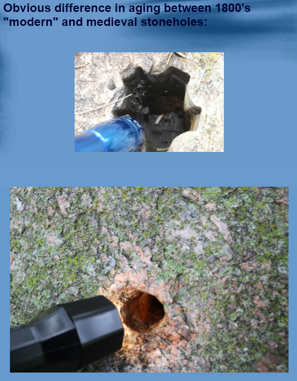
Screenshot showing Voyle's comparison of stone hole weathering.
With respect to shape, Volyes points to differences in the regularity of holes created with modern drilled versus those created by hand chisels.  In a January 2016 article titled "In Defense of the Kensington Runestone: Stoneholes," Voyles makes the following statement:

"The medieval stoneholes are slightly triangular because it is not possible to make a perfectly round stonehole with a hand chisel. Later modern drilling could make perfectly round holes, and this is how old and new can be distinguished from one another."

I think Voyles is correct that are groups of holes made using different techniques. My issue comes with equating "triangular" or "hand-chiseled" with "medieval." A little searching online turned up some descriptions of early American stone quarrying methods that are useful, I think.  The first quote is from the 2005 book The Art of Splitting Stone: Early Rock Quarrying Methods in Pre-industrial New England 1630-1825 (Mary Gage and James Gage) in a section titled "Hammer Drilling or Triangular Hole Method" (page 48):

​     ". . .Triangular holes are documented at archaeological sites in Massachusetts, New Hampshire, Delaware, and Great Britain. Archaeological, historical, and experimental evidence has demonstrated that the triangular holes were cut with a straight edge chisel being rotating approximately 60 degrees between hammer strikes. These holes come in a wide variety of diameters and depths.
     Frederick Pohl in his book The Lost Discovery has documented and researched several triangular hole sites found in stone outcroppings along the tidal waters and bays on Cape Cod . . . Mr. Pohl felt a straight-edged chisel rather than a plug or star drill was used to drill/cut the triangular hole. To verify his theory, he conducted an experiment. He and two other people, "taking turns leisurely cut a hole 1 1/4 inches deep in five minutes. We found we could not make a round hole with a straight-edged chisel. All our attempts resulted in triangular holes with the corners rounded.""


Gage and Gage point to other interesting accounts of using hand chisels to create stone holes. A 1904 book by Halbert Powers Gillette titled Rock Excavation: Methods and Cost is quoted in this report by James Gage:

​"Hammer Drilling. – The common weight of hammer for one-hand drilling is 4 ½ lbs; for two-hand or three-hand drilling 10 lbs. The striking face must be flat or slightly rounding, and smaller than the stock of the hammer. The hole is started on a solid and squared surface, with a short drill, for the longer the drill the less effective the blow. Light blows are struck at first. The bit is turned one-eighth of a revolution after each blow to insure keeping the hole truly circular. But in spite of this precaution most hand-drilled holes are three-cornered, or “rifled.”"

Based on the fact that we've got multiple accounts demonstrating that hand chisels were commonly being used to produce holes in rocks in the northern United States at least into the early 1900's (including in Minnesota), and that such methods typically produced triangular holes . . . on what basis could one claim that some triangular/irregular stone holes were created by the medieval Norse?  What is the positive evidence? How could you separate out the Norse holes from all the others that we know were being created?

As Voyles suggests, weathering could be a way to go. If similar tools were used to create similar holes, there's still at least the theoretical possibility that one could differentiate stone holes created in the 14th century from those created in the 19th or 20th centuries by looking at the weathering of exposed surfaces. As Voyles stated in his comments on my blog about the Sauk Lake Altar Rock, "multiple hand-chiseled holes in this rock can be compared to the mineral or mica decomposition of the late 1800's stoneholes to see that they are extremely aged by comparison." I think there's potentially a significant difficulty here, however, if we depend on macroscopically-observable "weathering" to assign relative age. The descriptions of steel chisels "dancing" around in the holes as they're created suggests to me that the edges of hand-chiseled holes might be battered as they are created (rather than smoothed gradually by mechanical weathering). To my eye, for example, the triangular hole shown by Gage and Gage in Figure 20 (page 49) appears to have a battered/smoothed lip.  Perhaps there would be a way to look at some microscopic characteristics of the stone and say something about aging.  You'd have to have good controls for that, however. If I were trying to build a case that some of these stone holes were created by medieval Norse, I'd start working on that aspect and looking for other ways to differentiate them from modern holes.

That's my two cents on stone holes for today.
96 Comments
Carl Feagans link
9/9/2016 09:31:53 am

What would be the purpose for the holes for Norsemen?

Reply
Gunn
9/9/2016 08:12:37 pm

Hello, just joining the debate. I'll start from the top.

Thanks for the question. There are several purposes for the Norse to carve stoneholes in rocks. In Europe a primary purpose was for mooring ships, on treeless coastlines, for example, but there does not seem to be that reason for carving stoneholes here in Minnesota. In fact, H. Holand was incorrect about stoneholes here being used as mooring stones, and that has caused many innocents to think big Viking ships anchored at Runestone Hill! This is one of the first ideas I've tried to dispel.

The second main purpose for the Norse to make stoneholes would be for securing land boundaries, or in essence, for helping to establish land boundaries. This was done rather extensively in Iceland. Metal rods were used, or wooden poles, so boundaries could be seen at a distance, if possible. I believe most of the stoneholes up in this region are related to marking up land, either for future settlement/ownership, or possibly for claiming land.

Construction is another reason the medieval Norse would have used stoneholes. For example, two stoneholes in the Altar Rock of Sauk Lake are horizontally bored, apparently for placement of an altar shelf.

Of course, there is another reason I believe the Norse made stoneholes, and this is more controversial: for concealing items within a stonehole pattern.

So these are the main reasons for stoneholes, besides also for more modern quarrying work. Context is everything. Are stoneholes found at quarrying sites? Are stoneholes found is obscure, uninhabited regions, in conjunction with other seemingly medieval artifacts, such as the Kensington Runestone, with a dozen or so of these stoneholes basically surrounding the discovery site?

Thank you for your genuine question.

Reply
Thinking Jake
9/9/2016 11:37:05 pm

These stone holes and their uses for "placement of an altar shelf" and "for concealing items within a stonehole pattern", do they have any parallels in Europe or was this only done in Minnesota?

Gunn
9/11/2016 05:07:52 pm

Thinking Jake, that's a good question, and I don't know the answer without research. Both would be good areas to research.

I do know through reliable sources that the medieval Norse enjoyed using codes. Scott Wolter had the idea that sacred geometry may have been used at Runestone Hill to encode or conceal where the buried runestone was. I don't support his idea that the KRS is a land claim; I think it is a very real memorial stone to ten massacred men, as described in the inscription. But, perhaps a geometric design using the dozen or so stoneholes at Runestone Park preexisted the placement of the KRS...as though the knoll was on a ley-line for inland mapping, for instance, and the proposed design laid out upon the ground was to conceal something else. Curiously, a proposed design I found has a large X in it. You may see this pure speculation here:

http://www.hallmarkemporium.com/kensingtonrunestone/id27.html

So, though I know of no circumstances of using stoneholes for concealing anything in Europe, I think we may have some reason to think stoneholes may have been used here in far in-land America to conceal items of historical significance.

As you may know, the proposed medieval Norse Code-stone I found in 2015 seems to indicate that something made of metal is buried deeply in a precise spot on a particular ridge near Appleton, MN...and my ferrous-only metal detector positively indicates the same thing. My regular metal detector will not get a hit, which means the target is deeper than the foot-or-so a regular detector would hit. In essence, I believe that medieval encoding using stoneholes has met her modern-age cousin...the metal detector.

Thanks for the question.

Harold Edwards
9/13/2016 06:36:12 am

I contacted the Archaeological Institute in Iceland.

According to the Director, "these boreholes must be something else than medieval, scandinavian property markers. . . we have never found drill holes in rocks in Iceland from the medieval period. Property markers were often natural features, such as a stream or a hill, in some cases there may have been a cairn erected, but often a boundary was more an idea than an object, such as, a straight line between such and such river and such and such hill."


Reply
Bob Jase
9/13/2016 09:59:07 am

"we have never found drill holes in rocks in Iceland from the medieval period"

Further proof for lost technology!

Gunn
9/13/2016 11:58:50 am

...been busy unloading the 20' U-haul. I'll run down through this blog again to address any more comments or questions.

Okay, Harold, I see you're up to your old tricks again. It's easy to perceive your overall bias...again. Here is something to directly oppose what you just posted. I don't like it when someone attempts to make it look like my word isn't good. There are plenty of people who think folks from Sweden and Norway (think Iceland) made these same stoneholes we've been talking about here, and as you can read, yourself, someone who knows what he was talking about addressed this very issue.

http://www.arkansasstonerepair.com/contact-us/11-history-trivia/15-mystery-stone-holes

"Though the evidence eliminates the idea of mooring ships, it does not quite eliminate the idea of early Nordic explorers. Valdimar Samuelsson, a retired airman in Iceland, offers a separate theory.

“In Iceland we have stones with holes,” Samuelsson wrote in an email to the Public Opinion. “I have found some as boundary stones marking farm boundary. They are called the high stone and low stone.”

Holes in stones would have a variety of uses, Samuelsson wrote. Some were mooring stones, but some marked the beginnings and ends of rivers, or marked roads (especially in the winter). Under Medieval Icelandic law, commoners would mark their land by sticking a marking rod into the holes.

Given the Icelander's drive to explore and their sudden disappearance from Greenland, explorers could have traveled as far as the Midwest area, either through Hudson bay or New York state where several stone holes have been found, he said. They could either have been marking their trail or sectioning land off for themselves.

After looking at the GPS coordinates of several notable holes, Samuelsson said he has found a pattern similar to the manner the ancients would section land.

Naturally, a theory like this demands powerful evidence. The notion that Nordic explorers entered the Midwest would change a significant portion of American history."

Harold Edwards
9/13/2016 12:37:04 pm

When was Mr. Samuelsson born? 1300? 1400? 1950? Was he there in Medieval Iceland? How exactly did he come to learn about these stone holes and their use in Medieval Iceland as property markers? How does he date their age? Why has this great truth eluded the professionals at the Archaeological Institute in Iceland and elsewhere for the last 100 years or so of formal study?

John (the other one)
9/13/2016 03:18:58 pm

Gunn, do you not see the difference between testimony from the story of a retired airman enthusiast and the director of an archaeological institute?

Americanegro
2/5/2017 03:18:24 am

Wouldn't "the beginnings and ends of rivers" already be marked by the beginning or end of the river?

Greg Parsby
9/9/2016 09:43:21 am

If they are Norse and medieval, could you then compare them with holes from Scandinavia from the same period to see, if they share pattern and weathering?

Reply
Andy White
9/9/2016 09:45:31 am

For the purposes of relative weathering, though, you'd have to have similar rocks and similar weather. I wonder if there is any prehistoric Native American rock art in Minnesota that could somehow be used.

Reply
Harold Edwards
9/10/2016 08:54:04 am

For Native American rock art in Minnesota, there are the petroglyphs at Jeffers near pipestone. Incidentally, the pipestone quarries were the source of materials for tobacco pipes traded and used extensively around North America by native peoples.

http://sites.mnhs.org/historic-sites/jeffers-petroglyphs

For information on direct dating methods and the problems therein see the numerous papers by Robert Bednarik:

http://www.ifrao.com/robert-g-bednarik/

Gunn
9/11/2016 05:27:42 pm

Andy, I'm back in CO now. That was a long time on the road!

Anyway, I just thought of something possibly even better than Native American rock art to use for purposes of relative weathering comparisons.

Judi Rudebusch knows personally about the very deeply carved image of a medieval Scandinavian drinking horn to be found along the Whetstone River, and accompanied by stoneholes, if I am not mistaken. There is a picture of this carving in Wolter's X book that you assigned to your Forbidden Archaeology students. Since this carving was most likely carved by visiting Norsemen from the same general time period being proposed for the medieval stoneholes, it seems like that carving would be a good petroglyph to use for comparisons. (Actually, many of the proposed medieval stoneholes could be compared for ageing, such as Judi was involved in with the molding samples, but perhaps expanded out to include other stoneholes, such as those in MN, too.)

Another carving that could be possibly be used for stonehole ageing comparisons is the Copper Harbor Norse ship, which you are now probably familiar with.

Native American rock art was not carved deeply using iron, so that those petroglyph comparisons would probably not be of much value, in my opinion.

Judi Rudebusch
9/12/2016 02:01:26 pm

Mr. Edwards, oddly, there is a rock with a trishaped hole at the Jeffers site. Another side note on Bednarik..I had discussions with him as to lightning effects on boulders with a hole in them-what would a holed stone look like if struck by lightning. He answered to the photos I sent him that a hole with water if hit by the extreme heat and force of lightning would cause the shattering seen on the pictures IF one could prove that they weren't blasted. Good to see you here, Mr. Edwards. I look forward to your info on the KRS...I am struggling with the calcite questions.

Harold Edwards
9/12/2016 02:39:36 pm

Judi, as to calcite, you can ask your questions here or to me directly. I believe you have my contact information. I will try to answer them as best I can.

Andy White
9/12/2016 02:49:58 pm

KRS calcite: I'm hoping to have a post about it in the next couple of days. If you can wait to talk about it then, the conversation will bd of benefit to many people.

The drinking horn rock carving: given that that carving is (like the stone holes) undated, you can't use its weathering to infer the age of the stone holes. What if the drinking horn carving is not Norse?

Judi Rudebusch
9/12/2016 05:29:49 pm

Glad to hear you are going to hit on the calcite, Andy. M. Michlovic sent me his paper where he hit on many subjects concerning the KRS. No, Mr. Edwards, I do not have your contact info-but if possible, Andy could communicate with you on how to reach me, or visa versa. The only so called 'quote' I have concerning the horn rock is from a professor, Brian Molyneaux, who viewed the rock. He was gracious to stop out and view the stoneholes and I showed him the horn rock- he said, that is old. Can we prove the horn is old...or Really old? so far, no. We can find articles that show horns were used in land transactions in the middle ages.. we can show horns used to hold powder in historical times. I sure would like to find a way to age date these things...not to X year, X day... but more in the range of + - 400 years!

Mike Morgan
9/9/2016 10:12:59 am

Short answer, probably not. The rock types would be different and the climate/weather through the years would not be the same between the two areas. This is the same problem many, INCLUDING Bob Voyles, aka Gunn, ( see his comment of 5/31/2016 12:37:18 am @ http://www.jasoncolavito.com/blog/scott-wolter-j-hutton-pulitzer-doesnt-have-any-credibility-on-oak-island-sword-issue#comments ) have with Wolter comparing the KRS to Maine tombstones.

Reply
Greg Parsby
9/9/2016 01:51:04 pm

So comparative weathering is not an option, but one could compare styles between the holes in MN and Scandinavia?
Do we have any images of holes from Scandinavia?

Gunn
9/11/2016 05:57:56 pm

I don't think you have this correct. I think it looks like comparative weathering of carvings and stoneholes in rocks will most likely be valid, using modern techniques not yet completely utilized. More and better science needs to be applied to the study, though.

Stonehole style or type is very crucial. In the future, I aim to clearly show the differences in style between "modern" and medieval stoneholes, using suggested qualitative and quantitative analysis.

Greg, yes, there are known images of stoneholes from Scandinavia from the late Middle Ages that for all intents and purposes are just like copies of some of those found here in America. I think Wolter's book may also have information about this, and I believe Judi Rudebusch has an elderly Scandinavian friend who did a lot of work on this angle years ago, to show an earlier comparative use of stoneholes here in America and in Scandinavia. Maybe she will tell us more about this man's contributions to the study of stoneholes, in more detail.

Another person she knows of did a lot of GPS work in Minnesota to help identify the known locations of some of these proposed medieval Norse stoneholes. I would like to see his work publicly recognized, too, if Judi would like to assist.

Gunn
9/9/2016 08:32:02 pm

Yes, there is the recognized problem of different types of rock and different kinds of climatic conditions and other factors (shading of trees, for example) affecting the comparisons. However, I don't think it is necessary to look for exactitude here. I hope it is not overly naive of me to consider that there is an obvious difference to the naked eye between late 1800's stoneholes and medieval ones. If one looks at the examples shown above, by Andy, one can see that the inside wall of the late 1800's stonehole is not pitted at all, and very undecayed-looking. The one from the Sauk Lake Altar Rock appears very degraded, even to the naked eye. I'm saying that I don't think there is a problem in distinguishing between the two...which is why I gave the examples for comparative study. Of course, exactitude is desired, but we have what we have to go with for now. I think the scientific answer will be that medieval carvings are obviously more aged than modern ones, even to the naked eye.

I think that you could compare the American medieval stoneholes to the European medieval stoneholes and find the approximate same degree of aging...enough to clearly place them all out of a modern context.

Thanks for the question.

Reply
Bob Jase
9/9/2016 02:05:16 pm

Now a 'real' archeologist would take air samples from the holes and use potassium-argon dating but you know, if that was done, the conspiracy would only cover up the 'real' results.

Reply
Gunn
9/9/2016 08:43:05 pm

Well, Bob, I'm not a real archaeologist...nor have I pretended to be. I'm fascinated by medieval Norse history in America's upper Midwest, and I'm an amatuer historian of the same.

Please explain how air samples and potassium-argon dating would apply to stonehole aging or research. I'm willing to look at any scientific approach that would help the discussion.

What conspiracy are you referring to, Bob? I'm not a conspiracy freak, so my good name doesn't apply to conspiracy nonsense at all, if that's what you were insinuating. Is that, like, a "fringe slur."

Thanks for the comment, though I would have preferred a sincere question.

Reply
GEE
9/9/2016 02:56:35 pm

People, whether Norse or not, create holes from Rock climbing, docking boats, ice fishing, or fishing period.. and other reasons.
Guess I'm more interested in how the age factor came into play.

Reply
Gunn
9/9/2016 08:51:43 pm

Hi GEE, yes, people make holes for all kinds of reasons, but we're concentrating on medieval Norse stoneholes here. The age factors are actually quite simple, since we're studying stoneholes from only two distinct periods, the late Middle Ages between about AD 1100-1350, and the pioneering/quarrying period around the late 1800's, early 1900's. I contend that the ageing differences can be noted with the naked eye...though I'm in favor of more scientific approaches.

Reply
Jim
9/9/2016 04:00:42 pm

Food for thought :
Here is a link for Dartmoor Nat. Park, Near Plymouth southern UK. I am no historian but I don't believe the Vikings settled in that part of the UK.

http://www.dartmoorcam.co.uk/cam/previouswalks/2011-4-28_RedLake/redlake.htm

Here is a boundary marker with stoneholes from Dartmoor, quite distinctly different from random stone holes, (scroll aprox. 3/4 the way down the page)

http://www.dartmoorcam.co.uk/cam/previouswalks/2011-12-28_PewTor/pewtor.htm

If you go there and check it out,,, Beware of the The Hound of the Baskervilles . And if you see Sherlock, have him investigate these stoneholes !

The answer way be just as simple as "aliens did it"

http://messagetoeagle.com/mystery7edgestar.php#.V9MxWbEkodU

Reply
Gunn
9/9/2016 09:14:49 pm

Thanks for the many lovely photos to look at, Jim. It was interesting to see the somewhat star-shaped stonehole like the one posted here in this blog, above, which shows it to be from fairly modern quarrying using some type of machinery. I found another exact copy in a lady's garden near a surveying site...the site of the code-stone. In this case, the stonehole was used to put a pole into, supporting a tent. I have an old photo from the late 1800's showing the stonehole rock being used for this purpose...to secure tents against the wind, on ridges.

Jim, as I stated above to someone else, a lot depends on the physical, geographical context of the location where the stonehole is found, and whether quarrying took place nearby, or whether very aged-appearing stoneholes have shown up in places where it was unlikely that anyone would have considered quarrying, or blasting.

I consider Tom Trow's input to be academically invalid, because all he did was quote one person's take on stoneholes and then he extrapolated that out to all stoneholes. Dumb, really, and he ended up suggesting that Scandinavian farmers have inherent DNA-related memory problems...not very nice.

But the proof against Tom Trow and Jason Colavito is that many of these medieval stoneholes have shown up in places where blasting would have been a ridiculous idea, either because plenty of smaller rocks were available, or because the stoneholes appeared in places where farmers have never considered clearly land. H. Holand wrote a lot about this.

Reply
Jim
9/9/2016 10:10:49 pm

Hi Gunn, As per our previous conversation :

"Hi Jim, did you happen to read anywhere that these proposed medieval Norse stoneholes are exactly like known examples in Scandinavian countries, as well as Scotland? This is comparative evidence, is it not? "

This shows there are examples of similar stone holes outside of Scandinavia, I dare say they can be found all over the world. This kind of takes the wind out of your sails with regards to your claim of comparative evidence, does it not ?
As to having smaller rocks in the vicinity as an argument against blasting: What shape were these smaller rocks ? Say one was to build a mortar free foundation which was often the case in the olden days, would you need squarish and angular rocks, or would you use round rocks ? Try building a wall using bowling balls and you might get my drift.
As to the dating of the holes: You stated to Gee

" The age factors are actually quite simple, since we're studying stoneholes from only two distinct periods, the late Middle Ages between about AD 1100-1350, and the pioneering/quarrying period around the late 1800's, early 1900's."

These are your dates, when discussing these holes are we to accept only your dates? I find no compelling evidence to go with the AD 1100-1350 dates.
Much of your evidence in regards to the dates and the Norse involvement revolves around the KRS. Most consider this to be a hoax. Without proving the KRS to be authentic the dates and Norse aspect can be thrown out the window.
Also I have to ask what code is this you speak of, is there anything compelling other than a hunch ?

Judi Rudebusch
9/9/2016 05:17:30 pm

Stoneholes is a name we penned, because it was obvious that all the holed boulders we see today can not claim the name "mooringstones". As far as Scandinavia is concerned, many look to the drawing where ring pins are inserted into bedrock extrusions in a Bergen harbor- this dated in the 1500's. Many do not realize that there were two early ways to secure this ring in the rock hole-- sulfur, the later lead. Up in Sloops Cove-Churchill Canada- Parks Canada has great picture of holed and cut off ring pins in rock in Sloops Cove- that are high and dry due to isostatic rebound in that area...are they Viking- no, much later. One has to be very careful, since the holes to date, can not be dated-say they know what is or is not old as far as the holes in the rock. We must remember one important point- these holed stones were not called 'mooringstones' and medieval age, until Hjalmar Holand needed 'add on sales' to promote the KRS. Holand himself in his books, relates that he knew the stoneholes were 'old' because of the shiny inside surface--worn shiny...ok, today, we have others who promote them as being old because of their weathered, rough in side walls---sorry, you can't have it both ways.

Reply
Andy White
9/9/2016 06:52:23 pm

Hi Judi,

I was hoping you'd chime in. I haven't yet gone through the stuff you've sent me, but it's on my list. What's your current thinking on the "blasting holes" explanation?

Reply
Judi Rudebusch
9/9/2016 07:15:58 pm

Blasting:Dynamite Stick size*middle to late 1800's*, according to the Rapid City School of Mines, measured 1.5 to 2 inches in diameter...so far, I haven't found one hole that large-so, to use that large diameter of stick of dynamite would be like putting too small a dress of too large a lady...that said....much cheaper to use was black powder. Burned slower causing less expansion. It could literally break a rock and leave, in some cases, some of the hole. What Tom Trow was quoting from, was his tape made of Emil Mattson, neighbor to the East of the KRS hillsite, neighbor to the Ohmans. On the farm where Emil lived, there is a boulder with a hole in it. Also there, are a few rock that can be seen in the barn foundation walls that exhibit the 'bevel'. A bevel *term I use* is the part you see when a stone is shaped and a hole is chiseled into the rock to split, leaving a bevel- like opening a sandwich- you have a half-a-hole. Yes, the Gages have a good book *actually two that I know of that James sent to me* and worth reading as to rock work on the East coast. I had a man who does quarry blasting come and look at some holed stones to get his opinion. In quarry blasting, common practice is to make the hole at least half the depth of the block of stone to split it-- with modern blasting techniques. He was puzzled by the depth of the holes I showed him. He said that IF dynamite was used, there hardly would be room for the powder, packing and fuse to be all in that size of hole to do any damage-especially when the boulder is so surrounded by land.. but, if black powder was used, it would and could just take off the top presenting part of the boulder- early farmers who didn't do the deep plowing, could just skim right on over the rock if it had just blown the top part off. Am I saying all of these holed stone are modern? I had wished weathering ratio analysis could help.. as we have some known dated holes to work with.

Gunn
9/9/2016 09:35:24 pm

Hi Judi, I'm happy to see you commenting here. Holand is kind of a hero to me because of the intensity of his search, but he did really goof on his ideas that these stoneholes were for mooring ships here, which led to the improper signage at Runestone Park, giving visitors young and old alike the wrong impression of these stoneholes. He believed so strongly in King Magnus's Paul Knutsen search party hypothesis that he ended up attributing nearly all the stoneholes and metal objects he found out about to that one unproven search party.

Rather, I think it looks like many medieval Norse expeditions came this way...at least several besides the KRS party. It looks like they were EXTREMELY interested in the land where you live, too! Both the KRS and the Sauk Lake Altar Rock suggest Christians visited here, not pagans like Big Ole the Viking, a stone's throw from the Runestone Museum.

Thanks a lot for all the work you did on this subject. It really helped me get started, and it made me realize just how intense the attempted land-uptaking appeared to be along the Whetstone River. We're still looking for answers about that, right? You were right all along, year ago: "These stoneholes have stories to tell." Indeed, they do.

Reply
Robert Wooten
9/9/2016 06:36:43 pm

Ancient American Magazine mentions over and over articles about copper mineing in Michigan by Lake Superior. They believe the Minoans and or the Myceneans, using indian labor are doing this work to create the Bronze age in the mediteranian. Maybe you should look that way while searching for the cause of the holes.

Reply
Andy White
9/9/2016 06:53:34 pm

What would copper mining in the UP have to do with holes in rocks in Minnesota?

Reply
Gunn
9/9/2016 09:50:35 pm

Robert, there aren't any indications that I know of to suppose that the medieval Norse stoneholes are related in any way to cultures going back much farther than the late Middle Ages. I saw a few years ago that people were trying to attribute the Copper Harbor sailing boat petroglyph to these ancient peoples, and I decided to do some research. I found out that the petroglyph is actually depicting snake-heads at each end, which were characteristic of medieval Norse ships back in the day. Here is where you can see a photo of the Lake Superior petroglyph, which is medieval Norse in every respect, helping to show us a medieval Norse past in this region:

Gunn
9/9/2016 09:51:33 pm

Whoops...here:

http://www.hallmarkemporium.com/kensingtonrunestone/id21.html

Gunn
9/9/2016 10:15:46 pm

Thanks, Andy, for the soapbox. I think this is your main question, and I will try to answer it succinctly, as I'm quite tired from loading a 20-foot U-haul all day. (I'm bound for Colorado this weekend.)

"How do you know the holes were made by the Norse?"

Andy, the main reason I "know" is because of the presence of these aged-appearing artifacts in relationship to other artifacts supposed by many to be both medieval and Norse, such as the KRS itself. And, as Judi well knows, these stoneholes appear along the entire length of the Whetstone River just across the Minnesota border, in South Dakota. She also knows that various petroglyphs accompany some of these stoneholes in her immediate region. They appear to mark waterways, as well as land, in some cases.

These stoneholes in America suggest a pattern of use, which seems to have involved marking waterways, and probable land-uptaking attempts.

Andy, this is what I propose the Norse Code-stone is all about...and its location is a mere half-hour drive from the heavily marked-up Whetstone River.

I know in my heart and mind some of what happened here, but it's a real challenge to help others believe, too. Occasionally, they do.

Thanks again for giving me a chance here to answer sincere questions about medieval Norse stoneholes...and may the skeptics shudder....

Reply
Andy White
9/10/2016 04:40:35 am

Hi Gunn,

Thanks for taking the time to go through the comments. I've spent way more time than I'd like over the last few years loading and unloading UHauls, so I get where you're coming from.

I'll still be stuck on the "how do you know which ones are Norse" question before I'll be willing to move much farther. There are several possible components that one could explore to help make the argument that some of the stone holes pre-date (and are unrelated to) Euroamerican blasting activities.

First, I think you have to throw out the "irregular or triangular shape" argument. You can use that to identify hand-chiseled holes, but in this case "hand-chiseled" does not equate to "medieval" (we know that the same hole-making techniques were being used into the 1900's).

So one avenue that's left is the weathering. You say "ageing differences can be noted with the naked eye...though I'm in favor of more scientific approaches." I'm sure that there are apparent differences in the degree of weathering of these stone holes, but how am I (as someone who isn't looking at them myself) to evaluate your contention that you can group them into "younger" and "older" groups? Without data, I can't. If age differences are apparent to the naked eye, you should be able to find some way to capture those differences qualitatively or quantitatively. What weathering attributes could you measure or characterize on each stone hole? This would not be a trivial undertaking, but it would provide a way for others to evaluate the criteria you're using to characterize stone holes as "old" or "modern." If weathering can be used to reliably discriminate "old" and "modern" holes, objective data on weathering should show the presence of two distinct groups (and those two groups may also be different in other ways - depth, for example).

In other words, I think your argument about the Norse age of the some of the stone holes has to start with the intrinsic characteristics of the holes themselves. That's the source of your data and needs to be the foundation of your argument. If you start interpreting the holes before you can show, reliably, why some are old and some are not, it makes your interpretations much less compelling.

And I also think you have to be careful of circularity: "the holes are Norse because they're along this river, and we know this river was explored by the Norse because of all these stone holes."

That's my two cents for now (I guess I'm in for at least four cents now). If you could produce a database with the characteristics of individual stone holes (depth, cross-section shape, diameter, some characteristics related to weathering) it would be fun to play with. Then one could include other known-age or known-purpose examples from other places in the world and see how they compare.

Reply
Judi Rudebusch
9/10/2016 05:00:13 am

on weathering characteristics: a man has molded many many of the stoneholes, C. Courneya. He came out and molded a few of the ones in my area. One thing I have been noting: do they hold water. From the molds, one can see if there is shelving in the rock, thus letting water seep away from the hole. Concussion of the pounding of the hole might be reason for this. Anyway, one notes on the molds- that a hole that keeps it water for an extended time shows more weathering-sides and bottom. Holes where there is shelving lines-where water seeps away from the hole- shows weathering roughness only after the last shelving line. SO many data points here to say that weathering to the eye is a determining factor. I starting using an endoscope that can be hooked right to ones' laptop -can be taken right in the field and close ups/stills show the inside weathering. In the area, most of these holed stones are in glacial granite erratics. Granite has a colossal mixture of minerals, with quartz being the hardest, micas might be the most easy to degenerate the fastest.

Judi Rudebusch
9/10/2016 07:23:54 am

Andy, as to your thoughts on taking the diameters, depths- those are all done, at least for the ones I have in my data base--but what does that really tell us? So far, all I can see is that a common chisel was used to make them appear triangular or tri archal in shape... a star drill *5 points rotated makes a round hole*. The chisel has been around for a very long time.

Jim
9/10/2016 10:59:02 am

Hi Judy, I was wondering if you could give us some idea as to the depth of these holes ? Thanks.
As far as blasting or splitting , goes the deeper the better. ( there are other methods of splitting rock using drill holes besides blasting)
When using the holes to mark territories, leave a message or mark a route I can't for the life of me see why one would drill more than an inch or so. What would the point be with such a laborious task to drill more than an inch ?

Andy White
9/10/2016 11:22:51 am

Yeah, that's kind of what I had in mind with looking at the distribution of depths. Is there a single modal depth with some variation around a mean, or do the holes group into "shallow" and "deep"? I would be interested to see what the distribution of depths looks like.

Judi Rudebusch
9/10/2016 04:36:00 pm

Depth of holes stones: yes, they vary. I saw one about 12 inches..that is the longest for what I have seen. Most are 4-7 inches deep. There is one stone, two men could move it, with the smallest diameter hole- just over 1/2 inch in diameter. I have tons of pictures, maybe at some point they can be put up here. Why would one blast a stone with a hole that small? beats me. Granite, if using one hole to split in a straight line- won't do it. Because minerals are not all lined up like in limestone, minerals in granite go this way and that...you know, like when a rock hits your windshield- it ends up going this way and that across your windshield..that is how a granite rock would split unless one would put a number of holes in row. There is a video of man who put a number of pounding chisels in a row across a huge boulder, he just kept tapping them till finally it cracked right off in a straight line. Ok-how else did they blast stone at the turn of the century around my area? so far, the oldsters have told me 3 ways other than putting a hole in a stone: 1- putting sticks of dynamite dug around the button the boulder 2- mud packing was very common and effective 3- freezing..I have heard that they would put a hole in a hole in boulder, let it freeze and the rock would crack by spring....my experiment doing this didn't turn out too well. We made a hole in rock, 4 inches deep, in a low area on top of a stone. I carried water to that hole all winter (-20 degrees F many times)..the water always evaporated *yes in the winter*.. so how? I found out how long the rock kept it's heat, far into winter! My Dad split rock by putting old tires on them and setting the tires on fire.

Jim
9/10/2016 05:53:59 pm

Judi, Many thanks, I get a much clearer picture of the holes with this.A lot of interesting info there. Weird about your freezing test, baffling. Of course with your mentioning of the 1/2 inch diameter hole I now wonder about the variance in the diameters of these holes ! Do you think we are talking a number of different sized chisels here ?

Seamus
9/10/2016 07:10:28 am

If these medieval Norsemen were here long enough to drill all of these holes, where is the other evidence of their presence? Where are the camps and settlements and the detritus they would leave behind?

Reply
Jim
9/10/2016 07:42:25 am

Here is an informative 1984 publication "Hand Drilling and Breaking Rock" By the US dept of Agriculture.

https://www.fhwa.dot.gov/environment/recreational_trails/publications/fs_publications/pdf/pdf84232602.pdf

Reply
Jim
9/10/2016 09:36:11 am

Regarding triangular and squarish drill holes :
Seems to me the method of hand drilling with a chisel usually involves a strike followed by a slight twist (1/8 turn) and strike again, rinse and repeat. This should give you roundish hole rather than an angular one. I recall this from a long ago tour of a Welsh slate mine, and am reminded of it with the Hand Drilling and Breaking Rock guide.
Would not a non rounded hole be indicative of an inexperienced or amateur driller ? If so could not Gunns stone holes be catalogued looking for signatures and similarities of individuals ? If a grouping of holes in one area were attributed to a single persons signature and a group of holes a good distance were similar to each other but different from the first group, would this not lend support to the individual farmer breaking up rock theory ? If medieval norse were responsible for these holes would it not seem reasonable that a single person or select few were tasked with this ? Especially in light of the whole code thing etc. ? I can't see a whole lot of these fellows carting around hammers and chisels through hundreds if not thousands of miles of rigorous travels where every pound is a detriment.
I could see this as very telling.

Reply
Judi Rudebusch
9/10/2016 04:41:28 pm

I don't know if it is an oddity or not, but I have watched how when using a flat chisel in rock, it naturally goes into a triangular shaped hole- or tri arcle.. To be truthful, from what I have seen, it would take a much more experienced man to make a hole more round- just my take, though. Rapid City School of Mines, in SD, have a competitions where guys use the 'old' method of making holes with what they call the single and double jack method..with the single jack method, one man holds the chisel and rotates it as the other man hits it...it turns out triangular! *would you like to hold that chisel? :)

Reply
Jim
9/10/2016 05:09:42 pm

Judi, Thanks, I may have to do some more armchair research on the round vs triangular holes. As far as holding the chisel, in my younger years I held many a railroad spike while someone slammed down a spike mall on it to seat the spike. My advice, don't hold it for the new guy !!!

RiverM
9/10/2016 02:06:17 pm

Is the stone hole data, dimensions and such, mentioned in earlier posts available to the public? The verdict is still out on the KRS and even recently became much younger in the eyes of it's greatest supporter, did it not? Without proof of it being medieval Norse it appears weathering or detailed hole dimensions comparative to known medieval holes across the Atlantic are needed to prove age, but not necessarily creator. Very interesting, thank you Gunn, Andy and those who provided their input.

Reply
Susan
9/10/2016 05:12:09 pm

Great discussion with great information and ideas. Thanks both to Gunn and Andy. I have two questions for Andy: What is the thinking on the petroglyphs associated with these stone holes? Secondly, and this may be a silly idea, have you considered having any of your students "recreate" any stone holes by trying to hand drill a few of their own?

Reply
Andy White
9/12/2016 02:56:45 pm

I don't know much about the petroglyphs of the region, unfortunately.

We won't be doing any experiments of that magnitude in this class, but who knows, maybe someday. I think Pull did some chiseling experiments and found it didn't take long to produce a hole, but they naturally became triangular because making a round hole with a straight-line tool is more-or-less impossible.

Reply
Jim
9/11/2016 05:01:47 pm

Are those bloody meddling French (perhaps from Nova Scotia) responsible for this whole fiasco ?

With regards to the stone holes being survey markers or boundary stones. It seems to make some sort of sense if you use the Seigneurial system of New France rather than the English township system.

https://en.wikipedia.org/wiki/Seigneurial_system_of_New_France

Apparently this system is still noticeable today in Detroit. It might explain numerous boundary markers on elevations at a distance from the river banks of Minnesota.
Minnesota was part of New France, "Upper Country (Canada)" up until the Treaty of Utrecht in 1763.

https://en.wikipedia.org/wiki/File:New-France1750.png

https://en.wikipedia.org/wiki/New_France

While I have seen no evidence of stone holes in regards to this, the Seigneurial system seems to dovetail nicely into where these rocks (land claim markers ?) were found in relation to waterways and rivers.

Reply
Judi Rudebusch
9/11/2016 06:11:59 pm

something that might interest you, google Ruperts Land- and note where those boundaries are.

Reply
Jim
9/11/2016 07:07:50 pm

I'm Canadian eh ! So I am somewhat aware of Ruperts land and the Hudson bay company. Actually what triggered the Seigneurial system of New France was grade school memories of the Riel Rebellion and the land claim aspect of it. The long narrow plots emanating from the Red river.
Any thoughts on the Seigneurial system with regards to the stone holes in question ?
Also I read" New thinking on the "Mooring stone" Theory ", good stuff there! Got any more ?

Jim
9/11/2016 07:22:35 pm

Note,, the Treaty of Utrecht was 1713 not 1763

Reply
John (the other one)
9/11/2016 07:41:57 pm

Judi - thanks for your information on this point I find more background about this topic informative. I'm interested in knowing if there is a US map superimposed with clusters of "stone holes" I have been informed they are plentiful and near water. It seems the simplest reason is for stone cutting and then putting the stone on a boat.

After the historical boundary info was just shared I'm now more interested in knowing if you have info about where they generally occur.

Judi Rudebusch
9/12/2016 04:51:59 am

Jim: that story was put on the internet, changed as to what I wrote. I learned a lesson as to who one gives information to. The man who put this up on the net had his own agenda, sadly that escalated to his death. There is an article in NEARA Journal with some info as of 2007. More information has been found in the last years, but nothing written at the moment.

Jim
9/12/2016 11:09:47 am

Judi, Yikes, that really sucks!

Gunn
9/12/2016 12:56:16 am

Jim, since you brought this up, I would like to stress that the proposed Norse Code-stone I found is showing in miniature a special arrangement of stonehole rocks on a ridge overlooking where the Pomme de Terre River discharges into the beginnings of the Minnesota River (actually, Marsh Lake), near Appleton. The Pomme de Terre reaches farthest north into the Minnesota River watershed...which might mean something if a party were intent on claiming a significant portion of land.

Of special note is the fact that a late 1800's railroad surveying crew camped and made large, modern, sometimes fancy stoneholes in this exact same spot, in order to place thick poles into the solid rocks for pitched tent support against a stiff wind.

So, I'm saying that there exists for examination two distinct groups of stonehole rocks at the same location on the ridge, for which I have proposed two vastly and distinctly different time periods, whereupon two groups of men made numerous stoneholes for the same purpose of marking significant waterways. I believe the Norse went a bit further and buried something, hopefully something that will one day give us good indication of who the medieval surveyors/land-uptakers might have been.

Waterways were the Scandinavians' highways and they used them to get around, and I believe to help mark certain areas, and in some cases to claim land for the future. I believe this long-distance prospecting for land likely originated from Iceland, where land before disease hit was deemed scarce and they weren't afraid to go out exploring, looking for more land...for which Vinland is a great example.

I happen to believe that these Scandinavians also came down from Hudson Bay, too, completing the huge inland waterway circle from different oceanic sources that was completed near where many of these proposed Norse activities took place. It was all about waterways--and then fresh spring water, too, eventually, in some of these specific locations.

Thanks again for the input.

Reply
Jim
9/12/2016 02:58:08 am

Thanks for the response Gunn. I have no knowledge of the Pomme de Terre River site, seems odd though, two different parties separated by almost 600 yrs choose the exact same spot to drill multiple stone holes.
As to waterways, in early North America everyone used them extensively. The entire fur trade was based upon them. We borrowed the canoe from the native population and used them heavily.
When you look at the French Seigneurial system for land surveys it was based on waterways. This is in your bailiwick so you might know this already as a good portion of the lands with stone holes seem to be in what was once New France. Long story short, the rivers were everyone's highways.
Not saying it can't be used, but Hudson Bay is a pretty tough go for for small sailing ships and only useful for expeditions of a year or more. Winters were longer back then, so there was probably a window of less than 4 months to get in and out on a trip unless you are staying the winter. It's a 1300 mile trip getting in or out of the bay so subtract that time from your less than 4 months window when it wasn't frozen over. Henry Hudson was cast adrift and perished in his bay after telling his crew they were to continue exploring the bay. This after spending the long winter there with the ship locked in the ice.
All in all, it seems like a lot of Norse spent a lot of time in North America without leaving much behind other than holes in rocks. (L'Anse aux Meadows notwithstanding)

Gunn
9/13/2016 12:43:37 pm

Jim, I think it would help if you thought of Native Americans assisting the Norse in their travels. I believe Wolter is correct about the notion that travel far inland would have been nearly impossible without the approval and aid of particular American Indians.

To the East of this Kensington Runestone (MN) and Whetstone River (SD) region, generally, the Chippewa ruled; to the West, generally, the Souix ruled. If we pause to take notice, the KRS massacre occurred in an area (up the Chippewa River) where this entire area was under constant embattlement...some of it similar to the Hatfields and McCoys.

It appears to me that the KRS party was mostly likely escorted to the Chippewa River area, but a Sioux war party came across the Norse campers who thought they were in a safe enough area. Obviously, they weren't.

By the way, when I talked to the property owner of the west bank of Davidson Lake, recently identified by myself as the probable lake with two skerries a day's travel from Runestone Hill, he mentioned that the lake is shallow and has mostly pike in it.. Though I think the lake was likely a foot or two deeper back in 1362, it probably didn't offer good fishing. If the men were anywhere near close to beginning their return trip to their awaiting ship/s, ten of the men were AWAY from Davidson Lake (and imminent danger), and probably fishing for walleye to wind and sun dry...great protein on the road...er, waterway, and no need to fish or hunt on the way back. This, of course, is pure speculation.

Though I think plenty of Norsemen of Old came down from Hudson Bay, we can be sure because of the KRS inscription that the KRS party came West from Vinland, a well-known place at the time.

It really interests me that a Catholic priest visited Vinland so early in recorded history, well before the 1362 KRS. The so-called Chikio Stone found just west of Morris, MN, currently sleeping in the KRS Museum, may fit in well with H. Holand's view of the Sauk Lake Altar Rock (mis-named the Viking Altar Rock).

Jim
9/13/2016 02:39:14 pm

Gunn, sorry but a have to disagree with you on most of these points.

First of all, your whole scenario with the American Indians is pure fanciful speculation that fits your theory. There is no point debating something like that. And again a lot of this hinges on the KRS being authentic, it is generally considered a hoax.

As far as far as your speculation on the fishing trip: Walleye are much harder to catch than the voracious pike, also they are mostly nocturnal feeders, coming up out of the deep to the shallows at night to feed and returning to the deep in the morning. Better tasting than pike, sure, but you are much more likely to get skunked fishing for them. Pike on the other hand will bite any lure and almost jump in your boat of their own free will. If they wanted to catch lots of fish, stay on Davidson Lake and fill your boat.

Now, going west from Vinland to the Hudson Bay pretty much puts Vinland in the Arctic. Not many grapes growing there !
Perhaps the St Laurence Seaway might be a better "west" route from Vinland. This of course is again going by the KRS which,,,, well you know.

"It really interests me that a Catholic priest visited Vinland so early in recorded history" ,,,,,,I know naught of this could you enlighten me?

Mark L
9/12/2016 12:35:04 am

Much as I admire Andy for trying this, are you not already aware it's a waste of time? You're all being very polite, but within a day he's resorted to "well, I believe they're real" and references to the KRS. And Gunn at least seems polite and relatively willing to discuss his ideas. The chances of you getting an article to post to your blog from him, that fulfils even the most basic scientific standard, is close to nil.

Reply
Gunn
9/12/2016 01:06:17 am

Mark L, do I detect a built-in bias? It is very brash of you to state that this discussion about stoneholes is a waste of time. Aliens is a waste of time. Of course there would be references to the KRS in any good discussion about medieval Norse stoneholes.

I'm sure this very worthwhile debate about stoneholes will continue, making good progress along the way. You sure are negative. Are you related to Joe Scales and his many aliases in any way?

You come across as someone prematurely disappointed in the future. Why not just give peace a chance here? You added nothing here, except an example of how to troll a decent blog.

Reply
Andy White
9/12/2016 02:57:39 pm

Joe Scales is not participating in this discussion. Let's leave him out of it.

Gunn
9/12/2016 01:56:09 am

Okay Andy, I stayed up late tonight and put together a new page on my website showing two distinct groups of stoneholes representing two vastly different ages, as you would like. These two groups can be distinguished from one another by each group supporting their own distinctive types, as I have shown photographically:

http://www.hallmarkemporium.com/kensingtonrunestone/id44.html

I'm talking about intrinsic characteristics that cannot be ignored by the scientific community. Please look at the photos I just published, many for the first time being seen by the public. I started out with one of the large, fancy stoneholes deemed "modern," and included a distance shot and then a closeup. You will see that I basically alternated the late 1800's stoneholes with distance shots and closeups of the five distinctively different proposed medieval Norse stonehole rocks which make up the encoding on the ridgeline near Appleton, Minnesota.

Please take special note that none of the late 1800's stonehole rocks has more than one stonehole in it, and that all the stoneholes are very large--in fact, extremely large compared to any of the proposed medieval stoneholes. Now, also please see that the proposed Norse stonehole rocks each have more than one stonehole in it...each have two stoneholes on a relatively small rock, except for the Norse Code-stone itself. But, notice also, that one of the rocks on the ridgeline did have three holes in it and it appears that a chunk of rock was cracked off from this third stonehole. I'm not sure because I didn't want to disturb the soil at all around the small chunk of rock, but I believe this chunk of rock was placed where the encoding and metal detector both say something made of metal is deeply buried.

As for your interest in stonehole depth, one very curious feature about the code-stone is that the holes start out shallow and end up deeper and deeper. As bizarre as this may sound, I think this is a clue to suggest going down, or to dig. I'm supposing there must have been a reason for the encoder to do this, and it fits in with the theme of the medieval circus on the ridge.

Anyway, I hope readers will now be able to readily see that there is evidence to support my contention that both "old" and "new" stoneholes coexist at the same location, and both were for the purpose of waterway surveying of one kind or another.

Lastly, I hope some perceptive and unbiased readers will now see that there is likely sufficient good reason to think that a beginning scientific case might be able to be made for the reality of authentic medieval Norse stoneholes.

By the way, just a reminder that a small-diameter stonehole like those on the ridge exists near a spring-fed pond in proximity of other more typical medieval stoneholes, near Wilmot, SD.

Andy, you are most welcome to post these new comparative grouping of stoneholes on a new blog in the future, if you'd like to carry on a further discussion of stoneholes. I've been in stonehole heaven these last few days, and I hope I may have stumbled into a bit of science for folks along the way.

Don't hesitate to let me know if there's any approaches you can think of that might help me fulfill my goal of having a professional dig conducted at the ridge location near Appleton, and thanks again for your efforts in setting up and conducting this recent blog heading on what I consider to be a very important area of "Forbidden Archaeology."

Reply
Pablo
9/12/2016 05:42:21 am

To me, making holes in rocks in order to build something speaks of permanence. When I go camping, I don't pour a slab because I most likely be there for only one night and it wouldn't be worth it. So If a group of people decides to go through the work of making holes on rocks with what should be very precious tools in the middle of a place where they can't easily replace them, far from home, etc. that to me means that those people were doing that because that is a place to stay. If that was considered a permanent place, then, the amount of evidence around the area would be consistent with the work it takes to create those holes for whatever purpose they wanted them. My opinion.

Reply
Judi Rudebusch
9/12/2016 06:02:43 am

I did some looking into the Seigneurial system. Yes interesting but a point might be missed here-there were other systems of land dividing-not always in precise squared areas. In ESOP Journal, 2007, Valdimar Samuelsson puts out an interesting theory as to how land was divided in Iceland very early on. As with the Seigneurial system, it begins with the sustenance of life- water, then it many times goes in a more pie shaped direction towards higher land. Each part, is what the land man needed- water, soil for tilling, soils for haying, pasture land higher up for the summering of livestock.

Reply
Jim
9/12/2016 10:15:59 am

Certainly all evidence should be considered, the French being there however is a proven fact. The Norse, not so much. If you scroll down this link you will see an extensive list of French forts built on what is now US soil.

https://en.wikipedia.org/wiki/List_of_French_forts_in_North_America

It seems the scope of of Gunns proposed Norse undertaking is much larger than than I initially thought. He speaks of pretty much exploring the entire eastern half of North America. From the Hudson Bay to the St Laurence Seaway and I'm not sure but probably the Gulf of Mexico.
In Gunns answer to Gee earlier in this convo. he gave the timeline of 1100 to 1350. This is a much more massive undertaking than I had initially thought and still not a lick of provable evidence.
L'Anse aux Meadows on the other hand had a relatively small number of people over what is believed to be a short period of time and left a very discernible and provable footprint.
It is also interesting to note that the Sagas of Icelanders which helped to find L'Anse aux Meadows was written 2-3 hundred years after the fact during the approximate time of Gunns Proposed ventures. And yet not a written word to be found of this much more massive undertaking.
Call me unconvinced !

Reply
Gunn
9/13/2016 01:44:58 pm

Thank you for the comment Pablo. Sorry it's taking me a while to respond. I'm unloading the U-haul in "sets" to get a workout of sorts without exhausting myself, and making some occasional responses along the way of unloading, this time.

Permanence, yes. Where would you like to put your imprint to claim land? How would you do it? You make a very good point, Pablo. In this case, the land in this proposed area was most likely deemed extremely valuable because it represents the waterway meeting place of two beginning oceanic sources...down from Hudson Ban, and west from Vinland, through the Great Lakes, including, finally, Lake Superior.

And how would one claim land in this region? Yes, as we're now learning on this blog, by putting their now-more-obvious intention in stone. It's almost like writing something in stone. In the case of the Whetstone River stoneholes, I personally think they in many cases went also with particular Norse petroglyphs, in order to claim parcels of land, usually accompanied by springs. I look at it simply, like branding cattle. In this case, though, the petroglyph becomes the hot iron, as the cattle join a like-branded group...the stoneholes in the same identifiable vicinity.

The visiting, exploring, land-claiming Norsemen needed a region heavily populated with welcoming rocks in order to make permanent their intentions. Very perceptive, Pablo. Thanks for the comment, as it was helpful in exploring the possible past scene I've just painted....

Gunn
9/13/2016 02:25:36 pm

Thank you, Jim, for the several provocative comments and questions. I'll try to work through your above comment systematically. First, yes, I propose multiple expeditions into this region we're examining here, pretty much exploring the area boundaries you just mentioned...and yes, to be sure, possibly including the Gulf of Mexico, since one may go up as far as the first falls back then, St. Anthony's Falls by Minneapolis/St. Paul, Minnesota. Please take note on a map that the Minnesota River enters the Mississippi River just south of this natural impediment. So, by veering west and following the Minnesota River, any brave party of medieval Norsemen would have ended up going the same route to the area we're focusing in on. So, we do actually have no less than three proven possibilities for ending up far inland in America at the same exact location: precisely where we are talking about, where these dwindling waterways merge, completing a huge waterway circle. I hope you see that this is why this specific area is heavily marked-up with Norse-appearing evidences.

Jim, I put the timeline loosely from around AD 1100 to AD 1350 because the early part of this time period represents the end of the Viking Age and the beginning of Christianity being spread outward in Scandinavia...it happens also to coincide with the founding of the Templars, who were the muscle attached at the hip for the Catholic Church, as you probably know.

We have evidence of Christianity in both the KRS and the Sauk Lake Altar Rock, if one would care to explore others' renditions of the visual evidence--such as H. Holand's exhaustive view. He wrote an entire chapter on this particular, rare, multiple stonehole rock. Here's something of special note: Sauk Lake and the Sauk River empty into the Mississippi River north of the abovementioned falls, which seems to indicate Norse exploring up past the falls.

We should also make note here, because of an element of your comment, above, that another Norse site has only recently been discovered within the greater mouth of the St. Lawrence Seaway, considered one route into the Great Lakes region. Google "Point Rosee, Newfoundland."

Jim, you are incorrect about not a written word to be found of "this much more massive undertaking." I've done my reading on Iceland, Greenland, Norway, Vinland, etc., and I can assure you that there is a mountain of material written about this very subject of Norse penetration into the North Atlantic region. I've also done extensive reading of the available Sagas, and you are doing a disservice to them for suggesting that they are of little value. I don't wish to be rude, but I think your take on history is a bit skewed. But, nevertheless, thanks for opportunity to explore these things further. Perhaps one day I will be able to convince you of the existence of authentic medieval Norse stoneholes deep within America, which I claim are the very glue holding all this genuine medieval Norse history together up here.

Bottom Line: No one has adequately explained away these still-mysterious stoneholes. I say the reason is because they can't be explained away. Science and academia should be able to explain them away if they're not authentic, but so far they haven't been able to.

Excuse me for saying so, but both Tom Trow and Jason Cavalito, in my opinion, made fools of themselves for publicly espousing the notion about inherent Scandinavian forgetfulness in relation to "unblasted" stoneholes. That was and still is pretty lame, but then again, I guess both of these men would prefer to see stoneholes as something to fear and explain away.

But not Andy. Yeah for Andy!

Jim
9/13/2016 03:40:26 pm

Just a couple of quick points

The "Sauk Lake Altar Rock" is a rock with 2 holes drilled in it, how in the heck is this evidence of Christianity ?

Where did I suggest the Sagas are of little value ?

Point Rosee, I know of it. Words like potential, possible etc. are used. I will wait until the research is done to form my conclusions. Look what happened with the KRS !

John (the other one)
9/13/2016 03:48:47 pm

One of the issues you have going on is that you wish to see Norse exploration and write stories to explain it. Another issue is your lack of professionalism, and I understand it, you aren't a professional. If you wish to be taken seriously you should act more seriously. Don't accuse people of being other people and don't insult people for no reason.

It is appropriate to say "I disagree with Jason colavito and tom Trow".

It is inappropriate to say "they made fools of themselves" just because you disagree with them.

There has yet to be one piece of evidence presented here that says anything Norse. Your biggest defense so far is Scott Wolter, KRS, some other random rocks that are probably hoaxes, and fanciful storieS.

Harold Edwards, whose opinion I respect after what he has posted on the KRS said a scientist in Iceland supports the idea that there are no Icelandic Medieval stone holes.

The KRS is a hoax and Scott Wolter is a human hoax, what else do you have besides holes in the ground and fanciful stories?

Gunn
9/13/2016 04:09:15 pm

Well Jim, I sure can't stop you from being a skeptic-at-heart...but there's nothing to debunk about medieval Norse stonehole. They exist and can't be explained away by academia...or yourself.

Okay, I tried my best so far with you, patiently. Hopefully, one day in the fairly near future, we will all learn more about the many exciting medieval Norse expedition into this region. Frankly, I consider myself to be on the cusp of history truth, not at any silly fringe.

Finally then, facts, science and truth will determine who was on the fringe all along--those risky skeptics and would-be debunkers. In the end, I suppose they will all look kind of foolish for trying to prove something to be false that was true all along.

I will end now, hoping some might remember the Christian lives lost a day's journey north of Runestone Hill, on a fateful day back in 1362. I think they camped too long in a rough neighborhood--but at least their horrific deaths were memorialized in stone.

Gunn
9/13/2016 04:19:07 pm

John (the other one), or Joe, your last repugnant comment doesn't deserve an answer. All I can say is that some people seem bent on being disagreeable, no matter how hard one tries to be patient and somewhat professional. I certainly don't need someone as publicly repugnant as you are to explain blog professionalism to me. Seriously, doesn't the word "troll" mean anything to you? As far as I knew, this blog was to advance a worthwhile discussion, not to blatantly attack someone trying to advance new ideas. You show no respect for Andy's openness.

Jim
9/13/2016 04:32:30 pm

Gunn, I for one would be tickled pink if all this were to be proven true. I just don't see the evidence.
Skepticism and science are best friends.
Good luck with your research, and if you prove this to be true, I will be the first one to line up at the crow buffet !

Andy White
9/13/2016 04:33:53 pm

Announcement: I'm all for vigorous debate, but the arguments have to be about ideas and evidence. If we can't have a serious conversation I'll close the comments.

Do I think there's a possibility that there was a medieval Norse expedition into the American interior? Sure, it's possible. Am I convinced it occurred based on any of the evidence I've seen so far? No, I'm not.

The whole point of having a discussion like this is to try to understand and evaluate the basis of a claim. I'm hoping we can do that (for once) without personal attacks. If we can't this idea is dead in the water.

Reply
Gunn
9/13/2016 06:16:05 pm

See what a purposeful troublemaker can do, Andy? That's fine with me, but I hope you recognize that some come here for the sole purpose of attacking the presenter, not to move anything along. If you noticed, some can do it in a mean-spirited way, instead of using tact. I will usually react when I notice that someone is more intent on attacking me than my message. But until that last rude comment, this was a great blog and I truly enjoyed myself.

Oh, I wanted to mention that the Wikipedia introduction to the Kensington Runestone is wholly inadequate and completely biased, and someone regularly trolls the KRS entry and engages in all too obvious bias and slashing of anything that he doesn't agree with. I can provide you with more information about this if you would like to delve into it.

I like your new idea for a "lightening post" from time to time. I think I'm finished with my input on stoneholes for now. It was great until the souring at the end here. Thanks again, and I'll plan to be in touch if anything new and substantial comes to light. If you want to talk more about stoneholes a bit later this fall, perhaps I can help in the discussion in some way. I'm kind of burned-out for now. Later.

Reply
Harold Edwards
9/13/2016 06:30:20 pm

I for one would hate to see you go. I would like to see you keep participating. I think we differ in our views. I will probably not change your mind, nor you mine. The point is for the others to see what you have to offer and evaluate it on its merits. Hang in there.

Reply
Tom Rent
9/14/2016 07:04:46 am

I have GPS mapped all 170 (or so) of the Midwest “triangular” stonehole boulders that Judi has information on. I also have hundreds of photos of these stonehole boulders including many "down the hole" with an endoscope. Conclusion, they don’t support the medieval Norse occupation hypothesis.

When these boulders are plotted on a map, the majority of these boulders are within reasonable distances to waterways, but this is because early settlers first settled near moving fresh water and were hand-drilling holes in these glacial erratics to allow splitting, blasting, and dislodging for use in foundation construction or for land clearing. Yes, some stoneholes look more weathered than others, but then you can find “fresher ones” sometimes on the same property. The variance in “look” is due to susceptibility of weathering of the specific rock type and the hole’s ability to hold rainwater, accelerating weathering.

Another reason many stonehole boulders are found near waterways is because that is where most people searched for them back when the mooringstone idea was being promoted by Holland to bolster KRS authenticity (and his book sales). It is even likely some stonehole boulders in our database were drilled along Minnesota waterways in the 1900s leading to Kensington to support Holland’s story. I see no evidence that any stoneholes were drilled to mark waterways or for marking borders, and most are so obscure that one can’t imagine they would be used to mark anything. The vast majority are in large granite erratics embedded in soil that would be hard to dig-out by hand or with crowbars, or so large that they needed to be broken apart to move.

If marking waterways by holes in stones was a Norse practice, then we’ve see these holes all the way back to Scandinavia. We don’t.
Some people use the stoneholes as “proof” the KRS is authentic from the 14th Century, and these same people use the KRS to “prove” the stoneholes are medieval Norse. This begs the question – If the KRS was never found in 1898, would these same people claim the stoneholes were medieval Norse? The answer is no. Archeology and anthropology rely on a reasonable set of “normal” evidence of occupation or visitation to establish truth – graves, garbage, campsites, clothing, tools, etc. None of this exists to support medieval Norse in the Midwest.

One final point; recently researcher Paul Stewart determined the numbers on the KRS (8, 22, 2, 10, 10, 14) align with the number sequence for the Select Master Degree ritual of the Cryptic Rite Masons, a ritual not established until the 1800s. This same number combination was also found in the 1885 Beale Papers, a document now associated to the Cryptic Rite Masons. It is a near certainty that the KRS was carved in the late 1800s, leaving little reason to believe the stoneholes were drilled by medieval Norse.

Reply
Jim
9/14/2016 11:49:44 am

Yes, thats my take as well. The whole Medieval Norse theory hinges on the KRS. Its all long on theory and speculation, but rather short on facts.

Reply
Americanegro
2/5/2017 03:52:55 am

I know that when my friends get slaughtered, the first thing I do is find a large rock, carve an elliptical story about it, then bury the rock. It's just common sense.

john (the other one)
9/15/2016 07:54:53 pm

Tom - could you share an image of that, like superimposed on a map? I'm interested in seeing what they look like as I've had difficulty finding a data set to plot myself. Like are they on both sides of the same junction of two rivers, things like that.

Also, for anyone concerned that my name is Joe as I was apparently accused of above, rest assured my name is actually John.

Reply
Jim
3/3/2019 08:38:26 am

Here is Gunn's metallurgy test on his iron object that he claims to be a medieval chisel holder he discovered at Runestone Hill.

https://www.facebook.com/photo.php?fbid=116490662824838&set=p.116490662824838&type=3&theater

9.37% Aluminum.

He had this tested years ago.

https://en.wikipedia.org/wiki/Aluminium#History

"Attempts to produce aluminium metal date back to 1760.[54] The first successful attempt, however, was completed in 1824 by Danish physicist and chemist Hans Christian Ørsted. ,,,,,,,,,,,,,,,,,, In 1856, Deville along with companions established the world's first industrial production of aluminium."

In other words, there was no aluminum in the metal form until at least around the 1850's.

Reply
Harold Edwards
3/3/2019 10:06:53 am

This amount of aluminum is not out of line with Medieval Scandinavian iron objects. See Iron and Steel in Ancient Times By Vagn Fabritius Buchwald, p. 306 for a table giving compositions of iron objects found in Scandinavia. One nail has 19.6% Al2O3 which converts to about 10% Aluminum.

Reply
Jim
3/3/2019 11:34:17 am

Thanks Harold, surprising, but I learn something new every day.

Jim
3/3/2019 11:49:59 am

Harold, is there anything else that you noticed on Gunn's metallurgy test that would disqualify the object as a Medieval artifact ?

Harold Edwards
3/3/2019 01:54:06 pm

The analysis he gives is not a pure metal. For metals oxygen should be close to zero. Given the high iron content it is probably a metal object with considerable contamination from rust and clay materials--soil. More to the point. Runestone Hill where I believe he claimed to have found the object has had considerable digging. In April-May of 1899, Ohman's neighbors came out and dug up the site. Since then it has been farmed by Olof Ohman and his son Arthur Ohman. Also there have been at least two archaeological digs at the site in the 1964 and 1975-6. Since the 1960's it has been a park owned by Douglas County with a groomed landscape. It is doubtful that all of these people missed an iron object of any kind. Finally I think the burden of proof is on him to demonstrate it is a Norse object. Let me remind you that the Scandinavian immigrants who flooded into the area in the 19th Century brought with them antique heirlooms from Scandinavia including objects with runic inscriptions. Some of these are on record.

Harold Edwards
3/3/2019 04:04:07 pm

You don't want to waste a lot of time on this. There is a good chance he just made the whole thing up. The sample is something he fished out of a dumpster so he could brag to the Latter Day Vikings down at the Runestone Bar about it.

Jim
3/3/2019 07:45:14 pm

Thanks Harold, I think it's a worn out tooth from a backhoe or loader bucket, but who knows. The aluminum content struck me as odd, given the history of aluminum, I thought it may prove a modern date.

Jim
3/3/2019 09:01:12 pm

Just to be clear here Harold, are you sure the aluminum oxide ( AL2O3 ) would read as Al on the graph in Guns report and be termed Aluminum even though it may have been non metallic ?

In Iron and Steel in Ancient Times By Vagn Fabritius Buchwald he refers to it as AL2O3 not Al, so would not that refer to a non metallic Aluminium oxide material such as a ruby ( AL2O3: Cr ). An Oxide mineral rather than a metal ? And would not the test used differentiate between the 2 ? ( Al2O3 and AL, a mineral rather than a metal )

Harold Edwards
3/3/2019 09:34:11 pm

What we have is a case of apples and oranges. Gunn's analysis is in elements. We then have to infer what the phases are: metals, minerals or whatnot. Actually, to have a proper analysis we should have more information. Identifying substances by chemistry alone is insufficient and leads to errors. In Buchwald's case he has reduced his chemical analysis to oxides, a common way of presenting analysis. Again we do not know what the phases that are in the samples actually are. This way of presentation, though common, is a "legal fiction" so to speak. Metals contain little or no oxygen so some corrections have to be made if the samples are in fact metals. Again we should have more information. With proper techniques there will be additional information along with the chemistry so we can assign elements to the phases from the chemical analysis. There you have it.

Jim
3/4/2019 07:55:52 am

O.K., thanks again.
What a dumb metallurgy test, that can't differentiate between a gum wrapper and a gemstone.

Harold Edwards
3/4/2019 11:37:16 am

Some notes on process:

First using a metal detector to find buried artifacts on Douglas County parkland is against the law. Runestone Hill comes under the authority of the Minnesota State Archaeologist and thus requires a license from him or her to conduct such work. Archaeologists are not merely interested in potential Viking or Norse objects at a site but also Native American artifacts, Fur Trade artifacts, Early Historical white settlement artifacts, etc. Hastily digging into the site without taking meticulous notes, photos, and measurements does a disservice to everyone. The integrity of the site was violated.

Second, metallurgy is a branch of engineering which leads to a Bachelor of Science degree from a major university. If the person is going to specialize in archaeological metallurgy then she or he has to get additional training. For the rest of us to understand the issues involved, i.e., Norse steel technology, requires considerable background reading. I call that "doing your homework."

Here are some resources:

1. A Google Scholar search:
https://scholar.google.com/scholar?hl=en&as_sdt=0%2C24&q=viking+iron+chemistry+metallurgy&btnG=

It yields a number of papers that are of interest and can be downloaded for free, starting with the first. Flip through 3 or 4 pages in the Google search for more. Note that the carbon in steels--the charcoal used to make them--can be dated using Carbon-14 methods.

2. http://www.viking.ucla.edu/publications/articles/warmlander_zori_byock_scott_hrisbru_metals_2010.pdf

This has detailed analysis Viking age iron objects found in Iceland.

3. https://www.academia.edu/34485002/Iron_in_Archaeology_Early_European_Blacksmiths_Pleiner_2006_

You will need to sign up to Academia.

More than you could possibly want.


Leave a Reply.


    All views expressed in my blog posts are my own. The views of those that comment are their own. That's how it works.

    I reserve the right to take down comments that I deem to be defamatory or harassing. 

    Andy White

    Follow me on Twitter: @Andrew_A_White

    Email me: andy.white.zpm@gmail.com

    Enter your email address:

    Delivered by FeedBurner


    Picture

    Sick of the woo?  Want to help keep honest and open dialogue about pseudo-archaeology on the internet? Please consider contributing to Woo War Two.
    Picture

    Follow updates on posts related to giants on the Modern Mythology of Giants page on Facebook.

    Archives

    January 2023
    January 2022
    November 2021
    September 2021
    August 2021
    March 2021
    June 2020
    April 2020
    March 2020
    January 2020
    December 2019
    November 2019
    October 2019
    September 2019
    May 2019
    April 2019
    January 2019
    December 2018
    November 2018
    October 2018
    September 2018
    August 2018
    July 2018
    June 2018
    May 2018
    April 2018
    March 2018
    February 2018
    January 2018
    December 2017
    November 2017
    October 2017
    September 2017
    August 2017
    July 2017
    June 2017
    May 2017
    April 2017
    March 2017
    February 2017
    January 2017
    December 2016
    November 2016
    October 2016
    September 2016
    August 2016
    July 2016
    June 2016
    May 2016
    April 2016
    March 2016
    February 2016
    January 2016
    December 2015
    November 2015
    October 2015
    September 2015
    August 2015
    July 2015
    June 2015
    May 2015
    April 2015
    March 2015
    February 2015
    January 2015
    December 2014
    November 2014
    September 2014
    August 2014
    June 2014
    May 2014
    April 2014
    March 2014

    Categories

    All
    3D Models
    AAA
    Adena
    Afrocentrism
    Agent Based Modeling
    Agent-based Modeling
    Aircraft
    Alabama
    Aliens
    Ancient Artifact Preservation Society
    Androgynous Fish Gods
    ANTH 227
    ANTH 291
    ANTH 322
    Anthropology History
    Anunnaki
    Appalachia
    Archaeology
    Ardipithecus
    Art
    Atlantis
    Australia
    Australopithecines
    Aviation History
    Bigfoot
    Birds
    Boas
    Book Of Mormon
    Broad River Archaeological Field School
    Bronze Age
    Caribou
    Carolina Bays
    Ceramics
    China
    Clovis
    Complexity
    Copper Culture
    Cotton Mather
    COVID-19
    Creationism
    Croatia
    Crow
    Demography
    Denisovans
    Diffusionism
    DINAA
    Dinosaurs
    Dirt Dance Floor
    Double Rows Of Teeth
    Dragonflies
    Early Archaic
    Early Woodland
    Earthworks
    Eastern Woodlands
    Eastern Woodlands Household Archaeology Data Project
    Education
    Egypt
    Europe
    Evolution
    Ewhadp
    Fake Hercules Swords
    Fetal Head Molding
    Field School
    Film
    Florida
    Forbidden Archaeology
    Forbidden History
    Four Field Anthropology
    Four-field Anthropology
    France
    Genetics
    Genus Homo
    Geology
    Geometry
    Geophysics
    Georgia
    Giants
    Giants Of Olden Times
    Gigantism
    Gigantopithecus
    Graham Hancock
    Grand Valley State
    Great Lakes
    Hollow Earth
    Homo Erectus
    Hunter Gatherers
    Hunter-gatherers
    Illinois
    India
    Indiana
    Indonesia
    Iowa
    Iraq
    Israel
    Jim Vieira
    Jobs
    Kensington Rune Stone
    Kentucky
    Kirk Project
    Late Archaic
    Lemuria
    Lithic Raw Materials
    Lithics
    Lizard Man
    Lomekwi
    Lost Continents
    Mack
    Mammoths
    Mastodons
    Maya
    Megafauna
    Megaliths
    Mesolithic
    Michigan
    Middle Archaic
    Middle Pleistocene
    Middle Woodland
    Midwest
    Minnesota
    Mississippi
    Mississippian
    Missouri
    Modeling
    Morphometric
    Mound Builder Myth
    Mu
    Music
    Nazis
    Neandertals
    Near East
    Nephilim
    Nevada
    New Mexico
    Newspapers
    New York
    North Carolina
    Oahspe
    Oak Island
    Obstetrics
    Ohio
    Ohio Valley
    Oldowan
    Olmec
    Open Data
    Paleoindian
    Paleolithic
    Pilumgate
    Pleistocene
    Pliocene
    Pre Clovis
    Pre-Clovis
    Prehistoric Families
    Pseudo Science
    Pseudo-science
    Radiocarbon
    Reality Check
    Rome
    Russia
    SAA
    Sardinia
    SCIAA
    Science
    Scientific Racism
    Sculpture
    SEAC
    Search For The Lost Giants
    Sexual Dimorphism
    Sitchin
    Social Complexity
    Social Networks
    Solutrean Hypothesis
    South Africa
    South America
    South Carolina
    Southeast
    Stone Holes
    Subsistence
    Swordgate
    Teaching
    Technology
    Teeth
    Television
    Tennessee
    Texas
    Topper
    Travel
    Travel Diaries
    Vaccines
    Washington
    Whatzit
    White Supremacists
    Wisconsin
    Woo War Two
    World War I
    World War II
    Writing
    Younger Dryas

    RSS Feed

    Picture
Proudly powered by Weebly