Last weekend I wrote this post about a planned excavation by Heartland Mormons to search for the temple of Zarahemla in Iowa. That excavation was justified by a map produced via a ground-penetrating radar survey. Today, thanks to a comment on a recent blog post by Jason Colavito's blog post, I learned of another example of ground-penetrating radar data being used to propel the excavation of what is almost certainly a fantasy, this time in association with Oak Island.
First, an update on the Zarahemla excavation.
The webpage for the project proclaimed that a professional ground-penetrating radar (GPR) survey had identified the location of a rectangular wooden "temple structure" with walls extending 5-22' below the ground surface. I pointed out that that level of specificity was impossible using GPR and questioned (among other things) how those outlines were determined and how they could possible serve as the basis for an actual archaeological excavation. Coincidentally or not, that webpage (dated January 2015) is not currently available, and the entire Book of Mormon Evidence site is currently "under maintenance."

BookofMormonEvidence.org on 11/13/2016.
I couldn't find any details about the excavation, but I suspect it has already taken place. Blog reader and friend of archaeological reality Mike Morgan located a report of the record of purchase, showing that the 13.8 acre "temple of Zarahemla" parcel was sold to Zarahemla Holdings, LLC, on January 20, 2015. Another of my online friends told me that he recalls seeing images posted on Facebook showing an excavation in progress some time ago, but those images were later removed. That an excavation was planned for the spring of 2015 is also supported by comments on message boards like this one, posted the day before the sale of the parcel closed.
A comparison of aerial photographs of the parcel from June 2014 (before the sale; image from Google Earth) and summer of 2015 (image from the Iowa Geographic Map Server) suggests that excavations were, indeed, undertaken in the area identified as the "temple" in the first half of 2015. The light-colored areas marked with arrows appear to show the areas of backdirt piles and newly-filled excavation areas. Those areas correspond to the location of the eastern wall of the "temple" (unfortunately, since the webpage is gone, I can't reproduce their aerial with the "temple" superimposed [Update: you can see the figure on this website]).
A comparison of aerial photographs of the parcel from June 2014 (before the sale; image from Google Earth) and summer of 2015 (image from the Iowa Geographic Map Server) suggests that excavations were, indeed, undertaken in the area identified as the "temple" in the first half of 2015. The light-colored areas marked with arrows appear to show the areas of backdirt piles and newly-filled excavation areas. Those areas correspond to the location of the eastern wall of the "temple" (unfortunately, since the webpage is gone, I can't reproduce their aerial with the "temple" superimposed [Update: you can see the figure on this website]).
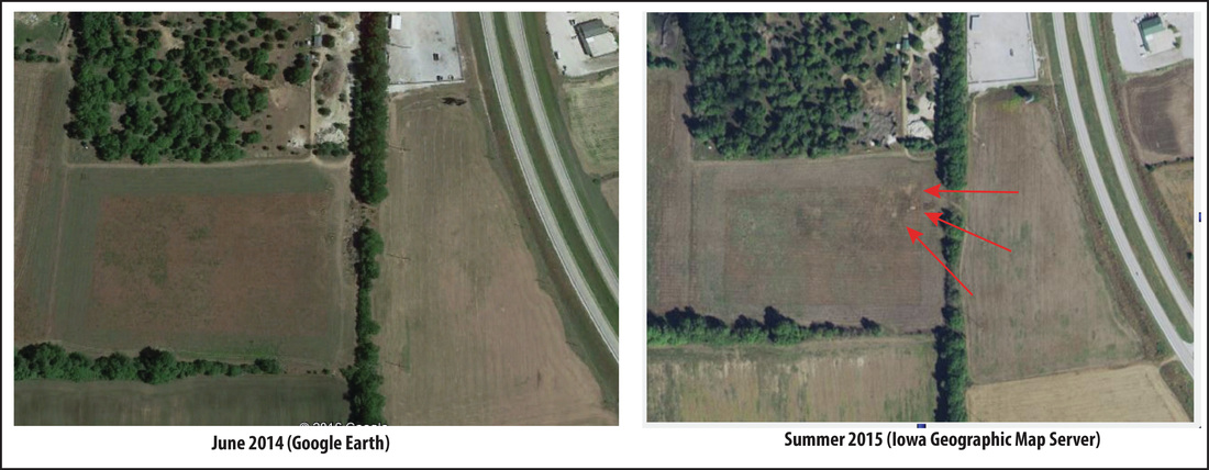
Comparison of aerial photographs of "temple" area from prior to and after the sale.
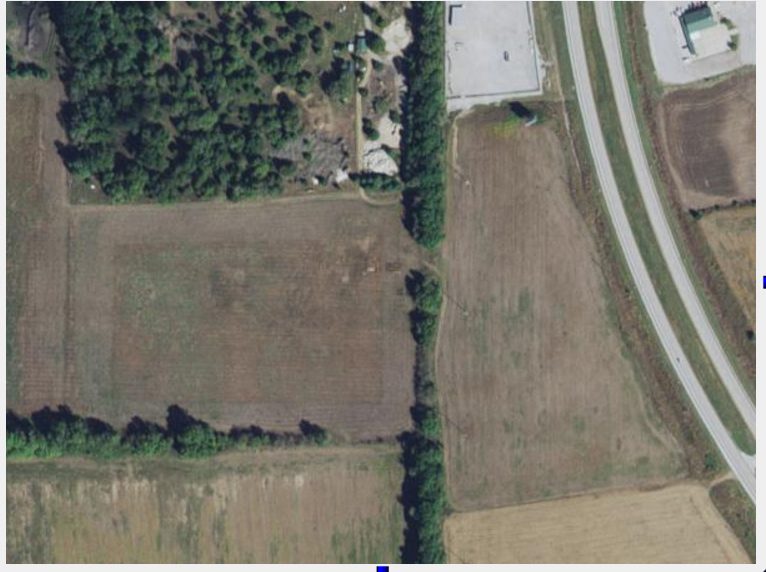
Detail of the "temple' area from summer of 2015 showing the light-colored areas that look like two (?) backfilled trenches.
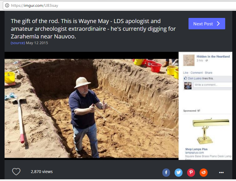
[Update: I found this image from June 2015 that reportedly shows Wayne May, apparently dowsing, in an excavation at the "temple" site.]
A machine excavation into the "temple" area would have quickly revealed that there was no buried, 15-foot-tall wooden wall. Without seeing the raw GPR data and details of how it was processed, there's really no telling what kinds of anomalies, if any, the survey actually detected. But I presume that if the Temple of Zarahemla had been found we would have heard something about it by now. So my money is on nothing. I just hope that no real cultural deposits have been damaged so far in this pursuit.
And now for the new example.
This webpage, dated the 28th of October, 2016, makes a bold proclamation:
"OAK ISLAND RELATED UNDERGROUND FACILITY FOUND ON MAINLAND LUNENBURG COUNTY, NOVA SCOTIA!"
Here we go again.
You can read all the Shakespeare stuff and then get down to the brass tacks of the "proof" that (1) there's an underground facility and (2) it's related the mystery of Oak Island. That "proof," apparently comes down to GPR data. Here's what the site says:
"In March 2015, I conducted GPR scanning around the X marked boulder and have had the files analyzed by very skilled GPR analysis experts. Disturbances in subsurface features can be seen in the data. The experts say such disturbed structures should not be present in normal ground conditions.
In the summer of 2016, a professional GPR firm conducted a second, more extensive scan of the site. The result and report from this scan is still pending. The analysis is complicated due to a number of factors that has to do with GPR settings for best possible data collection. I also have instructions from the Nova Scotia Communities, Culture and Heritage to keep results confidential until a decision has been taken on how the province will react on a report showing interesting results. The 2016 scan was financed by Paul Lappin and Knut Skofteland. I’m very grateful for their contribution to this project."
So, somehow, from these incomplete GPR results, the authors have "proved" that there's an "intact underground facility" or "vault' that contains important things. Let's get the backhoe!
Anyone who understands GPR is shaking his or her head. As I said in the previous post, GPR data are complicated. The equipment works by pulsing radar waves into the ground and detecting the reflections that occur when the waves encounter a material with different electromagnetic properties. Depth can be estimated based on analyzing the two-way travel times of the reflected waves. That's it. Anomalies in GPR data can be caused by any contrast in the electromagnetic properties of the materials that the waves are passing through: open spaces (such as rooms or caves) can cause anomalies, as can buried rocks, changes in sediment, the water table, and numerous other things. Often in a natural setting (i.e., when you're not looking for something really obvious like buried storage tanks) you can't really tell what's "anomalous" until you get data from a large enough area to understand something about what you're looking at.
So . . . yeah, like the Zarahemla example, I'll go on record with the position that what you think the GPR is telling you is not what it's actually telling you.
I think these two examples are part of a trend of the fringe embracing new technologies that they think will provide "out-of-the-box" credibility to their ideas and conclusions. In some cases, the abilities of these technologies are probably being intentionally misrepresented to wishful thinkers. In others, it's apparent that the people using these gee whiz technologies don't really understand them. The screen on a GPR doesn't beep at you and say "alert! buried vault!" The XRF meter doesn't have a "detect Roman brass" setting. And tiny flashlights don't have "old" and "not old" icons to discriminate ancient from modern stone inscriptions. You might as well be using dowsing rods and flipping coins.
Try learning something about the tools you're using and then collecting and presenting data in a way that they can be evaluated. Then maybe someone would take you seriously.


 RSS Feed