Andy White Anthropology
  • Home
  • Research Interests
    • Complexity Science
    • Prehistoric Social Networks
    • Eastern Woodlands Prehistory
    • Ancient Giants
  • Blog
  • Work in Progress
    • The Kirk Project >
      • Kirk 3D Models list
      • Kirk 3D Models embedded
      • Kirk 2D images >
        • Indiana
        • Kentucky
        • Michigan
        • Ontario
      • Kirk Project Datasets
    • Computational Modeling >
      • FN3D_V3
    • Radiocarbon Compilation
    • Fake Hercules Swords
    • Wild Carolina >
      • Plants >
        • Mosses
        • Ferns
        • Conifers
        • Flowering Plants >
          • Grasses
          • Trees
          • Other Flowering Plants
      • Animals >
        • Birds
        • Mammals
        • Crustaceans
        • Insects
        • Arachnids
        • Millipedes and Centipedes
        • Reptiles and Amphibians
      • Fungi
  • Annotated Publications
    • Journal Articles
    • Technical Reports
    • Doctoral Dissertation
  • Bibliography
  • Data

Calcite Weathering and the Age of the Kensington Rune Stone Inscription (Lightning Post)

9/13/2016

227 Comments

 
As my Forbidden Archaeology course descends into the meaty part of the syllabus, the interesting "fringe" topics I'd like to write about are piling up to the point where I'm feeling buried. There was already a backlog, but now I'm finding myself listening to presentations and interviews (rather than music) on my walks to and from work. When I get to my lab, however, I've got people to manage and a hundred other things to do to move my actual research forward -- I just haven't been able to make the time to hole up and spend a few hours composing a thoughtful blog post. One of the reasons I like to write is that the process of writing helps me organize my thoughts. So it's a bummer that I'm finding less time to write during the semester when I'm most immersed in "fringe" claims.

Rather than let things remain unwritten, I'm going to try a "lightning round" approach where I quickly summarize an idea: short and (hopefully) to the point. These posts won't be works of art, but will (1) provide a place for discussion for those who are interested in a topic and (2) provide an organized summary that I can return to. So don't beat me up if I leave something out or fail to appreciate some nuance: it is what it is.

Now onto the topic.

Harold Edwards, a professional geologist and scheduled Forbidden Archaeology participant, sent me some information on the weathering of calcite as it relates to evaluating the age of the inscription on the Kensington Rune Stone (KRS).  Edwards told me that I could "use these pictures and this information as you wish." I'll quote Edwards directly when so you'll know which words are his and which are mine.

First, some definitions: 


Calcite is a common carbonate mineral that is one of the principal constituents of limestone and marble. It has a Mohs hardness of 3 and dissolves in acid.

Greywacke is a variety of sandstone. Sandstone has a Mohs hardness of 6.5 to 7. The susceptibility of sandstones to acid depends upon the minerals holding the sand grains together.

The different hardness and weathering properties of calcite and greywacke are important to evaluating the age of the inscription on the KRS.  I have modified an image of the KRS (taken in 1995 and sent to me by Edwards) to show the location of the calcite deposit on the front face of the KRS.  According to Richard Nielson and Scott Wolter (The Kensington Rune Stone: Compelling New Evidence, 2006, p. 17), the calcite layer is 1-2 mm thick and was deposited millions of years ago "along the joint fracture system [while the rock was still attached to its parent] in solution, parallel to the face side of the stone." (In his email, Edwards stated that the calcite layer was about 3 mm thick).
Picture
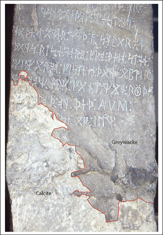
A 1995 image of the Kensington Rune Stone, modified to show the distribution of calcite on the front face (original image from Harold Edwards).
The inscription on the KRS extends into the calcite deposit.  Given that calcite is more susceptible to weathering than greywacke, one would expect that the portion of the inscription in the calcite would be more weathered than the portion in the greywacke.   Neilsen and Wolter (2006: 17) say this is, in fact, the case:

"Microscopic examination using reflected light revealed that the characters carved into the calcite were less distinct and appeared to be more weathered than the characters carved into the graywacke. . . . Further study of the weathering of the characters within the calcite area might yield additional information about the relative age of the inscription, but currently the only tests available are invasive and would deface the inscription."

​In his email, Edwards claims that the portion of the inscription in the calcite is much less weathered than one would expect had the carved runes actually been exposed to 500 years of weathering:

"The inscription is about as sharp as the day it was carved.  Look at the word spacer--the colon-like double dotted letter.  There is an almost perfect impression of a conical punch. The surface of the calcite layer shows the granular texture that is typical of weathered calcite so it was weathered for some time.  The letters are smooth showing virtually no weathering."
Picture
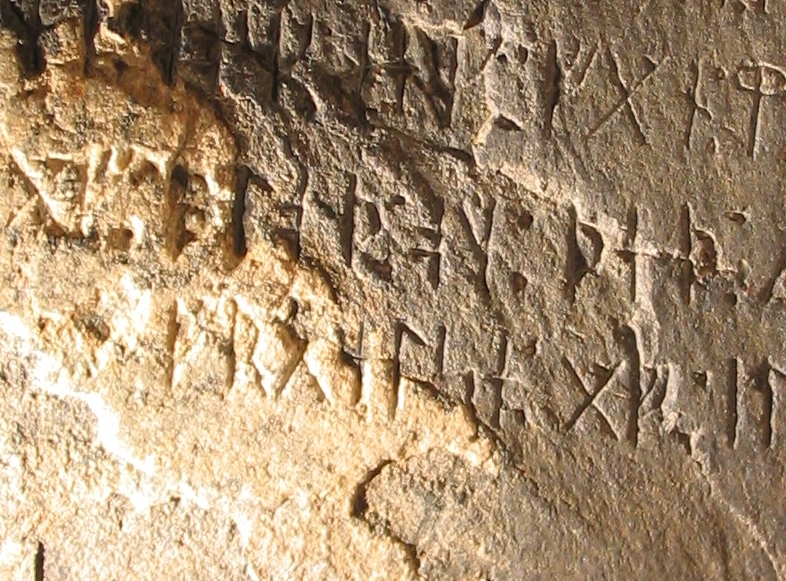
Image of the KRS in 2003 showing the inscription in the calcite area (image from Harold Edwards)
Edwards also sent me some images of marble tombstone from 1881 to illustrate the effects of above-ground weathering on calcium carbonate rocks. Edwards wrote the following:

"Marble is almost completely made of calcite.  Rainwater absorbs carbon dioxide from the air to become slightly acidic and over time dissolves away the calcite.  In the Kensington area this happens to marble tombstones at a rate of 6mm/1000 years.  In other words in the 500 years between 1362 and 1898 the calcite layer would have been obliterated."
Picture
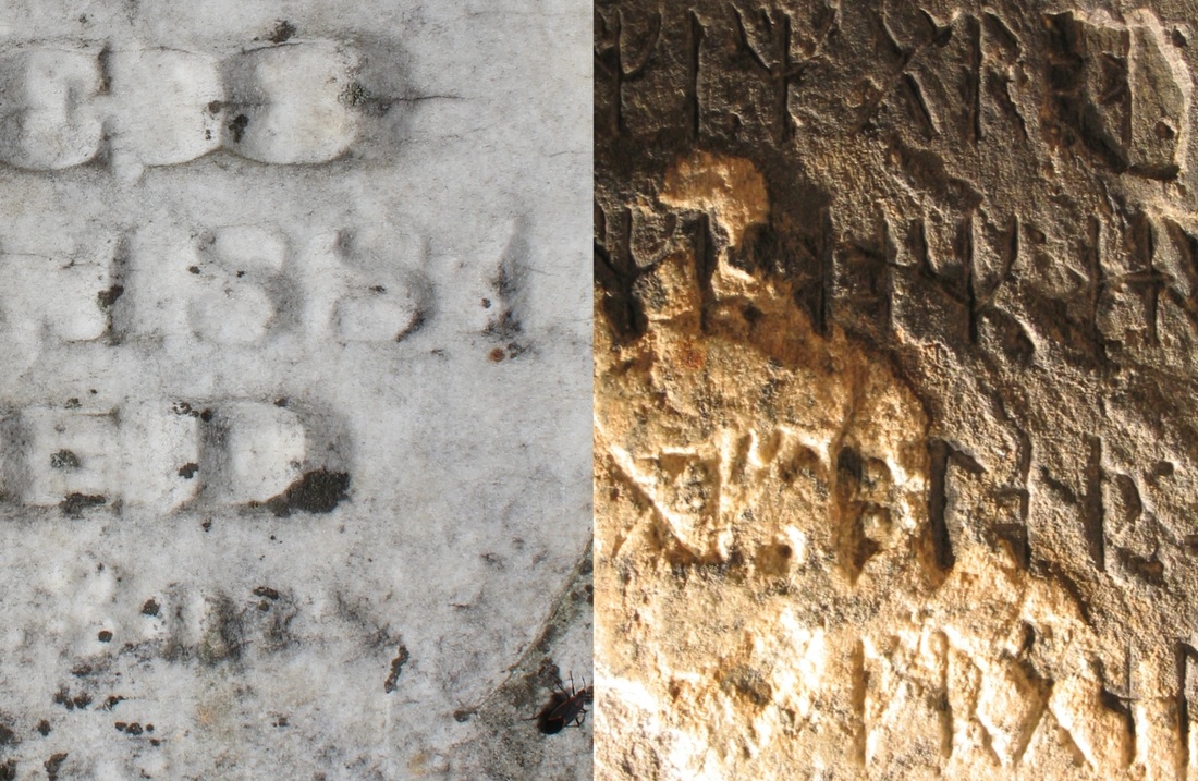
Comparison of a tombstone inscription from 1881 with the inscription on the KRS (image from Harold Edwards).
Anyone who has visited an old cemetery understands that inscriptions in limestone and marble have not faired well over the last 150 years. I had always heard that airbone pollutants associated with the Industrial Revolution increased the acidity of the rain, hastening the deterioration of marble and limestone. Obviously, the KRS would not have been exposed to the same rains as the 1881 tombstone. Even if the KRS was "protected" underground, since it was carved, however, it would not have been immune to the effects of weathering. Edwards has sent me a lot of information on the below-ground weathering of calcite, but I haven't had time to digest it yet. That will have to wait for another lightning post. Or for Edwards to explain it to us here . . .
227 Comments
William M Smith
9/13/2016 08:21:50 am

Andy - Good report, I have some research related to the KRS which may be of interest as it seems to address natural wear and exposure to the stone surface. In the 2003 photo the calcite seems to be weathered more at the upper area than at the lower area. The break area seems to correspond to the mechanical wear line which may indicate the upper portion of calcite was exposed to the air longer than the lower area. My measurements of 60 tomb stones in a like environment of the KRS indicated an estimate age for the KRS in a standing position after carving was about 300 years.

Reply
Andy White
9/13/2016 09:00:50 am

Thanks for the comment. Are you referring to weathering on the inscribed portion of the calcite, or weathering on the calcite surface in general? If the KRS is genuine and was erected above ground, I presume the entire inscription would have been above ground?

Reply
William M Smith
9/13/2016 11:42:17 am

Andy - I am referring to a line across the face about 1 in. wide just below the runic letters. This line cuts the calcite on the left which indicates a different surface texture above the line than the calcite below. I have measured this line to be .022 in deep when I made this 3D program to view the KRS. After downloading the attached link, use the tool bar at the bottom to rotate and study the stone. http://www.photospherix.com/3d-view/kensington-ruinstone/

Jan Stolz
3/14/2018 09:18:00 am

What one is overlooking is the fact that the Stone was face down, probably put that way not long after it was carved. If buried several inches into the ground it wouldn't have fallen over on its own. This deliberate act of destruction inadvertently preserved the inscription.

Reply
Harold Edwards
3/14/2018 10:01:00 am

The alleged findsite was on the side of a hill about 3/4 of the way up from the hill's base. There is no natural geologic mechanism for the stone to become buried in this configuration. That is an area of erosion not deposition. Rainwater and wind would sweep debris off the stone. Winchell noted in 1909 that glacial boulders were either on the tops of hills or at their base in this area. This is because of mass wasting. Blocks of rock on the side of a hill flow down the surface under the pull of gravity. Turn over large rocks or cement slabs. They are almost always wet underneath. Rain water is acidic and slowly dissolves away calcite. Rainwater is wicked under the rocks keeping the bottoms wet. Laying in the muck for 500 years would have removed the calcite. Have look at the YouTube video below. At the 9 minute point you can see the front surface of the KRS. Note how thin the calcite layer is. It is only about 3mm thick. There are 25mm in an inch. The calcite layer is the white triangular layer on the bottom right of the front face. Note how it sharply abuts the side face with the inscription. If that face was laying on top of the ground that margin of the calcite layer at the corner of the side face would have receded. At the very least there should appear a broad band of graywacke along that edge. That side face is man-made. There are wedging scars along its bottom edge. That edge is unweathered and dates from the late 19th Century.

https://www.youtube.com/watch?v=dfBRurPJS1M

No No
10/12/2021 05:45:33 pm

With regard to Harold Edwards' post, he's completely ignoring the root marking on the stone.

Robert A. Hall, professor emeritus from Cornell, conducted a study in which he attempted to bend tree roots around an object, much as the Runestone was wrapped in the tree roots of a, at minimum, 42-year old poplar tree. Try as he might, he could not manipulate an object such that it would be wrapped around tree roots.

Harold Edwards
10/12/2021 05:58:57 pm

There is no root marking on the stone. Read my paper, pages 24-27:

https://www.academia.edu/45218145/The_Kensington_Runestone_Geological_Evidence_of_a_Hoax

Harold Edwards
10/12/2021 06:16:09 pm

The first person to see the stone outside the Ohman family was their next door neighbor, Nils Flaten. Here is his account from his July 20, 1909 affidavit. Read it carefully:

I, Nils Flaten, of the town of Solem, Douglas County, Minn., being duly sworn, make the following statement:

I am sixty five years of age, and was born in Tinn, Telemarken, Norway, and settled at my present home in the town of Solem in 1884. One day in August, 1898, my neighbor, Olaf Ohman, who was engaged in grubbing timber about 500 feet West of my house, and in full view of same, came to me and told me he had discovered a stone inscribed with ancient characters. I accompanied him to the alleged place of discovery and saw a stone about 30 inches long, 16 inches wide and 6 inches thick which was covered with strange characters upon two sides for more than half their length. The inscription presented a very ancient and weathered appearance. Mr. Ohman showed me an Asp tree about 8 inches to 10 inches in diameter at the vase [sic], beneath which he alleged the stone was found. The two largest roots of the asp were flattened on their inner surface and bent by nature in such a way as to exactly conform to the outlines of the stone. I inspected this hole and can testify that the stone had been there prior to the growth of the tree, as the spot was in close proximity to my house. I had visited the spot earlier in the day before Mr. Ohman had cut down the tree and also many times previously - but I had never seen anything suspicious there. Beside the Asp, the roots of which embraced the stone, the spot was also covered by a very heavy growth of underbrush.

I recognize the illustration on page 16 of H.R. Holand’s History of the Norwegian Settlements as being a photographic reproduction of the inscription on the face of the stone.

All Flaten saw was an aspen stump and two severed, flattened roots. He does not know they even belonged to the same tree. He was conned just like Prof. Hall and every other fool who believed the claptrap Ohman fed them.


Jim
9/13/2016 08:22:23 am

Very interesting indeed. Seems we have two contradicting views here!
It's really too bad all the photos of the KRS seem to have such harsh side lighting with the letters themselves shadowed out. Also it doesn't help with the calcite being so much lighter and ending up so overexposed, wiping out much of the detail. We could really use an HDR (High-dynamic-range) photo of it.

Reply
Andy White
9/13/2016 09:03:37 am

The central issue seems to be is the inscription in the calcite weathered less than we would expect if it is 500 years old. It seems there should be two dimensions to the answer: (1) relative to the inscribed greywacke; and (2) relative to what we'd expect based on natural rates of calcite weathering above ground and/or below ground. I'm not qualified to really address either of those on my own, so I'm hoping others can.

Reply
Jim
9/13/2016 09:13:24 am

You bet. I'm pinning my hopes on the degree of weathering being similar above and below ground to give us a more definitive answer to the age.

Jonathan E. Feinstein
9/13/2016 10:20:45 am

I cannot claim to be an expert on weathering either, but I did find this article from the U. Houston website http://www.uh.edu/~geos6g/1330/weath.html

It briefly discusses factors that effect rates of weathering and clearly states that "2. Minerals in a rock buried in soil will therefore break down more rapidly than minerals in a rock that is exposed to air."

That is assuming there is water in the soil, I think. I suppose perfectly dry soil would have a different rate of effect.

Ed Tillman
9/7/2022 09:42:17 pm

Hi Andy
I'm the new old man on the block.I've been studying this KRS since 1986. I have been a construction worker for 45 yrs,alot of times below ground level. A brought home alot of items.
I've been reading about the weathering of the calcite. The one thing I haven't read any thing about in these post is the weather of the time fraim of 1325-1923.
Here in northern Missouri the frost line was 3 ft in the area of the site that KRS was found its 4 ft farther north it was deeper.The KRS was about 15 inchs deep. To day, do to globlal warming the froze line has risen.
But around 1325 and on we entered into the Mini Ice Age. During this time the ground around Kensington area was most likely froze 5 to 6 months or more a year.And there was some years we had no summers even in the 19 century.
If all elements are the same (Frozen) then there can't be any weathern the soil is frozen around it so is the water no friction.
So from 1362-1898 there was less then 250 years of weathering if not less.The temperture hit bottom in 1607 Jamestown. Look up Harris-Mann Climatology,30 December 2012,http://www.longrangeweather.com/globlal_temperature.htm
it is easy to see that ground could have been frozen longer the 6 months.
It looks like people been looking for 536 years of constent weathering and over look the ideal that it could have been
intermittent weathering that was far less and totaled around 250 yrs.
or less. There is more in my Book Heaven Holds the Answer that can be found on Amazon in Paper and E-Book.
For feed back: eg.tillman@yahoo.com

Joe Scales
9/13/2016 09:07:16 am

Carving into the calcite was the fatal flaw for the perpetrator of the hoax. Well, that and using the modern sourced "opdagelsefärd".

Reply
Harold Edwards
9/13/2016 09:13:25 am

I will make a few comments on the last photo. Note that the marble tombstone is at Point Douglas, Minnesota on the St. Croix River between Minnesota and Wisconsin. At that place there was little or no air pollution over the last 200 years.

When it weathers, calcite (marble) develops a sugary or granular crust. The surface appears like sand. As weathering progresses the edges and bottoms of the letters round. V-shaped bottom grooves become u-shaped and eventually disappear into a depression like the bowl of a teaspoon. If you are interested you should download a copy of Thomas Meierding’s 1993 paper, “Inscription Legibility Method for Estimating Rock Weathering Rates,” Geomorphology, vol 6., pp. 273-286. You can find it here:

http://phdtree.org/pdf/41852061-inscription-legibility-method-for-estimating-rock-weathering-rates/

Note the date, 1993, I found this at the time I took the 2003 photo. Meierding explains how the appearance of the lettering changes over time as weathering progresses. He has a map on page 280 which shows the rate, 0.6mm/100 years (6mm/1000 years), at or near Alexandria, Minnesota which is about 20 miles from Kensington.

Note the granular weathering on the marble tombstone to the left on BOTH the surface of the face and the surface of the letters. These have been weathering together at the same rate. Note the granular weathering on the surface of the face of KRS, but note its absence from the surface of the runes. The face has weathered but the runes have not.

Calcite weathering is controlled by the content of carbon dioxide (CO2) in the atmosphere, the average temperature, and the average amount of precipitation–rainwater. A few calculations will help. The average temperature for Kensington is 6 degrees Celsius, and the average precipitation is 63 cm per year. Now vary the carbon dioxide content in parts per million–ppm. I use a computer program for geochemical calculations called PHREEQC. You can download a free copy from the USGS. It runs on Windows. Using CO2 levels and temperature the program gives pH and the solubility of calcite in milligrams of calcite per liter of water–mg/L. From this one can estimate the time it takes to dissolve a 3mm thick layer of calcite–the thickness of the calcite layer in the KRS.

CO2 pH Solubility Rate
281 5.6 64 mg/L 15 mm/1000 years
1000 5.35 100 mg/L 23 mm/1000 years
10,000 4.85 227 mg/L 52 mm/1000 years

281 is the average CO2 level during 1362-1898 which was computed from Antarctic ice core data. Note that 15 mm/1000 years is faster than Meierding’s rate of 6 mm/1000 years. This is from the different geometry–these calculations assume a horizontal surface; Meierding’s measurements are from vertical tombstones. 1000-10,000 levels are what is expected during the growing season in the root ball of an aspen tree. The point here is that these rates are greater than at the surface, so burial does not preserve the calcite layer.

One final note. Look at the word spacer in the calcite layer–the colon-like double dotted character. These are impressions from a conical punch almost as fresh as if they were made yesterday. You can buy these in any hardware store. They were also common in the 19th Century. They are made by spinning a steel rod in a lathe and grinding the point to a conical bevel. These are not 14th Century tools.

Reply
William M Smith
9/13/2016 12:21:15 pm

Harold - Good article however from common observation of the KRS, I find a lot of variance between the upper area of the stone and the lower. Their seems to be many porosity holes in the upper portion and few in the lower. This is clear when looking at the back of the stone. I agree with Scott Wolter on the soil acid in Minn. Not to argue, however other factors support the design to be originally constructed to stand upright for a purpose of marking land. In time their will be available dated reports that confirm the carvers intent. Thanks for allowing me to ramble.

Harold Edwards
9/13/2016 12:52:38 pm

Have a look at this site:

https://www.ntnu.edu/news/unique-runestone-made-world-heritage

The Kuli runestone shows a nice patina difference between the part that was buried and the part that was above ground.

What does the KRS show?

William M Smith
9/13/2016 07:32:09 pm

Harold - Your point is valid when comparing the two stones, however remember the KRS was found and reported under ground, face and all. The est. years under ground and above ground to establish two areas of weathering based on the surface finish of the patina from photos which include man made surface (patina alteration) by adding oil for mold release, or making many molds without mold release over the last 100 years. I can tell you that the KRS has a mechanical wear line that supports the stone stood upright for 350 +_ 50 years based on tomb stones which have been measured and dated and also confirmed no weed eater made the wear line. I can also tell you it has been above ground for at least 100 years after its finding. It seems added test are needed on both the KRS and the stone you are comparing it with. The KRS needs academic verification their is a .022 in. wear line or prove an old retired engineer who spent 39 years in auto manufacturing can not read a flatness depth gauge. or measure the color and surface patina of your comparison stone, including the mechanical wear line it will show at the transition and wait 100 years to see if the transition is visible or the depth of the wear line has changed.

Harold Edwards
9/14/2016 08:27:58 am

I need more specifics on where this "wear line" you refer to is on the face of the KRS.

William M Smith
9/14/2016 12:28:49 pm

Harold - In an attempt to show you the location of the mechanical wear line without posting photos may be difficult. In your photo 1 of this posting, go to the right side of the stone, you will see a dark line just below the last row of runes that seem to run toward the upper left direction of the stone. About 1/4 in. below this point on the right corner and extending to the left corner of the stone is the location of this line. from the right side you can observe the 6 porosity holes in a straight line to the center of the reverse C in the calcite. Older photos show and identify this line as a dark line identified as a ground line. When I was filming the KRS and corresponding with Dick Nielson as well as Scott Wolter I checked this area and the right side of the stone to find a .o22 in. wear depth in this area which is about 3/4 in. band width with 0 readings on the edges and a max depth at the center. I am making plans to revisit the KRS to confirm my findings with higher technology measuring tools. The attached viewing program may be old to you, however it has a lot of support to your 1898 opinion. It also has a lot of support that reads 1362 carving date which will offer counter questions that need academic answers. Example: 1898 carving date must explain the tree roots and why cleaning the runes with a nail by the thrashing helpers would be required. This link may need time to download before all the viewing aids are active at the bottom. http://www.photospherix.com/3d-view/kensington-ruinstone/

Harold Edwards
9/14/2016 01:47:02 pm

I believe this line is man-made. It is consistent with a groove carved in preparation to wedging. Such grooves were scratched into the sandstone--graywacke is a variety of sandstone--with a pick. The fact of the matter is that the artifact is covered with tool marks--100 or more sharp angular indentations probably from the corner of a square or rectangular hammer. These are very shallow and do not photograph well. These types of hammers were and are commonplace tools used by stone masons. I bought one from Sears and Roebuck about 30 years ago. They are excellent for sedimentary rocks. These marks on the sandstone indicate that it was probably a remnant left from some other operation--slabbing for sidewalks or curbs or whatnot. Although it is possible for 14th Century Scandinavians to make these marks it is highly improbably that they would have done so AND of the sharp outlines of these marks remain after 536 year of weathering. Sandstones were imported into Minnesota for this purpose in the late 19th Century. Some of these sandstone sidewalks still exist in St. Paul. Minnesota sandstones were not good enough to make sidewalk slabs. Sandstone slabs were extensively used in the United States in the latter half of the 19th Century. They were replaced by concrete around WWI. Sandstones from the border region of New York and Pennsylvania are called bluestones. They were classified as graywackes. With their blue-gray patinas they look exactly like the photo you see above. Go to this website and have a look:

http://www.findagrave.com/cgi-bin/fg.cgi?page=pv&GRid=42594502&PIpi=22361785

This is the tombstone of Jonathan DeWitt in the Mt. Zion Cemetery in Kingston, New York. It is made of graywacke. Notice the blue-gray patina. Notice the delamination of the graywacke in the upper portion of the tombstone. The KRS has also delaminated prior to the carving of the inscription.

Mr. DeWitt died in 1926. This cemetery was for the African-American inhabitants of Kingston. There were bluestone quarries in the area so bluestone was used for Mr. DeWitt’s grave. At that time bluestone was considered an inferior material. Being black, Mr. DeWitt was denied a better tombstone. You can read about it here:

https://kingstonburialgrounds.wordpress.com/category/mt-zion-african-american-burial-ground/

Mr. DeWitt was a veteran of the Union Army in the Civil War.

The 1st Minnesota Volunteer Infantry Regiment was the first regiment from any state to join the Union Army. At Gettysburg the 1st Minnesota stopped Pickett’s Charge and saved the Union. In this battle it lost 82% of its men, dead or wounded.

It is a small world.

Harold Edwards
9/14/2016 02:02:30 pm

A couple of more points about the "ground line." If this is what that feature is, then it should extend around the corner on the side face with the inscription. Does it? It should also be deeper and wider in the calcite layer. Is it? What makes the line appear to come an go in different photos taken at different times is the lighting used. If strong raking light is used even shallow features pop out in the photograph. They then appear much deeper than they really are.

William M Smith
9/14/2016 07:40:10 pm

Harold - Thanks for your input as to your support for the 1898 date. As for the various lighting photos from the many over time taken of the stone which had different angles of attack. To correct this in the 3D link I sent you. All of the photos in the 3D program was taken with the exact same angle as the KRS was placed on a mechanical indexing table with the camera in a fixed position. When you rotate the stone to the back you have the same light and fixed camera taking the photo. The term GROUND LINE belongs to Holland and other researchers. I am Addressing THE MECHANICAL WEAR LINE. This line is tapered on the sides with a wider area at the back which in mechanical effect of time and nature indicates the KRS slowly tilted over time toward its face until the vertical center weight of the stone was outside and forward of the mass (about 3 in. tilt of the top of the stone toward the face) This incline can be established by the wear line on the right side by comparing the angle from the front to back of this side line. The wear line on the left cut side will prove the stone stood upright after the side was removed and the runes carved. I now have mechanical gages made with dial indicators to measure this line. I feel your 1898 date will not eliminate the MECHANICAL WEAR LINE that you state is man made. Please explain who, why, when and how man did this. I also see where the letters seem to be 2 in in size which makes it English. The Heavener Oklahoma runes are 8 in. in height.

Harold Edwards
9/14/2016 08:47:53 pm

“Mechanical wear line.” How do you know that? Let us see if we can reach some point of agreement.

1. The KRS is man-made. Someone selected a piece of rock from somewhere and shaped it. He, she, or they inscribed an inscription in two faces on it. Then this person or persons buried it. Why?

Yes, you see right, they or someone within 100 years after its carving buried it. I will use Winchell’s data: This artifact was found 11 feet from the summit of a 55 foot tall hill. MHS. Plate III before page 221. From aerial photos this is a hill that is convex everywhere except for some small rills that drain from its summit. The artifact has a bevel at its base which causes it to tip over, face skyward. MHS. p 233. ( I noticed this myself.) It was found buried in 6" of soil face downwards. MHS, p. 221. It is improbable that the artifact if erected upright on the surface of this hill would have fallen face down, but it could happen. I will grant you that. As to burial, large stones near the top of a hill like this do not become spontaneously buried under 6 inches of soil. Rain and wind would have washed any soil away. At the bottom of the hill, that is a different story, but this artifact was found 44 feet upslope. No way. Of course it could have been abandoned in an aspen grove and subsequently covered in aspen mulch. Aspen mulch has a pH of 5.1,

Bloomfield, C. (1954), “A Study of Podzolization V. The Mobilization of Iron and Aluminum by Aspen and Ash Leaves,” The Journal of Soil Science, vol. 5, pp. 50-56.

Rainwater has a pH of 5.6. Therefore aspen mulch is more acidic than rainwater. If rainwater would destroy the calcite layer in more than 436 years at the surface what would aspen mulch do to it in the same time period?

Why would anyone bury this stone? Maybe to dig it up a few days later in front of the threshing crews that were swarming over the Kensington area in August of 1898 when the artifact was excavated?

2. How do you know this line is from “mechanical wear”? All you know is that it is a line. The mechanism you suggest is something you infer. You may be right. However where do you get the information that causes you to make this inference? You need to show that or cite the source you borrowed it from.

I make my inference that this feature is man-made from the industrial and trade customs around 1898. I have reviewed the background literature that describes them. Alas, I was not there then. I know nothing about the Heavener Oklahoma runes. I believe Dr. Henrik Williams does. You will have to wait and see what he says about them later in Andy’s course.

I could be wrong. There are alternate explanations, but how reasonable are they? You must ask yourself about every feature of this artifact: Is it man-made or is it natural? If it is natural, did it happen before or after the inscription was carved? I leave it to you.

William M Smith
9/20/2016 05:04:14 pm

Harold - I hear what you are saying. (The calcite wear indicates a 1898 carving and is supported by many researchers from calcite studies) The calcite on the face of the KRS toward the left front of the stone and includes runic letters, mechanical wear line and areas below the mechanical wear line. This lighter stone also exist at the bottom of the runes, however only at the very bottom and not including all of the runic letter walls. It also is visible in handling scratches since it was dug up. It is very visible on the walls of the drilled hole in the back and in the side H made by Holland. It is not visible in the small fracture marks made to split the left side of the stone. The one thing that stands out to me is the difference in the three areas on the front face. (Color, Surface structure, porosity and location). If the stone was carved in 1898 all of these three areas would be the same. It is obvious your conclusion supports the calcite on the stone face existed in different environments over time. To establish this time line for differences may have taken 350 years standing above ground and 50 years totally below ground with the face down and sheltered, then 118 years above ground in a dry area. I support the authenticity of the KRS.

Andy White
9/14/2016 02:17:11 pm

Has there ever been an attempt to source the KRS (i.e., match it to an in situ deposit)?

Reply
Harold Edwards
9/14/2016 03:19:52 pm

Wolter referred to the artifact as a glacial boulder but did not explain how he came to that opinion. He first saw the artifact in his lab in St. Paul in 2000. There is no reason from mere inspection to suspect it was a glacial boulder. After all 99+% of the rocks we encounter in use come from a quarry somewhere. What we know with certainty of this artifact is that it is man-made. Someone in 1362 or in 1898 select the raw material–a piece of graywacke, a natural rock, shaped it, and carved inscriptions into two of its sides. One must determine if a rock is a glacial boulder by observing it in the field, not in a hand specimen. This was not done by anyone.

Likewise Winchell in 1909. He first saw the artifact at the premises of the Minnesota Historical Society in, I believe, St. Paul. He noticed scratches in the back of the artifact. He knew that Douglas County had no rock outcrops and that the farmers and others there used glacial boulders for stone in their limited construction needs. In his December 13, 1909 address to the Historical Society, Winchell wrote: “At the request of the Museum Committee of the historical society, I recently made a trip to the locality where the Kensington Rune stone was found. . . Having previously examined the stone itself for the purpose of determining its nature, I took a small flake from its lower end in my vest pocket for comparison with other stones that I might find in the region, for it was well known that only boulders occur in that country, and throughout a wide extent of country surrounding it in all directions. It was found, prior to starting, that the rune stone is a drift boulder, being heavily glaciated on the reverse of the inscription, and hence that it would probably be not the only one of its kind in the vicinity.” Note that he had already decided that the scratches on the back are glacial in origin. This is circular reasoning: it is a glacial boulder because it has striations, and glacial boulders are found in the vicinity of the excavation site. The striations are glacial because it is a glacial boulder. Furthermore, the notion that the artifact is a glacial boulder is the conclusion he was trying to reach and thus could not be used as a premise. His thinking channeled him into assuming the rock was local and had prematurely cut off any further inquiry into imported stones. When Holand found the artifact in 1907 in Ohman’s farm yard it was being used as a stepping stone to Ohman’s granary and as an anvil for straightening nails and whatnot. The back has scratches and pieces missing which is consistent with this observation.

Winchell wrote in his notebook on the above trip to Kensington including his expenses. In his entry for November 30, 1909 he wrote: “I have not found a stone exactly like the engraved slab but apparently some that resemble it” But then contradicts himself: “About 75 in a hundred of the boulders are of granite, about 5 in a hundred are of limestone, about 5 in a hundred are of gabbro or gabbroid rocks, about 5 in a hundred are of Kewatin [sic] greenstone including Ogishke conglomerate, about 5 in a hundred are of dark non-descript rock, sometimes quartzose, and the other 5 in a hundred may be compared compared with the rock of the engraved slab, but only one is exactly like it. I got 5 which are graywacke.” In his December address he gave the same percentages and rock types and added: “Of the 34 pieces collected I find five are of graywacke and of those five, one is almost identical with rock of the rune stone.” Unfortunately none of these specimens were retained for us to examine today. Winchell’s chip could be place against graywackes from anywhere in the United States or the world for that matter and probably match most of them. After all they are all graywackes. Hand specimen comparisons like this are useless in most cases. One must determine if a rock is a glacial boulders by observing it in the field. This was not done. (Winchell’s notebook is reprinted in the Blegen reference and his address in Weiblen reference I gave elsewhere in this blog.)

Harold Edwards
9/14/2016 03:20:33 pm

Imported rocks were use in buildings in Douglas County. The Douglas County Courthouse in Alexandria which is on the National Historical Register was completed in 1895 and made of red brick with Kasota Limestone used for the foundation, watertable, sills, and lintels. Kasota Limestone, a dolomitic limestone, was quarried in Le Seur County just south of the Twin Cities. Imported marbles from Vermont were used in the cemeteries at that time. Likewise throughout Minnesota. Winchell knew that stones were imported into Minnesota, including sandstones. He complained about this in his 1884 “The Building Stones of Minnesota.” What is now called the Hennepin Center for the Arts in Minneapolis, where he lived, used to be called the Masonic Temple. It was constructed in 1888 from Berea Sandstone imported from Ohio. (The KRS is not made of Berea Sandstone.) Winchell failed to consider alternate sources of the rock. If the artifact is not an glacial boulder, it must be a fake. 14th Century Scandinavians did not have access to sources of stone other than glacial boulders.

Joe Scales
9/15/2016 08:51:28 am

As I recall, Wolter converted Professor Richard Ojakangas' view that the KRS slab had possibly come from the Animikie basin of east-central Minnesota into a certainly.

Harold Edwards
9/15/2016 04:53:24 pm

It is improbable but not impossible. If the KRS is a glacial boulder it most likely came from the direction of Manitoba. However the Des Moines Lobe rode over older layers of till. Some of these earlier tills have material from the Animikie basin and the later glacier could have incorporated this material.

William M Smith
9/21/2016 02:29:38 am

Andy - To properly study the KRS from any academic discipline the five W,s (Who, What, When, Why and Where) must be addressed. To start the most important W is WHEN. If this is solved the other W,S will follow. Is it important where the stone came from or is it important where it was carved and where it was placed? We only know approximately where it was found. I would like to stay on your calcite issue as a means for dating the activity of man on the KRS. Using the basic principle of engineering research of Cause and Effect one can apply a weight scale to each measurable effect that exist on the stone. When all have been tested or measured they have a weight factor which may become higher than a six sigma academic fact. A team like yourself, Gunn, Harold, Judi, Tom and more can make this happen if all hidden agendas are put aside. The first and most important answer is WHEN was the stone carved. To establish this the following items need study with measurable results.
1-Does the calcite in the face area represent an even rate of wear? Is the area above, below and on the wear line of the same color?
It the micro finish of the calcite different in each area mentioned above? Can it be assumed if all surface has the same color, finish and depth it had runes carved on it in the late 1800s? Can it be an earlier date if the KRS has other characteristics showing the surface is different in the three areas in question? Can lab sample testing reproduce the environment of the KRS? Has this been done to an academic peer reviewed level? Some of these answers may be in a simple surface micro finish test with tools that eliminate speculation.
2. Relating to WHEN - Why is their many more small pockets in the upper portion of the stone than the lower, very visible in the 3D photo image. The ratio is about 10 on the top to 1 on the bottom?
3. The left side of the stone - Calcite area? The Holland H, The small forming chisel marks? The white at only the bottom of the runes? If we apply a date to potential known dates like Hollond H and 1898 nail cleaning it may help put markings in date order.
What is the micro finish (rounded off stone protrusions by above surface exposure0 on the left side compared to the potential below surface exposure?
What is the mechanical wear line measurement on the left side average from front to back? The only confirmed measurement of this side was the front corner at .022in. which may be subject to wear from front as well as side if it is a product of nature, rain, snow, ice, frozen ground, dust, plant and ground vibration. (Note: Standard rate of wear on 60 tomb stones of granite and sandstone indicated hardness over time had no variance in wear. Average wear was .003 in. per 50 years. (Study of field notes and witnesses are available) The site of this study was in a deserted cemetery in Dawn Mo. which is located in a hilly wooded setting and the newest marker dated 1930s. Permission for study by THOR was granted by property owner and historic preservation group.
I will encourage those interested in digging for the academic approved truth to form a team and establish criteria to address the 5 W's. Those mentioned above could include David Johnson, Tom Townsen, Annie Cloutier and many more including Scott Wolter if he put his personal agenda on the back shelf.

Harold Edwards
9/21/2016 01:34:46 pm

William,

You claim 0.003 inches of wear in 50 years. The KRS has been weathering for 536 years. Divide that by 50 to get 10.72. Multiply that by 0.003 to get 0.032 inches in 536 years. Multiply that by 25.4--number of mm in an inche--to get 0.81 mm. If that were the rate of weathering of a 2mm deep inscription in calcite, then about half the inscription would be gone. Edges and corners should weather at twice that rate. Where is the rounding of the runes? Even if the original inscription were deeper, the runes should still show the rounding.

William M Smith
9/21/2016 09:00:17 pm

Harold- In my .003 in. wear per 50 years is from measuring the depth at the horizontal line on 60 tomb stones in Eleot Cem. Mo. wooded very similar to KRS site. The horizontal line will be normally less than 1 in. wide. By plotting these on a graph x-y with x being stone and depth and y being date of burial, an average center line was projected to time of KRS. The wear line was made when the stone stood upright. It stood upright for 350 years according to the .022 mechanical wear line at a wear rate of .003 in per 50 years. How long was it on its face and how long was it covered by a 14 in. Aspen tree. Their are two carving dates which need study 1362 and 1472. (1372 + 350 =1722, fell on face and covered with tree roots and soil 176 years when it was dug up in 1898. The 1472 carving date which I claim from many other support findings revises the time the stone was under ground in all areas 110 years less than the 176 which places the KRS under tree roots and soil for no more than 66 years. (This date will be proven by location, author signature or hooked X, and the true meaning of the unique hooked X found only in America.) I hope to see you in Alex in the spring. For the record TRUE NORTH is established by using the double gnomon sun dial 1 gnomon short one is the hour hand, the other is the minute hand, a third can be added for the second hand. You can draw a straight line on a piece of paper and place 3 pencils at locations on this line with their points up and when you place a semi circle toward one end and read the three shadows of the sun at their shortest length and on a common line. LOOK AT YOUR WATCH AND GO TO YOUR COMPUTER AND FIND MID DAY AT YOUR HOUSE. Trust your sun dial and watch over your computer. George Washington always had a sun dial in his pocket used to determine true north.

Tom Rent
9/13/2016 09:11:18 am

Weathering is heavily driven by exposure to moisture. Above grade headstone surfaces are exposed to moisture during and after rains but they dry off very quickly due to evaporation, usually within hours. This is not the case for rock surfaces below grade which are in contact with topsoil (O, A, and B horizon soil layers). These surfaces take significantly longer to dry off, and the underside of such rocks is the last to become dry. That is why worms and snails can be found under rocks many days if not weeks after rains – it remains wettest longest. Although the text books say calcite can be protected if buried, this is only true if buried in the far deeper C-layer (substratum) where the soil is essentially permanently dry. Since the KRS was found face-down in the O/A layer, and the rune grooves are nearly as fresh as the ones in the greywacke, it certainly suggests the inscription is not centuries old. Since the KRS was found wrapped in tree roots, and the tree was at least 1 decade old, it sat in perhaps the most severe weathering conditions of the ones discussed.

Reply
Jennifer Raff link
9/13/2016 10:56:00 am

Andy, being in a similar situation to you with regard to class load, research, etc, I'm really impressed that you're posting this much. Keep up the great work, and don't put too much pressure on yourself ;)

Reply
Bob Jase
9/13/2016 11:03:51 am

Its damned hard to read most of the colonial era tombstones in New England that are made from marble - i often feel sorry for the folks buried beneath them as they've become anonymous over the years.

For that matter, Hospital Rock ( http://www.ctmq.org/hospital-rock/ ) is basalt and the carvings have weathered badly in the past few decades since I first visited it.

Question - although being buried would prevent weathering, wouldn't water percholating through the soil still cause the calcite to deteriorate? Especially when loaded with tannic acid from decaying leaves?

Reply
Harold Edwards
9/13/2016 11:36:57 am

It is wrong to think that burial would prevent weathering. In 1910 Winchell thought so, but his geology is now obsolete. Since Davis’s classic 1930 paper on the “Origin of Limestone Caverns” geologists have found that weathering continues into the subsoil. For carbonates it intensifies because plant roots exude CO2, and organic matter in the humus decays releasing even more CO2. In fact this phenomenon has been experimentally investigated by geomorphologists and karst geologists. Here are two papers by Day on the subsoil weathering of carbonate rocks and siliceous rocks:

Day, Michael (1984), “Carbonate Erosion Rates in Southwestern Wisconsin,” Physical Geography, vol. 5, pp. 142-149.

Day, Michael et al (1980), “Weathering of Rock Discs in Temperate and Tropical Soils,” Zeitschrift fur Geomorphologie Supplementband 35, Berlin, pp. 11-15.

In both of these he inserted rock disks–like small hockey pucks–into various levels of the subsoil. Left them for a few years and then dug them up. All experienced some level of weathering. Carbonates in shallow soil weather at faster rates than at the surface. Siliceous rocks weather at slower rates.

The solubility of calcite at 6 degrees and 281 ppm CO2 is 64 mg/L. At 25 degrees it is 47 mg/L. Quartz which makes up about 1/3 of the graywacke on the other hand its solubility is at 6 degrees 6 mg/L and at 25 degrees 11 mg/L. Calcite solubility increases with lower temperatures, so that everything being equal, Minnesota has faster weathering rates than Florida. (Florida has about twice the rainfall which cancels out the temperature effect.) Quartz solubility decreases with lower temperature–the opposite of calcite. Also quartz solubility is independent of pH within the range of 4-8 so the vast amounts of CO2 in the subsoil have little effect on it. However in a tannin rich environment such as the humus made from aspen litter, the solubility of quartz doubles.

One last thought: everything I am presenting is NOT cutting edge geology. It has been around for more than 50 years. For more on karst geology visit the USGS website:

http://water.usgs.gov/ogw/karst/

Reply
Jim
9/13/2016 11:56:46 am

Harold, thanks for this, nice to see some real scientific information rather than some of the "theories" that are bandied about.

RiverM
9/13/2016 02:47:56 pm

Thanks to all for the weathering rate information. If only the possible hoaxers of alleged engraved stones knew to run large amounts of acidic water over their stones for a few years they may have fooled everyone.

Reply
Judi Rudebusch
9/14/2016 06:19:20 am

Mr. Edwards, in Michael Michlovic's article in 'The Minnesota Archaeologist', Vol. 69, 2010- "Geology and the Age of the Kensington Inscription"- he brings many points as to the KRS's authenticity. Mr. Michlovic has been a long time voice against the KRS. This is an area-calcite- I find interesting but can not wade through the info without seeing a very different story being told by Michlovic compared to Wolters. I tried to find anyone who mentions the calcite area on the front of the KRS, Winchell, Weiblen, Wolters, and Michlovic, and more recently, you. Can you give an insight as to your thoughts on the calcite area, runes cut into it and it's weathering compared to the runes in the graywake area. Does your opinion differ any of these men and why? thanks. (ya, more questions to come!)

Reply
Harold Edwards
9/14/2016 08:29:34 am

Here is what Winchell wrote about the calcite layer in 1910: ”Marble slabs in graveyards in New England are more deeply disintegrated than this calcite, when they stand above the surface of the ground. . . In short, there is no possible natural way to preserve that calcite scale from general disintegration for 548 years except to bury it beneath the surface. If it were not thus buried and still is intact, it must have been exposed and the inscription must have been made less than a hundred years ago, and probably less than thirty years ago.” MHS, pp. 235-236.

Minnesota Historical Society Museum Committee, (1915) “The Kensington Rune Stone Preliminary Report,” in Minnesota Historical Collections, Minnesota Historical Society, vol 15, St. Paul, pp. 221-286. This is an amended version of the report first published in December 1910.

Here is what Weiblen wrote about the calcite layer in 2002: “The question and significance of the different weathering of the mineral calcite are discussed in the Museum Committee report cited here (pp.235-236), but this aspect of the different weathered surfaces is not addressed in the present report.” Weiblen (2002), p. 5 He is referring to the above MHS report.

Weiblen, Paul W. (2002), "Report on a Partial Mineralogical Characterization of the Kensington Rune Stone," 45 pages, in Hanson, Barry, (2002), Kensington Runestone, Vol. II, Archaeology ITM

Here is what Wolter wrote about the calcite layer in 2006: “Further study of the weathering of the characters within the calcite area might yield additional information about the relative age of the inscription, but currently the only tests available are invasive and would deface the inscription.” Nielsen and Wolter (2006) pp. 17-18. In other words Wolter did not consider the problem.

Nielsen, Richard and Scott Wolter (2006), The Kensington Rune Stone Compelling New Evidence, Lake Superior Agate Publishing, 574 pages. [Pages 13-47 are mostly a verbatim reprinting of Wolter’s 2003 paper.]

Michlovic wrote about the calcite layer at length in his 2010 paper on pages 154-157. I will just give his conclusion: “Overall, the soils of Runestone Hill would have presented an aggressive leaching environment to calcite. The KRS could not have been buried in such a setting for hundreds of years and yet today preserve runes carved into that calcite. The fact that runes are still clearly visible in the calcite indicates the KRS cannot be very old.” Michlovic (2010) p. 157 Michlovic has addressed Winchell’s notion that the burial would preserve the calcite layer with modern soil science. Understanding the below ground behavior of calcite (and other minerals) has been extensively studied by soil scientists. If you want to know more you must start your inquiry with soil science. I would suggest the resources on the USDA’s various soil web sites as well as your state agricultural extension service.

Michlovic, Michael G. (2010), “Geology and the Age of the Kensington Inscription,” The Minnesota Archaeologist, vol 68, pp. 139-160.

Obviously I am in agreement in part with Winchell and in whole with Michlovic. Weiblen and Wolter did not address the issue. You should ask them if you want to know more about their views. I think I have presented my own in prior postings.

The best place to compare the calcite weathering with the graywacke weathering is edge of the calcite layer as it abuts the side face of the KRS. Think of a frosted cake. The calcite layer is the frosting and that side is the side of a wedge of cake with its frosting on top. The calcite--frosting if you will--extends right up to the edge. Calcite is weathering at a rate that is 5-10 faster than the graywacke. Therefore after time the calcite layer–the frosting–would eroded away from that edge. In effect one should see a strip of bare graywacke along the left margin of the face with a wedge of calcite gradually thickening towards the right of the bare graywacke. Yet we see none of that. That edge is new. It was created sometime around 1898 when the side face was wedged off. Originally the graywacke was a bigger piece of rock and person or persons hammered off parts to create what we see now. (Wolter calls the side face the “split side” and presents the evidence for its fabrication on pages 21-22. He has a different take on this evidence. I interpret these as wedging scars. In wedging a series of wedges are inserted into a shallow groove carved into the rock and then gradually hammered in sequential order to break off the rock. It is a common quarrying technique. The technology dates back to ancient Egypt.) If the edge is new, then the face so created is also new. By the law superposition–important in geology--the inscription in that face is newer than the face into which it is carved. Therefore that inscription dates from around

Reply
Harold Edwards
9/14/2016 08:32:53 am

The rest of my answer since there is a word limit to these posts:

By the law superposition–important in geology--the inscription in that face is newer than the face into which it is carved. Therefore that inscription dates from around 1898. Winchell in 1910 found white powder and iron fragments in that side inscription. MHS, p. 234. My interpretation differs from Winchell’s. That white powder comes from the craver stunning or bruising the stone when he used hard hammer strokes on a nearly vertical chisel. It is common problem that skilled stone carvers avoid. Those iron fragments are from the chisel(s) used to carve the inscription. That inscription dates from 1898.

Reply
E.P. Grondine
9/14/2016 09:42:50 am

HI Harold -

Speaking about chisels, I seem to remember that the MHS noted long ago that the rune strokes were about 1 English inch in length.

Aside from that, it will take more than the KRS itself to demonstrate any hypothesis concerning Norse presence in the area.

Harold Edwards
9/14/2016 10:35:38 am

The one inch chisel issue was not in the MHS report. The first person to note that was Birgitta Wallace in 1971. I believe she was at one time a student of Theodore Blegen who wrote an excellent book on all the anecdotal evidence that surrounds the KRS.

Wallace, Birgitta L. (1971) “Some Points of Controversy,” in Geoffrey Ashe et al, The Quest for America, New York, pp. 155-174.

Blegen, Theodore C. (1968), The Kensington Rune Stone: New Light on an Old Riddle, Minnesota Historical Society, St. Paul, 212 pages.

Dr. Wallace recently retired from working at the Parks Canada L'Anse aux Meadows site which is on the northern tip of Newfoundland. This is a Viking Age (circa 1050) site and is probably the site of the Vinland mentioned in the Icelandic Sagas and in the KRS inscription. The word “vin” usually is interpreted as grape vines such as used to make wine. However it has a homonym which means meadow or pasture. Based on this interpretation the explorer Helge Ingstad and the archaeologist Anne Stine Ingstad found the site in 1960. Note that the KRS inscription self-dates to 1362, about 300 years after the end of the Viking Age and the abandonment of the Newfoundland site. Recently another possible Viking Age site has been found at southern Newfoundland at Point Rosee.

A team of Swedish geologists and other experts was assembled by the Swedish National History Museum in Stockholm in 2003 when the KRS was exhibited there. Scott Wolter presented a paper, “Geology of the Kensington Rune Stone, to the museum at that time giving his views. This paper is reprinted with a few small changes as Chapter 2 (pages 13-47) of Nielsen and Wolter’s 2006 The Kensington Rune Stone Compelling New Evidence. Also in the book Wolter discussed his interaction with this team. The team was charged to give an evaluation of Wolter’s work. They were critical of Wolter’s work and did not accept his conclusions. The team sent this report to the Kensington Runestone Foundation in Alexandria which owns and exhibits the KRS there. A copy of this report was also sent to Wolter who obviously had it to discuss it in his book. You can get a copy here:

http://www.richardnielsen.org//PDFs/KRS.comments.04.pdf

In this report titled “Comments on Scott Wolter´s Report on the Kensington Stone,” on page 3 the team gives its views on the carving of the inscription. The English though good is a little awkward. The team refers to the tool used to create the word dividers as “a pointing chisel (Swedish - pikmejse). . . ” A “pikmejse” is a conical punch.

In 2003 I took photos of the KRS with a ruler aside the runes. They are almost exactly one inch in length.


Jim
9/14/2016 10:39:12 am

Harold, I admit I have little knowledge in this area,but this evidence seems pretty much irrefutable. I was wondering if Scott Wolter or any other proponent of the KRS has made any effort to argue or discredit these findings ? Or are they using the "mums the word" strategy ?

Reply
Harold Edwards
9/14/2016 11:18:00 am

Do not fall into that trap. Nothing in science is irrefutable. I like to think of these issues as similar to U.S. Supreme Court decisions. Here a panel of high learned judges consider an important issue and a majority imposes its decision on the rest of us. There is often a minority decision that dissents. If the minority is conservative, it looks to the past. If the minority is liberal it looks to the future. In that case a decade or two later, that minority decision will often change to the majority decision. It took 20 years for popular opinion in the U.S. to change from approving the chattel slavery of other human beings to opposing it. Then in 1860 we fought a war, the bloodiest in our history. Nothing is easy.

So in science. There is a majority view, and there is a minority view. Sometimes the minority is right and eventually the rest of us change our views. 2000 years ago Ptolomy thought the sun orbited the earth. In the 15th Century Copernicus presented the theory that the earth orbits the sun. That is the view today.

As a layman, who do you trust?

You are told by a physician your seven year old daughter needs immediate surgery or she will die. He also tells you the surgery may kill her in 10% of the cases. What do you? Your neighbor down the street repairs lawnmowers in his garage. He has a potent he tells you will cure your daughter. He tells you the doctors are greedy fools. Who do you trust?

Mr. Wolter originally was scheduled to assist Andy in his course. He did not like the company Andy keeps and withdrew. He could still comment on this blog if he wished. His views of the calcite weathering are presented here:

http://scottwolteranswers.blogspot.com/2016_06_01_archive.html

Have a look for yourself. Who do you trust?

Reply
Jim
9/14/2016 02:16:25 pm

Thanks and point taken. Does that open another can of worms ,with regard to the alkaline levels ?
Scotts statement of secondary calcite accumulation found on the bottom back end of the artifact just doesn't pass the smell test with me. If being in the ground adds calcite, this still "ages" or obscures the runes. If the only accumulation is on the bottom, this indicates a very short period of time underground leaving it open to rainwater carbon dioxide. He seems to want it both ways.

Reply
Harold Edwards
9/14/2016 03:43:26 pm

This opens up the issue of pedogenic carbonates. There is a review paper on these you can download:

Zamanian, Kazem et al (2016), “Pedogenic Carbonates: Forms and Formation Processes,“ Earth-Science Reviews, vol. 157, pp. 1-17.

Pedogenic carbonates are carbonates that precipitate in the subsoil in arid or semiarid regions. Minnesota has temperatures too low and precipitation too high for these to currently form here. If these form they do so typically in the B Horizon of the soil. Page 3 of this article shows a map of their locations around the world. The full map can be downloaded:

http://www.nrcs.usda.gov/wps/portal/nrcs/detail/soils/use/?cid=nrcs142p2_054016

A crude calculation (from Jenny's 1939 paper quoted in Arkley) using annual precipitation gives

D= 2.5 (P-12) where D is the depth in inches and P is the annual precipitation in inches.

Using this for Douglas County where the annual rainfall is 24.8 inches, D would be 32 inches. In other words the KRS was too shallow for calcite to precipitate even if it could.

Arkley, Rodney J. (1963), “Calculation of Carbonate and Water Movement in Soil from Climatic Data,” Soil Science, vol. 96, pp. 239-248.

The boulders that Wolter shows were probably from lower levels of the glacial till and when dug up by the farmers piled where he saw them. Rocks like this wreck plows! About 4000 years ago this area was in much drier and semiarid. Pedogenic carbonates in this type of environment form on the bottoms of cobbles and boulders.

The other point is if pedogenic carbonates form on the bottom of the KRS, they should have formed on the calcite layer and all over its inscription. I should mention that marble sculptures and other marble antique artifacts are frequently dug up in the area around the Mediterranean. Also there has been substantial forgery of these over the years. Michelangelo had done so during his career. A proof that such antiques are genuine is the presence of a network of root mark, either etched in the rock or as precipitated overlays. Here is a paper you can read on these:

Polikreti, K. (2007), “Detection of Ancient Marble Forgery: Techniques and Limitations,” Archaeometry, vol. 49, pp. 603-619.

Of course none of this is seen on the calcite layer. Mottershead et al found that bean roots etched marble plates. If bean roots do this, what would aspen roots do?

Mottershead, D.N. et al (2003), “Identification and Quantification of Weathering by Plant Roots,” Building and Environment, vol. 38, pp. 1235-1241

Reply
Jim
9/14/2016 05:20:28 pm

Thanks, I appreciate you taking the time.
A little off topic, but when I looked at Gunns mysterious metal object found in the vicinity of the KRS I thought it might be a very well worn and broken tooth from an old cat, excavator, backhoe or some such.

http://www.hallmarkemporium.com/kensingtonrunestone/id25.html

Given the size of Scotts rockpile and roughly 32"+ depth for calcite to precipitate one would think that land has been worked over pretty well with some kind of heavy equipment.

Harold Edwards
9/14/2016 05:52:51 pm

The KRS findsite has been a park for some years. I think since 1975. It is a groomed landscape with a road and parking areas. Finding an iron rich or any object is problematic. In 1899 Ohman's neighbors dug up this area looking for the remains of the KRS expedition. In the 1964 and in 1975-76 there were two archaeological digs, the first sponsored by the Minnesota Historical Society. None of these turned up anything.

Gunn
9/16/2016 10:50:12 pm

Jim and Harold Edwards: both this metal object mentioned and the Erdahl Axe were found about 18" below the surface of the ground, if this means anything. Maybe not, since the ground was raked over at Runestone Hill and depressions may have been filled in, etc. Just a curious coincidence, then.

I would like to publicly announce a reward of $100. for anyone who can tell me, with sufficient proof, what this object mentioned above is. I think it may represent something made "from scratch," and that Olof Ohman did not possess the skill necessary to process iron from scratch. Acquiring already made iron for blacksmithing is another matter, and I've read that Mr. Ohman did do some blacksmithing.

I would also like to announce a reward of $100. for anyone who can tell me, with proof, where the "Erdahl Axe" is currently located. I used to think it was at the Kensington Runestone Museum, but apparently is came into Ted Field's (of Milwaukee, WI) possession after being given to him by Hjalmar Holand back during the middle of the last century. I tried to locate it, but couldn't.

Concerning this blog subject, I'm not sure this indepth analysis of calcite can determine anything much, unwaveringly, if that's what's hoped for. The overall problems are that nobody knows how long or under exactly what conditions the KRS was subjected to particular degrading conditions. For instance, a mostly open sky over several centuries would have one outcome, while a fairly heavily forested knoll would have far different results. A thick canopy of branches and leaves may have left the stone mostly dry, while an open sky would have subjected the stone to heavy sun and rain, hail, etc.

On top of this there is no way to know how long the inscribed surface of the KRS was lying in the soil...it may have been toppled by humans, animals or the environment soon after it was placed upright, or it may have stood upright for several hundred years before falling over and being covered over (lightly, as it were, only several inches). I do not subscribe to Scott Wolter's land claim theory, whereupon the KRS was supposedly buried as a land claim; I think it is a simple memorial stone originally erected to honor fallen comrades.

So, without important, even critical, elements of the stone's geological history known, how is anyone capable of ascertaining anything accurate about present calcite...without making guesses? Where is the science? Gentlemen, isn't this really all about making speculative guesses based on mere hypothetical circumstances of the aging of the stone?

I think the unknown circumstances of aging are effectively throwing a monkey-wrench into the study of the calcite embedded onto the KRS. Gentlemen, I'm afraid this may have descended into guesswork, not anything resembling science.

I hope better can be said for the emerging study of medieval Norse stoneholes. At least we can be glad they're not plagued by divisive (and even unknown) factors involving calcite--age and degree of aging unknown (as relates to the KRS).

Jim
9/17/2016 01:14:14 am

Well for me, a 640 some year old stone found in the ground (which promotes aging) whose runes are in almost pristine condition has got to raise some serious red flags. Especially compared to a 135 yr old tombstone that shows some serious degrading.
A canopy of leaves, and in the fall after they are gone ? And in the winter ? And the spring before they grow ? 640 yrs.

Andy White
9/17/2016 04:06:43 am

Gunn,

I disagree that the calcite will not be able to tell us anything because we don't know the history of the stone. I think you can turn that statement around: the presence of calcite may actually give us a chance to understand the history of the stone in a way that would not be possible otherwise.

1) The original deposition of the calcite pre-dates the inscription.

2) The inscription extends across both calcite and non-calcite (graywacke) areas.

3) The inscription has experienced weathering since its carving.

4) Because of the different physical properties of calcite and graywacke, time-transgressive weathering would have affected the portions of the inscription in the calcite and graywacke portions of the stone differently.

If the stone was carved in the late 1800's, there would be little evidence of contrasting weathering in the calcite and non-calcite portions of the inscription -- the stone would not have been exposed to weathering environments for long enough to cause differential weathering.

If the stone was carved in 1362, you'd expect to see a contrast between the calcite and non-calcite portions of the inscription, with more weathering on the calcite portion whether the stone was buried or not. If the stone was upright for a long period, you might further be able to discern a "ground line" that demarcates areas affected by above-ground and below-ground weathering.

If the inscription in the calcite is unweathered, the KRS is dead.

If the inscription in the calcite is weathered, you have to ask if it's weathered "enough" to be 500+ years old. The answer given here by Edwards is "no."

Because it weathers differently than graywacke, its presence on the stone (which predates the inscription) allows us to create a series of expectations about what the calcite should be like under different circumstances.

William M Smith
9/17/2016 04:43:10 am

Not sure about the metal objects reported found on KRS hill, however some time back a photo of a odd piece of metal found near the site was found out to be likely a piece of the bar skid protector from the end of a horse drawn mowing machine.

Bob Jase
9/17/2016 08:30:59 am

"a piece of the bar skid protector from the end of a horse drawn mowing machine."?

Proof the vikings brought ponies which allowed them to travel so far.

Harold Edwards
9/17/2016 09:35:45 am

Sorry to rain on the parade. I believe the park at Runestone Hill, the discovery site of the Kensington Rune Stone, is now the property of the Douglas County. As such it may come under the authority of the Minnesota State Archaeologist. In order to dig into the this site and remove artifacts, one may need a permit from her. Similarly on federal lands. One needs permission of the proper authorities. Failure to do so may result in serious legal consequences. On private property one needs permission of the landowner. When you dig and remove material, make sure you have the legal right to proceed.

These are not mere formalities. An artifact taken from its site context is next to useless as scientific evidence. It might make a nice curio to put on your mantlepiece–more likely end up in a box in the garage. It might be a beautiful work of art, but as scientific evidence, it is next to useless and, worse yet, misleading. When removing the artifact one needs to carefully note the level and conditions below ground from which it comes with photos, drawings, and written records. One needs to note and collect any additional materials that are associated with it. In your eagerness to get at possible Norse materials, did you forget that this area has had several thousand years of human habitation? What about the Dakota peoples who lived in this area when Europeans settled it in historical times? Or those Europeans for that matter? What about the proto-Dakota peoples who preceded them? Even they were not the first inhabitants. In getting at these possible Norse remains you just plowed through any remains of the Native Peoples and left them in a jumble--if they existed at all. Now we will not know.

The early investigations of the KRS discovery was a methodological nightmare. In 1898 there was no contemporary account of the discovery taken: no notes, no drawings, no photos, no measurements, and the aspen stump–well that ended up in the woodpile. Not even a decent contemporary newspaper account. Of course even the poorer archaeological techniques of the late 19th Century were not employed.

Kensington was and still is a little village of about 200 people. In 1909 Newton Horarce Winchell investigated the discovery for the Minnesota Historical Society. He had retired as a geologist in 1900 and in 1906 had became the archaeologist for the MHS. In that capacity he came to investigate the discovery. He did not speak Swedish. Olof Ohman the discoverer spoke virtually no English. What little written communications from him we have were in Swedish. In 1909 the committee Winchell represented was advised to engage a lawyer or possibly a retired judge, someone with the proper skills, to investigate the people in Kensington. That advice was ignored. A proper examiner of Olof Ohman would have had him sit down, alone, and write a detailed account of his discovery in Swedish. Likewise with any other participant. That did not happen. Winchell did a poor job of investigating them leaving us with scanty notes, often without naming any sources, and riddled with conjecture. In the end Winchell simply adopted what he wanted to hear with little analysis. Today we left with a jumble of contradictory accounts, much of it hearsay, that might be interpreted as coming from “simple farmers,” people with poor memories, or liars. If the latter, the artifact was probably a fake, and we are wasting our time.

If you keep insisting on doing archaeological and historical research, then learn the proper methods. Do it right!

Gunn
9/17/2016 09:58:32 am

Andy: "Because it weathers differently than graywacke, its presence on the stone (which predates the inscription) allows us to create a series of expectations about what the calcite should be like under different circumstances."

But, the end result would still be mere guesses, based on uncertain and unknown aging factors.

Harold: I find no compulsion to communicate with you any longer, since you are so inherently disrespectful. I hope others here have seen time and again how you don't mind distorting the truth, like about Mr. Samualsson's study. Your obvious style is to attack presenters of evidence you don't like, and I will have no more of your pretended professionalism. Good-bye to you and your bad nature.

Harold Edwards
9/17/2016 10:36:59 am

I believe the issue of "Mr. Samualsson's study" is not relevant to the KRS. However, I would be happy to consider it, if I could ever find it. Where did he publish it?

William M Smith
9/17/2016 04:58:26 pm

Just a comment on the statement that the park is out of bounds for studying the KRS site. My experience has been that a proper letter of intent will open the door in most cases. If you wish to study the KRS in the museum at Alex. it will require a letter of intent which must be approved by the museum board and an additional $500 fee for removing the glass. As for the park, if I recall it would require the same. Of course all state and fed laws would have to be followed to protect any native American burials. I would encourage all who do field research to follow the law.

Gunn
9/17/2016 06:10:27 pm

Yes, Wm, I, too, would encourage anyone doing field research to follow the law.

I've got a Bachelors degree in Criminal/Social Justice, and I always consult and follow the law. For example, the metal object I discovered at Runestone Hill was both protected and turned over to Douglas County authorities, and in a timely manner.

The object is currently in the custody of the County Surveyor's office. I have made complete details and photos of its finding available to the public for a few years, now. I'm seriously offering a reward of $100. to anyone who can tell us what the object is, with proof.

http://www.hallmarkemporium.com/kensingtonrunestone/id25.html

Anyone who has followed my contentions and contemplations about the medieval Norse Code-stone knows that I've carefully followed all the laws to the letter. I'm earnestly hoping for a State-sanctioned professional dig, and I would never do anything to compromise a professional dig. I've been in contact with the new State Archaeologist, and I'm well aware of all the rules and ramifications of this particular arena of field study.

I hope some folks took the time to see my alternating examples of new machine-made stoneholes, contrasting with the proposed medieval stoneholes making up the encoding I recently discovered. I kind of thought this is what folks wanted: the opportunity of seeing two vastly different groupings of stoneholes in the same location, indicating waterway surveying fromn two vastly different eras.

http://www.hallmarkemporium.com/kensingtonrunestone/id44.html

Judi Rudebusch
9/17/2016 07:38:35 pm

Mr. Edwards, though misspelled, Valdimar Samuelsson and I wrote a paper in 2007 in ESOP Journal with thoughts on the stone holes. I do not have your email for contact, but Andy does. Many things have progressed since writing that paper, as always happens when dong research. I can send you the article, if I have contact info.

Harold Edwards
9/17/2016 09:33:45 pm

Judi,

I found an article by you and Valdimar Samuelsson titled “These Stones With Holes Have More To Tell" on the internet archive from a broken link at

http://www.kensingtonrunestone.us/html/articles_.html

In your article you present three photos of some boreholes in rocks from Iceland near Reykjavik, Hvalfjord, and Borgarkot which are attributed to Mr. Samuelsson. These are quite triangular in shape. The photos are just printed one after another without explanation. There was no discussion of their age or how Mr. Samuelsson determined any age. Perhaps you have more information on this.

I do not see how this has much to do with the KRS in general or the calcite layer specifically. I do not have the background to critically evaluate Icelandic archaeology. A few days ago I had contacted the Archaeological Institute in Iceland and inquired about these boreholes. According to the Director, "these boreholes must be something else than medieval, scandinavian property markers. . . we have never found drill holes in rocks in Iceland from the medieval period. Property markers were often natural features, such as a stream or a hill, in some cases there may have been a cairn erected, but often a boundary was more an idea than an object, such as, a straight line between such and such river and such and such hill." As a layman on the topic, I have to defer to the professionals in Iceland.

Judi Rudebusch
9/18/2016 04:46:59 am

Mr. Edwards, you are right- the stoneholes are not the subject of this Header on Calcite. Many times topics are ambushed by other's agendas. Mr. White has already put up a Header on the stoneholes-that is where that discussion should be. I can answer your questions on the ESOP paper if you contact me.

Andy White
9/18/2016 08:11:47 am

Judi and Harold,

Sorry about dropping the ball on exchanging contact info for you two. I'll get that done.

Jim
9/17/2016 11:01:15 am

Gunn, One small point with regards to your theory that the stone was kept dry in a deep forest.
If it is indeed a monument to their fallen comrades, Why hide it in a deep forest ? Monuments are meant to be seen and generally put in an open area to be noticed.

Reply
Gunn
9/17/2016 05:50:55 pm

Jim, can you point out to any words from me anywhere, saying my theories include thinking that the KRS was kept dry in a deep forest?

Wow.

Yes, I believe the KRS as a memorial stone was meant to be seen, and it was put near the top of a knoll. I don't think it was hidden in a deep forest, or purposely buried as a land claim. I think it was probably put in a spot where the party of adventurers figured other Scandinavians would be coming back. I think it's likely that Runestone Hill was marked up with medieval stoneholes in rocks before the KRS was erected there.

I hope this helps.

Reply
Jim
9/17/2016 06:10:37 pm

Well, in your attempt to argue the use if calcite as a dating measurement you said this

" while a fairly heavily forested knoll would have far different results. A thick canopy of branches and leaves may have left the stone mostly dry,"

This is a theory, is it not ?

D
9/18/2016 04:20:56 pm

Stoneholes and KRS aside, where is the cultural material evidence? Where are the artifacts? Where are the camps? Wouldn't local, contemporary Native American village sites have evidence of Scandinavian material, they surely would have had to trade items for safe passage, guiding, food, etc.?

John (the other one)
9/17/2016 02:13:24 pm

Gunn - You have now accused Harold of trickery, distorting the evidence, attacking you, and being disrespectful.

You also seem to be going the route of taking the ball and running away a lot.

What happened to using scientific inquiry and the scientific method. That is what people here are doing. Engaging in discussion about known facts and accepting or rejecting hypotheses.

Reply
Gunn
9/17/2016 05:44:56 pm

You, yourself, are not interested in engaging in discussion; you are only interested in attacking me. Your agenda is clear to anyone reading this blog. Nobody wants you here, except perhaps fellow multiple-alias personalities. I have nothing further to say to you, either, Troll.

Reply
William M Smith
9/17/2016 06:38:43 pm

Gunn - Thanks for the link to the metal you found at the KRS site. It looks like the end of the cycle bar counter weight. The attached link may give you an idea. http://www.history.com/topics/industrial-revolution/pictures/industrial-inventions/antique-horse-drawn-mower

William M Smith
9/17/2016 07:12:16 pm

This does not need to be a discussion to attack people who give their input on the KRS. If you have factual data that can disprove a theory or support it is good. I feel Gunn has some good points and many others that may disagree. I feel the KRS is a very complicated landmark placed at the west boundary of Vinland by a group of people from Denmark and Portugal. In my opinion the stone holes have multiple functions, however the prime function was to gather magnetite for loading their lodestone compass. This compass was used to determine magnetic declination and establish a longitude 90 degrees (as far as the eye could see) to the west from Portugal. The KRS was made to stand upright as designed with the concave bottom to hold it in the dirt. The Mechanical wear line located about 1 in. below the runes is proof the stone stood upright after carving. This will be sound when this wear line is verified on the left or cut side of the stone. As for the 10 men dead by hostilities, this is not the only option. Mr David Johnson (rune researcher) has identified the word of dead on the stone as death, which was the term used when the plague was in play. A study of this with Dr. Jeffry Baker who joined me on one trip to Kensington indicated that he agreed the likely cause of death for the 10 men was pneumonia and the 10 men were native Americans who were aiding the party. These native Americans had no immunity to pneumonia and the life from first exposure would be 10 to 12 days with face turning red and bleeding in the last two days. Note: Pneumonia was first introduced in America in the later 1400s at R.I. and western Wisc. at the same time according to 60 native American skeletons studied for DNA cause of death from a medical research grad student on the east coast. If you are not convinced the KRS carving date is older than 1898 then take a very close look at the number 3 in the 1362 date. You will see the carvers intent or trace line that would have made it a 4. His original intention was to carve the stone and date it 1472, the same time the Newport Tower was constructed, however he maintained the original discovery and land claim of 110 years earlier because it was the same Europeans countries. The drift of 65 miles to the east of the magnetic declination supports the cluster of stone holes at KRS and the cluster of stone holes 65 miles west where the first crew marked the boundary. The deeper the stone hole the more iron in the stone. This iron powder collected on the flat chisel was used to load the stone in the compass. You do not need to reply unless you have proof this theory is false.

RiverM
9/17/2016 07:55:21 pm

Radiocarbon testing of the Newport tower's (windmill) mortar dates construction to the mid 17th century.

John (the other one)
9/18/2016 05:51:36 am

I think you might need to check the definition of internet troll, as again you have turned the discussion here to stone holes.

I merely pointed out the idea which you seemed enthused about was to use the scientific method and a null hypothesis and then use facts to show that there was Norse exploration into central North America.

I was a party to that discussion regarding how to properly identify the process, yet you think I should no longer take part? Therefore I am a troll. Your logic function really seems off.

William M Smith
9/18/2016 08:31:47 am

It is a shame that information shared on the web seems to turn into a group of trolls attacking the messenger. I for one share my findings in hopes of others looking for the truth. I have been accused of vacillating on subjects or dreaming of theories. I have heard Judi Rudibush and Gunn before and respect all the research they have contributed to the subject. Until you understand them and the many hours of research they represent I suggest you listen. The stone holes of triangle shape may hold the supporting date of the KRS carving if they are studied using academic process. Their are some VIRGIN triangle stone holes yet to be dated by proper gathering and lab testing the material in these holes. Their are also 3 carbon mortar dating's of the Newport Tower to the 1400's. Their are many items from the Godfrey Dig (1948) that can support the pre-1700 date.

Joe Scales
9/19/2016 08:56:54 am

"You do not need to reply unless you have proof this theory is false."

Mr. Smith,
Your theories are basically peppered with proofs by assertion and confirmation bias, and thus are logically unsound. For example, I can tell you that Pluto has a chocolatey caramel center and it must be so as you cannot prove it to be false.

William M Smith
9/17/2016 08:16:12 pm

RiverM - Good for the 17th century test for dating the NPT. (windmill). It is my opinion that The Newport Tower was built in 1472 by Portuguese to have a multitude of functions. The prime function as Identified in the treaty between Spain and Portugal in 1494 was a tower to mark new claimed land. The relation of the KRS to this site is it also is mentioned in this 1494 treaty as a stone marker placed 370 leagues west on a pole line of this tower. Note; 370 leagues is close to 1110 miles. The second function was to process (smoke) cod fish for the European market. I have a paper on this subject in Migration and Diffusion if you choose to read it. In addition the builders mark at the top of the tower is a small triangle stone located 17 degrees west of true north which was the magnetic declination at that location in 1472. Other carbon dating can be completed on all the cod fish bones stored at the Newport Historical Society.

Reply
William M Smith
9/17/2016 08:29:49 pm

Link to migration and diffusion paper on NPT http://www.migration-diffusion.info/article.php?id=222

Reply
Jim
9/18/2016 12:09:56 pm

You cannot use declination as a dating method !!! Declination changes over time and often returns to the same degree.
Declination of Newport today 14w
Declination of Newport 1975 14w
Declination of Newport1950 14w

Reply
William M Smith
9/18/2016 01:13:23 pm

The declination has a normal drift at the 41 N lat. in Newport of 50 miles to the east every 100 years. The 17 degree west of true north builders mark at the top of the tower is now about 275 miles into the Atlantic. If a structure is built by man and at its time of construction a recording of magnetic declination of 17 degrees west recorded in the structure which has not existed at that structure according to all magnetic declination calculators since 1472, then what is your problem?

William M Smith
9/18/2016 01:36:57 pm

Jim - It is obvious you are a TROLL. The Declination at Newport Lat. 41.4120 N and Long. 71.0428 W today is 14.50W, 1975 - 14.73 W, 1950 - 14.56 W, 1900 - 11.89W, 1850 - 8.97 W, 1750 - 8.22 W, 1700 - 7.35 W, 1650 - 8.52 W, 1600 - 12.91 W, 1590 - 14.62 W changing at a rate of .17/yearE. In 1472 it was 17 degrees west as marked on the tower by the builder. You leave the folks on this site with very bad information so you can act as a TROLL. Do not reply to my post unless you have your facts.

Jim
9/18/2016 05:56:10 pm

William, you stated :

"The declination has a normal drift at the 41 N lat. in Newport of 50 miles to the east every 100 years. "

This is false. Look at your own numbers (above) your numbers clearly demonstrate that declination shifts and goes both east and west.

You also stated that the declination was changing at a rate of .17/yearE. False again. This rate is also ever changing.
2016- 0.05° E per year
1950- 0.02° W per year
1900- 0.07° W per year
1800- 0.02° E per year
1700- 0.04° W per year
1590- 0.17° E per year

You seem to have used the same magnetic declination calculator as I.

http://www.ngdc.noaa.gov/geomag-web/

Since it only goes to 1590 can I ask how you came by the magnetic declination of 17 degrees west in 1472 ?

As to this "fact"

" In 1472 it was 17 degrees west as marked on the tower by the builder. "

Where has the Newport Tower been proven to be built in 1472 ?
The current accepted history of this tower is that it was built in the mid-17th century.

Jim
9/19/2016 02:20:57 pm

Last post on this.
As to magnetic declination calculators, they are based on actual historic records of magnetic declination, which is why there is no data given past 1590. There is simply no recorded evidence. Read this :

http://www.epm.geophys.ethz.ch/~cfinlay/gufm1/Jacksonetal2000.pdf

Due to the erratic and random nature of the changes to the magnetic declination there is no possibility of knowing what it was in 1472 Newport without collaborating historical evidence. We all know this does not exist.
William smith claims the magnet declination is 17 degrees west based on and I quote " In addition the builders mark at the top of the tower is a small triangle stone located 17 degrees west of true north which was the magnetic declination at that location in 1472."
( Note, we do not know the magnetic declination at that location in 1472. ) So a small triangular stone in a stone building is proof of magnetic declination and a 1472 date !! Apparently using some circular cowboy logic they both prove each other.
I can only assume that he has used a mathematical formula of his own making, using a magnetic declination calculator. (remember the erratic and random nature of magnetic declination)
Lets put his model to the test.
He claims the declination changes "at a rate of .17/yearE", so using his numbers from a declination calculator
today is 14.50W
1590 - 14.62W
We have a 426 year difference, multiply that by .17 = 72.42 degrees.
So where we should have a difference of 72.42 degrees, we only have a difference of .12 degrees !
Wow that is some misinterpretation of the evidence.

Jim
9/17/2016 08:31:03 pm

A lodestone compass uses a lodestone, not magnetite chipped out of a rock.
A compass can not measure declination.
What has 90 degrees longitude got to do with Portugal or anything for that matter ?

Reply
William M Smith
9/18/2016 06:55:28 am

Jim - The attached link will explain the lodestone compass in detail. If you are to stay on topic to understand the weathering of the KRS to support and confirm its 5 Ws (who, what, when, why and where) you must address the stone holes, and many more sites and items. http://www.migration-diffusion.info/article.php?id=371

Reply
Jim
9/18/2016 11:10:02 am

Sorry I don't download unknown stuff. Especially off topic stuff. You do realize that magnetite is not generally magnetic do you not ? Lodestones are rare examples of magnetic magnetite.Drilling a hole in a rock to get magnetic material only gets you a sore arm.
If you want magnetite, take 10 minutes to pan some out of a river. Or chip holes in rocks all day long to get less magnetite.
The weathering on the KRS is completely unaffected by stoneholes, Gunns Mystery metal, the Mystery Stone of New Hampshire or anything else you care to throw at it.

I look forward to finding out how a compass can find declination. This would come in very handy for me. Perhaps you could alert the good people who make Silva compasses as well. I have used a Silva ranger for many years and always had to look up the declination to dial it in. This would be very helpful to me.

D
9/18/2016 04:25:13 pm

William, I pose the same question to you as I did Gunn; where is the cultural material evidence of people from Denmark? Where are the artifacts? Where are the camps? Wouldn't local, contemporary Native American village sites have evidence of Scandinavian material, they surely would have had to trade items for safe passage, guiding, food, etc.?

William M Smith
9/18/2016 05:29:47 pm

D - What a short name. All of the items you mentioned are their to address the 5 W's. (artifacts, measurements, technology, intent and DNA) Their are many, for a start look up The Mystery Stone of New Hampshire.

D
9/18/2016 08:05:35 pm

William, I'm not sure what my name has to do with anything about my questions......

I am not sure where any of the items I asked about are addressed. I don't know of any archaeological data to support the 5Ws you suggest.

I looked up the mystery stone of New Hampshire. Other than it being a carved,uncontextual stone, it means nothing.

I opened the link you provided to the power point presentation regarding the mystery stone. It was a lot of jibberish and inference. Other than a reference to "Day Length for Various Latitudes", not one thing is cited. Whose notes is the presentation referencing? How does an uncontextual stone prove that scandinavians were in Minnesota?


William M Smith
9/20/2016 05:29:33 pm

Jim - My last post. Tell the academics they can not use magnetic declination for dating the placement of stones. You need to look into the new tools for dating sites. You do not understand the function of the lodestone compass and how the magnetite was gathered using a small stone hole chisel. You did not see the field movie made with the Sweedish photographers showing how a leaf floated a iron needle in a stone hole to show magnetic north. and this north compared to a sun dial for true north in order to understand the difference. It is obvious your alligator mouth is larger than your humming bird butt.

Jim
9/21/2016 09:30:02 am

William,,,, Nice try. You are using that old circular logic crap again.
You can not use a compass and sundial to find declination and true north. To properly align a sundial to true north one must already know true north. Without already knowing the declination a compass can not tell you true north.

From Wiki
"The most common reason for a sundial to differ greatly from clock time is that the sundial has not been oriented correctly or its hour lines have not been drawn correctly. For example, most commercial sundials are designed as horizontal sundials as described above. To be accurate, such a sundial must have been designed for the local geographical latitude and its style must be parallel to the Earth's rotational axis; the style must be aligned with true North and its height (its angle with the horizontal) must equal the local latitude. To adjust the style height, the sundial can often be tilted slightly "up" or "down" while maintaining the style's north-south alignment.[9]"

https://en.wikipedia.org/wiki/Sundial#History

From Scientific American

"IN these days of accurate clocks and watches no one thinks of using a sun dial to tell the time of day. At best such an instrument can be right but four times a year, and in many places it can never agree with standard time."

http://www.scientificamerican.com/article/a-sun-dial-as-an-accurate-time-piec/

So these Norsemen mined a tiny amount of magnetite from a 1/2-1 inch stonehole for what purpose exactly ? Need I remind you again, magnetite is usually not magnetic. A loadstone compass needs a loadstone, no ? Why would it need non magnetic magnetite ? Anyway, they then found a teeny tiny leaf and floated a tiny little needle on it, small enough that it would float freely in a 1 inch stonehole,(one hole was as small as 1/2 inch),,,,, Why wouldn't they just use a bowl or something ? What is the point of the stonehole ?????,and further what is the point of such a large number of stoneholes ? couldn't they just reuse this magnetite from hole #1 ?
Makes no sense to me.

Still no answer to this huh ? Can I ask how you came by the magnetic declination of 17 degrees west in 1472 ? I thought not.

With regards to the " alligator mouth, humming bird butt." comment, wrong age bracket here.
Cheers, and have a nice day.

John (the other one)
9/18/2016 03:42:44 pm

Harold- I have a question about weathering studies. I'm assuming it is possible to simulate the weathering conditions of rock fairly accurately, I know you can do it for the degradation of metals.

Is it possible to make a graywacke-calcite composite stone sample, maybe like 6 of them and then do some long term study. Like a time capsule. Put a couple of "runes" in each one and then prop one up, bury one under a tree, shallow bury one, etc. Then check them every few years.

Now if that is possible, is there a way to speed up he process? I would imagine if you changed the environmental conditions to speed up the weathering it would change the result. Interesting to think about though.

Reply
Harold Edwards
9/18/2016 05:23:31 pm

It has more-or-less already been done. I gave the references by Michael Day above. Let me repeat one and give a brief summary of one of his results:

Day, Michael (1984), “Carbonate Erosion Rates in Southwestern Wisconsin,” Physical Geography, vol. 5, pp. 142-149.

Day had embedded limestone discs at various levels in a soil in southwestern Wisconsin and noted their weight loss after five years. These are similar to small hockey pucks. Limestone is a sedimentary rock made up of calcite. Marble is the metamorphic equivalent.

His results for a Yugoslavian limestone: at the surface the tablets averaged a loss of 2.61 micrograms over a square centimeter of area. 5 cm (1.97") below the surface the loss was 3.72. 10 cm (3.93") below the surface the loss was 9.78. 15 cm (5.9") below the surface the loss was 8.15. The point here is not the exact rate but the fact that below the surface calcite weathers faster than at the surface. The KRS’s calcite layer was about 12" below the surface which is further below the surface than these limestone tablets, but at that depth we know from other data the weathering rate is even greater.

Dr. Day is Professor Emeritus at the University of Wisconsin-Milwaukee Geography Department.

https://uwm.edu/geography/people/day-michael/

You might contact him there for more information on how to conduct similar experiments with a lithology like the KRS under an aspen if you are interested. I have never interacted with him.

Another resource to look at is the NIST Test Wall near Washington, D.C.

http://stonewall.nist.gov/

It is a stone wall that has been subjected to above ground weathering for the last 50 years. It is made up of hundreds of stone blocks from around the U.S. You can see examples of specific rocks to see how they have weathered over that time period. Check out the Devonian Age sandstones of New York and Pennsylvania. They are graywackes similar to the KRS. They can be quite resistant to weathering but many are delaminating–separating along bedding planes–after only weathering for 50 years.

Reply
John (the other one)
9/18/2016 05:38:03 pm

Thanks for summarizing this post has gotten a bit confusing.

I live near enough to check out the NIST wall might be good for a weekend trip. I had no idea that existed, definitely worth a visit.

Reply
Tom Rent
9/19/2016 11:27:08 am

Gunn and William, unlike in Wichell's time, science now has documented weathering rate information for calcite in upper Midwest climates above and below the surface. If it can be visually shown how degraded the KRS Calcite runes would look after 25, 50, 100, 200, and 500 years in each case, would you accept the results? 3D dimensional data has already been taken on these rune groves and those in the graywacke, so it is not difficult to show how nature would likely treat these runes as they dissolve away over time.

Reply
William M Smith
9/19/2016 12:46:58 pm

I can not speak for Gunn, and I find it hard to ignore the data Scott Wolter has presented as related to the soil condition and additional support material. I also find it hard that the letter H cut by Hollond has not been addressed. As for the three D computer scan's, I am only aware of two. One by Nielson and One by the museum made when the stone was sent to Europe. Note: In both cases the runes were in study and the lower limits (pads for reference) were not placed below the Mechanical Wear line. The result is the wear line was not measured in the 3 D digital process. Scott Wolter states that the Mechanical wear line does not exist and I am dreaming it up. Let it be known Mr. Wolter has failed to show how it does not exist and how he can make such a statement. I have for years told the process that confirmed the wear line and feel the 60 tomb stones studied that provide scientific evidence that the KRS stood for 350 years before it fell on its face and was eventually found in aspen tree roots by Mr Ohman in 1898. If you can prove the KRS is a fake by the aging of the calcite then you must remove the mechanical wear line.


Reply
Joe Scales
9/19/2016 01:18:49 pm

Harold Edwards gave a plausible explanation for what you see as a "mechanical wear line" Mr. Smith. That is, wedge marks from tooling that could have been done to the rock slab pursuant to nineteenth century production for what was a prevalent industry back then; making sidewalks from rock slabs. Insisting it is a mechanical wear line without entertaining the possibility of other factors is both proof by assertion and confirmation bias, both of which are logical fallacies. It is important to note, that Harold Edwards was also given the opportunity to examine the KRS first hand before it was unfortunately stained.

As the established science for calcite degradation weighs heavily against authenticity from a pure factual standpoint, and your claimed mechanical wear line can be otherwise explained, I do not believe you have thus tilted the scale in your favor. Then of course there are the many linguistic anomalies that suggest a nineteenth century undertaking. Then you have a problem with how Norsemen might have gotten through Niagara Falls to get to where you'd like them to have been... without leaving more mundane traces of their existence.

William M Smith
9/19/2016 02:52:59 pm

Joe - The difference between my work and yours or Harold Edwards is I have measured the stone and have a few facts you do not. You will never prove the effects of calcite on the stone because you do not understand its history or will you except its history from facts. Was the oil coating used to seal the surface of the stone when making one of many castings wd40 ? Did the failure to use mold release in 2004 when many cast were made strip the surface. I will not join your wishes to degrade the Ohman or any other true searchers for the truth.

Only Me
9/19/2016 06:46:10 pm

William, offering and entertaining alternate explanations is NOT an attempt to degrade Ohman or anyone who has worked on the KRS. To suggest otherwise is dishonest.

Now, if you're going to suggest the various chemicals used to clean the KRS in the past would affect the results of any study of the calcite, that would also apply to the greywacke. The runes, the wear line...everything would be affected. This is something that has been pointed out every time someone discusses Wolter's relative age study. I haven't seen any source that states he took this fact of the stone's history into account.

Joe Scales
9/19/2016 08:02:40 pm

That's quite a serving of red herring Mr. Smith. I mean... how can whatever cleaning that was undertaken in regard to the KRS after its discovery affect the issue that runes carved in calcite would have become illegible if either buried or exposed to the elements for 500 plus years? Are you trying to say that whatever solvents used to clean the stone after it's discovery restored the problematic calcite runes? No, that would be absurd, so we're left with your red herring (another logical fallacy).

As for facts, it is important to note that Winchell's committee report investigation took place roughly ten years after the KRS was discovered. Witness testimony varied greatly and it was even unclear by the report itself who of the first three to witness the stone in the tree roots were actually on the scene when the Aspen tree was toppled, or arrived after the fact (Ohman's two young sons and his one neighbor). Ohman, a man educated in Sweden as a youth, who was familiar with runes, had the tools and ability to work with stone, and coincidentally possessed a European news clipping in regard to an old stone marker discovered in tree roots a couple hundred years earlier pasted in his scrap book. Now those are facts, however conveniently ignored.

Mike Morgan
9/19/2016 09:50:53 pm

William Smith,

"I have measured the stone .... " I am assuming then that you were granted physical access to the KRS, correct?

We know Scott Wolter had physical access to the KRS and you stated "Scott Wolter states that the Mechanical wear line does not exist and I am dreaming it up."

1 for, 1 against a mechanical wear line.

(I am leaving Dr. Edwards out for the moment because although I know he worked for/with Scott Wolter during the time the KRS was in Wolter's possession, I, at this moment, don't recall if he stated he had physical access to the KRS in order to examine or take measurements, or if his duties were limited to photographing the KRS, but he has offered this opinion, "I believe this line is man-made. It is consistent with a groove carved in preparation to wedging.")

We know that through time, many people have had physical access to the KRS, including many professionals, academics, and scientists of various disciplines such as Winchell, the Smithsonian, and Scandinavians to name but a few.

Who among all these others, if any, offer corroborating testimony that there is a "mechanical wear line"?

Tom Rent
9/20/2016 04:22:19 am

William, so is your answer "No?" There are dozens of studies of marble (pure calcite) headstones where the initial inscriptions were 12 - 18mm deep that are less than 200 years old, and the inscriptions are essentially gone today, including some in the Kensington cemetery. The KRS's calcite layer is approximately 3mm thick and the inscription just 2mm deep, matching those in the graywacke. The good clarity of the calcite runes today is incompatible with the 1362 date chiseled on the stone, making that date a total lie meant to fool those who long to believe the Norse had visited. Even Wolter admits the story on the stone is false, so why trust the date?

William M Smith
9/20/2016 06:31:18 am

Mtike Morgan - Yes I have measured the stone. I went through the academic process established by the museum. Letter of intent, which was to establish a 3D photo image of the stone to be made available for study via the computer and avoid removal of glass protection. This included measuring the mechanical wear line which was brought to my attention by Richard Nielson as something of importance all past researchers felt, however no confirmation was made until the THOR (The Hunters of Ohio Rock) took on the task to make the 3D photo and measure the wear line. Mr. Nielson agreed to call this a mechanical wear line in that he understood engineering terms. This line would be very difficult to produce by man, because it exist on the left side where the stone was sized before runes added. Mr Wolter has stated their is no wear line, however he has not stated how he came to this conclusion with any academic process. Keep in mind Mr. Wolters also stated the stone was buried after carving and the triangle holes on the hill were a secrete code to find it. Many other triangle holes put his theory to test. Mr. Wolters has made many statements which have come under attack. Some but not all by me. I consider myself an armature, however I have established teams with academics that have provided sound evidence on pre-Columbian sites and artifacts.

Harold Edwards
9/19/2016 01:47:15 pm

I should emphasize that granular weathering of calcite is primarily a physical weathering phenomena. It is due to thermal cycling of the calcite grains. This is not from freeze-thaw but happens at relatively higher temperatures such as might be found in the summer in Minnesota. It is acerbated by moisture and freeze-thaw conditions. For more information on this see:

Siegesmund, S. et al (2000), “Physical Weathering of Marbles Caused by Anisotropic Thermal Expansion,” International Journal of Earth Sciences, vol. 89, pp. 170-182.

Although at a slower rate, this type of weathering should also happen underground. The rune surfaces show no granular weathering while the surrounding areas of the calcite layer are thus deeply weathered. This is a most damning piece of evidence against the authenticity of the KRS. It had to have been recently carved. Over 500 years of thermal cycling the rune surfaces like the marble tombstone’s letters after only 130 years should show granular weathering.

Reply
William M Smith
9/20/2016 04:26:57 am

Harold - The KRS is authentic for many reasons however two stand out above others. 1- The mechanical wear line is measurable and datable from simulated rocks with known age. 2- The KRS is mentioned in chapter 3 of the 1494 treaty between Spain and Portugal. (In 1494 the KRS (stone marker) was located 370 leagues west on a pole line from The Newport Tower) If you enlarge your 2nd photo and look just below the Mechanical wear line on the right side of the stone you will see at least 6 small wash outs in a horizontal line which when connected and run to the left side of the stone where your calcite exist on the surface you will see that calcite under ground weathers slower than above ground.

Bob Jase
9/20/2016 06:11:14 am

Could you quote or direct us to that treaty? I'd like to see where & why Spain and Portugal would be quibbling over a Norwegian property marker.

Only Me
9/20/2016 06:19:03 am

Here you go, Bob.

http://avalon.law.yale.edu/15th_century/mod001.asp

Joe Scales
9/20/2016 08:06:03 am

Mr. Smith,
In response to your two points above, I can offer the following rebuttal:

1- Proof by Assertion
2- Confirmation Bias

At this point I'm going to have to ask you to look up what these concepts mean. Discourse must be logical in order to seek truth. Science must be guided by logic as well. Fallacies are not simply ideas which we do not like. They are known forms of error in logic which have been classified for well over two thousand years. Being familiar with them and avoiding their use will no doubt help you in future endeavors, I am certain. Absent their recognition at this point unfortunately, will not propel this discussion in any meaningful way. You might as well tell us that you believe the KRS is authentic because you wish it to be; and in fact, you basically already have.

Harold Edwards
9/20/2016 08:40:46 am

William,

You use the terms “ground line” and “mechanical wear line.” Are these terms of art invented by you? You refer to some use of “ground line” by Holand and Nielsen. “Mechanical wear line” seems to be your coinage. There is nothing wrong with inventing these terms, but I can find no other reference to them relative to rock weathering. Their use seem to be exclusive to the Kensington Rune Stone. Are these found in other rocks? Do you have examples? What is their cause? Can you cite studies on them? “Mechanical wear line” suggests that something was rubbing against the stone. What? How do you come to know all of this?

Harold Edwards
9/20/2016 09:57:47 am

I just saw your "mechanical wear line" information on the Facebook KRS interest group site. The photos you post of tombstones in Missouri seem to be made from granite. Granite is dominated by different weathering phenomenon than marble. The weathering you are measuring at the ground level is probably due to freeze-thaw action--maybe acerbated by the use of de-icer chemicals which would add salt wedging to the problem. I have seen such weathering in Minnesota at the bottoms of the footings of buildings and concrete structures such as park or bus stop benches. This could also happen to sandstone monuments as well. Graywacke is a variety of sandstone.

Harold Edwards
9/20/2016 11:13:42 am

Another note: For cemetery monuments beware of damage at the base of monuments caused by lawn mowers and edge trimmers. Conservation manuals caution caretakers on this problem.

Joe Scales
9/20/2016 11:14:19 am

Nielsen noted a "ground line" and a "rub line" beneath the runes, as well as a "trace ground line" just atop the bottom line carved in the calcite:

http://richardnielsen.org//PDFs/E-mail_to_Jim_Adam_on_his_letter_of__July_09,_2010

http://www.richardnielsen.org/Presentation.htm

http://richardnielsen.org//PDFs/V%2078%20Ground%20Lines%20AA.pdf

What isn't clear, is if any of those lines went all the way around the stone or if the "trace" line in the calcite necessarily predated the carving of the runes at that spot. Either way of course, artificial causes would have to be ruled out. There is also the distinct possibility that the stone in question may have been erected for some other purpose at some time prior to discovery where what if anything that may have been previously carved on it might have already weathered away, leaving only the purported ground lines.

Harold Edwards
9/20/2016 11:58:13 am

I am aware of Nielsen’s paper. He mostly posed questions in his conclusions. He presented no information on any of this phenomena on other stones elsewhere. There is nothing wrong with inventing new weathering mechanisms, but these have to be carefully vetted by observation and experiment. As to the line Mr. Smith alludes, go to the Wikipedia site and download the high resolution image of the KRS. It is from Flom’s 1910 paper:

https://en.wikipedia.org/wiki/Kensington_Runestone#/media/File:Kensington-runestone_flom-1910.jpg

It shows the condition of the artifact in 1910. There is a line visible at about the place Mr. Smith claims, but it is not seen on the side with the inscription. This is proof that this line is not from any weathering caused by the artifact having been inserted into the ground. As Thomas Huxley noted in 1870: “The great tragedy of Science - the slaying of a beautiful hypothesis by an ugly fact.”

By the way, you can download Flom’s address on the KRS here:

https://archive.org/details/kensingtonrunest00flom

In 1910 Flom, a linguist, had a better handle on the geology of the weathering than Winchell, a geologist. Dr. Flom actually spoke the language in the inscription. Winchell did not. Of course Flom was “biased” by having performed some actual scholarship on the issue. Flom had studied in Copenhagen and Leipzig. He probably saw the decrepit state of many of the stone buildings and monuments in these areas after several centuries of exposure to the elements. That is why they are called “ruins.”

Tom Rent
9/20/2016 12:34:33 pm

The irregularities in the split side peaks and valleys is more likely due to how it split. One 0.022" valley might line up with William's alleged "wear line." The Flom photo somewhat indicates these peaks and valleys. For William's 350-year wear-line hypothesis to be proven, he has to disprove all other explanations.

D
9/20/2016 12:53:57 pm

William,

"The KRS is mentioned in chapter 3 of the 1494 treaty between Spain and Portugal. (In 1494 the KRS (stone marker) was located 370 leagues west on a pole line from The Newport Tower)".

The KRS is definitely not mentioned in the Treaty of Tordesillas 1494.

The spot you are referring to is 370 leagues west of the Cape Verde Islands, in the Atlantic Ocean. This is the line the Spanish and Portuguese used to divide the "New World".

Joe Scales
9/20/2016 08:08:58 pm

Harold,
I'd like to thank you wholeheartedly for the link to Flom's report that you cited above. I had known about his stance, but had never read the particulars. For those who haven't seen it for themselves, it's quite a read. Though he deals mostly with the language, his take on the facts is quite telling. He even did a bit of his own investigation, including an interview with Ohman himself, and his inferences on how the hoax came about are quite compelling.

Not too long ago, Michael Michlovic came to this blog to comment on why academics are loath to further investigate the authenticity of the KRS. Other than the obvious nature of the hoax which to further reinforce is unrewarding, there is the backlash from zealots who are convinced otherwise. So in my view, we are left with those venturing outside of any actual expertise required in keeping the dream of authenticity alive. For them, perhaps Flom put it best:

"So far we have been dealing with the tangible concrete
facts of the case. The moment we turn aside from the
inscription itself and ask ourselves the question: then
how could the stone have gotten there? what is its origin? we are on very uncertain ground. All sorts of conjecture is possible. We are then dealing with the puzzle in the situation. If one is weak on the side of facts, but has a strong imagination, as some who have discussed this question seem to have, one can build up a form of
belief on the basis of things imagined. One may even,
it seems, believe that the inscription is authentic in spite
of the irrefutable facts of the case to the contrary. But
these phases of the question that engage the imagination have no scientific value to the archeologist or the philologist. All that he as a scientist is concerned with are the facts which prove or disprove the authenticity of the inscription. For him the stone, proved a forgery,
has no further interest."

Tom Rent
9/21/2016 04:07:46 am

Scientists start with the conservative working assumption that proposed new ideas are NOT TRUE and then revise their probability estimate upwards only when the evidence forces them to do so.

Pseudoscientist are amateurs, and typical start with the assumption that a novel proposal IS TRUE, and then revise their probability downward as the evidence leaves them no choice, that is if they are willing to surrender the possibility to any degree at all. Pseudoscientists speak about what they believe is true, rather than what has been proven true.

Occasionally there are types who advertise themselves as scientists, but their behavior indicates otherwise. They reject everything and anyone that conflicts with their so-called scientific work, labeling them debunkers and not worthy of consideration. Their scientific work is not soundly performed, not publicly peer-reviewed, and appears to be done with a bias. They tend to be the one the pseudoscientist types look to for scientific support.

The KRS will always have its pseudoscientist types. They don't know how to perform science properly, and instead tend to grab onto endless pseudo-related ideas in and effort to reinforce their position (stoneholes, Newport Tower, old swords, Blue-eyed Indians, Templars, and so on) or to distract. Any "research" they claim to perform proves to have little scientific merit, and the only support they get is from fellow pseudoscientists.

Gunn
9/20/2016 09:49:37 am

William, I for one believe you are correct about the mechanical wear-line on the KRS. As you know, we don't agree about everything, but that has always been okay between us. Thank you for your earlier support, which is rare.

The problem here is that certain people always want to attempt to divide and conquer when it comes to trying to limit a discussion into a purposely narrowed gateway. I've noticed that skeptics always like to try to separate the evidences related to the KRS out from one another, as though that can be done, when in fact, many discussions about the KRS and Runestone Hill must necessarily include you-know-what.

Taken as a whole--the KRS, metal artifacts, Norse-appearing petroglyphs and you-know-whats, this assemblage represents a collective, legitimate pause for researchers to wonder and consider. The search into these areas is important, and shouldn't in any way be purposely segmented or considered as fringe, as you well know.

I will say this in your aid, about the proposed mechanical wear-line: it makes total sense, when one considers that the KRS self-described itself in its message as being a memorial stone...which means it was erected. I see no evidence of any kind to suggest that it was buried as a land claim, one of Wolter's illogical conclusions.

Naysayers should recognize that it could take years for the memorial stone to finally fall over. Over this course of time, near the point of falling over (or being felled over), the stone may have become more and more unstable in the ground...causing this wear-line. Any number of factors may have come into play along the way of falling, such as tree branches physically moving the stone back and forth.

It is unknown how long the stone tablet remained erect, but it seems to have been discovered buried rather shallowly, which might indicate falling over after being upright for hundreds of years. So, it seems to me that no legitimate studies can be made of weathering, including that of calcite, since it is not known how long the KRS was erect, or under exactly what conditions it aged.

Wolter only wants to ignore your wear-line because it flies in the face of his own theory...much as he's done about me recently proving-out Davidson Lake as being the "lake with two skerries," now saying that the inscription is only meaningful in numbers--well, except for then making up the part about a buried land claim, which he still apparently wants to hold onto while discounting my own Norse-Codestone discovery, which makes better sense for a prospective land-claim.

Hang in there, William, there are plenty of people around who know the KRS is authentic to an era hundreds of years before the late 1800's pioneering days. One day the skeptics will all have to get together for an Eat-Crow Dinner. I've got a couple of persons in mind to sit in dishonor at each end of this looong table....

Reply
Jim
9/20/2016 11:32:14 am

If indeed there is a "wear line", wouldn't it have been made in transport. On a train ?, or a wagon perhaps, I mean it didn't walk there did it ?

Reply
Jim
9/20/2016 12:23:32 pm

Also, lets we flip things around and use the (small amount) weathering on the carved runes as indicative of 500 yrs of weathering. Would not the weathering on the uncarved portions indicate that the KRS was carved from it's parent rock perhaps thousands of years earlier ?

Gunn, your welcome for the " Eat-Crow Dinner " reference :)

Reply
Harold Edwards
9/20/2016 12:55:01 pm

http://www.outdoorlife.com/blogs/cast-iron-chef/cooking-crow-meat-recipe-blackbird-pie

Might be yummie!

Reply
Jim
9/20/2016 02:10:06 pm

Make other plans. It's unlikely you will be eating any crow. Someone though should be already be chowing down.

Gunn
9/20/2016 05:00:19 pm

Jim, can we be certain of when the flat-face side of the KRS was created, either by nature, or by man? Surrounding hills means a boulder may have become dislodged at any time after it was originally deposited by the last glacial movement, possibly striking another rock and splitting into large fragments.

Or, some say there are indications that it was split by the KRS's creator before being "dressed." Again, all one can do is make guesses, unless there is scientific evidence pointed one way or another.

Bottom Line: We don't know when the split was made for sure, though some guesses might be made. The same might be said for the calcite formation and degradation seen on the stone. There are too many unknowns at this point to make good calculations on either the split or the calcite, in my opinion.

Reply
Gunn
9/20/2016 05:17:30 pm

I might add that future age-dating techniques directed at the face and runes of the KRS might also be applied to other carved rock surfaces in the immediate area...perhaps even to round and deep surfaces in stone. Or, perhaps turned around the other way, future advances in exploring round and deep rock surfaces might be applied to the face surface of the KRS for making comparisons between the uncarved portions and carved portions. It depends on which direction the subject would be approached from.

Jim
9/20/2016 06:13:31 pm

Gunn, I agree, if the rock was split by nature, the facial weathering has no bearing on the inscription date. If it was man made than it is very pertinent to the discussion.
I can't speak for Harold, but I think he believes it is man made. You have obviously researched it a lot more than I, what do others say ?

Jim
9/20/2016 06:51:42 pm

Also Gunn, with regards to this comment on the calcite :

"Bottom Line: We don't know when the split was made for sure, though some guesses might be made. The same might be said for the calcite formation and degradation seen on the stone. There are too many unknowns at this point to make good calculations on either the split or the calcite, in my opinion. "

We have seen the heavily degraded face of a 130 yr old tombstone and the much better condition of the KRS runes. This is hard physical evidence, what would you accept as proof ? When does unknown become known for you ?
What sort of proof will do you need ?

Gunn
9/20/2016 09:50:18 pm

Jim, I don't pretend to be an expert on this subject of stone aging determination, but I'm familiar with most of the in's and out's of the geological aspects concerning the KRS.

Usually, a medieval device known as a "plug & feathers" might be used to crack off chunks of rock along a line of stoneholes, to produce a slab of rock, which could then be dressed, which would remove remaining traces of fractured stoneholes.

Another method might be to etch a deep line, from which a slab might be cracked off like a piece of etched glass or ceramic tile. I would need to do some research to find out whether or not someone addressed this possibility concerning the KRS. Maybe there is some evidence to show how the stone was shaped and dressed for inscribing a sad but true story upon it in runes. I believe Wolter did some research on this.

Right now hard science seems to be both behind and inaccurate when comparing tombstones to the KRS. In my opinion, any comparisons should be made with like stone and from like conditions...which has not been done with the KRS and cannot be done since important weathering factors are unknown. I know some have attempted to make comparisons, but without making much sense to me. Why? Once again, because the comparisons aren't scientific enough.

You may have made a mistake by opening up your last comment with "We have seen the heavily degraded face of a 130 yr old tombstone and the much better condition of the KRS runes."

If we've been learning anything here, it's that we can't go by "we have seen." This is what I've been trying with aged, round, deep circles in stone and it hasn't passed the Professor's criteria as an acceptable technique for comparing stone weathering, based on eyesight alone.

What sort of proof do I need? How about the same kind of proof Andy would be satisfied with, concerning age comparisons of stone carvings. In this case, seeing is not believing...performing science is believing. I'll admit that this is as it should be.

Obviously, more attention needs to be directed at having reliable methods on hand to help determine stone-carving aging, whether of the KRS, the calcite on the KRS, or whether of petroglyphs and circles carved deeply in stone. Much of this is related.

I would like to mention that as long as medieval stoneholes exist at Runestone Hill, any discussion of the KRS or Runestone Hill should automatically open the discussion up to stoneholes, if warranted. For instance, when talking about the KRS and the possibility of sacred geometry once concealing it, the stoneholes in the vicinity must necessarily pop up in the discussion.

Or, when talking about Runestone Hill, once has to wonder why no stonehole rocks were originally on this knoll, but three stonehole rocks exist on the knoll just to the west. Do the stoneholes possibly point to another purpose other then surrounding the KRS, and if so, what purpose?

Jim, I don't know when all these unknowns will become known. Some of us are busy working on it, though.... Peace.

Jim
9/20/2016 10:17:50 pm

Fair enough, and thanks for the answer. We will have to agree to disagree on many things, (big surprise there huh ?) but I do appreciate your honesty and sincerity. Keep on researching, and I look forward to any new evidence you will find.

William M Smith
9/20/2016 12:33:04 pm

Gunn - Thanks for your support and a very good explanation for the non believers. I will be in Alex. next spring to confirm with academics the mechanical wear line, I will let you know of some additional support for the KRS authenticity at that time. The KRS is but a very small part of the big picture. In prep of the spring trip, you may wish to inspect the small trace line below the third line in the number three. Thanks again.

Reply
Only Me
9/21/2016 03:46:31 am

Here's what I've learned from the comments, so far: there is a specific mindset that is intolerant of anything less than total, blind acceptance of a hypothesis.

It started out fine. Ideas were brought forth. Questions and criticism followed. Counter-arguments were made, followed by more questions and criticism. Then, conducive discourse broke down.

I see baseless accusations and insults now.

If there is to be any debate, at all, both sides need to understand criticism is NOT an attack on an individual's person, character or held beliefs. To interpret criticism as the aforementioned, raises an important question: why debate at all, if the personal investment in a hypothesis is more important than the quality, logic and strength of evidence of the hypothesis itself?

Reply
Gunn
9/21/2016 09:16:59 am

Blog troublemakers are easy to spot. Only Me, what did you just add, except attempted trouble-making and negativity? Were things becoming too peaceful for you? Why don't you cruise back over to your other blog-lair?

Which reminds me, what kind of chance does the KRS have here on this blog, with manifold skeptics and so-called debunkers drifting over like a bad smell from a nearby, biased blog? The same blog host is against the KRS being authentic, along with Harold. Luckily, Wolter won't be adding in his nonsense, too, in the near future.

I hope Andy remembers to have some students come against the Wikipedia view of the KRS. Even pretend defenders would be refreshing, since the KRS has very few public defenders. Unfortunately, by the nature of things, our small collective voice is hard to hear when so many people intent on being critical are able to infiltrate a blog only to inject negativity, and not to add anything to the discussion.

That's how we can know a Blog Troll, by whether or not they add anything to the discussion, besides being critical of others. Why don't you mosey back over to your other playground and be a bully there and leave this blog alone?

Reply
Only Me
9/21/2016 09:54:40 am

Thank you for proving my points, Gunn.

Harold Edwards
9/21/2016 09:47:42 am

We geologists are children of James Hutton (1726-1797). At least most of us are. Hutton was the first to formulate the concept of the unconformity and the rock cycle. Here is a 9 minute video on that:

https://www.youtube.com/watch?v=s2UEfXmcupA

We still believe that all rocks weather away into sediments that in turn become rocks, sedimentary rocks. These rocks are intruded and uplifted by molten magmas, igneous rocks. Metamorphic rocks are sandwiched between the other two. These new rocks then weather away to create new sediments, and on and on and on.

When rocks weather their edges and corners round. You can see that in the cobbles and pebbles in a river or along a beach. Rock edges also round when rocks weather in situ. These are called wanes. Here is how a typical graywacke outcrop weathers into masses like stacked wool sacks:

https://en.wikipedia.org/wiki/Spheroidal_weathering

We therefore expect the corners and edges of the Kensington Rune Stone about the inscriptions to be rounded. They are not. Therefore this artifact is new. Here is Winchell’s first impression of the artifact that he presented in an address he gave before the Minnesota Historical Society on December 13, 1909: “that the perfect preservation and the freshness of the angles and all the cutting of the characters that constitute the record on this stone appeared to be an objection to its alleged age.” I think today most geologists would have that impression. Winchell bought into the concept that burial in the root ball of an aspen would protect the artifact from weathering for 536 years. Today we know that is wrong. This is a more aggressive weathering environment than above ground.

Imagine looking with a neighbor at parked car fresh from the Ford dealership, and your neighbor remarks, “You know that car was made by Henry Ford in 1916. It is in such pristine condition because it has been buried for the last 100 years.” You of course are wondering what he was smoking! You might then say, such models were not made in 1916. That is what the linguistic experts have said for the last 100 years about the text of the KRS. In 1910, Flom:

https://archive.org/details/kensingtonrunest00flom

In 1953, Erik Moltke, Runologist at the Danish National Museum:

https://www.yumpu.com/en/document/view/17803248/bulletin-of-the-massachusetts-archaeological-society-vol-13-no-4-

In 2012, Henrik Williams:

http://www.diva-portal.org/smash/get/diva2:543322/FULLTEXT01.pdfMinneapolis

I believe Dr. Williams will present to Andy’s class. Maybe he can explain why Henry Ford did not make 2016 model Fords in 1916.

Reply
Joe Scales
9/21/2016 10:44:20 am

Again, much thanks Harold for adding cites to material not everyone may have found access to; in this case for me, Moltke's paper (and Flom's, as previously set forth above). To see the particulars spelled out in regard to that alleged "rough draft" show yet another error made by those tied to the original claim.

Often you find folks defending the KRS as authentic clinging to the notion that Ohman was a simple farmer with an impeccable reputation for honesty as a pillar for their house of cards. However, it is clearly a fact that he originally claimed he had no experience with runes when that was later found not to be the case at all.

I look forward to your own paper in this regard, which although will no doubt add clarity to the muddling that has been perpetuated by successive generations of interested parties, profiteers and amateur enthusiasts relying more on faith than logic and science, I have little hope that it will convince that latter group otherwise. But know this, there are many of us who long hoped for the sort of needed intervention you have undertaken. For that, you have my utmost in respect and appreciation.

Tom Rent
9/21/2016 12:00:57 pm

The youngness of the KRS's calcite runes is clearly incompatible with the stone being 536 years old. In 2012, Paul Stewart discovered that the numbers on the KRS (8, 22, 2, 10, 10, and 14) align with the numbers in the Cryptic Rite Select Master degree ritual, a ritual that did not exist until the late 1700s. He subsequently tied the KRS to be the likely work of the head of the Minnesota Cryptic Rite masons, George W. Cooley, who was a land surveyor and map maker who he suggests placed the KRS "in the middle of the USA" in approximately 1880 exactly 1362 miles from the 3 extreme USA border points in Washington, Maine, and Texas. 1362 is therefore a distance and not a year (Pretty clever of old George). Interestingly, the only known rune-row that matches the KRS was found in a Swedish library, and is dated 1885.

The fresh calcite runes, the Cryptic Rite numerals, and the 1885 dated rune-row doesn't leave much room for authenticity to prevail. It's interesting how at about the 17 minute mark in the recent video below, Wolter shares the moment he realized earlier in 2016 that the KRS numbers were indeed from the Cryptic Rite ritual. Sadly, he still hangs onto authenticity claiming some unknown/unnamed Swedish Cistercian Templar monk from Gotland magically made it to Minnesota in 1362 and left only one artifact of his visit; a heavy buried stone placed at the future epicenter of the New World's Swedish Settlers to share with them a nonsensical Masonic allegorical unsigned message that doubles as a land claim. OMG. how ridiculous.

https://www.youtube.com/watch?v=6kJyt5j2FZo

Harold HG Edwards
9/21/2016 12:25:11 pm

In 1955 a large cache–500+--of rune documents on wood were found in the harbor of Bergen, Norway. These date from around the time of the KRS. Of course the KRS does not fit their language or runes. For more see:

http://collections.mnhs.org/MNHistoryMagazine/articles/40/v40i02p049-058.pdf

http://collections.mnhs.org/MNHistoryMagazine/articles/40/v40i02p059-059.pdf

You can visit the Bergen museum and look at one:

http://www.bymuseet.no/vaare-museer/bryggens-museum/aktiviteter/2016/january/26/gyda-sier-at-du-skal-gaa-hjem-utstilling-paa-bryggens-museum/

It is a stick with rune writing, evidently a note from an angry wife to her husband who was probably drinking in one of the quay side taverns. The inscription reads “Gyda says that you should go home.” The mail was lousy back then and Sven never got it. No doubt he was spending his winters snuggled up to some Native woman in the Kensington area.

A good source on most of the historical improbabilities is:

Quaife, Milo M. (1934), “The Myth of the Kensington Rune Stone: The Norse Discovery of Minnesota 1362,” The New England Quarterly, vol. 7, pp. 613-645.

You can read it online here:

http://www.jstor.org/stable/359189?seq=1#page_scan_tab_contents

You might be able to download it through your public library access.

Joe Scales
9/21/2016 01:07:31 pm

Tom,
I invite you to take a look at the text for the York Rite Ritual:

http://www.stichtingargus.nl/vrijmetselarij/r/iowasm_r.html

Yes, you can find a number eight and a number twenty-two in sequence, but that's about it. It's actually a nine and a twelve that follow next in that paragraph of the text. The rest is a shell game, picking and choosing numbers and interpreting inferences pursuant to ills of confirmation bias. Wolter actually went so far as to falsify data for his "paper" that he posted on his blog recently in regard to this subject by claiming the nine and twelve showed up elsewhere in the text in another "short paragraph". It would be laughable, but for the fact that Freemasons are actually hosting his lectures on these points. Surely some of them have read the actual text he misconstrues; or one would hope.

Really nothing to see there besides a coincidence.

Willaim M Smith
9/21/2016 01:01:22 pm

Just reposting this from this am. see you real researchers in the spring. Good job Andy and keep the THOR group posted.
Andy - To properly study the KRS from any academic discipline the five W,s (Who, What, When, Why and Where) must be addressed. To start the most important W is WHEN. If this is solved the other W,S will follow. Is it important where the stone came from or is it important where it was carved and where it was placed? We only know approximately where it was found. I would like to stay on your calcite issue as a means for dating the activity of man on the KRS. Using the basic principle of engineering research of Cause and Effect one can apply a weight scale to each measurable effect that exist on the stone. When all have been tested or measured they have a weight factor which may become higher than a six sigma academic fact. A team like yourself, Gunn, Harold, Judi, Tom and more can make this happen if all hidden agendas are put aside. The first and most important answer is WHEN was the stone carved. To establish this the following items need study with measurable results.
1-Does the calcite in the face area represent an even rate of wear? Is the area above, below and on the wear line of the same color?
It the micro finish of the calcite different in each area mentioned above? Can it be assumed if all surface has the same color, finish and depth it had runes carved on it in the late 1800s? Can it be an earlier date if the KRS has other characteristics showing the surface is different in the three areas in question? Can lab sample testing reproduce the environment of the KRS? Has this been done to an academic peer reviewed level? Some of these answers may be in a simple surface micro finish test with tools that eliminate speculation.
2. Relating to WHEN - Why is their many more small pockets in the upper portion of the stone than the lower, very visible in the 3D photo image. The ratio is about 10 on the top to 1 on the bottom?
3. The left side of the stone - Calcite area? The Holland H, The small forming chisel marks? The white at only the bottom of the runes? If we apply a date to potential known dates like Hollond H and 1898 nail cleaning it may help put markings in date order.
What is the micro finish (rounded off stone protrusions by above surface exposure0 on the left side compared to the potential below surface exposure?
What is the mechanical wear line measurement on the left side average from front to back? The only confirmed measurement of this side was the front corner at .022in. which may be subject to wear from front as well as side if it is a product of nature, rain, snow, ice, frozen ground, dust, plant and ground vibration. (Note: Standard rate of wear on 60 tomb stones of granite and sandstone indicated hardness over time had no variance in wear. Average wear was .003 in. per 50 years. (Study of field notes and witnesses are available) The site of this study was in a deserted cemetery in Dawn Mo. which is located in a hilly wooded setting and the newest marker dated 1930s. Permission for study by THOR was granted by property owner and historic preservation group.
I will encourage those interested in digging for the academic approved truth to form a team and establish criteria to address the 5 W's. Those mentioned above could include David Johnson, Tom Townsen, Annie Cloutier and many more including Scott Wolter if he put his personal agenda on the back shelf.

Reply
Gunn
9/21/2016 02:44:17 pm

William, here is something to consider in the expanding picture of things: what may be America's earliest identifiable Christian altar, according to Holand. It's interesting that both the KRS and this supposed Christian altar are fairly close together...up 94 from Sauk Centre to Alex/Kensington.

http://www.hallmarkemporium.com/kensingtonrunestone/id49.html

As we may surmise, the KRS is an acknowledged Christian stone document of sorts, when one considers parts of the inscription. This makes two probable Christian artifacts in close proximity, both in distance and in time. Now we can see another example of how stoneholes are the glue holding accurate medieval history together up here; but, we see that certain threatened people want the glue to melt. I personally think the glue is getting stronger and stronger.

I hope the Crow doesn't overcook....

Reply
William M Smith
9/22/2016 05:55:17 am

Gunn - Thanks for the information on the Alter stone, I have heard of this site and always wondered if a soil core sample was feasible to search for the chips made when the holes were cut. If you ever choose to perform this I can provide the process as approved by Prof. Ralph Rolett at University of Mo. We used this as part of our research in getting the Kansas City site registered with the state, It also worked at The Newport Tower and Heavener Oklahoma Rune stone.
I feel this blog has been great to see the difference between academics and field researchers. Many call it an education level separator. Their is nothing more closer to the truth than field research. The KRS was placed in an upright position on the downslope of KRS hill. It has a concave bottom to aid in holding it upright. Over time the surface soil would wash down the hill to the upside of the KRS. The soil would become deeper on the upper side as the surface water washed away surface soil below the KRS, making it a grave of sort so when the stone fell like a domino on its face to be found by a simple farmer that spent the rest of his life being accused by the want to be academics of faking the stone. Just to close the book on this, I know his feeling, The Ohio Rock found on my farm in 1977 will not fall into the same category. It also has a triangle stone hole near by where early explorers gathered magnetite to assure the location of this Portuguese Time stone was directly on a pole line between The Newport Tower and the KRS. Keep in mind the HOOKED X in the USA is the cartographers letter A with a hook to show two methods of measuring north. Also keep in mind that this complete blog is under the assumption that Calcite being softer than other stones will wear faster using the laws of nature. In industry their are various materials used to produce finish on metals, copper and steel may require different media due to surface hardness, from water to walnut shells and lead shot you can get different finishes on either, however if you just place them on the ground for 500 years the hard steel is gone.

D
9/22/2016 08:56:29 am

William,

I hope you realize that academic archaeologists spend thousands upon thousands of hours conducting field research. Many devote their lives to it, so yes it is the education separator between the trained archaeologist and the amateur enthusiast.

Please do not slander the word of "academic".

Joe Scales
9/22/2016 10:48:03 am

D,
You have to keep in mind that those embracing the non-academic, or fringe so to speak, were invited here by our host to both present and defend their work and views as an instructional source for his students. In this regard, they have not let us down, though they don't seem to realize the true nature nor impact of their part in this exercise, or what it has actually revealed; instead claiming victory where it was never to be had. Arguing with them from a pure intellectual standpoint will always be fruitless when they cannot embrace true scientific methodology or keep their speculative theories within the realm of logic. Lesson learned.

Gunn
9/22/2016 10:55:54 am

William, coming full-circle back to the blog topic at hand, I just thought of another monkey-wrench that might be thrown into the calcite debate. What would you suppose about the medieval carver of the KRS wishing to remove some of the softer calcite before beginning his carving. Wouldn't this create a new calcite surface or partial face that could be somewhat fresher than before? This is just one more possibility that is unknown. I think too much has been made and is being made about supposed conclusive findings over the calcite. Too many factors are unknown, as with the weathering of the KRS, too. The same problem goes full circle in a triangular sort of way...:-) The experts have proven nothing to show the KRS is a hoax. They never will, obviously.

Jim
9/22/2016 11:59:07 am

Joe Scales ,,, Well put. I have lots that I am tempted to add, but as you pointed out it would be completely fruitless. I will only say that I completely agree with what you and also D have said.

Andy White
9/22/2016 01:34:33 pm

It's ridiculous to assert that we can't possibly learn anything about the age of the KRS from examining the calcite. In fact it's just the opposite: there are a "knowns" from geology (i.e., how and why different rocks weather differently) that are independent of the KRS that can and should be used to understand it. Geological information can be used to evaluate the proposed ages of the stone, whether it was buried or not, etc. Obviously there is still disagreement. But to say that "we'll never know because there are too many unknowns" is, I think, premature.

Without the KRS, would the stone holes on their own be interpreted as evidence of a medieval Norse expedition? I'm betting not.

We'll be getting to the KRS in my class in November. I've learned a lot from this post, and I'll probably do a few more on the KRS as I'm prepping for that part of the class. I've got a list in my head of things I'd like to explore further so I can form my own opinion. Despite these comments getting a bit sour I still think it's been a useful exchange. It's help me develop some clarity in my own thinking, anyway.

Reply
Gunn
9/22/2016 04:17:38 pm

Andy, in a few words, I'm just saying that it seems like positive conclusions can't be made on hypothetical data that is uncertain for various reasons. This allows for too much distortion for those with a bias, and much of the time, the world of academia seems to have the louder voice.

Probably not succinctly then, yes, I do think there would be enough evidence to support the notion of not just one, but several, Norse expeditions into this specific region. Please recall that my theory includes the belief that two major beginning ocean waterways merge in this region, which is my proposed reason for the bizarre-seeming interest in this area: it's where the dwindling waterways merge, a spot of earth where a circular waterway is completed. I think this is a good enough reason.

So, Andy, we are left with three groups of proposed Scandinavian evidences, minus the KRS. There are the many stoneholes, of course. At the time of Holand's enquiries, there were only about a dozen known about. Now, there are dozens upon dozens, if not hundreds...some probably not even known about, or GPS'ed. Next are the Norse-appearing petroglyphs in the region, including the Copper Harbor Norse Vessel carving by Lake Superior, and the deeply etched Norse drinking horn carving that Judi Rudebusch is very familiar with. Lastly, there are the many objects made of iron, some of which have good if not perfect provenance. The Runestone Museum in Alexandria, MN, has a good collection of some of these artifacts, along with supporting documentation.

I fully realize that none of this stands very well on its own, but taken collectively, I think they help support the notion that the KRS is authentic. Taken as a whole without the KRS in the picture, I still think there's an awesome amount of proposed evidence to pause and consider. I like the idea of taking everything as a whole, though, while others like to fragment the evidences into a meaningless gel of half-baked history, with no self-corroborations.

That is not the way the search into the topic of the KRS should be conducted; everything should be looked at together, including, yes, even the KRS, since everything I've just mentioned seems to revolve around this earliest of American documents, the KRS, very well. Just another take from the fringe. Thanks for your patience.

Oddly enough, though-out the many attempts to tarnish the KRS and its finder with fraud, this has never been accomplished. The verdict is still out, even in the scientific community. For one thing, the "dotted R" on the KRS was apparently not located until well after the KRS was discovered, making fraud impossible. Consider the recent fiasco, where a purposeful-looking dotted R on the KRS was made to look like an accident. (Well, that was apparently attempted.)

I've been mostly having fun, too, and I look forward to the future discussions about the KRS.

Reply
Andy White
9/22/2016 04:46:15 pm

I'm a fan of the coffee metaphor: weak coffee added to weak coffee does not make strong coffee. I like strong coffee.

A site with intact subsurface deposits (e.g. a datable hearth with a Norse artifact in it) would be strong coffee: fin one of those and the whole conversation changes. Another caved rock of dubious age, another stone hole . . . those don't add up to strong coffee.

That doesn't mean that idea is wrong, it just means it isn't well-supported. That's where I'm coming from.

Jim
9/22/2016 06:13:49 pm

Gunn,, A little off topic, but here are a couple of links pertaining to historic river travel (French) in your areas of interest. You might find it useful. The first has a nice map of the major river basins in North America.

https://en.wikipedia.org/wiki/Canadian_canoe_routes

https://en.wikipedia.org/wiki/Voyageurs

William M Smith
9/22/2016 06:50:20 pm

Gunn and Andy - I also look forward to add to the authenticity of the KRS. Some are from my 39 years of research. Note: The KRS is one carved rune stone of 7 on a common north south pole line which is 90 degrees west of Europe. The other rune stones are on the east coast except the Ohio Rock. This places the KRS 1 in 10. The story of the expedition to Kensington is recorded on The Mystery Stone of New Hampshire as well as in the original 1494 treaty in Portugal. Not the modified one linked to on this site. As Gunn pointed out the calcite has been worked in areas. Look at the bottom of the stone at the crude tool mark to form the concave area for holding it down. Gunn - I have evaluated about 20 stone holes with recorded data of depth, distant from water, size of stone, iron in stone (checked with compass deviation) most stones in Douglass co have iron deposit and are magnetic. size of hole. Their is a direct connection to the number of holes and depth of holes to the degree of iron in the stone. These pole line rune stones with runic letters were placed on a common pole line because they were claiming all lands as far as the eye could see with a lodestone compass for the King of Denmark and Portugal. They also brought the holy items held by The Knights of Christ to the center of Vinland. Note: 370 leagues west of Cape Verde is a isometric declination line which read 17 degrees west in 1472, if you followed this line toward the north west you would hit land fall at Newport Rhode Island. at the 41 degree latitude. If you then went to Hudson Bay, the Nelson and the Red you would cross the great divide Gunn was referring to at a location of 45 degree North you would place a stone marker KRS which is 370 leagues west on a pole line from the Tower. I am an armature when it comes to calcite, however how can a document dated 1494 include a Tower and marker stone 370 leagues apart on pole lines (isometric) when you state it was made in 1898 by Mr. Ohman? I guess he had a secrete way to make the mechanical wear line also.

John (the other one)
9/22/2016 07:22:26 pm

Can you give another source for that text if the one posted here is wrong?

Also where is the 1472 17 degree declination from, can you give a source?

What is the reference for the holy items?

There is a reference in the KRS to the Newport tower? And another stone marker?

Can you give some more information. I was with you on the stone hole measurement stuff but I'm not sure how it matters.

Gunn
9/23/2016 11:16:28 am

Andy, in all friendliness, I think a photo of the strong coffee you want may be in a book you assigned to your class, Wolter's Hooked X book. What he theorized as being a possible altar may actually be something akin to what was recently found at Point Rosee: a quenching basin with attached anvil, such as was also found within medieval ruins in either Greenland or Iceland...I apologise for not recalling which.

This apparently carved-out (partially?) basin as seen in Wolter's book looks like it might hold several gallons of fluids, such as iron-quenching water or maybe even strong iced-coffee for fifty or so hardy souls needing a boost in the wilderness.

As incredible as this next point may seem to be...by coincidence, I suppose, there are several of what I take to be medieval stoneholes mixed into the South Dakota scene of this proposed Norse metalworking site, which may have been planned to fit within a blacksmithing shop in the future, but not realized or put into practice because once-scarce land suddenly became available back in the Motherland.

Either that, or all the Scandinavians in the area were suddenly rounded up and forced to become Mandans. Just kidding!

Only Me
9/23/2016 04:53:07 pm

@John (the other one)

Here is another link to the Treaty of Tordesillas. You can compare it's English translation to the translation provided in my previous link to see for yourself how "modified" one is to the other.

http://www.sealegacy.com

Click on the link "Tratado de Tordesilhas - June 7, 1494"

Jim
9/23/2016 05:15:37 pm

Only Me, I couldn't to the Treaty from that link, But found it here:

http://www.sealegacy.com/pdf%20files/06%20-%20Tratado%20De%20Tordesilhas.pdf

Thanks for this.

Only Me
9/23/2016 05:23:02 pm

You're welcome, Jim. For some reason, when I tried the full link you found, I got an error. I decided to use what I provided so others could get to the main page.

John (the other one)
9/23/2016 08:20:13 pm

Thanks guys, so basically the line only intersects Greenland and Brazil but is being claimed to be mistranslated here. Weird.

Jim
9/23/2016 08:51:47 pm

Well in all fairness the word tower is used. So a minor discrepancy of 2000 miles or so is probably neither here nor there

John (the other one)
9/22/2016 06:57:00 pm

Andy - please delete this if it isn't the correct post for location but this seems the most lively.

Gunn - I was at a meeting today at a university campus and I went for a walk by the ocean nearby by. On a rock outcropping there were about two dozen holes bored into the rock. Some were close together and others were farther apart. Most were round but some were a little more triangular, they were short mostly around 3 inches deep but some closer to 6. Some were holding water, others had plants growing in them but mainly they were empty. The diameters were mostly 1 inch but some were slightly larger and some closer to 2 inches.

I took a couple of pictures.

How do I tell if they are Norse Medieval?
When are they from?

I was shocked when I looked down at my feet and saw them. I'm curious what you think, and no I'm not making this up.

Reply
Gunn
9/22/2016 09:06:04 pm

I don't think I can help you, Joe. I used to think one could eye-ball such things and come to conclusions, but I've discovered here on this blog that that isn't the correct way of doing things, either with stoneholes or for calcite either, for that matter. But, I really would prefer to ignore you.

Another thing I've learned here is that calcite studies should be unbiased coming into them, and not based on hypothetical unknown factors and insufficient data, making it look like the runes on the KRS are fresh. Frankly, I don't find Harold and his information very credible...but that's okay, isn't it?

Andy, what happens if soft calcite is purposely shaved (chiseled) off by the inscriber before chiseling runes, instinctively knowing that calcite will degrade 10-15 times faster than the surrounding surface...if our experts can be believed? We would then need to start with a clean slate of embedded calcite, very fresh, when beginning our new contemplations. In this hypothetical case, fresh runes would be carved onto fresh but fairly "firm" calcite. Again, though, we have no way of knowing if this may have occurred. It seems logical to think a rune carver would remove some soft calcite while preparing the tablet for rune-carving.

Who really knows much about the calcite situation involving the KRS, or the dressing of the stone? There are many pretensions of knowing, but, again, was the face prepared mostly by boulder hitting boulder, and when did this happen? We don't know, just as don't know the history of the calcite face.

What good are so-called educated guesses, when bias is so easily injected into a study or debate? The general public can easily be fooled, such as perhaps by this blog, with bogus conclusions by biased, so-called professional "debunkers" of the KRS, and by being so dismissive of anything associated with medieval Norse expeditionS into this history-blessed region.

By the way, I never said we'd never know the answers to our questions about the weathering of calcite, etc., I only said we don't know much at this point, so the pretensions should probably be curtailed.I have always held out hope that present or future technology will help us with these enquires. I am an optimist by nature, not negative about the future.

This is why I am so eager to see what medieval Norsemen may have purposely buried on that lonely ridge marking important waterways deep within America's interior.

Reply
John (the other one)
9/23/2016 04:27:01 pm

Gunn - my name is John l, I go by John (the other one) online due to there being many johns.

What I'm really looking for is like a lab procedure. If I follow these 5-10 steps I successfully determine if a stone hole is Norse or not.

Presumably a Norseman could have made a stone hole so we should be able to do this.

Gunn
9/24/2016 03:20:48 pm

John, you should ask yourself why these fairly identifiable stoneholes seem to crop up near other Scandinavian-seeming artifacts so often. Seriously, do this. How much is coincidence? Can coincidences or odds be measured by science?

Or, what are the odds of finding a lake with two skerries a day's actual travel north from Runestone Hill, just as the inscription relays? Now, add to this seeming coincidence the Erdahl Axe, the Norse battle axe that was found on the west bank of this lake (Davidson Lake) back in 1894, a foot and a half down, like a time capsule.

What are the odds, John? An old book by Holand, land plat work, plus google-earth, pinpointed for me precisely where the Erdahl Axe was discovered on the west bank of Davidson Lake, which connects through other small lakes to the Chippewa River, the same river which flows nearest to Runestone Hill. The discovery of the axe on the bank of a lake with two skerries a day's travel north from Runestone Hill should mean something to you...since it indicates the likely location of the KRS party's campsite, which is also likely the site of the massacre told about in the KRS's inscription.

John, as you may know, attempts by unworthy academic types were made to explain away these many stoneholes, without success. They cannot be dismissed, and they should be studied by interested professionals. Question: are there any interested professionals out there? Or would anyone interested be ridiculed?

Why not just go ahead and do some soul-searching....

John (the other one)
9/24/2016 04:20:46 pm

I think you might misinterpret my question.

I observed a group of stone holes near the ocean, in New England in fact. I want to know if there is a list of qualifiers or a methodology I could use in your opinion to determine if they are Norse in origin. These are not near the KRS so are they then not Norse? It seems likely the Norse would have been near the ocean?

The back story of other items aren't really relevant to whether a specific hole is Norse unless they were made by the same person at the same time and that point has been proven. The Norseness of stone hole should stand on its own, no?

As for the soul searching, well the personal beliefs of a researcher shouldn't really factor into the fact finding and data gathering. I'm not sure it's particularly relevant if I feel that I have a soul or not and if I do whether I search with it or not.

Jim
9/22/2016 07:37:44 pm

William, could you explain the term " pole line" ? I am unfamiliar with that term. Thanks

Reply
William M Smith
9/22/2016 09:30:59 pm

Jim - As I understand pole line is a line from north pole to south pole. Their are two types, one is called longitude lines on a map or globe. These lines are aligned in a straight line in vertical position to latitude. The second type is an isometric line generated by the magnetic field of the earth pole to pole. This isometric line will read the same compass reading at any latitude on this line, however because it is isometric it almost never true parallel to longitude lines. On long distant sea and land travel the difference between true north (longitude line) and magnetic north (isometric line) is called magnetic declination. At 4 locations on the earth their are meridian lines, they are about 90 degrees apart at the say 55 degree latitude and lower called also argon lines where their is no magnetic declination. The isometric pole line and the longitude line are equal reading of zero on the compass. As you sail east or west from this line you will see a change in the declination (true north and magnetic north) both pole lines. At 45 degrees you will read the maximum declination. As an example of the voyage made in 1472 by Portugal and Danish explorers. They left Sagras Portugal at the zero pole line setting (0 reading on compass) they sailed with the current to Cape Verde Is. where they headed directly west for 370 leagues. (15 days or 1115 miles at 3mph) at this location their compass read 17 degrees west of zero, They maintained this 17 degree compass heading (following the magnetic isometric pole line to Newport R.I. where they built the Newport Tower as a multi function facility, to aid in the Cod fish industry. and a major land mark for new discovered land as described in the 1494 treaty. They also sent two caravel ships to the Hudson straight and Hudson Bay and on to Kensington to place the KRS stone marker on the isometric pole line 90 degrees from Sagral Portugal. This trip took two and one half months or about 75 days total from Newport to Kensington and back. This is recorded in the 2.5 spiral on the side carving of The New Hampshire Mystery Stone (lode stone from a compass) The spiral is lunar months a symbol used in lunar navigation for time keeping. In addition to the 1494 treaty dating and all the other weathering, wording, runic letters , triangle stone holes relating to high content iron rocks for magnetite needed in the lodestone. their is location. The magnetic declination isometric pole line will drift to the east about 50 miles per 100 years. The builders triangle stone at the top of the Newport Tower is 17 degrees west of true north. Today the magnetic declination is 14 degrees at the tower because of the 50 mile drift to the east you will find 17 degrees west about 300 miles east in the Atlantic. In 1472 the KRS had a magnetic declination line that has drifted to the east for over 500 years, it is very close to Nashville Tenn. today, however thanks to longitude it is still 370 leagues on a pole line west of the Newport Tower. You notice I use the 1472 date for carving the KRS because of many other items that support that date which will be made public next year. The 1362 date on the KRS was the Pal Knutson voyage which marked the west boundary of Vinland about 65 miles west of its finding location. The follow up and confirmation of location which likely included the carving was made 110 years later in 1472. For a better and shorter version of pole line, look up magnetic declination. As for John's request I suggest you go to (Migration and Diffusion) in your search box, when it opens on the left you will see authors. click this and scroll down to my name William Smith, click it and you will find 3 papers related to the subject. read each as a piece of the big picture. I assure you the remaining pieces are being prepared for peer review by myself, Annie Cloutier and THOR members which may be made public in 2017.

Reply
D
9/22/2016 10:00:08 pm

It's amazing Portuguese and Danish explorers had such knowledge of longitude in the late 1400s.

The large expenses (and money loss due to not knowing how to calculate longitude) that Great Britain, Spain, Netherlands, France, etc put into trying to calculate longitude up until the late 1600s and early 1700s, could have all been saved had they just asked their neighbours.

D
9/22/2016 10:23:44 pm

I'm sorry for sounding so sarcastic William. I just don't understand how two empires had the knowledge of longitude centuries before their other European counterparts.

They then erected a tower exactly west of where they wanted (no one else knew how to calculate this) then sailed north up through some of the most treacherous waters, sailed into Hudson Bay which is usually locked in ice, hiked to Minnesota and put a stone commemorating some fellow dead men to mark their western boundary of Vinland?!?! Why not say that on the stone? Why were the Portuguese there if they were marking the boundary of Vinland?

And you think this trip only took 2.5 months from Rhode Island, to Hudson Bay and Minnesota and back again?

Am I understanding your story right?

D
9/22/2016 10:42:12 pm

William, your theory also requires that the Danish and Portuguese had extensive knowledge of and previously mapped all of (what is now) eastern Canada, northern Quebec, Arctic islands and Hudson Bay. Otherwise how would they know how to get into Hudson Bay to hike down to Minnesota to place their KRS?

Why would the Portuguese spend so much effort and expense to map and explore this area in 1472 only to give it all up in 1494 with the Treaty of Tordesillas?

Jim
9/22/2016 11:28:22 pm

William, thanks for the answer. I asked this earlier but you may have missed this.
Can I ask how you came by the magnetic declination of 17 degrees west in 1472 ?

William M Smith
9/23/2016 05:52:27 am

Jim and D - I will attempt to provide your answers and even make the coffee stronger. The 17 degrees is the position of the small triangle builders mark at the top of the Newport Tower. It is located 17 degrees west of true north. This was measured by myself and A certified architect by a modified transit. Confirmation that a lodestone compass was used in building the tower is available at the Newport Historical Society thanks to the work of Godfrey 1948 Dig (professional Archaeologist) in that a glass compass lid, compass needle were found. Then when Jan Barsted found a loadestone of natural stone modified by heat which was lab analysized at University of Arizona showed 52 % iron. This was considered local to the Newport area, however modified by firing, The size was very close to The lodestone in New Hampshire. D - The Portuguese and Danish kings in 1472 were related by the kings mothers were sisters. This connection between the two countries existed during much of the time of discovery. The 22 Norse on the KRS and 8 Goths in my research were 22 Danes (German) and 8 (Goths) Portuguese. The 10 men dead were native Americans (Mandan Indians) that had no immune to pneumonia. The Portuguese obtained much of their nautical skills from Arabian captives and allies during the pilgrimage. Henry The Navigator had lots of money and treasure along with the technology to build ships and look for new land to take the holy relics taken during the crusades. He was the head of The Knights of Christ (Templar), He taught navigation and the Joao Cortreal family followed and were trained in both navigation and religion as Christianity at The school of navigation. The Portuguese were motivated to find and claim new land because of the pressure from France and the Pope. The deal for paying off by killing the Templars in early 1400 included no more red meat on Friday. This drove the price of fish very high and the Portuguese fishing fleets had traveled into the cod fish schools of the Atlantic for years before C Columbus. A Portuguese fishing boat even saved Christophers life when he was adrift. Their is strong evidence in Nova Scocia which Annie and I are currently recapping that show a ship repair and return station for the early fishing Portuguese. I will give a short ending which I will not address until academics peer review. The Holy grail artifacts (from old world east) are located in Ohio. 3 have been found, along with a chest metal strap that held them. The Ohio Rock is a Portuguese time stone as well as a sun dial used for lunar navigation to confirm the place of burial. A stone hole of triangle shape exist very close to the site as well as other material. After the public release the area will be open for only qualified academics and trained archaeologist, and THOR members. A short answer would they went a long way to protect their Christian faith and I will respect their voyage from becoming a TV history tobacco for greed and glory. You guys have all turned into pretty good guys and you can see your calcite study will receive a lot of resistance, however when all the facts are weighed in the scale will meet the six sigma level of fact the KRS was not carved in 1898 by Ohman but at least 426 years before this date along the way of claiming the new world.

Reply
Patrick Shekleton
9/23/2016 06:36:57 am

@ John (the other one)
Samuel Edward Dawson's 1899 book “The Lines of Demarcation of Pope Alexander VI and the Treaty of Tordesillas A.D. 1493 and 1494” provides the Papal Bulls in the appendices at the back. I do not know how the Internet site transcription compares to what is in this book. The book is available in digital format at https://archive.org/details/linesofdemarcati00daws, Hathiway Trust Digital Library, and Google Books.

The Vienna Text and Nancy Text manuscripts (established provenance of minimally c. 1424 by historians) as well as maps depicting the Northern Regions from Greenland to the eastern edge of the Baltic Sea using longitude and latitude coordinates referenced to a zero meridian west of Greenland may be found here https://archive.org/details/fyenboenclaudius00bjor.

You might also be interested in the 1879 book, “Meddelelser Om Gronland Udgivne Af Kommissionen for Videnskabelige Undersogelser I Gronland.” https://archive.org/stream/meddelelseromgr481912denm/meddelelseromgr481912denm_djvu.txt

The above link is the text version - there are other versions available for viewing and download. Google Translate is very helpful as there are no English versions of this book. Pages 119-127 are a good starting point.

Just sharing resources for research on the topic - not taking a position on the discussion.

Reply
John (the other one
9/23/2016 12:42:54 pm

Thanks!

Reply
Jim
9/23/2016 08:02:27 am

William thanks for your answer.

Well finding a stone (small triangle builders mark) at 17degrees w does in no way indicate declination. That is a a pretty big leap of logic. Do you have any collaborating evidence ? What if the builder simply completed construction of his wall there and marked it.

In regards to your continued assertions regarding declination movement and other related material such as this :

(Today the magnetic declination is 14 degrees at the tower because of the 50 mile drift to the east you will find 17 degrees west about 300 miles east in the Atlantic. In 1472 the KRS had a magnetic declination line that has drifted to the east for over 500 years, it is very close to Nashville Tenn."

This is completely non factual !!!!!!
About half way up these comments I have proven these assertions to be completely false.

As to the two and one half month return trip from Newport to the KRS location via the Hudson Bay. Just No way!
I am no expert on sailing, but you say it took 15 days for them to travel 1115 miles. OK, the distance (via water) from Long Island to the bottom of the Hudson bay is about 3500 miles, so 7000 miles there and back. So say about 3 months then, just for the sea travel ? And than tack on a 1500 mile overland trip to Minnesota through the wilderness, your 2 1/2 month trip is totally unrealistic.
If they even attempted this I guarantee you they would have been locked in the ice for 8 months and probably perished.
Until the very recent warming trend the Hudson Bay was frozen 8 months out of a year, leaving only a 4 month window assuming they arrived there right at break up. Also one must take into account the probability of a much shorter open water timeline as they were in the time of the "little ice age" where it was colder and glaciers were advancing.

And as to your claims on the purpose of the stone, I just cannot buy that. you said to Harold they had a double gnomon sun dial. I'm not even sure those were invented by that date, but whatever. D noted this

"It's amazing Portuguese and Danish explorers had such knowledge of longitude in the late 1400s.

The large expenses (and money loss due to not knowing how to calculate longitude) that Great Britain, Spain, Netherlands, France, etc put into trying to calculate longitude up until the late 1600s and early 1700s, could have all been saved had they just asked their neighbours. "

So, they had all this state of the art (for the time) elaborate instrumentation, but they did all this sailing and exploring without a proper compass? They had to chip iron out of a stone,and make the crudest of compasses every time they needed a bearing. Cmon.

Then we come to all the loadstones littered around the countryside, exactly how did you test these for iron content ? Has anyone else noted that the stonehole stones are loadstones too boot ?

I could go on and on but I tire of this.


Reply
William M Smith
9/23/2016 12:37:54 pm

Jim - I enjoy at times responding to the Trolls. They ask for information that they want to others to feel they are contributing to the art of research and discovery. I will address the stone triangle at the top of the Newport tower that is 17 degrees west of true north. It is the only true Templar Christian mark in the tower other than what Scott Wolter has identified as the Oval stone above the west window. This triangle builders mark was placed and set in mortar at its specific location for a special reason because of the positions of the surrounding stones to assure its proper construction. It was placed in this position by establishing using a lodestone compass which was set on the bottom sill of the south window as shown by the builders lines on this sill. During the revolution war when the Dutch used the tower for storing gun powder which exploded and removed the top 2 feet of the south portion of the tower, It did not effect the builders mark stone.
You do not understand declination or the function of the lodestone compass as well as 1400 navigation. I do hold a patent on Lunar Navigation with many examples. Just as I hold many examples of the lodestone Portuguese compass. You will have to Troll into next year and hear it from academics that peer review the big picture. As for you speaking for D on the double gnomon sun dial, read my post earlier and make one. I send my academic friends one made of wood and instructions that are exactly to scale of the one used in the Portuguese lodestone compass. Yes you will not find it on the internet or in books, only in my papers in Migration and Diffusion. It will provide the mid day sun time in most areas within 4 minutes. Like Gunn said Hang in their you may learn something.

Reply
John (the other one)
9/23/2016 04:21:23 pm

What is your evidence of Templar treasure or Templars in general in North America? A stone?

Jim
9/24/2016 10:08:48 am

Not for nothing, but you say the 17 degrees is measured from the south window ? So, not like a compass bearing at all, which is measure from the center of a circle ? Wow,

Gunn
9/25/2016 08:55:35 am

William, I think you are onto something when considering abstract-seeming lines placed over geographical terrain. I decided to do an experiment to better understand the possible purpose or reason for Runestone Hill coming into medieval play, and I ran a line between the Duluth area and the heavy-Norse-evidence area of this proposed inland waterway merging area by the SD/MN border, and I found that Runestone Hill is on this line.

If you'll notice, the Chippewa River, the river-route the KRS party took northward, would take the men within a few miles of Runestone Hill...which I hypothesize was an existing leyline hub for inland mapping purposes. This is one of the reasons I think Scandinavians were expected to return to Runestone Hill and find the ERECTED KRS.

It is always possible that the stoneholes encircling Runestone Hill existed before the KRS was put there in 1362, to mark this proposed leyline hub, and any proposed sacred geometry from the Knights Templar/Cistercian monks may have been intended for another purpose...or for concealing something besides a buried KRS.

I extrapolated Wolter's original three white lines in his Hooked X book and found a proposed cut-jewel design with a large X in it. Oddly, where the KRS was placed on the ground is exactly where a hook on a hooked x might be found, on the possible sacred geometric design I found...this was several years ago, after hours of working with the stoneholes encircling Runestone Hill. (For Tom) One must begin by connecting the dots (stoneholes) to form an outside ring before the criss-crossing begins....

William, I also theorize a great line running from Newport Tower to Runestone Hill, actually, to Skraal Hill, where there are three stonehole rocks close together, which might indicate a line ending point, which might also entail a stonehole-marked knoll suggesting such.

http://www.hallmarkemporium.com/kensingtonrunestone/id27.html

Jim
9/23/2016 01:45:05 pm

So, as proofs you offer:" You are wrong and I am right", OK then

Reply
Jim
9/23/2016 02:05:11 pm

To be clear, I DID NOT SPEAK FOR D, I merely quoted him verbatim.

Reply
Jim
9/23/2016 06:17:39 pm

Here is the Tratado de Tordesilhas

http://www.sealegacy.com/pdf%20files/06%20-%20Tratado%20De%20Tordesilhas.pdf

Provision (or chapter) 3 is easily found. Scroll down to the English translation.
It simply does not say what William M Smith claims it does.
Also William, you defined a pole line as north/ south from the poles.
Then you call a east/west line from the tower to the KRS a pole line, whats up with that ?

Reply
Tom Rent
9/24/2016 04:20:32 am

Pseudo-scientists/enthusiasts KRS authenticity evidence:
1. Stoneholes in the area
2. 0.022" Ground wear-line on KRS edge
3. Sauk Center Alter rock
4. Lodestone Compass used by early mariners
5. Magnetic Declination used to define longitude
6. King Magnus declaration of 1354
7. Newport Tower Egg-stone Alignment
8. Hooked X rune
9. Portuguese Treaty with Spain
10. Viking hunting pits
11. Sacred Geometry
12. Lack of surface biotite mica (likely dissolved by acidic cleaners used during numerous mold-makings)
13. Dotted R rune
14. Knights Templar behavior

Archaeologist/Anthropologist/Geologist KRS authenticity evidence
1. None.

No garbage. No graves. No tools. No shelters. No bones. No weapons. No DNA within native blood-lines. No trade goods. No boats. No campfires. No similarity with any Norse runestones in Scandinavia. The rune grooves are barely weathered.

KRS pseudo-scientists/enthusiasts are like the early star-gazers; connecting dots in the night sky and seeing a scorpion, a bear, a fish; then promoting these findings to others hoping they will see the same pictures and agree with them. They soon project great power and wisdom into these images, to the point where these connected dots to them hold some grand hidden truths. In fact, these dots are not connected at all. They are just dots that a person made into a complete picture in their mind that they have some desire to see.

Reply
Patrick Shekleton
9/24/2016 09:14:15 am

Strike #7 from your list, Tom. You're on the KRS FB page - you have seen the research posted. The alignment exists from the NT to the KRS location.

Reply
Tom Rent
9/24/2016 03:15:38 pm

Yes, the Newport Tower is amazing. With the right 2 points it draws an imaginary line anywhere on the Earth one desires.

Jim
9/24/2016 03:29:45 pm

Tom, I can one up you on that. With the right 2 points it draws an imaginary line that can tell you the date it was built !

Patrick Shekleton
9/24/2016 04:11:09 pm

@Tom Rent
The right two points are due south and due north established by William Penhallow with a circumferential measure between those points. Mathematical calculations for azimuth heading. Wins every time, including this time. You should go back to your three point line connecting Josiah Drummond, Phippsburg, and the SPR - I am sure that you believe that is still real. I always enjoy seeing the old FB posts where you were investigating the stone holes out there by the KRS with your endoscope. Makes for good reading. Should I call you Gunn, Sr., or is Tom good with you?

Tom Rent
9/25/2016 04:43:25 am

@Jim ... Good one. If the 17th century builders of the Newport tower only knew how important their windmill was going to be to future precolumbian researchers, they could have had even more great fun messing with their heads with additional odd shaped rocks and goofy window locations.

Gunn
9/24/2016 03:42:44 pm

Tom, the stoneholes are like "dot-to-dot connecting" in a child's coloring book. When all the dots are connected, the child sees an obvious medieval Norse design to color in, which for you today is Big Ole--a giant creature of fancy we can all laugh at....

Reply
Gunn
9/25/2016 08:27:04 am

On a more serious note, Tom, a bit of study and common sense shows that the Newport Tower was originally intended to be a medieval defensive church, not a colonial windmill. Tom, you need to go back to the drawing board...you seem to have floated over to the fringe side of history, away from the cusp of truth.

Check out the actual individual features of the NT and you'll see that it fits the description of a medieval Scandinavian defensive church. This is what H. Holand ended up believing after years of study. The NT being a windmill is completely out in left field. More accurately, it most likely represents the earliest "European-built" church-structure in America.

Jim
9/25/2016 11:04:24 am

Hi Gunn,, Since any historical records we have regarding the tower refer to it as a windmill, I would hardly refer to that as " left field", using sports terms, slam dunk comes to mind. :)
Can I ask where you stand on Williams 17 degree west, and the Tratado de Tordesilhas theories ?

scott link
9/25/2016 10:08:56 pm

Actually Gunn, the Newport Tower looks like what it is, an English tower windmill, Here are some examples /commons/thumb/b/bb/Ruined_Windmill_on_Harrock_Hill_-_geograph.org.uk_-_719631.jpg/225px-Ruined_Windmill_on_Harrock_Hill_-_geograph.org.uk_-_719631.jpgipedia/commons/thumb/b/bb/Ruined_Windmill_on_Harrock_Hill_-_geograph.org.uk_-_719631.jpg/225px-Ruined_Windmill_on_Harrock_Hill_-_geograph.org.uk_-_7196examples https://upload.wikimedia.org/wikhttps://upload.wikimedia.org/wikipedia31.jpg. they were actually veey common in England and built from the 14th century up to the late 19th

Harold Edwards
9/25/2016 11:54:20 am

It is sad to watch a sort of Gresham's Law at work here: The Bad drives out the Good. This blog post began with a substantive discussion of rock weathering and has morphed into speculation on a 17 Century stone tower on the East Coast and 19th Century stone holes in the Midwest. All of these were discussed ad nauseum on other blog posts devoted to them. I know you do not want to be confused with facts, but what does any of this have to do with calcite weathering?

Reply
Jim
9/25/2016 12:20:10 pm

Harold, you are correct and I certainly contributed to the derailment of the topic. My apologies. In my defense I can only say that I find it extremely difficult to let some of these ridiculous and erroneous speculations being passed off as facts go unchallenged. Disputing these "facts" seems akin to trying to herd cats though.
I will bow out of the conversation now.

Andy White
9/25/2016 12:38:54 pm

I'll probably do another KRS-related post soon. Maybe I'll also create a post for people to argue about the Newport Tower. I just did another stone hole post, so we've got that covered.

Question for Harold: you've probably answered this somewhere or even sent me info via email. but what is the name of the soil association on the hill where the KRS was found?

Harold Edwards
9/25/2016 12:43:52 pm

I don't think you should "bow out." If they are not going to listen to the professional opinions of the archaeologists in Iceland (or anywhere for that matter!), what chance do you or I have? It's a Hobson's Choice: correct them or ignore them. For them, either way, we lose. At least we can keep our dignity. We do not live in a delusional world.

Calcite weathering is related to an enormous amount of phenomena that touches our lives. There is a consistency in its chemical behavior. It is well studied. There are thousands of papers on its behavior. To contradict that would require unraveling them all.

Harold Edwards
9/25/2016 12:59:09 pm

The top of hill contains WlC2, Waukon-Langhei Loams with 6 to 12% slopes. This can be verified using the USDA websoil site. Go here and make your own--map, data, everything:

http://websoilsurvey.sc.egov.usda.gov/App/WebSoilSurvey.aspx

or you can download the older (no map to download):

DeMarteleare, Donald E. (1975), Soil Survey of Douglas County, Minnesota, U.S. Department of Agriculture, 112 pages.

Michlovic's test results on pages 155-157 found Waukon loams.

Michlovic, Michael G. (2010), “Geology and the Age of the Kensington Inscription,” The Minnesota Archaeologist, vol 68, pp. 139-160.

The fact is that none of this is very relevant. Remember the KRS was found in the root ball of an aspen. Here is a paper on soils under an aspen:

Alban, David H. (1974), “Soil Variation and Sampling Intensity Under Red Pine and Aspen in Minnesota,” USDA Forest Service Research Paper NC-106, 10 pages.

Go to Table 2 on page 7. The pH in the upper part of the soil ranges from 5.3-5.7. This is as acidic or more acidic than rainwater. This is one of many papers.


And White
9/25/2016 01:05:42 pm

Thanks. I understand your point about the pH under an aspen. I was curious about the soil pH in general, however, because of Wolter's claim that it would have neutralized any acid, preventing weathering of the calcite.

Harold Edwards
9/26/2016 11:00:25 am

Wolter's claim is blatantly wrong. He does not understand carbonate chemistry. Neutral pH for calcite is about 8.3. The exact pH depends on temperature and the amount of carbon dioxide in the surrounding atmosphere. Below 8.3 calcite will tend to dissolve. Above it, calcite will tend to precipitate. Currently carbon dioxide levels in the ambient air is about 400 parts per million. In the root zone below grasses--about a foot below ground--it is between 1,000-10,000 parts per million. Below an aspen it runs between 1,000-18,000 parts per million. At these levels the calculated pH is about 4.5. The governing equation is

CaCO3 + H2CO3 = Ca + 2HCO3

On the left hand side is calcite and carbonic acid which is created when carbon dioxide dissolves in water.

On the right hand side are calcium ions and bicarbonate radicals. If precipitation is high enough as it is in Minnesota, these descend into the ground water and eventually into the Mississippi River. If it is lower as out West, calcite will precipitate in a lower horizon of the soil.

The calcite layer in the KRS was buried about a foot below the surface. What more can be said?

Harold Edwards
9/26/2016 11:36:44 am

One more fact: "Wolter's claim." When and where did Wolter take his sample? He does not say. From what depth? As you can see from the soil data there is a range of pH increasing with depth. He does not say. What protocol did he use for his testing? He does not say. What was his instrumentation if any? He does not say. The KRS findsite is now a park. It has been so for more than 30 years. There is a road leading up to it. Is it covered with gravel? Is that made from crushed limestone or dolomite, common construction materials? If so how would this effect the pH test? No detail is given, no analysis of these issues, no citations as to the science of any of this. Then is it a reasonable conclusion to decide that Wolter is just lying about his claim? He just made the whole thing up. If not, where are his particulars? If he now for some reason or other produces them, might one still conclude that he just made it up today?

Reply
Jim
9/26/2016 05:41:50 pm

Harold, I was wondering about this very thing when the topic of alkali came up. With no basis other than personal observation I always thought alkali would follow the water and collect in low areas and kind of assumed a hillside would slowly become more acidic.
Anyway thanks for the belated answer to my unasked question.

Reply
William M Smith
9/29/2016 09:56:34 am

I feel the subject of calcite is great as long as it is compatible to the subject environment in question and not focused on the messenger Scott Wolter. If your objective is to prove Scott is wrong and you are the God almighty academic experts, In my opinion you failed. You make a post by starting out (One more fact), Just what facts are you addressing? Have you the facts of soil test from the base of the KRS on the east side of the hill just below where the bulldozer changed the world, cows have left dung and all the trees are gone? Have you ever been in Douglas County let alone Minn.? I know I do not know about all you reference to calcite in a lab condition, however as a retired engineer I have spent most of my life resolving problems by simulating the conditions and until you can reproduce the exact same environment you have no facts. A fact in engineering is called six sigma level. To say Wolter is lying and making it up is implying you got all the answers. One of 14 items listed by Jim is related to the subject. Your single claim is that the normal wear on the KRS in the surface calcite area is proof the stone was carved in 1898. You base this on lab reports of others and assume the KRS was buried one foot below an Aspin tree. FACT #1 THE KRS WAS FOUND IN 1898. FACT #2 IT WAS FOUND UNDER A 14 in. ASPIN TREE, FACT #3 IT TAKES 40 years to make a 14 in Aspin tree, FACT #4 THE CALCITE ON THE FACE LEFT SIDE HAS THREE DISTINCT AREAS OF WEAR. ABOVE WEAR LINE, AT WEAR LINE AND BELOW WEAR LINE. FACT #5 OTHER STONES OF LIKE MATERIAL EXIST IN THE AREA. FACT #6 YOU HAVE NOT STUDIED THE KRS HANDS ON. and your claims would not hold up in a court of law or get support from a true academic organization.

Reply
Joe Scales
9/29/2016 10:54:37 am

Shouting isn't going to make your alleged facts come true Mr. Smith. The circumstances of the original find are suspect; especially considering the known linguistic anomalies that factually cannot be disputed. The initial investigation was undertaken more than ten years after the fact and even with the bias involved by those yearning for authenticity, the verdict was that it wasn't. Now what we've had here is a scientific tangent (calcite) which only lends more credibility to that original judgment no matter how you wish to color it otherwise. And I might add, Harold Edwards did in fact have the opportunity to see the KRS.

As for a court of law, Harold Edwards would certainly be regarded as an expert qualified to testify in regard to the matters he's discussed here. You wouldn't be; in any regard to this discussion. Fact #7.

Face it. You want to believe the KRS is authentic and you will only accept evidence that would verify that conclusion; whether it is credible or not. And that would be Fact #8, I believe...

Harold Edwards
9/29/2016 11:15:23 am

Lets examine your “facts” one-by-one:

FACT #1 THE KRS WAS FOUND IN 1898: How do you know? Were you there? The KRS was purported to have been discovered then. The world divides into two groups of people: Those who were eyewitnesses and gossips. We do not use gossip in science. Who was an eyewitness and what and when did they see it. I remind you Ohman’s neghbors were never eyewitnesses. At best they saw a hole in the ground, a pile of dirt, and the remains of roots and the aspen stump. The artifact had been removed to Ohman’s farmyard when they came around. I have collected all the eyewitness accounts. Did you? One of the things a careful investigator asks “Is the burial account true?” If you collect all the eyewitness burial accounts and compare them, there are material inconsistencies. What is the consequence of these people having lied? Why are we wasting our time with their cock-and-bull story?
FACT #2 IT WAS FOUND UNDER A 14 in ASPIN TREE: How do you know? What is 14 inches? The height? The diameter? If the diameter, at what height? When was it measured? My understanding is that in 1909-1910 when the first investigations were made, the stump was long gone. Everything else was guesswork. Like the proverbial fisherman: each time he retells the story of his catch, the fish gets bigger and bigger.
FACT #3 IT TAKES 40 years to make a 14 in Aspin tree: How do you know this?
FACT #4 THE CALCITE ON THE FACE LEFT SIDE HAS THREE DISTINCT AREAS OF WEAR. ABOVE WEAR LINE, AT WEAR LINE AND BELOW WEAR LINE: What is the “wear line”? What other stones in the world have similar “wear lines”? I have never seen this term in relation to calcite weathering. Did you just make it up?
FACT #5 OTHER STONES OF LIKE MATERIAL EXIST IN THE AREA: How would you know? It you think this, produce them.
FACT #6 YOU HAVE NOT STUDIED THE KRS HANDS ON: This is not true. I saw the KRS hands-on in 2003. I photographed it at that time. My ruler, which I still have, is in many of the photos. I also at that time looked at the slides Wolter made. I examined them under a polarized light microscope. For the record I have a Ph.D. in geology with an emphasis in mineralogy/petrology. I am well versed in rock and mineral analyses. Are you?

No, I do not have all the answers. I have never claimed that. As a “retired engineer” you should know that when you write or wrote reports you had to document your tests and explain to the stakeholders who read them how you performed the tests. If you used various accepted methods and protocols you had to cite them. It goes back to high school science and math, if nor earlier. Did your teachers not say to you: “Show your work”? If a professional engineer fails to do so he or she can be sanctioned by the employer–fired. The client–refusal to pay. The licensing board–revocation of the license. These are serious consequences. Is it asking too much for Wolter to explain his soil pH testing?

William M Smith
9/29/2016 01:14:28 pm

I am not shouting. Just pointing to your lack of facts. Fact - You say you studied the KRS in 2003. Is your letter of intent on file with the Alex. Museum? What was the intent of your study? What was the results? What model of microscope did you use? Why did it take 13 years for you to take a stand on Calcite? Where is your lab simulation of the KRS?
Of most important is the fact the KRS was found by Mr Ohmans SON. Would you place your child in a position of fraud at the cost of disturbance to the family which may have promoted the death of one of your children. I for one was farm raised and remember when a mans word was as good as paper and he did not hold a Phd like you state is your free ticket to be judge and jury. Their is a fool born every day and two to take him. FACT - You can not talk the mechanical wear line away.

Harold Edwards
9/29/2016 03:50:44 pm

I saw the KRS at the premises of American Petrographic Services in 2003 when it was sent there for Mr. Wolter to review before it was then sent on to Stockholm, Sweden later in the year. At that time I was an employee of the company. I used the Olympus BH-2 microscope in the lab. The slides were made by technicians who worked in the lab in 2000-2001. I believe the slides are now in possession of the Museum. I also had a copy of the 2001 report Wolter made to the Runestone Museum Foundation of his initial study of the artifact at that time. The original PLM work was done by a M. Haskin with Scott Wolter. Ms. Haskin was no longer with the company when I worked there. I raised the calcite issue with Mr. Wolter in 2003. I had my Ph.D. then. I had and have other objections to the physical condition of the artifact. He never mentions these or me. He claims that his work was “peer-reviewed.” He does not mention my review of it. It is a fake. I am currently working on a paper with my opinions. I do not need any permission from the Kensington Runestone Foundation in Alexandria to write a paper on the artifact.

Here is what Edward Ohman said in a taped interview in 1949 about his involvement in the discovery of the artifact:

[Miss Kane?]". . . Mr. Ohman, would you tell us in your own words about the discovery of the Runestone?"
Mr. Ohman: "All right. I am Edward Ohman of Kensington, Minnesota, son of Olof Ohman who discovered the Runestone in Douglas County in 1898. I was ten years old and going to school at the time. As a rule we come home from school, we brought lunch out to Dad, and also helped him until he quit for the evening. This happened when we pulled this stump, an aspen or we call it a poplar tree. It was approximately eight to ten inches in diameter, grown on top of the stone with approximately four inches of dirt on top of it. The root established itself over the stone, and one root down into the ground along side of it, and the other one went over it and down into the ground on the other side. Usually poplar stumps don't grow very deep, that is the roots. Our neighbor [Nils Olof] Flaaten came over as he was grubbing across the section line, over the line between my Dad's place and his. He was also quitting. Dad was disgusted about the stumps, hard work, and also stones. Just before we went home, Dad drove his maddock or grub hoe to find out how deep it went into the ground, and as it happened, it was flat under, and he flopped it up. Here I sat down on it and started to dig in the dirt with my hands as kids usually do, and I suggested to Dad that we should take it home and use it for a doorstep."
Miss Kane: "Did you take it home then?'
Mr. Ohman: "Not right then. The story goes that it was used for a doorstep, but it never was. When I was sitting on the stone, I told Dad we ought to take that home and put it in front of a door, and just then I discovered a carving on it, and I told Dad that it's written on. Of course I said that in Swede though. They examined it. He started to look at it too, and he figured it was Indians that carved that rock." (Ohman, 1949) Later in the interview Edward said it was discovered in the winter of 1898. In 1909 Edward, who was 20 years old at that time, swore to and signed an affidavit that the discovery was in August of 1898. When was he lying?

Olof Ohman in 1898 knew what rune writing looked like. When questioned about books in his possession that illustrated runes by Winchell in 1910 he said "It was because he had learned it in school in Sweden. Every school boy, and every Swede and Norwegian, knows something about runes, but not so as to use them." MHS p. 242. Why then did he lie to his son about Indian carvings?

Any more questions?

William M Smith
9/29/2016 05:43:58 pm

A 10 year old boy in Minn. may feel it is winter in August when it is recorded that in Aug. 28 th,1996 and Aug. 2nd in 2002 the temperature reached 21 F. His interview indicated after school they helped their father grub trees. School started in September in 1898. You stated no neighbor was witness to the stone the day of finding. A Mr. Nils Flaten signed a sworn affidavit which would be strong in court, even though the notary republic license had expired. The photo taken in 2000 and before will show what many call a ground line, some say it is a folded paper. I measured it at .022 in. in depth and also will advise you it is not a root line or stratus rock structure line because it is not parallel to the natural grain in the stone. You will not be able to eliminate this line or reproduce its 350 year construction by mother nature. If you wish to show a rune stone carved in or after 1888 then go to Kansas City and look at the recorded, state approved verification of the Kansas City Slater Rune Stone. This rune stone is the only rune stone in America that has been translated, recorded as a early historical site and now protected under the state laws for the property owner. The second rune stone is the Heavener Rune Stone which is what it says in runes (GNOMON DIAL). This will also become a 1362 age stone carving. The actual date of carving of the KRS is 1472. Take your high powered microscope and look at the tool marks on the number 3 in the 1362 date. You will not be able to remove the pre-carving line made by light tool mark that was not finish cut to make the 3 a 4 because the 1472 party had information of the 1362 group. After you remove the mechanical wear line, the line in the number 3 and the 1494 treaty that talks of the stone and its exact location you may continue your support for poor academic research.

Harold Edwards
9/29/2016 06:38:37 pm

Where on Earth do you get your information?

Olof Ohman, Edward Ohman, and Nils Flaten swore and signed affidavits on July 20, 1909 about their participation in the “discovery” of the KRS in August of 1898. All of these end with the notation: R.J. Rasmusson, Notary Public, Douglas County, Minnesota, My Commission expires November 17, 1915. On April 19, 1911 Olof Ohman signed a notarized bill of sale for his interest in the KRS to the Minnesota Historical Society. It also ends with: R.J. Rasmusson, Notary Public, Douglas County, Minnesota, My Commission expires November 17, 1915.

The Banker’s Magazine, vol 77, for July to December 1908, announces on page 963, that R.J. Rasmusson becomes Cashier in place of A. Anderson for the Bank of Kensington.

The Journal of the Senate for the State of Minnesota, grants, on page 1523 for April 22, 1909, R.J. Rasmusson, of Kensington, in Douglas County, a notary commission.

The Second Annual Report of the Department of Banking for the State of Minnesota for the year ending July 31, 1911, on page 189 for the First State Bank, Kensington, MN (incorporated July 17, 1909) lists the President as C.H. Raiter, Riley Rasmusson as Cashier, and Riley Rasmuson and George S. Maxfield as the Directors living in Kensington.

Riley J. Rasmusson was the Cashier for the Kensington bank during the years 1909-1911. At that time he held a notary commission. Then and now if one needs a notary to witness the signing of a document, one goes to a bank. Try it yourself. Just ask someone in the bank. The Cashier is an officer of the bank–think cashier’s check. He has the authority to financially bind the bank.

Mr. Flaten states in his affidavit: “One day in August, 1898, my neighbor Olof Ohman, who was engaged in grubbing timber about 500 feet west of my house, and in full view of same, came to me and told me he had discovered a stone inscribed with ancient characters. I accompanied him to the alleged place of discovery . . .” Mr. Flaten did not witness the excavation. He came later. I wrote: “Ohman’s neghbors were never eyewitnesses.” By his own affidavit, Nils Flaten was not an eyewitness. So what would exactly hold up in court? The fact that his neighbor Olof Ohman told him a story? He saw nothing.

In 1949 Edward Ohman--when he made the taped interview--was about 60. Do you think he then did not know the difference between August and winter? You claim you were raised on a farm. Do farmers know the difference between August and winter?

Olof Ohman and Edward Ohman were under oath when they signed their affidavits. What does it mean if they are lying? What do you think about their “word”?

William M Smith
9/29/2016 07:53:32 pm

The problem you have is your inability to address any information that is contrary to your support for the KRS being authentic. You keep attempting to distort the people who found the stone as the bad guys. Your motive is week, your evidence is very week and when support evidence is presented, you avoid it with an attempt to state what has been on file for many years. 1- How did the mechanical wear line get on the KRS? 2- Why does the calcite in your photo have three different surface finishes? Why would a dated 1494 treaty mention a stone marker 370 leagues west of a tower if that marker was made in 1898? Your subject of calcite shown in your photo can only be explained by saying each of the areas had exposure that did not have the same effect. The top area was exposed for 350 years above ground and 50 below ground. The bottom area was exposed 400 years below ground, The band or mechanical wear line was exposed to ground freezing. By the way, the rune stone you showed in your photo with the exposed mechanical wear line will now have two mechanical wear lines.

Reply
Joe Scales
9/30/2016 08:03:20 am

I'm certain Mr. Smith, that when you provide any information that supports the KRS being authentic, we all would be open to discuss it in an intelligent manner. But when you embrace fallacy... and please sir, I beg you... please look up what a fallacy actually is. These are logical forms that provide the basis for not only measured discourse, but science as well. Now you pile on fallacious appeals to emotion to your proofs by assertion and then just as a schoolboy with the old rubber/glue chestnut, accuse Harold Edwards of confirmation bias. You hold fast to evidence that is highly suspect given the total picture and have yet to make proof of your allegations other than restating them ad nausea.

The linguists told us over a century ago that the KRS was a hoax. What followed was bad science and bad research done by people either out to make a buck or out to prove some ethnic claim on America that for the most part were unqualified for the task. That you even have the likes of people like Harold Edwards, Michael Michlovic and Henrik Williams to even bother to further dispel this hoax is a testament to their fortitude against an unwilling tide of sophists and fanatics who under the guise of free speech in the vast universe of unfettered internet propagation actively poison the well of knowledge; either willingly for profit or stupidly through ignorance.

Harold Edwards
9/30/2016 10:22:46 am

Mr. Smith:

I think this has been dealt with by others ad nauseum, but the 1494 Treaty of Tordesillas is on the Memory of the World Register by UNESCO:

http://www.unesco.org/new/fileadmin/MULTIMEDIA/HQ/CI/CI/pdf/mow/nomination_forms/spain_portugal_treaty_tordesillas.pdf

The treaty refers to a line 370 leagues west from the Cape Verde Islands that are off the coast of Africa. It has nothing to do with the KRS or the Newport Tower in Maine.

My suggestion to you is that you take the time to learn Portuguese and Spanish so you can further explore this matter in the original texts.

Stop wasting our time with non-sequiturs.

William M Smith
10/1/2016 12:53:18 pm

Harold - For what it is worth 370 leagues west of Cape Verde islands is an isometric magnetic declination location which when followed to the north west will arrive at Newport R.I. At this location a Tower was built in 1472 to mark the east boundary of Vinland and smoke cod fish. 370 leagues west of the pole line this tower sits on a stone marker which marks the land claimed by Portugal in the 1494 treaty. I do not need to understand Portuguese because the original treaty is translated properly and not modified. In addition their are other stones that mark this land claim which you are not familiar with. Be prepared to eat your crow dinner when the final judgment has been peer reviewed. You may even see Scott Wolter and Henrick Williams at the same table.

Harold Edwards
10/1/2016 02:12:38 pm

“. . . a Tower was built in 1472 to mark the east boundary of Vinland and smoke cod fish”? In 1677, ex-Governor Benedict Arnold willed the Newport Tower to his daughter, calling it "my Stone Built Wind-miln.” William S. Godfrey, Jr. “The Newport Puzzle,” Archaeology, Vol. 2, No. 3 (September, 1949), p. 146 The mortar from this structure has been dated to about 1680 using carbon 14 dating. See: John Hale, Jan Heinemeier, Lynne Lancaster, Alf Lindroos and Åsa Ringbom (2004), “Dating Ancient Mortar,” American Scientist, Volume 91, p. 134. Does smoking cod fish give a person some kind of high? It sure scrambles the brains!

Jim
10/1/2016 03:25:28 pm

William M Smith; Good Lord what a pile of hooey ! The 370 league Line they speak of is your pole line (from pole to pole). A north south line from which Newport can be NNW, NW, W, SW etc. Basically it is to some degree westerly.( I thought you understood compass work) What does the direction of Newport have to do with anything other than to decide which country owns it? Nothing, that's what !
The KRS is not directly west of Newport, there are 4+ degrees of latitude separating them.
As to your 370 leagues, how far is that ? Do some bloody research will you ! Lengths of leagues had no standard back then, they varied wildly from country to country. So, whose leagues are we talking here Portugal's ? Spains ? your 370 from Newport to KRS is wrong and virtually meaningless unless you tell us who's leagues we are talking ! Spain's leagues are especially confusing for that time and could be anywhere from 4.235 to 3.6 nautical miles, Portugal's were equally confusing and could vary wildly depending how they corresponded to an angle degree of a meridian arc. You did take into account the difference of a regular mile and a nautical mile didn't you ? You didn't !!! Oh my.

Jim
10/1/2016 05:02:43 pm

What is especially confusing to me is, why were the Portuguese in 1472 adhering to a Treaty that would not come into existence for another 22 years ? That is a real puzzler.

William M Smith
10/1/2016 05:28:00 pm

Harold and All - Three of the 6 C-14 dates were late 1400s, however All are in question due to the process of gathering and pre-existing trenches. Hugh McCullah of Ohio State has challenged the C-14 which states a confidence level of 95 % 1700s date. The Newport Tower was built on a north south pole line. This pole line is isometric and follows the magnetic declination isometric line from pole to pole. (It is not north and south). One league is very close to 3 miles in our measurement. It is the averave speed of a man walking on level ground at 3 mph. The KRS sits at 46 latitude on a magnetic isometric pole line which is 370 leagues (1110 miles) west of the magnetic isometric pole line which contains the Newport Tower at a 41 latitude. The isometric magnetic pole line at Newport will run south east until it is 370 leagues west of Cape Verde Islands on the 16 latitude. Jim - I used the 3 mile per league that Joao Cortreal used when he claimed the land in 1472. In that you do not read posted papers it is likely you will always be talking from behind.

Jim
10/1/2016 06:36:21 pm

William M Smith ; How is it that you continually present speculation as fact ? Why do you rewrite and change historic documents and books to fit your own speculations ? ,,,- Joao Cortreal-,,,,

https://en.wikipedia.org/wiki/Jo%C3%A3o_Vaz_Corte-Real

"The claim that he discovered Terra Nova do Bacalhau (literally, New Land of the Codfish) originated from Gaspar Frutuoso's book Saudades de terra from around 1570-80. There is speculation that this otherwise unidentified isle was Newfoundland. Frutuoso further suggested that Corte-Real was granted part of Terceira because of this discovery. This is contrasted by his contemporary grant which says nothing about any discovery, but explains his grant with the "expenses he had incurred" and "services rendered". Because of the lack of corroborating evidence, the claims of discovery remain entirely speculative.[1]"

Jim
10/1/2016 07:04:28 pm

William M Smith ;
A Portuguese league in Joao Cortreal's day measured 5400 meters , or 3.355404 miles. You cannot just throw out miles, leagues and other measurements out there without taking into account the changes from country to country and the changes over time.

Jim
10/1/2016 08:06:30 pm

It's interesting to note that not only does Mr Smith rewrite history to suit his speculation he also has rewritten trigonometry formulas as well.
Given his 17 degree declination and his 1115 mile distance these people have misplaced the runestone boundary marker by a whopping 35 miles north. How will they ever find it again ?

Harold Edwards
10/1/2016 08:41:30 pm

‘Hugh McCullah of Ohio State” Why Ohio State? It is irrelevant. His name is J. Huston McCulloch. He was a Professor in the Economics Department of Ohio State University until 2013 when he retired. For the isotope chemistry involved in carbon 14 dating, he was a layman. He knows no more about it than the janitor outside his office door–my apologies to the janitor.

In his article “Some Reservations about the Newport Tower C14 Dates” in the Midwestern Epigraphic Journal, Vol. 15, 2001–a non-technical journal--he admits “I have had a little chemical training (as an undergraduate at Caltech).” He obtained a B.S. in Economics there in June of 1967. His expertise seemed to center on monetary theory. As a hobby he came to champion “Underground Archaeology”: a plethora of problematic artifacts and sites including the Newport Tower. He has pontificated on at least ten of them. He knows better than the historians and archaeologists who studied them in depth.

Now let us pause and consider: He might be right on one or two, but ten? Do you really think he, an amateur, is that lucky and they, professionals, that stupid? Do you think that knowing something about monetary theory makes him clever about carbon 14 dating? What is it really all about?

I do not think he is interested in the Newport Tower or any of these other artifacts and sites. He wants to show how the historians and archaeologists are a bunch of incompetent slobs–schmucks who do not know their ass from a hole in the ground. He, the Great Genius, on the other hand, with no training whatsoever can outsmart them all. What a bunch of plodding fools they are: spending four years in undergraduate school, trying to get good grades by wasting their time on studying instead of partying, learning foreign languages, groveling to get into graduate school, spending years on some arcane project, and then begging to get an underpaid position on the faculty of some college or university. He on the other hand knows it all! To him it is so simple: he breathes wisdom like air.

Mr. Smith, are you and McCulloch not birds of a feather?

Jim
10/1/2016 08:56:27 pm

And while I am at it;

" The isometric magnetic pole line at Newport will run south east until it is 370 leagues west of Cape Verde Islands on the 16 latitude."

Holy cow, line up those points and you have about a 45 degree angle !!! I thought you said the declination of Newport was 17 degrees ??? Where in the world do you have a declination of 45 degrees ?

William M Smith
9/30/2016 10:09:52 am

Joe Scales - Fallacy is a statement without support, I am not piling on fallacious appeals to emotion to my proofs by assertion as you claim. Just the reverse, Your calcite fallacy has no proof for a 1898 date as you attempt to make people believe. The area you are using has three areas of wear which you again fail to address. You also attempt to ignore the measurable mechanical wear line and the 1494 treaty. If you do all the home work you will see that pneumonia is the likely cause of death of the 10 men dead with red. You will also find they were likely native Americans whom had no immunity to this. This data is from a 60 skeleton DNA native American bone study that indicated pneumonia was introduced to America in the late 1400s at R.I. and western Wisconsin. Have you ever wondered why the KRS was located 90 degrees from Europe? For what it is worth Harold Edwards, Michlovic and Williams you say are strong supporters for the KRS as a hoax. I am not in agreement with you on Williams, because he likes to stay neutral. I also do not see Williams as an expert in calcite aging. You may feel you are Edwards front runner, however had it not been for Scott Wolter and your personnel objective to degrade him and the Ohman family this issue would be dead. I suggest you post your findings and belief in the academic world to get their buy in. Have you ever touched the KRS?

Reply
Joe Scales link
9/30/2016 11:00:21 am

Mr. Smith,
Now that you have made a personal attack, we have no more to discuss. Ever.

However, if in the future you wish to dabble in academic arguments, I suggest you arm yourself accordingly with an understanding of what a logical fallacy actually is. To make this easier for you, I offer Wikipedia:

https://en.wikipedia.org/wiki/List_of_fallacies

Travel well.

Reply
Jim
9/30/2016 05:10:19 pm

Mr. Smith,

" Have you ever wondered why the KRS was located 90 degrees from Europe? "

No, not really. 90 degrees from Europe is anywhere from above the Arctic circle to North Carolina, such a precise measurement.

Reply
William M Smith
10/2/2016 09:48:53 am

Harold - Yes I am a fan of Mr McCullah as well as Bradd Lepper and Martha Otto and her husband Frank. In addition I am also a fan of the late B Fell who started the challenge between political controlled academics like your self and the truth. He also started the Epigraph groups which attempt to determine the truth on items your group has no scientific proof and therefore rather than look at new technology you call if a fake. Your calcite theory on the KRS is a fake statement you made in an attempt to disgrace the hard facts. You side step the facts in order to attempt to keep your fire burning. You can not explain why their are three different surface appearances in the calcite photo you say has the same aging environment. If you can not address questions you should be banned from making statements you claim are factual.

Reply
Harold Edwards
10/2/2016 01:54:01 pm

"You can not explain why their are three different surface appearances in the calcite photo you say has the same aging environment." I honestly do not know what you are writing about. If I did I would be happy to address your concerns.

"If you can not address questions you should be banned from making statements you claim are factual." Sorry, but like you I am exercising my First Amendment rights.

Reply
Jim
10/2/2016 10:14:58 am

William M Smith, I have a question for you :
Since you say Joao Cortreal claimed the land (at Rhode Island) in 1472, how is it that he never left on that voyage until the year 1473 ?
Did he time travel ?

Reply
Harold Edwards
1/1/2022 01:34:24 pm

My views on the calcite layer and much more were published in 2020 in The Minnesota Archaeologist as The Kensington Runestone: Geological Evidence of a Hoax. Here is a link to my paper if you wish to read it.

https://www.academia.edu/45218145/The_Kensington_Runestone_Geological_Evidence_of_a_Hoax

Reply
Lhynzie link
5/5/2022 07:57:23 pm

Awesome content! It looks like you've put a lot of work into this. Quite clear and concise. Thanks for sharing some valuable post. Great job!

Reply
Lexynne link
6/13/2022 11:09:07 pm

Great and sensible article. Very educated and helpful. I've read a few of your articles and thoroughly enjoy your writing style. Thank you for sharing your ideas. Continue to do such excellent work.

Reply
Ed Tillman
9/2/2022 03:11:26 pm

Why was the Kensington rune stone found at 90 deg W. It wasn't plan to be.Things just happend.
An introduction is in order. I've been studying this stone ever since 1985. I've kept my mouth shut about my finds because its only been recently that more evidence (in my oppion) fell into place. Nothing about these runes make any since at all. Like why was found where they was, how come they use different runes from different times and from different places. This mix-match of runes is not the way it was done not in the Viking era or any other but this one era. What else do they have in common ? Believe it or not a comet the comet Swift-Tuttle of 1362. This comet appeared to have been a sacred comet. It showed up in 587 BC when Solomons Temble's walls came down and down to the setting of this stone, that's wrote about in the Book of Mormons with the date 130 BC 130 yrs before this comet returned 1362+130=1492 Before Columbus,Before the Comet Swift Tuttle and Before the Cycle of Venus. Ckeck it out. How did this happen it looks planed don't it? Then we have its next return when it showed up in the same year as Halley's in 1607 Jamestown. Are you seeing any thing? The return before 1362 was 1226 and God was mad.He sent a Maga Hurricane to show his dissatisfaction SFEC September 15, 1996,pg A10. In the Book of Mormons its dated 34 AD,34 yrs after the birth of a king here in Amerikas.
It was moved it was to mark the center latitude at a nearest highest point at 45 deg 4min at Punish Woman mound in S Dakoda. Center from pole to equator. This was one stone of two the other was the V'erendry rune stone VRS thats was sent to France and lost durning German bombing raids. We do have writen account of it from Peter Kalm a Sweish scientist a interesting notation was its size about 4x13x5 that about the size of the bottom of the KRS. It possibly was carved on all four sides. That would be enough room to hold the runes from its ( possible mark-up) The Sprit Pond Rune Stone.SPRS The VRS was place at 100 deg 20 min at Pierre S Dekota to mark the new relocated Center line between 170w-30w the original was between 170w-24w and was at 94deg w 40deg n at a place called Adem-ondi-Aham AOA by the Mormons. Starting to laugh yet? It was to mark the center of the New Zion the New Jerusalem. The IRS tells where the VRS and the AOA is located.
These two rune stones had geographical readings on them that told where to find the other rune stone. And the lines that the reading can be found on, is told from New Port Tower NPT and NPT pointed to the Nerragansett Rune Stone NRS regardless when built. The NRS has a geogeraphical reading in it that leads to the VRS. So dose the Independence Rune Stone and the Heavenar Rune Stone HRS. The Nerragansett rune stone has one more Surprise its in an amagram form so a short story can be told in the Futhark method. Once amagram is deciphered it says Amerikas. Wake-up
Good job Mormons.

Reply


Leave a Reply.


    All views expressed in my blog posts are my own. The views of those that comment are their own. That's how it works.

    I reserve the right to take down comments that I deem to be defamatory or harassing. 

    Andy White

    Follow me on Twitter: @Andrew_A_White

    Email me: andy.white.zpm@gmail.com

    Enter your email address:

    Delivered by FeedBurner


    Picture

    Sick of the woo?  Want to help keep honest and open dialogue about pseudo-archaeology on the internet? Please consider contributing to Woo War Two.
    Picture

    Follow updates on posts related to giants on the Modern Mythology of Giants page on Facebook.

    Archives

    January 2023
    January 2022
    November 2021
    September 2021
    August 2021
    March 2021
    June 2020
    April 2020
    March 2020
    January 2020
    December 2019
    November 2019
    October 2019
    September 2019
    May 2019
    April 2019
    January 2019
    December 2018
    November 2018
    October 2018
    September 2018
    August 2018
    July 2018
    June 2018
    May 2018
    April 2018
    March 2018
    February 2018
    January 2018
    December 2017
    November 2017
    October 2017
    September 2017
    August 2017
    July 2017
    June 2017
    May 2017
    April 2017
    March 2017
    February 2017
    January 2017
    December 2016
    November 2016
    October 2016
    September 2016
    August 2016
    July 2016
    June 2016
    May 2016
    April 2016
    March 2016
    February 2016
    January 2016
    December 2015
    November 2015
    October 2015
    September 2015
    August 2015
    July 2015
    June 2015
    May 2015
    April 2015
    March 2015
    February 2015
    January 2015
    December 2014
    November 2014
    September 2014
    August 2014
    June 2014
    May 2014
    April 2014
    March 2014

    Categories

    All
    3D Models
    AAA
    Adena
    Afrocentrism
    Agent Based Modeling
    Agent-based Modeling
    Aircraft
    Alabama
    Aliens
    Ancient Artifact Preservation Society
    Androgynous Fish Gods
    ANTH 227
    ANTH 291
    ANTH 322
    Anthropology History
    Anunnaki
    Appalachia
    Archaeology
    Ardipithecus
    Art
    Atlantis
    Australia
    Australopithecines
    Aviation History
    Bigfoot
    Birds
    Boas
    Book Of Mormon
    Broad River Archaeological Field School
    Bronze Age
    Caribou
    Carolina Bays
    Ceramics
    China
    Clovis
    Complexity
    Copper Culture
    Cotton Mather
    COVID-19
    Creationism
    Croatia
    Crow
    Demography
    Denisovans
    Diffusionism
    DINAA
    Dinosaurs
    Dirt Dance Floor
    Double Rows Of Teeth
    Dragonflies
    Early Archaic
    Early Woodland
    Earthworks
    Eastern Woodlands
    Eastern Woodlands Household Archaeology Data Project
    Education
    Egypt
    Europe
    Evolution
    Ewhadp
    Fake Hercules Swords
    Fetal Head Molding
    Field School
    Film
    Florida
    Forbidden Archaeology
    Forbidden History
    Four Field Anthropology
    Four-field Anthropology
    France
    Genetics
    Genus Homo
    Geology
    Geometry
    Geophysics
    Georgia
    Giants
    Giants Of Olden Times
    Gigantism
    Gigantopithecus
    Graham Hancock
    Grand Valley State
    Great Lakes
    Hollow Earth
    Homo Erectus
    Hunter Gatherers
    Hunter-gatherers
    Illinois
    India
    Indiana
    Indonesia
    Iowa
    Iraq
    Israel
    Jim Vieira
    Jobs
    Kensington Rune Stone
    Kentucky
    Kirk Project
    Late Archaic
    Lemuria
    Lithic Raw Materials
    Lithics
    Lizard Man
    Lomekwi
    Lost Continents
    Mack
    Mammoths
    Mastodons
    Maya
    Megafauna
    Megaliths
    Mesolithic
    Michigan
    Middle Archaic
    Middle Pleistocene
    Middle Woodland
    Midwest
    Minnesota
    Mississippi
    Mississippian
    Missouri
    Modeling
    Morphometric
    Mound Builder Myth
    Mu
    Music
    Nazis
    Neandertals
    Near East
    Nephilim
    Nevada
    New Mexico
    Newspapers
    New York
    North Carolina
    Oahspe
    Oak Island
    Obstetrics
    Ohio
    Ohio Valley
    Oldowan
    Olmec
    Open Data
    Paleoindian
    Paleolithic
    Pilumgate
    Pleistocene
    Pliocene
    Pre Clovis
    Pre-Clovis
    Prehistoric Families
    Pseudo Science
    Pseudo-science
    Radiocarbon
    Reality Check
    Rome
    Russia
    SAA
    Sardinia
    SCIAA
    Science
    Scientific Racism
    Sculpture
    SEAC
    Search For The Lost Giants
    Sexual Dimorphism
    Sitchin
    Social Complexity
    Social Networks
    Solutrean Hypothesis
    South Africa
    South America
    South Carolina
    Southeast
    Stone Holes
    Subsistence
    Swordgate
    Teaching
    Technology
    Teeth
    Television
    Tennessee
    Texas
    Topper
    Travel
    Travel Diaries
    Vaccines
    Washington
    Whatzit
    White Supremacists
    Wisconsin
    Woo War Two
    World War I
    World War II
    Writing
    Younger Dryas

    RSS Feed

    Picture
Proudly powered by Weebly