Andy White Anthropology
  • Home
  • Research Interests
    • Complexity Science
    • Prehistoric Social Networks
    • Eastern Woodlands Prehistory
    • Ancient Giants
  • Blog
  • Work in Progress
    • The Kirk Project >
      • Kirk 3D Models list
      • Kirk 3D Models embedded
      • Kirk 2D images >
        • Indiana
        • Kentucky
        • Michigan
        • Ontario
      • Kirk Project Datasets
    • Computational Modeling >
      • FN3D_V3
    • Radiocarbon Compilation
    • Fake Hercules Swords
    • Wild Carolina >
      • Plants >
        • Mosses
        • Ferns
        • Conifers
        • Flowering Plants >
          • Grasses
          • Trees
          • Other Flowering Plants
      • Animals >
        • Birds
        • Mammals
        • Crustaceans
        • Insects
        • Arachnids
        • Millipedes and Centipedes
        • Reptiles and Amphibians
      • Fungi
  • Annotated Publications
    • Journal Articles
    • Technical Reports
    • Doctoral Dissertation
  • Bibliography
  • Data

Broad River Archaeological Field School: Day 7 (2/24/2017)

3/1/2017

10 Comments

 
Last Friday marked the halfway point of the field school. We have accomplished a lot in seven days of work, and it's a pleasure to watch the students continue to become more and more comfortable and competent with the strategies, methods, and techniques of basic archaeological excavation.

In the "upstairs" portion of the site, excavations in Units 4 and 6 continued into the deposits beneath Zone 2. In Unit 6, we dealt with a small feature (designated Feature 6) that appeared beneath Zone 2.

A cultural "feature" is basically an immovable artifact -- an "in place" deposit created by human activity. In this part of the world, cultural features include the remains of such things as hearths, storage pits, cooking pits, postholes, burials, etc. Because intact features contain a record of a discrete set of human activities that occurred over a relatively short span of time, they hold valuable clues about what people were actually doing at a site. We love features because they give us specific information that other kinds of deposits cannot.
Picture
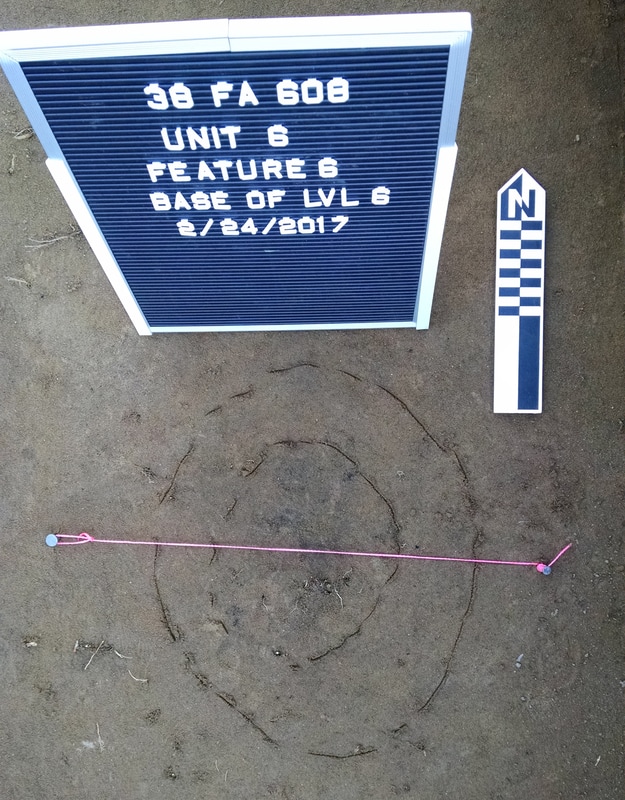
Feature 6 in plan view prior to excavation, with lines scribed for mapping. The inner zone of the feature consisted of a circular/elliptical stain that contained a moderate density of charcoal. The outer zone was probably a "bleed" area created by natural processes (worms, insects, and roots) mixing parts of the feature with the surrounding sediment. The nails and string mark the line along which the feature will be excavated and profiled.
As you can see from the photo above, Feature 6 was a rather unspectacular stained area that contained a moderate amount of charcoal. We used standard feature excavating techniques to document and remove the feature: (1) mapped and described it in plan view; (2) bisected it to expose a profile, screening the sediment through 1/4" mesh; (3) documented the profile; (4) removed the remaining portion of the feature as a flotation sample. There wasn't much cultural material in the feature, but there were lots of large chunks of charcoal. In profile the feature appeared to be a shallow basin with a fairly regular shape, and there was no evidence that it was a root stain or rodent burrow.
Picture
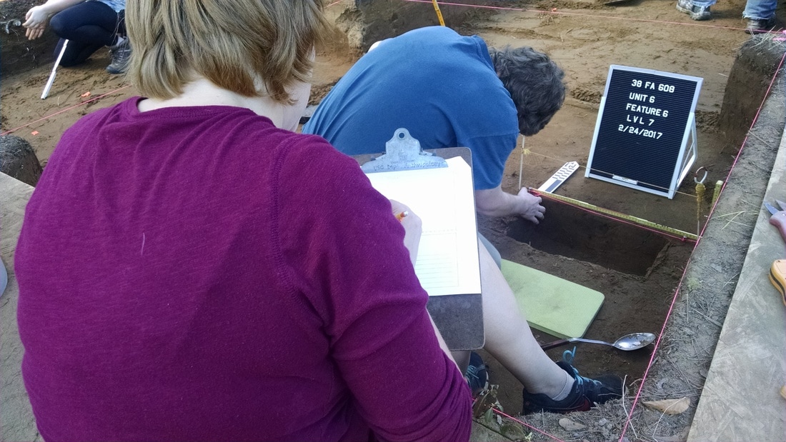
Students excavating and documenting Feature 6.
The excavation to expose Feature 6 in profile went down to about 90 cmbd (centimeters below datum), so that seemed like a good target for the bottom of level 7 in Units 4 and 6. By the end of the day, Unit 6 was well on the way to being there, with no sign of cultural features. We're using a shovel-scraping methodology that, hopefully, strikes a good balance between speed and control. I want to go slow enough to recognize cultural features if they're present, but fast enough to end up with some good data on what we're dealing with as far as the horizontal and vertical distribution of prehistoric materials.
Picture
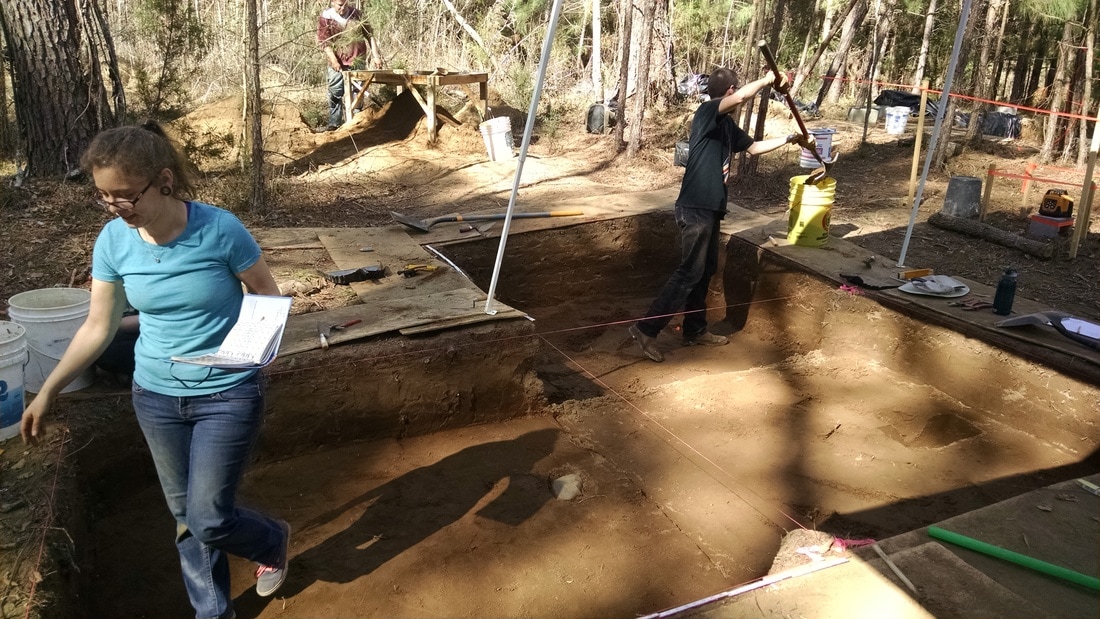
Work in progress in the block.
Meanwhile, Unit 5 -- the third 2m x 2m unit in the "upstairs" block -- finally got to the base of Zone 2. If there was any remaining doubt that Zone 2 was plowed, those doubts were removed by a large stone exposed at the interface of Zones 2 and 3 in Unit 5.  This rock -- the biggest one I've seen at the site so far -- was undoubtedly brought to the site by prehistoric peoples. While the rock is resting securely in situ in Zone 3 sediments, its top has been sheared off and scraped multiple times by a plow (individual plow scars are visible). If there was ever "smoking gun" evidence of plowing, this is it.
Picture
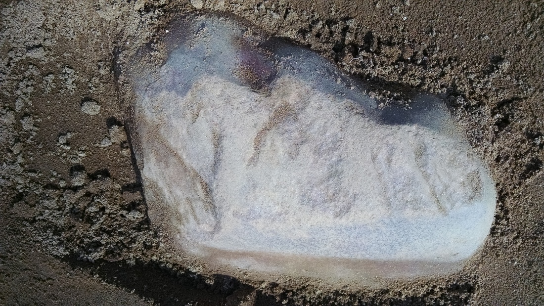
Large rock at the interface of Zones 2 and 3 in Unit 5. The rock is in situ, and the top has been scraped by plowing.
Meanwhile, in the "downstairs" portion of the site, work resumed on the excavation of Unit 9 (the 1m x 3m unit placed to extend the profile wall. As excavations near the top of the (supposed) Middle/Late Archaic zone, Jim Legg dazzled the students with yet another paisley shirt. Work also continued in Unit 7, a 1m x 2m unit being excavated to explore what lies beneath the exposed profile.
Picture
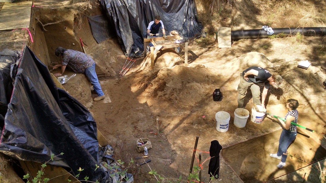
Work in progress in Unit 9 (left) and Unit 7 (lower right).
The last level of Unit 7 contained very little material. It did reveal, however, that the lamellae (the dark bands of sediment caused by the downward migration and accumulation of clay particles) appear to end rather suddenly. The base sediment remains coarse sand. It's possible that the abrupt ending of the lamellae is telling us something about the level of the water table: saturated sediment would presumably not facilitate the downward migration of clay particles. This will be something we can investigate with sediment analysis once we've got a nice profile exposed that we can sample. In the meantime, I've got my fingers crossed that we don't get a significant rainfall that presses the pause button on Unit 7.
10 Comments
Bob Jase
3/1/2017 09:05:32 am

You didn't say you were excavating Celtic sites in the US - that's clearly a Barry Fell approved sample of Ogham you've posted.

Reply
Andy White
3/1/2017 09:35:33 am

This is my reward for devoting a portion of my blogging time to nonsense.

Reply
Jim
3/1/2017 10:03:38 am

Keep your eyes peeled, you are right in the Roman sword zone !

Andy White
3/1/2017 10:32:40 am

Tough crowd here today.

Mike Morgan
3/2/2017 02:06:22 am

OH! You could have some fun with this rock by posting it on Ancient Origins or JHP Facebook pages using JHP's favorite caption for photos of rocks "What say you?"

Jim
3/1/2017 11:49:22 am

On the blue and white scale thingamabob, what is the scale ?

Reply
Andy White
3/1/2017 12:57:55 pm

The small divisions on the north arrow are centimeters.

Reply
David Allee
3/2/2017 07:19:21 am

I really appreciate this series of blog entries. They allow me to watch a dig without getting in the way. Thank you.

Reply
E.P. Grondine
3/10/2017 11:11:51 am


Hi Andy -
"The last level of Unit 7 contained very little material. It did reveal, however, that the lamellae (the dark bands of sediment caused by the downward migration and accumulation of clay particles) appear to end rather suddenly. The base sediment remains coarse sand. It's possible that the abrupt ending of the lamellae is telling us something about the level of the water table: saturated sediment would presumably not facilitate the downward migration of clay particles. This will be something we can investigate with sediment analysis"

Your site is on a river. There should be occasional flooding.
The coarse sand and its depth are also of interest.
It may not be the "floor".

Reply
Jose S
3/15/2017 01:29:33 pm

"The rock is in situ, and the top has been scraped by plowing." It is clear to me that those Catholic Church agents and operatives from the BlackOps Section of the Smithsonian had a long talk with you. The rock shows, without a doubt, what are known as proto-Roman-Celtic-Norse runes. The question now is: What do those history deniers from the Smithsonian offer you or did to you in exchange for you miss-identifying the markings as plow scrapes. Did they too, make you leave a scale reference out of the rock image? Was it to hide the fact that it may very well be a land claim placed there by the same proto-Roman-Celtic-Norse Masons who wrote the runes? Why only show the top of the rock and not the sides? Was it the circular holes on the sides you and the Smithsonian operatives were trying to hide? That picture leaves a bunch of questions unanswered. So sad....

By the way, my comment above was intended as sarcasm.

Keep up the great work you're doing, Andy!

Reply


Leave a Reply.


    All views expressed in my blog posts are my own. The views of those that comment are their own. That's how it works.

    I reserve the right to take down comments that I deem to be defamatory or harassing. 

    Andy White

    Follow me on Twitter: @Andrew_A_White

    Email me: andy.white.zpm@gmail.com

    Enter your email address:

    Delivered by FeedBurner


    Picture

    Sick of the woo?  Want to help keep honest and open dialogue about pseudo-archaeology on the internet? Please consider contributing to Woo War Two.
    Picture

    Follow updates on posts related to giants on the Modern Mythology of Giants page on Facebook.

    Archives

    January 2023
    January 2022
    November 2021
    September 2021
    August 2021
    March 2021
    June 2020
    April 2020
    March 2020
    January 2020
    December 2019
    November 2019
    October 2019
    September 2019
    May 2019
    April 2019
    January 2019
    December 2018
    November 2018
    October 2018
    September 2018
    August 2018
    July 2018
    June 2018
    May 2018
    April 2018
    March 2018
    February 2018
    January 2018
    December 2017
    November 2017
    October 2017
    September 2017
    August 2017
    July 2017
    June 2017
    May 2017
    April 2017
    March 2017
    February 2017
    January 2017
    December 2016
    November 2016
    October 2016
    September 2016
    August 2016
    July 2016
    June 2016
    May 2016
    April 2016
    March 2016
    February 2016
    January 2016
    December 2015
    November 2015
    October 2015
    September 2015
    August 2015
    July 2015
    June 2015
    May 2015
    April 2015
    March 2015
    February 2015
    January 2015
    December 2014
    November 2014
    September 2014
    August 2014
    June 2014
    May 2014
    April 2014
    March 2014

    Categories

    All
    3D Models
    AAA
    Adena
    Afrocentrism
    Agent Based Modeling
    Agent-based Modeling
    Aircraft
    Alabama
    Aliens
    Ancient Artifact Preservation Society
    Androgynous Fish Gods
    ANTH 227
    ANTH 291
    ANTH 322
    Anthropology History
    Anunnaki
    Appalachia
    Archaeology
    Ardipithecus
    Art
    Atlantis
    Australia
    Australopithecines
    Aviation History
    Bigfoot
    Birds
    Boas
    Book Of Mormon
    Broad River Archaeological Field School
    Bronze Age
    Caribou
    Carolina Bays
    Ceramics
    China
    Clovis
    Complexity
    Copper Culture
    Cotton Mather
    COVID-19
    Creationism
    Croatia
    Crow
    Demography
    Denisovans
    Diffusionism
    DINAA
    Dinosaurs
    Dirt Dance Floor
    Double Rows Of Teeth
    Dragonflies
    Early Archaic
    Early Woodland
    Earthworks
    Eastern Woodlands
    Eastern Woodlands Household Archaeology Data Project
    Education
    Egypt
    Europe
    Evolution
    Ewhadp
    Fake Hercules Swords
    Fetal Head Molding
    Field School
    Film
    Florida
    Forbidden Archaeology
    Forbidden History
    Four Field Anthropology
    Four-field Anthropology
    France
    Genetics
    Genus Homo
    Geology
    Geometry
    Geophysics
    Georgia
    Giants
    Giants Of Olden Times
    Gigantism
    Gigantopithecus
    Graham Hancock
    Grand Valley State
    Great Lakes
    Hollow Earth
    Homo Erectus
    Hunter Gatherers
    Hunter-gatherers
    Illinois
    India
    Indiana
    Indonesia
    Iowa
    Iraq
    Israel
    Jim Vieira
    Jobs
    Kensington Rune Stone
    Kentucky
    Kirk Project
    Late Archaic
    Lemuria
    Lithic Raw Materials
    Lithics
    Lizard Man
    Lomekwi
    Lost Continents
    Mack
    Mammoths
    Mastodons
    Maya
    Megafauna
    Megaliths
    Mesolithic
    Michigan
    Middle Archaic
    Middle Pleistocene
    Middle Woodland
    Midwest
    Minnesota
    Mississippi
    Mississippian
    Missouri
    Modeling
    Morphometric
    Mound Builder Myth
    Mu
    Music
    Nazis
    Neandertals
    Near East
    Nephilim
    Nevada
    New Mexico
    Newspapers
    New York
    North Carolina
    Oahspe
    Oak Island
    Obstetrics
    Ohio
    Ohio Valley
    Oldowan
    Olmec
    Open Data
    Paleoindian
    Paleolithic
    Pilumgate
    Pleistocene
    Pliocene
    Pre Clovis
    Pre-Clovis
    Prehistoric Families
    Pseudo Science
    Pseudo-science
    Radiocarbon
    Reality Check
    Rome
    Russia
    SAA
    Sardinia
    SCIAA
    Science
    Scientific Racism
    Sculpture
    SEAC
    Search For The Lost Giants
    Sexual Dimorphism
    Sitchin
    Social Complexity
    Social Networks
    Solutrean Hypothesis
    South Africa
    South America
    South Carolina
    Southeast
    Stone Holes
    Subsistence
    Swordgate
    Teaching
    Technology
    Teeth
    Television
    Tennessee
    Texas
    Topper
    Travel
    Travel Diaries
    Vaccines
    Washington
    Whatzit
    White Supremacists
    Wisconsin
    Woo War Two
    World War I
    World War II
    Writing
    Younger Dryas

    RSS Feed

    Picture
Proudly powered by Weebly