Andy White Anthropology
  • Home
  • Research Interests
    • Complexity Science
    • Prehistoric Social Networks
    • Eastern Woodlands Prehistory
    • Ancient Giants
  • Blog
  • Work in Progress
    • The Kirk Project >
      • Kirk 3D Models list
      • Kirk 3D Models embedded
      • Kirk 2D images >
        • Indiana
        • Kentucky
        • Michigan
        • Ontario
      • Kirk Project Datasets
    • Computational Modeling >
      • FN3D_V3
    • Radiocarbon Compilation
    • Fake Hercules Swords
    • Wild Carolina >
      • Plants >
        • Mosses
        • Ferns
        • Conifers
        • Flowering Plants >
          • Grasses
          • Trees
          • Other Flowering Plants
      • Animals >
        • Birds
        • Mammals
        • Crustaceans
        • Insects
        • Arachnids
        • Millipedes and Centipedes
        • Reptiles and Amphibians
      • Fungi
  • Annotated Publications
    • Journal Articles
    • Technical Reports
    • Doctoral Dissertation
  • Bibliography
  • Data

A New Paper on the Origin and Evolution of the Carolina Bays

3/18/2016

44 Comments

 
The post about the Carolina Bays that I wrote a couple of weeks ago turned out to be relatively popular (as far as this webpage goes, anyway). Carolina bays are elliptical depressions of varying size that occur along the Atlantic Coastal Plain in a band extending from New Jersey to Florida.  Their limited geographic distribution and northwest-southeast orientation has given rise to many ideas about how these features were formed. Ongoing debate centers around the question of whether the bays formed as (1) the result of impacts associated with an extraterrestrial object (e.g., debris ejected by a comet strike in Saginaw Bay) or (2) through the actions of wind and water during the Pleistocene. Extraterrestrial or terrestrial?
A new paper by Chris Moore and colleagues (see full reference below) in Southeastern Geology provides more evidence that the bays were formed and modified over long periods of time by natural, terrestrial processes. You can read the paper for yourself here.
The analysis in the paper focuses on Herndon Bay, a 1-km long elliptical depression in Robeson County, North Carolina. Using a combination of detailed surface mapping, ground penetrating radar data, geomorphological analysis, and age estimates obtained using OSL, Moore et al. show that punctuated migration of Herndon Bay to the northwest from about 41 to 24 thousand years ago produced a sequence of sand rims on the southeast side of the basin. The bay held its shape and orientation as it migrated over the course of thousands of years.
Picture
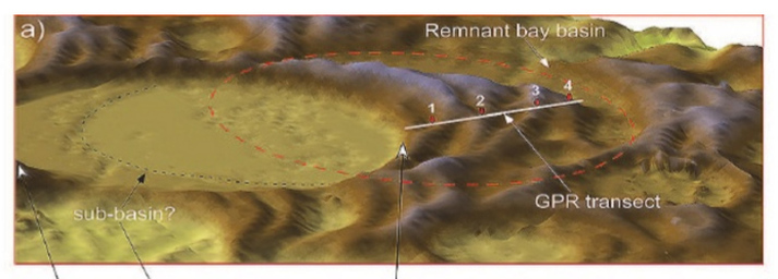
A portion of Figure 3 from "The Quaternary Evolution of Herndon Bay, a Carolina Bay on the Coastal Plain of North Carolina (USA): Implications for Paleoclimate and Oriented Lake Genesis." The numbers show locations of dated sand rims left by migration of the bay (4 is the oldest, 1 is the youngest).
The evidence and analysis that Moore et al. present is a pretty strong argument against the idea that the bays were formed by a single event (i.e., an extraterrestrial impact).  I encourage you to take a look at the paper.  I'll just paste in a paragraph from their conclusion (pg. 168):
"The characteristics of Carolina bays, including basin shape, changes in basin orientation with latitude, and sand rims reflect long-term and pervasive environmental, climatological, and hydrological factors over millennia rather than from sudden or catastrophic events (Kaczorowski, 1977; Thom, 1977; Carver andBrook, 1989; Brooks and others, 1996; Grant and others, 1998; Brooks and others, 2001;Ivester and others, 2007, 2009; Brooks and others, 2010). The fact that practically all Carolina bays in a particular geographic region have nearly identical patterns of shape, orientation,and sand rim composition suggests similar processes working over long periods of time. This study also indicates that Carolina bays can respond rapidly, and appear to become more active during periods of climatic instability. While many nuances of bay evolution remain to be re-fined, the evidence at Herndon Bay clearly supports the concept that Carolina bays represent a regional example of a globally-occurring phenomenon: They are wind-oriented lakes shaped primarily by lacustrine processes."

Reference:
Moore, Christopher M., Mark J. Brooks, David J. Mallinson, Peter R. Parham, Andrew H. Ivester, and James K. Feathers. 2016. The Quaternary Evolution of Herndon Bay, a Carolina Bay on the Coastal Plain of North Carolina (USA): Implications for Paleoclimate and Oriented Lake Genesis.  Southeastern Geology 51(4): 145-171.

Addendum (3/18/2016):  Let's start over with the comments. Please keep comments on the topic of the blog post (Carolina bays) or I'll delete them.
44 Comments
Sharon Hill link
3/18/2016 08:51:57 am

The extraterrestrial hypothesis has been in death throes for a while. You noted in your last post that it has little support; there is NO evidence that current supports the comet or asteroid idea. But it is SO interesting that it won't die. Typical.

Reply
SteveGinGTO
3/19/2016 05:05:37 am

Actually, Sharon Hill, ALL of the hypotheses for the formation of the Carolina bays have failed at every turn - and that includes aeolian. Douglas Johnson thoroughly vetted them all half a century ago, and every generation of aeolian scientists keeps resurrecting it and not adding one iota of good evidence.

Picking out ONLY the impact hypothesis and sayin IT failed, is disingenuous of you. You KNOW that the others don't hold water, either. But you JUST happened to leave that out, didn't you?

Moore here, for example. He takes a transect of an OBVIOUSLY reworked (windblown) bay rim - the only part of that bay rim with FOUR ridges - 3 aeolian and who knows about the inner one (the real bay rim). And he takes OSL test samples FROM THE REWORKED part for dating? Having been windblown, who knows where they came from?

This is all a rehash of Moore's 2014 work. Why is it being brought up now? What? He recycled it?

Reply
T.H.S. Harris link
3/25/2018 05:43:59 pm

Several points that clear up many of the question above:

Looking at this depositional Carolina bays unit geologic formation for some years now, a few points have become very clear. The giant sand blanket contains roughly 1600 cubic km of angular grained allochthonous highly fractured pure quartz sand (2 to 10 meter thick layer over ~400,000 sq km) draped over several unrelated ancient antecedent surfaces, containing no biotic detritus, the depositional blanket formation spanning a range of altitude from roughly 10 meters below sea level to roughly 600 meters ASL.

Very oddly, the formation has recently been linked to molecular hydrogen seepage that increases in concentration where the sand layer is thicker (Zgonnik et al, 2015 https://progearthplanetsci.springeropen.com/articles/10.1186/s40645-015-0062-5 Figures 2 and 4?). Sadly no measurements were taken beneath the lower contact of the sand unit due to shallow depth constraint of the hand driven tube auger technique used by Zgonnik et al (2015) (personal conversation).

Why would allochthonous, nearly pure quartz sand be angular-grained while at the same time covering nearly half a million square kilometers here on Earth (transport means)? Why would so much sand, roughly 3 x 10^18 grams, be highly fractured? Why on Earth would such a huge volume of extremely unique sand lack any and/or all sorts of biotic detritus, especially if that unit sand blanket is envisioned as being of lacustrine/Aeolian origin having formed over millennia? Wind and wave is a complete fail in this regard, just as a point of order in the larger conversation. Lets stick to mechanics that explain the observable imprint, not imaginations that we project or hope to be an answer yet fail to deliver any factual, mechanical possibility of generating the observable imprint.

I’m afraid I have a prejudice, and I will definitely not consider “…fish nests… “ as a possible cause or origin for the Carolina bays. But my prejudice is actually because of the evidence. There is no biotic detritus in the bulk volume of the sand formation in which the oval depressions of the Carolina bays are formed, so fish nests are right out. And as far as acidic conditions within the sand that may decompose any biotic detritus, lets have a close look at the basal contact of the sand unit to see what is in the clay or other marginal indications of those contacts and figure out what has percolated within.

Sometimes the imprint isn’t easy to explain, or is uncomfortable to our consensus thinking. In these times, we must tread carefully in planetary impact science. To fail any viable explanation for tektites, for example, may be to fail our species in terms of a safe future. If I don’t want to believe a 100 km comet could have hit the Earth less than a million years ago, during Human evolution, killing Java Man in Indonesia and possibly initiating Earth’s most recent complete geomagnetic reversal, then I should be allowed to “stick my head in the sand” and blame it on fish nests. But this may be a grave injustice to wrought upon our offspring or future generations of Earth, a major “fail” or “Fail”.

Rager et al (2014, https://faculty.unlv.edu/wpmu/smithe/files/2014/05/Rager-Smith-Scheu-Dingwell-EPSL-for-wordpress.pdf, specifically Fig. 10) explains clearly how rapidly decompressed hydrated sandstone will explode from the inside, or auto-comminute, under the proper conditions when pore water flashes to steam and fractures the rock from within. This “steam wedging” or “endogenic comminution” is studied in volcanology where volatile-infused boulders sometimes self-disintegrate shortly after expulsion from the tube or vent. There may be some good material science and stress analysis science developments upon micro-mechanical exam of Carolina bay sand.

Rager et al (2014) demonstrates that only 15 MPa of rapid adiabatic depressurization without any prior shock at all is enough to cause explosive disintegration of hydrated porous sandstone with fines reaching the highest speed, and ballistic coefficient determining the lethargy or activation of comminuting aggregate as it becomes entrained within the volume of newly formed steam (former pore water). So impulsive removal of an ice sheet overburden via oblique impact, in a sub-horizontal or nearly tangential direction relative to the surface, would expose competent substrate bedrock to rapid decompression according to the depth of ice removed.

Any pore water within that rock would then be rapidly changing phase and expanding by a volume factor of roughly 1600-to-one. For every 1 km of ice sheet impulsively removed, we may expect on the order of 100 or a few hundred meters of comminuting bedrock, depending on its constitutive parameters, pore water content and initial temperature. Steam wedging typically causes failure in tensile fracture, a

Reply
T.H.S.Harris link
3/25/2018 07:24:45 pm

tensile fracture, an enormously energetic and extremely high-speed form of failure, which according to Rager et al (2014) would propagate through the bulk volume at rarefaction speed, much faster than the time scale of subsequent auto-excavation following initial bulk fracturing. Is this what happened to the “missing overburden” of the Michigan Basin?

Most of all in my mind, why is such a huge body of otherwise already very curious and unique sand apparently seeping hydrogen!?! It would seem that upon exploding up out of the ground when the ice sheet was impulsively removed from the overhead, some sandstone became entrained in shocked expanding ice sheet mass, in the form of steam plasma, and was accelerated to 3.5 to 4 km/s in order to reach the indicated coverage of the Carolina bays. Clearly there needs to be collection, characterization and comparison of Carolina bays sand from well-specified and well-controlled sample sites within the complex structure of the Carolina bays depositional sand blanket, and those sites should cover as wide an area as possible within the identified extant range of the unit formation.

If the sand was plasma infused during steam plasma transport, the energy required to do that on the observed scale is clear signature of astronomical KE partitioning. It couldn’t have been volcanism, and no, it couldn’t have been lightning either, although lightning gets closer to the required temp. In this case the indicated plasma infusion of hydrogen or hydroxyl into pure quartz has produced molecular hydrogen concentrations of 1000 ppm or more in the bulk sand blanket, observable 789 ka after emplacement of this imprint (Zgonnik et al, 2015 linked above). Light gas detection of H2 should be a first screening once the bulk unit is identified in the column and/or core, as a pass/fail for potential astronomic involvement. D/H ratio of such hydrogen is also of interest.

Impact Structures and KE Partitioning

Impact structures vary in character depending on conditions of the impact, including bolide definition, target definition, and approach speed & angle. Schultz and Gault (1990), Stickle and Schultz (2012?) and others have shown that oblique impact and volatile target overburden can both shield competent substrate. This is especially true when the overburden thickness nears or exceeds bolide diameter, to the extent that eventually over a range of the possible conditions, no detectable damage occurs to the competent substrate at all. So the case for a subdued expression in a large impact event is not impossible or unimagined by any means if there is volatile overburden involved at the target.

During MIS 20 at the time of the Australasian (AA) tektite event (789 ka according to recent high precision Ar/Ar dating), the ocean was at a low stand and there would have been thick polar ice. Additionally, the shallow ovoid depressions in the sand blanket known as the "Carolina bays" are displaced laterally from their presumed centerline, as well as being displaced down range from the presumed region of contact of bolide with the ice sheet. This is the expected imprint for an intermediate player in the KE partitioning of the impact (i.e. ice sheet) that would have absorbed plenty of down range momentum in the initial partitioning. The Carolina bays unit geologic formation has elements of both "butterfly wings" pattern of oblique impact as well as a down-range component of oblique momentum adsorption, all relative to their implied source of Lake Huron based on its location and orientation.

Regardless of what one is able to grasp as a possible impact structure or not, a few things remain true in the overall planetary impact paradigm. Mainly, its going to leave some kind of mark, even if competent bedrock is largely shielded by involvement of ice overburden. Continuity of partitioning should leave its imprint on every component that is affected by that process. Any cosmic impact formative mechanism for the Carolina bays, or any proposed impact structure for the AA tektites, must show evidence of continuity of partitioning that is commensurate with the scale of KE being partitioned, or must explain why gaps in that continuity exist (missing volatiles no longer present, etc.)

The bay plan forms correspond identically to (suborbital) ballistic targeting diagrams, or circular error probability ellipses. All 50,000+ of the ovoid depressions in the enormous sand blanket conform to just 6 of these archetype ovals ("Davias Archetypes"), each a slight variation of a mathematical ellipse.

"Suborbital Obstruction Shadowing" (T.H.S. Harris 2015, GSA National Mtg, Baltimore) (https://gsa.confex.com/gsa/2015AM/webprogram/Handout/Paper260536/SUBORB OBSTRUCT SHADOW GSA2015 Harris Small.pdf) and
(https://gsa.confex.com/gsa/2015AM/webprogram/Handout/Paper260547/Suborb Obstruct Shadow %26 Transport Imprint Matching XML 2015 GSA Baltimore Handout THSHarris.pdf)
explain

T.H.S. Harris link
3/25/2018 08:10:27 pm

explain how variable impedance to volatile outflow with entrained aggregate (comminuted target mass) becomes imprinted as variable flux patterns of the aggregate within the outflow. Hypersonic bow shock leaves a lower flux of entrained aggregate in the wake of a larger obstruction within the flow (ballistic coefficient of obstruction >> that of entrained aggregate particles) and an increased flux of entrained aggregate in a cone around that wake. That flux pattern is then convoluted by suborbital mechanics during exoatmospheric transport, to eventually become emplaced as the Carolina bays sand blanket having shallow oval depressions with shallow elevated rims or partial rims, or sometimes just no rims at all. Rims or not, the regional Davias Archetype planform is always adhered to regardless of the physical scale of a given expressed bay depression.

These are principals also detailed in "Proximal Bodies In Hypersonic Flow" (S. J. Laurence, 2006 PhD Thesis, https://thesis.library.caltech.edu/1490/1/sjl_thesis.pdf) and S. J. Laurence et al 2016, http://elib.dlr.de/78383/2/ludwieg_surfing.pdf, especially Fig 5!) which clearly shows how the Carolina bays formed their thousands of cases of adjacent overprinting. No other formative mechanism ever proposed can explain these or other features within the Carolina bays unit geologic formation. Laurence (2006) and Laurence et al (2016)

Using the same type of Suborbital Analysis (SA) that develops basic target error ellipses, a small perturbation of velocity “VEL” alone is able to match each Davias Archetype from the same circular section about a nominal trajectory that gives the mathematical ellipse. The required delta VEL for imprint matching of the Davias Archetype plan forms is roughly 1 to 3 parts in ten thousand for the indicated transport ranges of 800 to 1200 km. The bays themselves, shallow ovoid depressions in the upper contact of a shallow-buried sand blanket, range in physical scale from a few hundred meters to several kilometers in major axis length. Their size distribution follows a log normal distribution (https://en.wikipedia.org/wiki/Log-normal_distribution).

The Davias Archetype groups each have log normal distributions of physical scale, with the Nebraska or Bay WEST Davias Archetype being the largest and topping out at around 7 km in major axis length. Here is a critical clue to the mystery of the Carolina bays: the plan forms are the same by geographic region, no matter the expressed scale of any single give single physical example or instantiation. This implies that the imprinting of Davias Archetype must have been in early or ascent phase of suborbital transport, i.e. such that all copies of Suborbital Obstruction Shadowing imprinting within the outflow from the event are set or cast the same within the flow for a given segment of the outflow field (and thus for a given geographic region of where those sets of similar copies eventually land and become emplaced).

A “simple” interpretation is that the Davias Archetypes represent (clearly) gradients of the event outflow that became imprinted into the map of variable aggregate flux within that flow, subsequently convoluted by the governing suborbital mechanics (after rarefaction of the outflow and the setting of the aggregate upon its suborbital path), and finally emplaced as the information-laiden “process snapshot” that is now the Carolina bays unit geologic formation. Maybe its only clear if you’ve studied perturbational suborbital mechanics and some other topics relating to the many features presented within the “process snapshot” of the Carolina bays, hydrogen seepage among the more extreme and otherwise unexplainable (Zgonnik 2015 linked above).

Regression analysis of launch conditions for the sand of the Carolina bays unit geologic formation using Suborbital Analysis indicates that the comminuting substrate that is now the sand of the blanket came out of the ground in the Great Lakes area in great jetting geysers. The velocity profile for clustered groups of common-shaped bays is a match for transverse fuel injection into hypersonic scram jet internal flow before ignition. Across the landscape over what is now Lake Michigan, over great radial swaths extending from what is now the Saginaw Bay of Lake Huron on the other side of the Lower Michigan peninsula, rudely unveiled bedrock from deep beneath a violently removed ice sheet erupted into supersonic vertical columns.

Davias and Harris (AGU 2017 Fall Meeting) demonstrates the scale of the Carolina bays (https://agu.confex.com/agu/fm17/meetingapp.cgi/Paper/236973) unit geologic formation with a LiDAR enhanced regional image that makes up a mere 0.15 of one percent (yes, only 15 ten-thousandths) of the overall depositional blanket. The counterpart e-poster to the abstract (https://agu.confex.com/agu/fm17/mediafile/Handout/Paper236973/AGU 2017 Davias Harris P11A

T.H.S. Harris link
3/25/2018 08:12:55 pm

The counterpart e-poster to the abstract (https://agu.confex.com/agu/fm17/mediafile/Handout/Paper236973/AGU 2017 Davias Harris P11A-2499 ePoster.pdf) illuminates many remarkable details regarding the vast sand blanket and ovoid depressions imprinted within. The size of peak occurrence is essentially independent of emplacement elevation above sea level, another signature of “suborbital delivery” or non-terrestrial transport process.

Harris and Davias (AGU 2017 Fall Meeting) interprets apparent KE partitioning in (https://agu.confex.com/agu/fm17/mediafile/Handout/Paper205863/AGU 2017 Harris Davias P11A-2496 ePoster.pdf), with left column for Australasian tektites, mid-left column for Carolina bays, and right column for KE partitioning over the North American Great Lakes region. Mid-left Carolina bays column shows Bay BELL Davias Archetype Suborbital Analysis (SA) results geographically, with “photo-proof” montage of parametric comparisons for trending. VEL vs AZ photo-proof frames “C” & “Cprime” show “savannah” effect of slanting clusters of points, each point representing the solved launch condition of a single Carolina bay depression. Other Davias Archetypes show a similar pattern, all matching expanding hemispheric plumes that march down range per Schultz & Gault (1990).

Both of the AGU 2017 posters give plenty of food for thought, and hours spent pondering finer details of each may prove rewarding to the careful observer. Startling revelation and outright fright may be overcome with the assured confidence that we are still here today as a species to talk about it, so the message is not entirely without its “good news” portion. The “bad news” portion is that we don’t know what the ricochet portion of the bolide may have been, or its overall size or region of origin in the heavens. We do know that all heliocentric components of ricochet would be, by definition, Earth crossing, after this event. Other elements of the Great Lakes imprint to the N.E. of the Georgian Bay of Lake Huron indicate a 100 km diameter low-density comet. Wake up….

The “savannah” clustering of launch condition parameters in Harris and Davias (AGU 2017 Fall Meeting linked above) reflects a pattern of that phase of the transport process. The sand was ejected from a “moving train” that had swept it up, i.e. the central momentum current of shocked ice. As that momentum current of warm dense matter rarefacted and radiated sand in the process, it was translating down range from the impact footprint, i.e. from N.E. toward S.W. In the VEL vs AZ plot clusters, higher VEL has higher AZ within a given cluster along the East Coast portion of the Carolina bays formation. Clusters turn out to represent roughly neighboring but never adjacent or even nearly adjacent emplacements, all having nearly identical launch conditions and rigidly systematic nearly identical launch location, “slightly translating”.

The launch of the sand itself from the ground would have been as if from simple springs, but on a planetary scale. It was a machine of impossible energy to comprehend. Hundreds upon hundred of cubic kilometers of bedrock sprang from the Earth and “rapidly fled” the area in under a minute, jumping to speeds of 3 and 4 km/s in just a few moments during departure. Vertical columns of comminuting bedrock were at once swept sideways by hypersonic outflow of shocked ice sheet as the latter and far greater mass developed its own momentum flow during its own release from astronomically strong shock. The surface and the sky became one dark mixture of pulverized and highly heated mass, all with the same intent to seek solitary space near no other neighbors. Rapid egress from the terrestrial setting became the reigning regional decree, with all inhabitants be they mineral, vapor or plasma, ordered to comply in great haste.

Beyond this the picture isn’t entirely clear yet. Somewhere along the path of expansion for shocked ice sheet (10s of thousands of cubic km of shocked ice all looking to expand by 1600-to-one), in the more horizontal margins of that massive outflow, with huge volumes of entrained aggregate comminuted substrate bedrock formerly from beneath the ice sheet, the flow encountered blocky obstructions. The large or blocky obstructions were further horizontally from the core of the impact-induced shocked ice momentum current, more distal and/or more down range from the core current, than was the origin of the sand. Shocked ice seems to have already imprinted the astronomically large momentum of KE partitioning by the time the sand became entrained. At that point, a tiny fraction of the overall momentum contained within the shocked ice was partitioned yet further to accelerate the sand horizontally as it came out of the ground vertically. The impedance of this overall mass

T.H.S. Harris link
3/25/2018 08:14:46 pm

The impedance of this overall mass transport scheme is born within the Carolina bay imprint, in many different ways.

The shocked ice sheet mass with entrained aggregate gained speed and was already supersonic or hypersonic when the blocky obstructions were encountered. Some of these obstructions were apparently encountered above the atmosphere after rarefaction of the shocked ice (steam plasma). Upon encounters with the large or blocky obstructions, aggregate was deflected along with the bow shock wave at each obstruction. A lower aggregate flux was left within the roughly conical wake volume of each obstruction. Around the perimeter of each obstruction’s wake volume, or on the surface of the “wake cone”, the bow shock forcing effect would have increased the flux of aggregate. Thus the pattern of the Carolina bays was initially imprinted by the complex process of KE partitioning after oblique astronomic impact into ice sheet overburden. Transport of the sand was secondary partitioning, not primary partitioning, thus leaving no significant shock metamorphism within the bulk mass of involved sand. But plasma leaves a mark.

Released upon rarefaction of the steam plasma outflow, this imprinted pattern of aggregate flux would reach emplacement in a set of shallow ovoid depressions, possibly with or without shallow elevated rims, all comprised of the same aggregate. Post-rarefaction imprinting would result in no elevated aggregate flux around the wake cone and therefore no elevated rim around an emplaced bay, all due to lack of gas dynamic interaction, but rather to masking effect only. Emplaced aggregate from this process would be expected to show 1) characteristic damage from “internal fracking” or steam wedging from rapid decompression of hydrated porous rock, 2) lack of significant or substantial erosion or rounding of grains from terrestrial transport means, and 3) steam plasma infusion imprinting of some kind depending on the severity of entrainment conditions. Not coincidently, the Carolina bays seem to tell this story quite clearly.

In terms of probability, there can be no doubt. 50,000+ samples following this mechanical model is neither accident nor coincidence. It is a large sample size “n”, and the convolution of gas dynamics (from variable impedance imprinting) with suborbital mechanics to consistently produce the observed result within the Carolina bays imprint make any other combination of random or “coincidental” causes virtually impossible in this case. The probability varies with positive “n” in the exponent that a governing suborbital transport model is substantially correct, or negative n in the exponent that such a model is incorrect.

I think that the state of the sand and its huge volume are the keys to identifying an ET source process for the emplacement. Presence of hydrogen indicates the sand is what we should be looking at, and the fractured, stressed and relatively un-eroded state of the depositional blanket of sand, along with its unusually high volume and extensive geographic coverage, tell us the extraordinary degree to which the process must have taken place, i.e. the extent of the KE partitioning. The event was a large yield, perhaps larger than the Chicxulub event.

When accounting for inefficiencies of entrained transport, I believe this event may easily have had a larger yield than the Chicxulub event, by a factor of 1 to 3 orders of magnitude. Plasma infusion alone into quartz sand, to an extent still detectable after 789 ka, is an indication of an astronomically energetic process, especially when observed over the scale of the Carolina bays unit geologic formation.

Adam Glass link
4/8/2018 09:26:17 pm

Hi Mr. (Professor) Harris:

I was googling to find a slide Michael Davias put up that has examples of his six CB archetypes on a single slide (actual LiDAR images not diagrams). No luck there but I found your post and have bookmarked it for later reading. You must be his co-author on the Saginaw Impact Manifold paper. I look forward to reading more of your work. Regards, ADAM

SteveGinGTO
3/19/2016 04:57:05 am

WTF? That article is about the work of Christopher Moore and it looks like a rehash of the same STUFF that he pandered 2 years ago.

His transects of Herndon Bay - Seriously, WHY, with all the single bay rims around does Moore transect the portion of a bay rim that has FOUR ridges? He cherry picked it because it is a reworked rim. Reworked by the aeolian processes he pushes.

How much mileage is this guy going to rty to get out of that? 45,000 bays and he chooses one that is a Goldilocks on for him(so he thinks).

"Ongoing geomorphological fieldwork at Herndon Bay in northern Robeson County, North Carolina, has revealed evidence for rapid bay basin scour and landform migration. LiDAR data show a regressive sequence of sand rims that partially backfill the remnant older bay basin, with bay migration of more than 600 meters to the northwest. Similarly, other bays in the region show evidence of significant migration."

See? Migration means REWORKED. Reworking has NOTHING to do with initial bay formation.

Then:
"A series of Geoprobe® cores (n=4), basal OSL samples (n=3), and GPR data were collected along transects that cross-cut multiple bay sand rims along the bays southeastern margin. Cores were subsequently analyzed to determine basic lithologies, grain-size statistics of lithologic units (i.e., lithofaces), and magnetic susceptibly. These data, along with GPR data and OSL age estimates are used to reconstruct landform geomorphology and provide a geochronology for bay rim development."

He takes REWORKED, MIGRATED "rims" and does OSL dating on them? Are you KIDDING? The "single grain" samples used in the OSL tetsting showed dates of 36.7kya, 29.6kya, and 27.2kya. Those single grains in wind-drifted turbulated sand rpofiles OUTSIDE the bay itself - THESE are what he uses for dating the bay formation?

Did he get his PhD out of a box of Cracker Jacks?

No. The man has an agenda, and he cherry picks his samples to fit his pre-conceived notions.

Really bad science.

Reply
Shane Miller
3/19/2016 08:49:50 am

Never thought I'd see someone troll this hard on a post about Carolina Bays. Sheesh...

Reply
SteveGinGTO
3/19/2016 10:27:13 am

It's not trolling to have a different opinion. NONE of the explanations that have been tried work - and you know that. And you only accept comments supportive your failed and failing explanation.

So you namecall someone with a different POV.

Moore's work is WEAK.

E.P. Grondine
3/23/2016 07:56:01 pm

Steve (Garcia) -

Your comment here on the Bays is as irritating as your estimates of plasma and vapor formation in hypervelocity impacts - and as pompous.

Those who are working with the geology of the coastal Carolina's are looking at impact and seismic tsunami sediment deposits.

Don't ask me who, as they really do not have the time to straighten you yourself out.

Do not ask me about my sources, as I will simply ignore your requests. Period. End of discussion.

Steve Garcia
4/2/2016 02:11:42 am

Ed -

Are yous still making enemies everywhere you go?

Insulting everyone?

Still pretending to be a scientist instead of an out-of-work journalist?

Steve Garcia
4/2/2016 02:13:57 am

Ed -

You don't have sources. They all got tired of your sad, self-loathing, miserable attitude.

Shane Miller
3/19/2016 12:31:20 pm

Well, my opinion is that Chris Moore is one of the brightest and most methodical geoarchaeologists in eastern North America, and his publication record speaks for itself. He does a great job of following where the data takes him.

Also, he's a co-author on several papers actually supporting elements of the impact hypothesis. It's not like he has a track record of cherry picking the data to create a one-sided critique on this issue.

Reply
Bill Wagner
3/31/2016 07:59:34 am

Entertaining reading here in the peanut gallery.

45,000 features too similar and (in number) unique to have resulted from various other-than-impact in the same area. Add the prospect of additional, larger ones currently under the Atlantic. Add the apparent population crash in that area at the end of the Early Archaic (such as would be an expected result of such bay-producing impacts). Add the tradition of the local NAs (who were maintaining precisely this scenerio long ago and style themselves "the People of the Falling Star").

It would be surprising if these "adds" did not, in the end, "add up" as three facets (impact, effect, memory) of one coherent picture.

Reply
Andy White
3/31/2016 11:42:47 am

There's just the inconvenient problems that the Carolina Bays date to many different times (suggesting a common process over time rather than a single event) and were in existence prior to the Paleoindian period.

Reply
Steve Garcia
4/2/2016 02:19:25 am

Actually, the differnt dates is because no one has figured out where to properly take samples for C14 or OSL. The bays are secondary impacts from Michael Davias' Saginaw Bay impact site, which, though about 1,000 km away is mathematically tied to the 45,000 bays - ALL of them. Aeolian can't explain that, because aeolian is a local phenomenon.

Aeolian was discarded back in the 1950s, and anyone doing that work nowadays is trodding on ground that has been shown half a century ago to be not tenable.

Moore had to cherry pick not only a certainly wind-re-worked bay, but the portion of the rim most obviously wind re-worked.

Michael Davias link
2/1/2018 05:18:44 am

The temporal aspects of the Carolina bays are confounded by the historical lack of adequate dating technologies. The sediments in the bays were sampled as long ago as the 1930s using pollen, and it showed the passing of at least one glacial cycle, and perhaps several. When Carbon dating became available, deep bay samples were listed as ">50ka", not because they were 50k old, but they were older than that. 50ka is the limit of that isotope's abilities. Then we received the OSL technology, so well adapted and applied to Moore's and Iverster's archeological work. When they got down deep, they started reporting >120ka, because that is where that technology peters out. My hypothesis suggest they are far older still, and now we can bring to the table the beryllium/aluminum isotopic burial dating, that reaches back 5 million years. If there is any merit to the hypothesis, we will see burial dates for the sediments beneath the rim sands to have been buried 800ka. Be10/AL26 dating has already found the existence of a mid-plicotocene "regolith injection" in glacial tills and cave sediment deposits. We must be carful to distinguish between true bay rim formations and the surficial layers of eolian and fluvial sediments blanketed over the rims in the intervening 800,000 years.

J. Hoekendijk
4/11/2016 04:31:23 pm

Electrical scarring? All mechanical erosion models fail since bays formed to the same depth independent of formation. That is ... hard and soft formations have same depth rather than differing depths. Thus ... mechanical processes seems very unlikely. That leaves 'other than mechanical' sources. How ... I don't know. The consistent orientation and differing bay ages suggest, to me, of a periodic extraterrestrial encounter with object(s) and electrical interaction.

Reply
Andy White
4/11/2016 05:19:37 pm

Where are you getting that they're all the same depth? Everything I've looked at suggests they vary from seasonal marshes to open water.

Reply
Steve Garcia
4/11/2016 06:05:07 pm

Andy, thanks for catching that. I've never heard the same depth thing. I doubt anybody has ever measured them, and re-working would have made them unequal over time, even if they started that way. Which I don't think is true, either.

Steve Garcia
12/30/2016 11:20:46 pm

Andy - Actually, Micheal Davias (cintos.org) is the guy who has done LIAR on all the 45,000 CBs, and the LIDAR itself should be able to show the depths of the CBs. Like the dating samples, I imagine peoplw will be measuring from all sorts of different places on the rims, allowing them to claim all sorts of things about equal depths or unequal depths, whichever suits their preferred interpretations.

Michael Davias link
2/1/2018 05:29:03 am

There is a slide show on my website that displays over 400 maps of LiDAR-measured elevation transects crossing bays. Of course, this only shows the bay floor to rim relief, and currently hydraulically closed bays are know to have deep sediment fill. Most relief is under 3 meters, but I've seen 10 m from basement of rim to surficial rim. Try MPTimpact dot org /CB/EPmaps/, and give it some time to set up.

Steve Garcia
4/11/2016 06:03:38 pm

Nope, not an EU guy. Sorry to disappoint.

"How - I don't know" is what everybody should be saying. Still not enough information, not enough evidence to support any and contradictions to pretty much all of the ideas. Since the 1940s, they've all come up short and been contraindicated.

Electrical is probably the dumbest of all, because there would be fulgerites everywhere and it would be a no-brainer. Without them, the idea is a non-starter.

Reply
Andy White
4/11/2016 04:48:45 pm

So nobody knows how to date sediments (because the bays date to many different times). . . and the multiple concentric rims are just an inconvenient anomaly . . .

What is the positive evidence for an extraterrestrial impact origin other than "they look kinda like craters"?

Reply
Steve Garcia
4/11/2016 07:04:31 pm

Sampling in a uniformly stratified region would make C14 and OSL easy. Somehow that hasn't happened. You can put it as different ages. That would be one suggestion. Or if the sols were turbulated, who knows WHAT one would get for dates.

I don't have direct access to academic papers, so I can't find enough information about dating sample locations. Moore's one pdf poster shows a Clovis artifact - which appears legit to me if the image he has is of the exact one found. That is shown among OSL and C14 dates that are certainly not in clean sedimentary layers nor top-down linear dates. Dates shown at the same depth are 7576 cal BP and 8993 ca BP. The 7576 is younger than a 7889 ca BP date 25 cm above it with a 6200 ca BP Guiford artifact between them. SOME kind of turbulation occurred. 2 meters away there is a 10,986 ca BP AND a 10,800-10,000 ca BP artifact in between a 9593 cal BP and a 7488 cal BP sample - and only 10 cm from a 7506 cal BP date. Either the dating is faulty, or something physical happened to move those materials around. Reworked? Very possible. But if so, the dates mean nothing usable.

His is the only Clovis connection I've seen anywhere, but I'd like to see others. Right now to me it is all an open question, and anyone putting forth dates are only adding data points, not giving anything definitive. Not in my book. When I see something definitive, I will pat whoever it is on the back. I don't see Moore's work as doing that.

I really don't agree with his choices of bays, and especjally they one with the multiple rims that are so obviously reworked. With 45,000 bays (LIDAR evidence from Davias), it's hard to not see that as cherry-picking. And he also picked the section of the rim with them most reworking. He couldn't find one all by its lonesome, a clean, stand-alone one? No, he chose the one with the LEAST clean quadrant. When trying to establish baseline evidence, he needed to start with a non-unique one.

That's my opinion. Douglas Johnson and others ruled out aeolian (as well as hypervelocity ET impacts) 50 years ago and more. Unless Moore can show specifically where they were wrong, he's barking up the wrong tree.

Davias at least has a conjecture that has not been proven wrong by others. (No one else is working on it...) Secondary impacts radiating from a possible impact point in the upper Midwest. Does he have every aspect of it worked out? No. Could it be wrong? Possibly. But one that isn't disproved is in my mind always better to pursue than one that is disproved.

Reply
Steve Garcia
4/11/2016 07:31:59 pm

"What is the positive evidence for an extraterrestrial impact origin other than "they look kinda like craters"?"

At this stage of the inquiries into the CBs you and I both know that there is no such thing as "positive proof". You accept Moore's work which has no positive proof, and are demanding more from someone you don't happen to agree with.

I don't recall ever saying that they "kind of look like craters". If you think so, then that is neither here nor there.

The moon, though, has both primary and secondary craters, as do other planets and moons - and asteroids. It doesn't take much thought to realize that secondary impacts are going to be much shallower.

I've run across a paper that discusses how moisture in the target materials makes craters both shallower and wider. I can find it and forward it to you, if you care to see it. It might take me some time. I have not seen it in a while.

If Davias' idea is correct and the primary impact was on the LIS, then the rules for impact evidence have to change somewhat - perhaps a LOT. Since it's a new concept, every idea is preliminary. A crater may or may not be present. Schultz's hypervelocity experiments show that this lack of a crater in the substrate can occur.

Reply
LeeA
5/16/2016 12:14:25 pm

The orientation of Carolina bays and that of the lake basins in Nebraska/Kansas all have a shifting orientation that suggests that they are not primary impact sites but could in fact be secondary impact sites due to the ejecta of a hyper velocity bolide impacting somewhere north of Michigan. The secondary bolides coming from the ejecta would have been of various sizes and mass. As such they would be able to provide multiple impacts which would vary in size and exact distance from primary point of impact. In addition, multiple secondary bolides could strike in close proximity, generating overlapping craters. Should this coordinate with the Clovis comet impact theory, these bolides would have been fragments of the Laurentide Ice Sheet and been mostly ice with some containing erratics taken up by the glaciers. This is all nicely summarized on this web page: http://www.scientificpsychic.com/pubs/carolina-bays-presentation/carolina-bays-presentation.html

Reply
Andy White
5/26/2016 03:22:01 pm

If a single Clovis site is located on the rim of one of the bays, the bays were not the result of an impact during the Younger Dryas.

Reply
Steve Garcia
5/26/2016 06:13:56 pm

Andy, you seem to be making some assumptions there.

1. A site is considered Clovis if it has ONE CLovis artifact.

2. You seem to be assuming that I am talking about a primary impact site, a hypervelocity impact. Davias' work is about secondary impacts. I can't recall Davias' secondary impact velocity, but I am pretty sure we are talking in the hundreds of kph per hour, not 18 kps.

3. Neither Davias nor I are considering hypervelocity impacts. That was ruled out back in the 1950s. Just like eolian was.

Davias shows conclusively that the bays DO aim toward a small region in the upper Midwest, whether the individual bays are in NJ or in GA or AL or anywhere in between. No other researchers can show a mechanism that ties the Midwest to the bays. Wind, bubbling up, all the local causes are inadequate if there is a Midwest connection - even if that connection is a mechanism that none of us can elucidate at this time. But Davias proposes one that is consistent with the physical LIDAR evidence and DOES show how the Midwest connection might work.

Andy White
5/27/2016 06:05:47 am

Hi Steve,

What I'm saying is that if Clovis peoples were utilizing the wetlands resources of the Carolina bays, it is logically impossible that those bays were created by impacts (direct or indirect) that caused the end of Clovis. The idea that the Clovis people mysteriously "disappeared" is not supported by the archaeological record, anyway. Clovis technology diversifies into various regional technologies, and there is evidence for population redistributions that include apparent reductions in some areas and increases in others. The simplest explanation, in my opinion, is that those changes are responses to environmental change that was significant but not catastrophic.

Bill Birkelad link
1/27/2018 07:49:40 pm

There are significant problems with Saginaw Bay, Michigan, being both an impact crater and source of ice impactors involved in the formation of the Carolina Bays. First, Saginaw Bay was partially ice-free starting about 16,000 BP and completely ice-free by 14,000 BP. Thus, there was not the thick ice sheet that could either be a source of bay-forming ice secondary impactors or cushion the underlying bedrock from an impact at the start of the Younger Dryas. Second, proglacial lake deposits, shoreline, and deltas as old as 16,000 BP ring all or parts of Saginaw Bay and unddisturbed deposits of the same age underlie it. Thus, Saginaw Bay is definitely too old to have been formed by a hypothetical Younger Dryas Impact. Maps of bedrock topography that have been created from abundant water and oil well holes show a complete lack of the kilometers-deep hole and associated bedrock deformation that such an impact would have created. The data can only be interpreted to conclude that the Saginaw Bay crater is a completely imaginary entity and, as a result, cannot be used to explain the Carolina Bays.

Go see:

Connallon, C.B. and Schaetzl, R.J., 2017. Geomorphology of the Chippewa River delta of Glacial Lake Saginaw, central Lower Michigan, USA. Geomorphology, 290, pp.128-141.

Kincare, K., and Larson, G.J. 2009. Evolution of the Great Lakes. In: Michigan geography and geology, Schaetzl, R.J., Darden, J.T., and Brandt, D. (eds.). Pearson Custom Publishing, Boston, MA. pg. 174-190.

Luehmann, M.D., 2015. Relict Pleistocene deltas in the Lower Peninsula of Michigan.
unpublished PhD dissertation, Michigan State University, East Lansing, Michigan.

As far as the Rainwater Basins in south-central Nebraska. are concerned, people overlook that they are geomorphic palimpsests. They are only the surface expressions of basins that are uniformly buried beneath a meters-thick blanket of undisturbed Holocene and Late Pleistocene loesses. The actual basins are buried beneath, from oldest to youngest, loess of the Gilman Canyon Formation (Middle Wisconsinan), Peoria Loess (Late Wisconsinan), Brady Soil (paleosol) developed in the Peoria Loess, and Bignell Loess (Holocene). The buried basins, which the modern Rainwater Basins overlie, cannot be younger than the start of the Middle Wisconsinan, 40,000 BP. This means that they were definitely not created by any hypothetical Younger Dryas Impact. Go see:

Kuzila, M.S. (1994) Inherited Morphologies of Two Large Basins in Clay County, Nebraska. Great Plains Research 4:51-63.

Kuzila (1994) states: "The modern basin landscape was determined to be a direct result of 2.5 to 8 m of loess deposition on an older basin landscape."

Muhs, D.R., E.A. Bettis III, J.N. Aleinikoff, J.P. McGeehin, J. Beann, G. Skipp, B.D. Marshall, H.M. Roberts, W.C. Johnson, and R. Benton. (2008) Origin and paleoclimatic significance of late Quaternary loess in Nebraska: Evidence from stratigraphy, chronology, sedimentology, and geochemistry. Geological Society of America Bulletin. 120(11/12):1378-1407.

Also, there are multiple lines of evidence, such as undisturbed, well-dated pre-Late Wisconsin sediments filling Carolina Bays that have been cored for paleoclimatic studies, that clearly show that a number of them predate the start of the Younger Dryas by tens of thousands of years at a minimum. For an example, go see;

Lane, C.S., Taylor, A.K., Spencer, J. and Jones, K.B., 2018. Compound-specific isotope records of late-quaternary environmental change in southeastern North Carolina. Quaternary Science Reviews, 182, pp.48-64.

It would be interesting to know if the proponents of this hypothesis have even tried submitting manuscripts for publication to either the Journal of Geophysical Research, Geosphere, or other peer-reviewed journal and what specifically what the peer-reviewers had to say about their manuscript.

Reply
Michael Davias link
1/30/2018 06:56:34 am

Bill Brikelad has done a superb job of decimating the YDB impact's involvement with the Carolina bays. Although the Saginaw Bay hypothesis used that timeline 10 years ago, it has migrated back in time with the data - thought the Illinoian and into the Mid-Pleistocene.

The work of Kuzila is most important. The Nebraska Rainwater Basins were in existence prior to 600 ka.

As for Moore's work with the Henderson bay area, Take a good look at his GPR trace. Like Kuzila's work, it documents the simple fact that the surface rims being sampled are being driven by the upward expression of a paleo surface lying well below the sample points.

Two AGU presentations given last month in New Orleans ( P11A-2499, P11A-2496) summarize the current state of the Saginaw hypothesis.

T.H.S.Harris link
3/25/2018 09:19:09 pm

Terrestrial ice is typically nowhere near strong enough to survive as any large piece when impulsively boosted to the 3.5 or 4 km/s required to reach emplaced regions of Carolina bays. Ice has essentially no constitutive strength and cannot remain as a coherent structure when loads are applied to large pieces. At that level of impulse, the ice would be turned to crunched up low pressure ice and water, which would not likely survive in any coherent stream above the atmosphere for the required 800 to 1200 km range.

Similarly, any single large fragment of any material, ice or otherwise, to hit and cause surface damage the size of the Carolina bays would also create an impact structure 10 to 100 times deeper than the bays are, with lasting damage and permanent disruption to the substrate structures, whatever they are. In the case of the Carolina bays, no such damage exists.

Further, the fragments from comet or asteroid impact events are typically target mass, as the bolide is typically vaporized. Some bolide component may be detected within solidified target mass melt, having been mixed by the impact and captured upon solidification.

Any belief in some kind of "magical healing" properties of the surface beneath the Carolina bays sand blanket is exactly that: belief in magic. Geophysics doesn't work that way, and the well organized U.S. Eastern coastal plane bedrock substrate is uniform and well documented, save the errant Chesapeake Bay crater and its groundwater disrupting network of deep fractures and mega-blocks. Mr. Zamora's work fails to address these and some other critical facts of the observable imprint and of known physical mechanics, both of which unfortunately disqualify the work from credible discussion on the formative process(es) of the Carolina bays. You have to understand and accept geophysics and more generally physical mechanics as well, in order to help advance the discussion. Otherwise everyone's time is wasted while we consider non-credible mechanics, so lets not go there. Few enough minutes as there are, none available to waste.

Reply
Charles Viau
12/30/2016 10:20:08 pm

The original presentation of the Bloody Creek crater in Nova Scotia looked exactly like a "Carolina Bay", before it was filled in by breaching a river and making a reservoir out of it. The original structure was found by a pilot in a set of early arial photographs. Shocked quartz and carbon spherules were found, as well as increased levels of iridium. It should be studied further. Dates so far put it at the Younger Dryas event.

Reply
Steve Garcia
12/30/2016 11:24:28 pm

Charles - Any sources we can follow up on, in terms of what you are saying? It all sounds plausible, but 4 lines of comment aren't much to go on.

Reply
Bill Birkeland link
1/27/2018 07:03:04 pm

Steve wrote:

"Any sources we can follow up on, in terms of what you are saying?"

Some sources are:

Brisco, T.H., 2009. The North Group-A newly discovered multiple impact crater site in southwestern Nova Scotia? Atlantic Geology 45:146.

Brisco, T., Spooner, I., Pufahl, P., King, E. and Stevens, G., 2010. The North Group-A possible multiple impact crater site in southwestern Nova Scotia. Atlantic Geology. 46:44-45

Nalepa, M.E., 2012. Investigation of the form and age of the Bloody Creek Crater, southwestern Nova Scotia. unpublished Acadia Honour's thesis, Vaughan Memorial Library, Acadia University, Wolfville, Nova Scotia, Canada. 93 pp.
http://scholar.acadiau.ca/islandora/object/theses:888

Nalepa, M., Spooner, I. and Williams, P., 2012. Investigation of the form and age of the Bloody Creek Crater, southwestern Nova Scotia. Atlantic Geology. 47:207

Spooner, I., Stevens, G., Morrow, J., Pufahl, P., Grieve, R., Raeside, R., Pilon, J., Stanley, C., Barr, S. and McMullin, D., 2009. Identification of the Bloody Creek structure, a possible impact crater in southwestern Nova Scotia, Canada. Meteoritics & Planetary Science, 44(8), pp.1193-1202.
http://www.acadiau.ca/~ispooner/pdfs_of_papers/Bloody%20Creek%20Crater.pdf
http://paleoenvironment.acadiau.ca/tl_files/sites/paleoenvironment/Papers/Bloody%20Creek%20Crater.pdf

Spooner, I., Pufahl, P., Brisco, T., Morrow, J., Nalepa, M., Spray, J., Williams, P., and Stevens, G., 2013. Bloody Creek: A low-angled multiple impact crater site in southwestern Nova Scotia, Canada. Geological Society of America Abstracts with Programs. 45(1):73.
https://gsa.confex.com/gsa/2013NE/finalprogram/abstract_215551.htm

Lon Hudson
12/12/2018 09:50:45 pm

Initially, no one believed that the crater in Arizona was in fact a meteor crater. When I was in Jr High school, no one believed that the continents moved around the surface. By the time I got to college, it was accepted fact. All we have are "snap shots" of our past. Yet, we talk as if they can be tied together as a coherent full length film. My Chemistry professor said that science was based on skepticism and an open mind and curiosity.

Reply
Michael Davias link
5/31/2019 05:18:04 pm

Nice to see this topic still elicits thoughtful remarks such as Leon's. My experience suggests that established scientists approach with a good sense of skepticism, but view curiosity as that which killed the cat... and run away.

A great sages once stated: "We wish to pursue the truth, no matter where it leads. But to find the truth, we need imagination and skepticism, both. We will not be afraid to speculate, but we will be careful to distinguish speculation from fact." – Carl Sagan, Cosmos Introduction.

Reply
Thomas Harris link
10/6/2019 07:51:25 pm

Check GSA 2019 Phoenix author listing for Davias & Harris on this topic.

Reply
Thomas Harris link
3/29/2022 03:22:42 pm

Check our joint GSA Books chapter 24 in volume 553 "In the footsteps of Warren B. Hamilton..." behind a $10 paywall fee at:
https://pubs.geoscienceworld.org/gsa/books/book/2323/chapter/132525009/Postulating-an-unconventional-location-for-the
Chapter 23 in that same GSA Books volume is my suborbital analysis paper (open access) with shareware spreadsheets for terrestrial ejecta transport assessment, link to free downloads on 4th page, lower left....

Reply
Thomas Harris link
3/29/2022 03:33:19 pm

Also see these two 2022 GSA Northeast Section meeting talks from Lancaster PA:
New Results from Apollo Program Science
https://www.researchgate.net/publication/359435140_New_Results_From_Apollo_Program_Science_2022_GSA_Northeast_Section_Mtg_Lancaster_PA

and

LiDAR-mapped giant sand blanket and Australasian tektites indicate same source
https://www.researchgate.net/publication/359435202_Lidar-Mapped_Giant_Sand_Blanket_Ablated_Tektites_Suggest_Same_Source_-_Harris_-_March_2022_-_GSA_NE_Section_Mtg_Lancaster_PA

Reply
Thomas Harris link
3/29/2022 03:42:24 pm

Also here are some results from the suborbital analysis shareware (GSA Books volume 553 "In the footsteps of Warren B. Hamilton..." chapter 23) applied to the North American tektites per two posters from the 53rd Lunar and Planetary Science Conference (2022):

Suborbital Analysis of North American Tektite Transport, abstract 2009
https://www.researchgate.net/publication/359176444_SUBOBITAL_ANALYSIS_OF_N_AMERICAN_TEKTITE_TRANSPORT_-_LPSC_53_Harris_2022


North American Tektite Jetting ‘First-Look’ Portrait, abstract 2010
https://www.researchgate.net/publication/359176243_NORTH_AMERICAN_TEKTITE_JETTING_FIRST-LOOK_PORTRAIT_-_53rd_LPSC_-_THS_Harris_2022

The analysis use both the SASolver and HELIX suborbital analysis shareware spreadsheet tools to demonstrate that the entire North American tektite strewn field could have been populated by a nearly vertical, slightly easterly narrow jetting outflow from Cape Charles, Virginia, through a speed range of approximately 8.3 to 8.7 km/s.

Reply


Leave a Reply.


    All views expressed in my blog posts are my own. The views of those that comment are their own. That's how it works.

    I reserve the right to take down comments that I deem to be defamatory or harassing. 

    Andy White

    Follow me on Twitter: @Andrew_A_White

    Email me: andy.white.zpm@gmail.com

    Enter your email address:

    Delivered by FeedBurner


    Picture

    Sick of the woo?  Want to help keep honest and open dialogue about pseudo-archaeology on the internet? Please consider contributing to Woo War Two.
    Picture

    Follow updates on posts related to giants on the Modern Mythology of Giants page on Facebook.

    Archives

    January 2023
    January 2022
    November 2021
    September 2021
    August 2021
    March 2021
    June 2020
    April 2020
    March 2020
    January 2020
    December 2019
    November 2019
    October 2019
    September 2019
    May 2019
    April 2019
    January 2019
    December 2018
    November 2018
    October 2018
    September 2018
    August 2018
    July 2018
    June 2018
    May 2018
    April 2018
    March 2018
    February 2018
    January 2018
    December 2017
    November 2017
    October 2017
    September 2017
    August 2017
    July 2017
    June 2017
    May 2017
    April 2017
    March 2017
    February 2017
    January 2017
    December 2016
    November 2016
    October 2016
    September 2016
    August 2016
    July 2016
    June 2016
    May 2016
    April 2016
    March 2016
    February 2016
    January 2016
    December 2015
    November 2015
    October 2015
    September 2015
    August 2015
    July 2015
    June 2015
    May 2015
    April 2015
    March 2015
    February 2015
    January 2015
    December 2014
    November 2014
    September 2014
    August 2014
    June 2014
    May 2014
    April 2014
    March 2014

    Categories

    All
    3D Models
    AAA
    Adena
    Afrocentrism
    Agent Based Modeling
    Agent-based Modeling
    Aircraft
    Alabama
    Aliens
    Ancient Artifact Preservation Society
    Androgynous Fish Gods
    ANTH 227
    ANTH 291
    ANTH 322
    Anthropology History
    Anunnaki
    Appalachia
    Archaeology
    Ardipithecus
    Art
    Atlantis
    Australia
    Australopithecines
    Aviation History
    Bigfoot
    Birds
    Boas
    Book Of Mormon
    Broad River Archaeological Field School
    Bronze Age
    Caribou
    Carolina Bays
    Ceramics
    China
    Clovis
    Complexity
    Copper Culture
    Cotton Mather
    COVID-19
    Creationism
    Croatia
    Crow
    Demography
    Denisovans
    Diffusionism
    DINAA
    Dinosaurs
    Dirt Dance Floor
    Double Rows Of Teeth
    Dragonflies
    Early Archaic
    Early Woodland
    Earthworks
    Eastern Woodlands
    Eastern Woodlands Household Archaeology Data Project
    Education
    Egypt
    Europe
    Evolution
    Ewhadp
    Fake Hercules Swords
    Fetal Head Molding
    Field School
    Film
    Florida
    Forbidden Archaeology
    Forbidden History
    Four Field Anthropology
    Four-field Anthropology
    France
    Genetics
    Genus Homo
    Geology
    Geometry
    Geophysics
    Georgia
    Giants
    Giants Of Olden Times
    Gigantism
    Gigantopithecus
    Graham Hancock
    Grand Valley State
    Great Lakes
    Hollow Earth
    Homo Erectus
    Hunter Gatherers
    Hunter-gatherers
    Illinois
    India
    Indiana
    Indonesia
    Iowa
    Iraq
    Israel
    Jim Vieira
    Jobs
    Kensington Rune Stone
    Kentucky
    Kirk Project
    Late Archaic
    Lemuria
    Lithic Raw Materials
    Lithics
    Lizard Man
    Lomekwi
    Lost Continents
    Mack
    Mammoths
    Mastodons
    Maya
    Megafauna
    Megaliths
    Mesolithic
    Michigan
    Middle Archaic
    Middle Pleistocene
    Middle Woodland
    Midwest
    Minnesota
    Mississippi
    Mississippian
    Missouri
    Modeling
    Morphometric
    Mound Builder Myth
    Mu
    Music
    Nazis
    Neandertals
    Near East
    Nephilim
    Nevada
    New Mexico
    Newspapers
    New York
    North Carolina
    Oahspe
    Oak Island
    Obstetrics
    Ohio
    Ohio Valley
    Oldowan
    Olmec
    Open Data
    Paleoindian
    Paleolithic
    Pilumgate
    Pleistocene
    Pliocene
    Pre Clovis
    Pre-Clovis
    Prehistoric Families
    Pseudo Science
    Pseudo-science
    Radiocarbon
    Reality Check
    Rome
    Russia
    SAA
    Sardinia
    SCIAA
    Science
    Scientific Racism
    Sculpture
    SEAC
    Search For The Lost Giants
    Sexual Dimorphism
    Sitchin
    Social Complexity
    Social Networks
    Solutrean Hypothesis
    South Africa
    South America
    South Carolina
    Southeast
    Stone Holes
    Subsistence
    Swordgate
    Teaching
    Technology
    Teeth
    Television
    Tennessee
    Texas
    Topper
    Travel
    Travel Diaries
    Vaccines
    Washington
    Whatzit
    White Supremacists
    Wisconsin
    Woo War Two
    World War I
    World War II
    Writing
    Younger Dryas

    RSS Feed

    Picture
Proudly powered by Weebly