A Model of Paleoindian Hafted Biface Chronology in Northeastern Indiana (2006, Archaeology of Eastern North America 34:29-59)
|
This paper was an initial attempt to make sense of the data I was collecting during the Northern Indiana Paleoindian Project. It was essentially an expansion of some of the things I was thinking about while writing up the first season of that project. The technical report of that first season (IPFW ROI 501) is available here.
One of the things I was wrestling with was how to make sense of what seemed like a proliferation in northeastern Indiana of projectile point forms that dated to the Middle and Late Paleoindian periods: Barnes, Holcombe, Hi-Lo, Agate Basin . . . even the odd Dalton. What was going on here? There was obviously some time depth among these different kinds of points. Some of these point forms appeared to be related to one another and some did not. But they all occurred in the same space. This paper was an attempt to make sense of the situation by creating a chronological/spatial "model" (a description of how things fit together) that would accommodate what we knew about the time-space-technology-history systematics of these points. 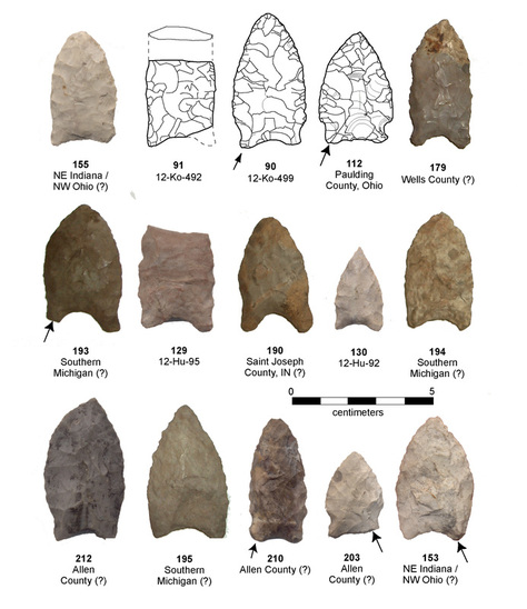
Based on a correspondence analysis and some histograms of basic size and shape variables, I argued that the Gainey-Barnes-Holcombe sequence recognized in other parts of the Great Lakes made sense in northeastern Indiana. I thought that Hi-Lo appeared to be "outside" of this sequence, and suggested that a Dalton-like point form would be a much better technological ancestor than Holcombe for Hi-Lo. This pointed outside the region to explain the origins of Hi-Lo. Based on the similarities with Dalton, I guessed that a Quad/Dalton-like Hi-Lo ancestor would be found in central/southern Indiana or other parts of the Ohio Valley. I didn't have data to go on at that point, so it was just a logical hunch.
The model I proposed explained the profusion of Middle and Late Paleoindian point types in northern Indiana by a time-transgressive movement of populations connected to environmental change during the Pleistocene-Holocene transition. I saw Gainey-Barnes-Holcombe as a continuous technological sequence indigenous to the Great Lakes. As the environments in the region changed, the ranges of the peoples making those points would shifted to the northeast along with parkland and tundra environments. The ranges of groups adapted to boreal or deciduous forest environments would have shifted northward as those environmental zones expanded into the Great Lakes. This would explain the appearance of Hi-Lo with no direct technological antecedent in the area. At some point in that sequence, groups using Agate Basin points apparently expanded their range eastward from the Plains (across much of eastern North America). The figure below shows a static illustration of this model. 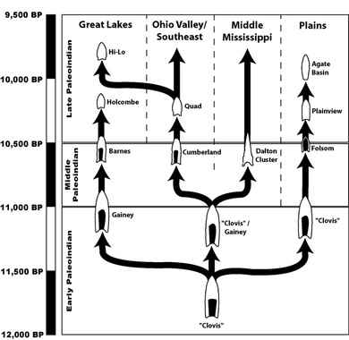
I also produced a short animation to explain the model during presentations. I kept it simple so that I could use it for a variety of audiences. I intended to add a soundtrack to it before putting it on YouTube, but I was thwarted by rapid changes in technology: newer versions of the same editing software that I used to produce the original animation just a few years ago are not able to open the file. If you want to create the effect I was going for, listen to this song while you watch the video.
My hunch that there would be a Quad/Dalton-like technological ancestor to Hi-Lo, was, I now believe, incorrect. After I wrote this 2006 paper I looked at many more collections from central and southern Indiana, northern Kentucky, southern Illinois, and central Ohio for my dissertation work. In those collections I saw nothing that I thought fit the bill for some kind of unknown "missing link" between early Cumberland or early Dalton and Hi-Lo. In fact, there seem to be some rather large spatial gaps in the distribution of Late Paleoindian points across central Ohio and south-central Indiana. Do these gaps reflect the presence of real discontinuities in the distribution of population during the Late Pleistocene? And how do we explain the distribution of Agate Basin points east of the Mississippi River? Good questions. 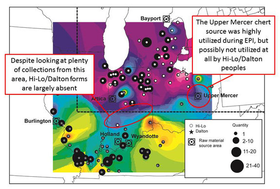
|